7.5 TRANSPORT REPORT A30 Chiverton to Carland Cross - TR010026 - Planning Act 2008
←
→
Page content transcription
If your browser does not render page correctly, please read the page content below
A30 Chiverton to Carland Cross
                     TR010026

     7.5 TRANSPORT REPORT

                                    Planning Act 2008

                              APFP Regulation 5(2)(q)
      Infrastructure Planning (Applications: Prescribed
              Forms and Procedure) Regulations 2009

                                             Volume 7

                                          August 2018
Infrastructure Planning

                           Planning Act 2008

                      The Infrastructure Planning
                  (Applications: Prescribed Forms and
                     Procedure) Regulations 2009

              A30 Chiverton to Carland Cross
              Development Consent Order 201[x]

                       7.5 TRANSPORT REPORT

Regulation Number:               Regulation 5(2)(q)
Planning Inspectorate Scheme     TR010026
Reference
Application Document Reference   7.5
Author:                          A30 Chiverton to Carland Cross Project Team,
                                 Highways England

Version     Date                 Status of Version
Rev: C01   21/08/18              Application Issue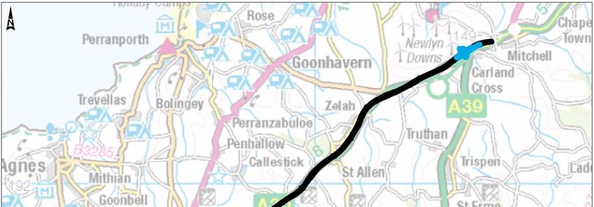
A30 Chiverton to Carland Cross | HE551502                            Highways England

Table of Contents
                                                                                    Pages
Executive Summary                                                                       2
1    Introduction                                                                       3
     1.1    Background                                                                  3
     1.2    Scheme Description                                                          3
     1.3    Scheme Objectives                                                           4
     1.4    Purpose of the Transport Report                                             5
2    Policy Context                                                                     7
     2.1    Overview                                                                    7
     2.2    National Policy Statement for National Networks (December 2014)             8
     2.3    National Planning Policy Framework                                          9
     2.4    Local Development Plan                                                      10
3    Existing Conditions                                                                12
     3.1    Overview of Existing Highway Network                                        12
     3.2    Observed Traffic Flows                                                      13
     3.3    Seasonality                                                                 15
     3.4    Observed Journey Times                                                      16
     3.5    Road Safety                                                                 20
     3.6    Sustainable Transport                                                       22
4    Base Year Model Development                                                        24
     4.1    Overview of Traffic Model                                                   24
     4.2    Model Time Periods                                                          24
     4.3    Model User Classes                                                          24
     4.4    Network Development                                                         24
     4.5    Matrix Development                                                          29
     4.6    Model Calibration                                                           35
     4.7    Model Validation                                                            37
5    Forecast Year Do Minimum Scenario Summary                                          40
     5.1    Approach                                                                    40
     5.2    Development Assumptions Included in Forecasts                               41
     5.3    Summary of DM                                                               49
6    Proposed Scheme                                                                    55
     6.1    Overview                                                                    55
     6.2    Construction of New Dual Carriageway                                        55
     6.3    Changes to Existing Local Roads                                             56
     6.4    Construction of New Walking, Cycling and Horse-Riding Routes                56
     6.5    Changes to Existing Walking, Cycling and Horse-Riding Routes                57
A30 Chiverton to Carland Cross | HE551502                         Highways England

     6.6    Construction Phasing                                                     58
7    Forecast Year Do Something Scenario Summary                                     59
     7.1    Approach                                                                 59
     7.2    Development Assumptions                                                  59
     7.3    Summary of DS                                                            61
     7.4    Walking, Cycling and Horse-Riding                                        67
8    Economic Appraisal                                                              70
     8.1    Introduction                                                             70
     8.2    Costs                                                                    70
     8.3    Travel Time and Vehicle Operating Costs                                  71
     8.5    Construction and Maintenance                                             73
     8.6    Environmental Impacts                                                    73
     8.7    Journey Time Variability                                                 74
     8.8    Wider Economic Impacts                                                   74
     8.9    Transport Economic Efficiency Table                                      75
     8.10      Analysis of Monetised Costs and Benefits Table                        76
     8.11      Adjusted BCR                                                          78
9    Summary                                                                         79
Abbreviations List                                                                   80

Table of Figures
Figure 1-1: Scheme Area                                                              4
Figure 3-1: Average Hourly 2015 Westbound Traffic Flows between Zelah and Carland
Cross                                                                                14
Figure 3-2: Average Hourly 2015 Eastbound Traffic Flows between Zelah and Carland
Cross                                                                                14
Figure 3-3: Monthly 2015 Westbound Traffic Flows between Zelah and Carland Cross
(TRADS 3708)                                                                         15
Figure 3-4: Monthly 2015 Eastbound Traffic Flows between Zelah and Carland Cross
(TRADS 3707)                                                                         16
Figure 3-5: Journey Time Routes                                                      19
Figure 3-6: Accident Map (January 2012 to December 2016)                             21
Figure 3-7: Extract from Cornwall Council's Full County Bus Map                      22
Figure 4-1: Simulation and Buffer Network Extents within Cornwall and Devon          27
Figure 4-2: Network Coverage in the Vicinity of the Scheme Area                      28
Figure 4-3: Model Simulation Area Zone Structure                                     30
Figure 4-4: Updated Cornwall Zone Structure                                          31
Figure 4-5: Devon Zone Structure                                                     32
Figure 4-6: Zone Structure of the Remainder of the UK                                33
Figure 8-1: Transport Economic Efficiency Table – Core Scenario (£000s)              76
Figure 8-2: Analysis of Monetised Costs and Benefits Table – Core Scenario (£000s)   77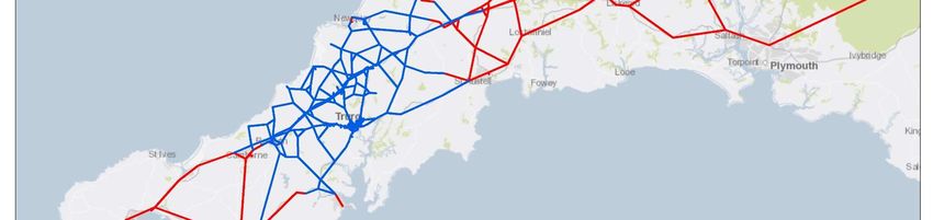
A30 Chiverton to Carland Cross | HE551502                           Highways England

Table of Tables
Table 3-1: Seasonality Indices for the A30 Between Zelah and Carland Cross            16
Table 3-2: Observed Journey Times (seconds) between Chiverton and Carland Cross 18
Table 3-3: Breakdown of Accidents by Severity and Year                                20
Table 4-1: Summary of User and Vehicle Classes                                        24
Table 4-2: Post ME2 Average Peak Hour Matrix User Class Totals                        34
Table 4-3: Number of Calibration Links and Screenlines that Pass TAG Criteria         36
Table 4-4: Proportion of Turns at Key Junctions that pass TAG Criteria                36
Table 4-5: Summary of Model Convergence                                               37
Table 4-6: Number of Validation Journey Times that pass TAG Criteria                  38
Table 4-7: Number of Validation Link Flows that pass TAG Criteria                     38
Table 5-1: Classification of Future Developments                                      42
Table 5-2: Total ‘Near Certain’ and ‘More Than Likely’ Developments (2038 Build Out
Levels)                                                                               43
Table 5-3: Trip Rates                                                                 44
Table 5-4: Development Trips                                                          45
Table 5-5: Intrazonal Trip Correlation Factors                                        46
Table 5-6: NRTF Growth Factors used for LGV and HGV Classes                           46
Table 5-7: Reference Case Forecast Matrix Totals                                      47
Table 5-8: Comparison of Matrix Totals                                                48
Table 5-9: Infrastructure Improvement Schemes for Inclusion in the Do Minimum Forecast
Modelling                                                                             49
Table 5-10: 2023 DM Convergence Results                                               50
Table 5-11: 2038 DM Convergence Results                                               50
Table 5-12: Journey Times Between Chiverton and Carland Cross                         51
Table 5-13: AM Peak A30 Link Flows in the Vicinity of the Scheme                      51
Table 5-14: IP Peak A30 Link Flows in the Vicinity of the Scheme                      52
Table 5-15: PM Peak A30 Link Flows in the Vicinity of the Scheme                      52
Table 5-16: AM Peak Key Route Link Flows in the Vicinity of the Scheme                53
Table 5-17: IP Peak Key Route Link Flows in the Vicinity of the Scheme                53
Table 5-18: PM Peak Key Route Link Flows in the Vicinity of the Scheme                54
Table 7-1: Reference Case Forecast Matrix Totals                                      59
Table 7-2: Comparison of Matrix Totals                                                60
Table 7-3: Infrastructure Improvement Schemes for Inclusion in the Forecast Modelling 61
Table 7-4: 2023 DS7A Convergence Results                                              62
Table 7-5: 2038 DS7A Convergence Results                                              62
Table 7-6: Journey Times Between Chiverton and Carland Cross                          63
Table 7-7: AM Peak A30 Link Flows in the Vicinity of the Scheme                       63
Table 7-8: IP Peak A30 Link Flows in the Vicinity of the Scheme                       64
Table 7-9: PM Peak A30 Link Flows in the Vicinity of the Scheme                       64
Table 7-10: AM Peak Key Route Link Flows in the Vicinity of the Scheme                65
Table 7-11: IP Peak Key Route Link Flows in the Vicinity of the Scheme                65
Table 7-12: PM Peak Key Route Link Flows in the Vicinity of the Scheme                66
Table 8-1: PCF Stage 3 Construction Costs (December 2017)                             70
Table 8-2: Benefits by Journey Purpose (£000s)                                        71
Table 8-3: COBA-LT Results                                                            72
Table 8-4: Safety Benefits                                                            72
Table 8-5: Construction and Maintenance Benefits (£000s)                              73
Table 8-6: Monetised Environmental Impacts                                            74
Table 8-7: Adjusted Benefit Cost Ratio                                                78

A30 Chiverton to Carland Cross | HE551502                    Highways England

HA551502-ARP-GEN-SW-RP-TR-000010 | C01, A3 | 21/08/18   PAGE 1 OF 81

A30 Chiverton to Carland Cross | HE551502                                       Highways England

Executive Summary
The section of the A30 in Cornwall from Chiverton to Carland Cross, experiences
congestion and delays throughout the year, with poor journey time reliability. The route
is in need of improvement to meet Highways England’s objectives of maintaining the
smooth flow of traffic, making the network safer and supporting economic growth.
The scope of the scheme is to upgrade 12.5km of single carriageway to dual carriageway
on the A30 between Chiverton and Carland Cross.
The specific Transport Objectives are:
 •   to contribute to regeneration and sustainable economic growth;
        −      to support employment & residential development opportunities;
 •   to improve the safety, operation & efficiency of the transport network;
 •   improve network reliability and reduce journey times;
        −      to deliver capacity enhancements to the SRN;
 •   supporting the use of sustainable modes of transport;
 •   delivering better environmental outcomes, and;
 •   to improve local and strategic connectivity.
This report summarises the development of the traffic model that has been used in the
appraisal of the scheme in terms of impact on the highway network and the economic
benefits of the scheme for Highways England Project Control Framework (PCF) Stage 3 in
support of the Development Consent Order.
In addition to summarising the development of the traffic model, this report also presents
the policy context for the scheme on a local, regional and national level. The policy
context addresses the requirement for the highway scheme as well as the needs of
Walkers, Cyclists and Horse Riders.

HA551502-ARP-GEN-SW-RP-TR-000010 | C01, A3 | 21/08/18                    PAGE 2 OF 81
A30 Chiverton to Carland Cross | HE551502                                      Highways England

1         Introduction
1.1       Background
          Following the completion of the dualling scheme to upgrade the A30 between
          Temple and Higher Carblake near Bodmin in 2017, the section of the A30 from
          Chiverton to Carland Cross is the only remaining single carriageway section of
          the A30 between the M5 at Exeter and Camborne in west Cornwall.
          The Chiverton to Carland Cross section of the A30 experiences congestion and
          delays throughout the year, with poor journey time reliability. These problems are
          exacerbated in summer months, when traffic flows increase due to tourist traffic.
          The route is in need of improvement to meet Highways England’s objectives of
          maintaining the smooth flow of traffic, making the network safer and supporting
          economic growth. The desire for improvements to this route is strongly supported
          by local and regional strategies from Cornwall Council, the Cornwall and Isles of
          Scilly Local Enterprise Partnership, businesses and local stakeholders.
          In 2014, it was announced as part of the Department for Transport’s (DfT) Road
          Investment Strategy (RIS) that a scheme to upgrade this final single carriageway
          section from Chiverton to Carland Cross to expressway standard would receive
          funding. Additionally, the scheme has received support from the European
          Union’s European Regional Development Fund, with a subsidy of £20 million
          available to assist in the development and construction stages.

1.2       Scheme Description
          The key elements of the scheme consist of:
          •   The construction of a new A30 dual carriageway road approximately 14
              kilometres between Chiverton and Carland Cross;
          •   The re-alignment of the existing A30;
          •   The construction of a new grade separated junction at Chiverton;
          •   The construction of a new grade separated dumbbell junction at Chybucca;
          •   The construction of a new grade separated junction at Carland Cross;
          •   Works to Allet Road for access across the new A30 at Tresawsen;
          •   The demolition and replacement of the existing bridge at Tolgroggan Farm;
          •   The construction of an underpass under the main carriageway of the new A30
              and the existing A30 at Trevalso;
          •   The construction of an underpass at Pennycomequick;
          •   The closure and stopping up of public highways and the existing A30; and
          •   The diversion of utilities including telecoms equipment, water pipelines, power
              cables and gas pipelines.
          These features were identified as meeting the current and future needs of road
          users, as well as achieving the high-level Government, Highways England and
          local objectives for the Strategic Road Network (SRN).
          Construction activities for the scheme would commence in March 2020, as
          identified in the Road Investment Strategy. The dual carriageway element of the
          scheme would be “open for traffic” in December 2022, however, the scheme
          construction would not finish until 2023.
          The scheme area can be seen in Figure 1-1.

HA551502-ARP-GEN-SW-RP-TR-000010 | C01, A3 | 21/08/18                     PAGE 3 OF 81
A30 Chiverton to Carland Cross | HE551502 Highways England
Figure 1-1: Scheme Area
1.3 Scheme Objectives
The scheme would:
• Contribute to economic growth by supporting employment and residential
development opportunities;
• Contribute to regeneration by enhancing the opportunities for previous,
existing and future regeneration projects to realise their full potential; and
• Minimise the environmental impact of operating, maintaining and improving
the network and seek to protect and enhance the quality of its surrounding
environment while conforming to the principles of sustainable transport.
The objectives for the scheme are to:
• Improve the safety, operation & efficiency of the transport network;
• Contribute to regeneration and sustainable economic growth;
• Support employment & residential development opportunities;
• Improve network reliability and reduce journey times;
• Deliver capacity enhancements to the SRN;
• Support the use of sustainable modes of transport;
• Deliver better environmental outcomes; and
• To improve local and strategic connectivity.
HA551502-ARP-GEN-SW-RP-TR-000010 | C01, A3 | 21/08/18 PAGE 4 OF 81A30 Chiverton to Carland Cross | HE551502 Highways England
1.4 Purpose of the Transport Report
As a Nationally Significant Infrastructure Project (NSIP), the scheme requires an
application for a Development Consent Order to be submitted to the Planning
Inspectorate, acting on behalf of the Secretary of State. This report forms part of
Volume 7 of the application for a Development Consent Order (DCO) authorising
Highways England to construct the scheme.
The purpose of this report is to provide a non-technical summary of the transport
planning works that have been completed to support the DCO submission for the
scheme. These include traffic modelling and economic appraisal works, in
addition to the Walking, Cycling and Horse-Riding (WCH) assessment and
review. The purpose of these works has been to:
• Quantify the impacts of the scheme on the highway network, in terms of
expected levels of congestion with and without the scheme in place;
• Provide traffic flow inputs to design of the new road and its junctions;
• Provide traffic flow inputs to the Environmental Impact Assessment (EIA) of
the proposed scheme;
• Provide inputs to the value for money assessment for the scheme, in terms of
the costs and benefits arising from the scheme for road users; and
• Assess the existing provision of WCH facilities in order to identify potential
opportunities for improvement and integration with the local and national
network(s) throughout the design process.
The traffic model is a strategic highway model, with a detailed study area that
covers from Indian Queens in the east, to Truro in the south, Redruth in the west
and Newquay to the north. The wider study area includes the major routes to the
west of Redruth, the A390 to the south of Truro towards Falmouth and the major
strategic routes within Cornwall and Devon such as the A39, A38 and A30.
Deliverables have been produced at each stage of Highways England’s Project
Control Framework (PCF) related to the traffic and economics workstream. The
PCF products that primarily underpin this document include the following:
• PCF Stage 3 Traffic Data Collection Report (TDCR) (HA551502-WSP-GEN-
0000-RE-TR-0012-P02);
• PCF Stage 3 Local Model Validation Report (LMVR) (HA551502-WSP-GEN-
0000-RE-TR-0013-P04);
• PCF Stage 3 Appraisal Specification Report (HA551502-WSP-GEN-0000-RE-
TR-0009-P03);
• PCF Stage 3 Traffic Forecasting Report (HA551502-WSP-GEN-0000-RE-TR-
0018-P03);
• PCF Stage 3 Combined Modelling and Appraisal Report (ComMA)
(HA551502-ARP-GEN-SW_WCH-RP-TR-000001);
• PCF Stage 3 Distributional Impacts Report (HA551502-ARP-GEN-SW-RP-TR-
000001-P04) and
• Operational Assessment Technical Note (HA5515020-ARP-HGN-SW-FN-TR-
000009-P01).
Additionally, whilst not PCF products, the Walking, Cycling and Horse-Riding
Assessment and Review Reports have also been utilised to inform the relevant
sections of this report:
HA551502-ARP-GEN-SW-RP-TR-000010 | C01, A3 | 21/08/18 PAGE 5 OF 81A30 Chiverton to Carland Cross | HE551502 Highways England
• Walking, Cycling and Horse-Riding Assessment Report (HA551502-ARP-
ENM-SW-RP-LE-000001); and
• Walking Cycling and Horse-Riding Review Report (HA551502-ARP-ENM-SW-
RP-LE-000019).
HA551502-ARP-GEN-SW-RP-TR-000010 | C01, A3 | 21/08/18 PAGE 6 OF 81A30 Chiverton to Carland Cross | HE551502 Highways England
2 Policy Context
2.1 Overview
To support the preparation of the traffic model and economic appraisal, it is
necessary to review National and Local Planning Policy and how this has
informed the overall approach. An assessment of the scheme’s compliance with
relevant policies is provided in the Planning Statement (Volume 7, Document
Ref 7.1).
The Planning Act 2008 (the Act) establishes the development consent regime for
Nationally Significant Infrastructure Projects. The Scheme is identified as a
highways NSIP under section 22 of the Act (as amended and described in full
above). The Planning Inspectorate has responsibility for administering the DCO
process and supporting the appointed examining authority, which is responsible
for examining applications and making a recommendation to the Secretary of
State as to whether to grant development consent.
The National Policy Statements (NPS) are of primary importance to the decision-
making process when DCO applications are being examined. Section 104 of the
Act states that:
(2) In deciding the application the Secretary of State must have regard to –
(a) any national policy statement which has effect in relation to development
of the description to which the application relates (a “relevant national policy
statement”)
(3) The Secretary of State must decide the application in accordance with any
relevant national policy statement, except to the extent that one or more of
subsections (4) to (8) applies.”
The National Policy Statement for National Networks (NN NPS) is relevant to the
proposed A30 Chiverton to Carland Cross. This NPS forms the basis against
which the scheme will be examined.
In addition, the National Planning Policy Framework (NPPF) published in July
2018 sets out the Government’s planning policies for England. The NPPF is likely
to be an “important and relevant”1 matter to be considered in decision making for
NSIPs. The NPPF is supplemented by the Planning Practice Guidance (PPG)2
web-based resource launched in February 2014. The PPG is updated by the
Department for Communities and Local Government as necessary.
It is important to note that applications under the Act are not subject to s38(6) of
the Planning and Compulsory Purchase Act 2004, which states that determination
of a planning application must be made in accordance with the local development
plan, unless other material considerations indicate otherwise. Local planning
policy may be an important and relevant matter during the consideration of
applications for development consent, but such applications do not have to be in
accordance with the development plan.
Development plan policies may be relevant considerations where they inform the
assessment of potential effects – for example, by identifying land allocations and
1
National Planning Policy Framework paragraph 3
2
Department for Communities and Local Government: Planning Practice Guidance: February 2014
HA551502-ARP-GEN-SW-RP-TR-000010 | C01, A3 | 21/08/18 PAGE 7 OF 81A30 Chiverton to Carland Cross | HE551502 Highways England
environmentally sensitive areas. If there is a conflict between the NPS and local
policies, however, the NPS takes precedence.
2.2 National Policy Statement for National Networks (December
2014)
The NN NPS sets the Government’s policy against which the Secretary of State
for Transport will make decisions on applications for development consent for
nationally significant infrastructure projects on road, rail and strategic rail freight
interchange developments3. Specifically, Paragraph 1.1 states that the purpose of
the NN NPS is to establish:
“the need for, and Government’s policies to deliver, development of nationally
significant infrastructure projects (NSIPs) on the national road and rail
networks in England. It provides planning guidance for promoters of nationally
significant infrastructure projects on the road and rail networks, and the basis
for the examination by the Examining Authority and decisions by the
Secretary of State.”
Drivers of Need for Development on the National Road Network
The NN NPS sets out the ‘vision and strategic objectives for the national
networks’. This recognises that there is a critical need to provide safe, expeditious
and resilient networks that better support social and economic activity, and to
provide a transport network that is capable of supporting economic growth and
rebalancing the economy.
“Government’s vision and strategic objectives for the national networks The
Government will deliver national networks that meet the country’s long-term
needs; supporting a prosperous and competitive economy and improving
overall quality of life, as part of a wider transport system. This means:
• Networks with the capacity and connectivity and resilience to support
national and local economic activity and facilitate growth and create jobs.
• Networks which support and improve journey quality, reliability and safety.
• Networks which support the delivery of environmental goals and the move
to a low carbon economy.
• Networks which join up our communities and link effectively to each
other.4”
Whilst the NN NPS is not scheme specific, it provides a decision-making
framework for applications on the strategic highway network. It does however
state that in some cases, it will not be sufficient to simply expand capacity on the
existing network, through factors such as junction improvements or new slips
roads, implementing ‘smart motorways’ or improving trunk roads. In these
circumstances “new road alignments and corresponding links may be needed
to support increased capacity and connectivity”5.
3
National Networks National Policy Statement (Paragraph 1.1)
4
National Networks National Policy Statement (Vision)
5
National Networks National Policy Statement (Paragraph 2.27)
HA551502-ARP-GEN-SW-RP-TR-000010 | C01, A3 | 21/08/18 PAGE 8 OF 81A30 Chiverton to Carland Cross | HE551502 Highways England
Assessment Principles
Unlike other types of infrastructure covered by the Act, the NN NPS deals
predominantly with linear infrastructure projects that are designed to link together
separate points. Development will usually be determined by economic activity and
population, as well as the location of existing transport networks6.
Paragraph 4.2 of the NN NPS sets out that subject to the detailed policies and
protections in this NPS, and the legal constraints set out in the Act, there is a
presumption in favour of granting development consent for national networks
NSIPs that fall within the need for infrastructure established in this NPS. In
considering proposed development, and weighing adverse impacts against
benefits, the Secretary of State should take into account:
• Its potential benefits, including the facilitation of economic development,
including job creation, housing and environmental improvement, and any long-
term or wider benefits;
• Its potential adverse impacts, including any longer-term and cumulative
adverse impacts, as well as any measures to avoid, reduce or compensate for
any adverse impacts7.
With regard to alternatives, Paragraphs 4.26 and 4.27 of the NN NPS set out that
applicants should comply with all legal requirements and any policy requirements
for the assessment of alternatives. Specifically, this will include: reference to the
EIA Directive, which requires projects with significant environmental effects to
include an outline of the main alternatives studied by the applicant; other legal
requirements for the consideration of alternatives, including under the Habitats
and Water Framework Directives; or a policy requirement of the assessment of
state that “all projects should be subject to an options appraisal”.
Section 5 of the NN NPS sets out the assessment criteria for the generic impacts
associated with a nationally significant road or rail scheme.
2.3 National Planning Policy Framework
Role of the NPPF and NPS
The overall strategic aims of the NPPF and the NPS are consistent, however, as
set out above, the two documents have two differing roles to play. Paragraph 5 of
the NPPF makes it clear that it does not contain specific policies for NSIPs for
which particular considerations apply. It goes on to state, however, that it may be
an ‘important and relevant’ matter to be considered in decision making for NSIPs.
The role of the NPS will be to assume the function of providing specific policies
and provide transport policy which will guide individual development brought
under it8.
Further details are provided in the Planning Statement (Volume 7, Document
Ref 7.1).
6
National Networks National Policy Statement (Paragraph 4.13)
7
National Networks National Policy Statement (Paragraph 4.3)
8
National Networks National Policy Statement (Paragraph 1.19)
HA551502-ARP-GEN-SW-RP-TR-000010 | C01, A3 | 21/08/18 PAGE 9 OF 81A30 Chiverton to Carland Cross | HE551502 Highways England
2.4 Local Development Plan
Although a DCO application is not subject to Section 38(6) of the Planning and
Compulsory Purchase Act 2004, development plans may be considered an
important and relevant matter.
The proposal falls entirely within the Cornwall Council Local Authority area.
Although there are a number of ‘saved policies’ within the Local Plan, the
development plan for the scheme area comprises:
• The Cornwall Local Plan Strategic Policies (2010-2030) which was formally
adopted on 22 November 2016, which represents the overarching planning
policy framework for the whole of Cornwall in the period up to 2030.
• The Cornwall Local Plan Strategic Policies (2010-2030) Community
Network Area Sections which act as a local focus for debate and
engagement and provide the basis for the place-based element of Cornwall’s
policy framework. The scheme is within both PP6 Truro and Roseland and
PP7 St Agnes and Perranporth Community Network Areas.
• The scheme falls partially within the north eastern section of the Truro and
Kenwyn Neighbourhood Development Plan, which sets out a number of
relevant development management policies in the Truro and Kenwyn
Neighbourhood Plan Area
There are also a number of guiding documents and supplementary planning
documents, set out below, which will also feature as material considerations.
Cornwall Local Plan Strategic Policies (2010-2030)
The A30 Chiverton to Carland Cross is identified on the Key Diagram within the
Cornwall Local Plan Strategy (2010-2030) as a Key Infrastructure Improvement.
Relevant policies for the project, which are set out in further detail within each
topic chapter of the Environmental Statement (Volume 6, Document Ref 6.2),
are as follows:
• Policy 1 Presumption in favour of sustainable development, sets out Cornwall
Council’s response to the NPPF which states that Council’s will take a positive
approach that reflects the presumption in favour of sustainable development.
• Policy 12 Design which sets out the Council’s ambitions to achieving high
quality, safe, sustainable and inclusive design in all development.
Development must ensure Cornwall’s enduring distinctiveness and maintain
and enhance its distinctive natural and historic character.
• Policy 23 Natural Environment states that development proposals will need to
sustain local distinctiveness and character and protect and where possible
enhance Cornwall’s natural environment and assets according to their
international, national and local significance. The policy sets out required
interventions and mitigation measures for each type of habitat, which will be
referenced within Chapter 8 Nature Conservation.
• Policy 24 Historic Environment states that development proposals will be
permitted where they would sustain the cultural distinctiveness and
significance of Cornwall’s historic rural, urban and environment by protecting,
conserving and where appropriate, enhancing the significant of designated
and non-designated assets. It further states that development within, or within
the setting, of the Cornwall and West Devon Mining Landscape World
Heritage Site (WHS) should accord with the WHS Management Plan.
HA551502-ARP-GEN-SW-RP-TR-000010 | C01, A3 | 21/08/18 PAGE 10 OF 81A30 Chiverton to Carland Cross | HE551502 Highways England
• Policy 27 Transport and Accessibility states that all developments should
provide safe and suitable access to the site for all people and not cause a
significant adverse impact on the local or strategic road network that cannot
be managed or mitigated.
• Policy 28 Infrastructure sets out that the requirements for developer
contributions and when these will be sought.
Local Plan Community Network Area Sections
The proposed scheme falls within two of the Community Network Area Sections.
These form the basis for the place-based element of Cornwall’s policy framework:
• Policies within the Truro and Roseland Community Network Area (PP6)
focus on ensuring the housing needs of the community are met (Objective 1)
and balancing the provision of employment and housing to reduce commuting
(Objective 2). Specifically, in relation to the proposed scheme, Objective 4 is
relevant and seeks to enable the use of more sustainable transport modes
and reduce congestion through the provision of additional transport
infrastructure. Objective 7 also seeks to ensure that the development is
adaptable, sustainable and of a high quality design and layout.
• In addition, the proposed scheme also falls within the St Agnes and
Perranporth Community Network Area (PP7). This Community Network
Area document focuses on “co-ordinating a strategic approach to the provision
of services and public transport to encourage self-containment and
sustainable transport” (Objective 4). In addition, Objective 8 seeks to “maintain
and enhance the area’s heritage and environmental assets for the benefit of
the local community and to enhance the area’s tourism offer”.
Truro and Kenwyn Neighbourhood Development Plan
The proposed scheme falls within the north eastern edge of the Truro and
Kenwyn Neighbourhood Development Plan. Alongside promoting sustainable
development (Policy E1), sustainable drainage (Policy E2) and green
infrastructure (Policy E4), the Neighbourhood Development Plan seeks to
promote employment growth at existing and new employment sites. In relation to
the proposed scheme, the NDP includes:
• Policy E7 Character of the Highways and Byways which seeks to retain and
enhance the character and materials of highways and associated structures;
• Policy T1 Truro Transport Strategy which sets a requirement for contributions
to the delivery of the Truro Transport Strategy.
• Policy T3 Sustainable Transport, which requires development to provide for
sustainable transport modes, reduce the need to travel and identifies key
routes for walking and cycling.
HA551502-ARP-GEN-SW-RP-TR-000010 | C01, A3 | 21/08/18 PAGE 11 OF 81A30 Chiverton to Carland Cross | HE551502 Highways England
3 Existing Conditions
3.1 Overview of Existing Highway Network
The A30 is 284 miles in length and runs from west London to Land’s End, forming
the primary connection to west Cornwall. As such, it retains trunk road status
under the management of Highways England from Honiton, east of Exeter, to
Longrock, east of Penzance.
Specific to the scheme, the section of the A30 from Chiverton to Carland Cross is
approximately 8 miles in length, consisting primarily of winding single carriageway
with a speed limit of 60mph. Short sections have been widened to two lanes to
facilitate the overtaking of slow-moving vehicles on the hilly terrain.
As the only main route to west Cornwall, the A30 is crucial to the resilience and
performance of transport infrastructure in the region, and the connectivity of west
Cornwall to the rest of the South West and wider UK. When incidents occur that
impede or block flow on the A30, there is no alternative direct route, forcing traffic
to queue on the main road or divert to minor roads which are not capable of
sustaining substantial traffic flows or movements.
The A30 also serves some north-south routes between two of Cornwall’s largest
settlements – Newquay and Truro – in addition to significant local movements
between numerous farms and small settlements along its route.
During neutral month peak hours9, the single carriageway A30 between Chiverton
and Carland Cross operates close to capacity, and is forecast to operate over
capacity by 2022 As such, this section experiences heavy congestion, which in
turn impacts on the local economy. Journey times show that the A30 currently
operates over capacity in the summer period due to the significantly increased
traffic flows during these periods.
Key Junctions between Chiverton to Carland Cross
There are three key junctions between Chiverton and Carland Cross, in addition
to the two roundabouts that bound this section of the A30.
At the western extent of the scheme, Chiverton Cross roundabout connects the
existing A30 trunk road to the A390 from Truro, the A3075 from Newquay and the
B3277 from St Agnes.
At the eastern extent of the scheme, Carland Cross roundabout connects the A39
from Truro to the existing A30 trunk road in addition to the local minor road
network. A gated access to the Carland Cross Windfarm forms the final arm of the
roundabout.
The three notable junctions along the scheme are:
• Chybucca, which connects the B3284 from Truro to the south-east and the
B3284 from Perranporth to the west on the north coast.
9 Department for Transport (2014) TAG Unit M1.2 – Data Sources and Surveys, Paragraph 3.3.6 [Online].
Available at: (https://www.gov.uk/government/uploads/system/uploads/attachment_data/file/427124/webtag-
tag-unit-m3-1-highway-assignment- modelling.pdf)
HA551502-ARP-GEN-SW-RP-TR-000010 | C01, A3 | 21/08/18 PAGE 12 OF 81A30 Chiverton to Carland Cross | HE551502 Highways England
• Zelah, where the existing A30 connects to the unclassified road between
Goonhavern and Shortlanesend by means of a grade separated connector.
• Boxheater, which connects:
− the A30 to the B3285 from Perranporth and Goonhavern to the west;
− the unclassified road which connects towards St Newlyn East, Cubert and
Newquay to the north; and
− the unclassified road southward to St. Allen, Trispen and Truro.
In addition to the above roads, 10 minor roads connect to the A30 at junctions
between Chiverton and Carland Cross. These serve communities each side of the
A30 and link into the local road network, providing access to villages and towns to
the north and south of the A30. These are predominantly single lane width
carriageways with high-sided hedges. There are also numerous individual
properties served by direct access to the A30.
Notable structures on the existing A30, which were constructed in the early 1990s
as part of the A30 Zelah Bypass scheme, are:
• The Tolgroggan overbridge carries an agricultural access road over the
existing A30 trunk road to the south of Zelah village at Tolgroggan Farm. The
structure spans a total of 42.5 metres above the rock cutting.
• The Twobarrows underbridge carries the A30 over the class 3 Zelah to
Shortlanesend road to the south of Zelah village. The bridge has a clear span
of 9.43 metres.
• Two existing culverts below the existing A30 carrying local watercourses to the
east of Zelah village.
3.2 Observed Traffic Flows
Traffic flows on the existing A30 and other local roads within the vicinity of the
scheme were identified through a number of different methods, including:
• Manual Classified Count (MCC) data collected by Cornwall Council in October
2012 at all the junctions on the A30 section from Chiverton to Carland Cross,
as well as at other key junctions in the area. The locations of these counts can
be found in Section 5 the PCF Stage 3 ComMA Report (HA551502-ARP-
GEN-SW_WCH-RP-TR-000001).
• Automatic Traffic Count (ATC) data available for key routes on the local
highways network from a series of ATC sites managed by Cornwall Council.
• Highways England’s TRADS traffic count database provided further traffic
count data on the A30.
The full details of the traffic data collection completed for the purposes of the
traffic modelling and economic appraisal can be found in the PCF Stage 3 Traffic
Data Collection Report (HA551505-WSP-GEN-0000-RE-TR-0012-P02).
Existing traffic conditions have been analysed on the A30 between Chiverton and
Carland Cross using the TRADS ATC counter between Zelah and Carland Cross
roundabout, which can be seen in Figure 3-1 and Figure 3-2.
Peaks in both graphs occur during the AM and PM peak periods - from this it can
be assumed that traffic is using the route in both directions as part of a commute.
HA551502-ARP-GEN-SW-RP-TR-000010 | C01, A3 | 21/08/18 PAGE 13 OF 81A30 Chiverton to Carland Cross | HE551502 Highways England
Figure 3-2 shows that the eastbound flow on the A30 experiences its largest level
of traffic during the PM peak. This trend could suggest that in the AM peak, these
vehicles could be using alternative routes such as the A3075 or A39.
Average Flow (Veh/hr)
TRADS_3708
Figure 3-1: Average Hourly 2015 Westbound Traffic Flows between Zelah and
Carland Cross
TRADS_3707
Figure 3-2: Average Hourly 2015 Eastbound Traffic Flows between Zelah and
Carland Cross
HA551502-ARP-GEN-SW-RP-TR-000010 | C01, A3 | 21/08/18 PAGE 14 OF 81A30 Chiverton to Carland Cross | HE551502 Highways England
Observed traffic flows on other local roads, in addition to the junction turning
counts along the A30 from Chiverton to Carland Cross can be found in the PCF
Stage 3 TDCR (HA551505-WSP-GEN-0000-RE-TR-0012-P02).
3.3 Seasonality
Figure 3-3 and Figure 3-4 show the average hourly traffic flows for each month of
the year between Zelah and Carland Cross on the A30.
Figure 3-3 shows the westbound monthly traffic flows for the A30. The graph
shows a peak in traffic levels during July and August with the trend indicating that
the route experiences its highest levels of traffic during the summer. This trend
can also be seen in Figure 3-4, where the traffic levels gradually increase
throughout the year from January to the peak summer months of July and August.
These two months are expected to be when traffic is busiest as Cornwall
experiences a high volume of tourist traffic over the summer period, especially
during the school summer break.
Figure 3-3: Monthly 2015 Westbound Traffic Flows between Zelah and Carland
Cross (TRADS 3708)
HA551502-ARP-GEN-SW-RP-TR-000010 | C01, A3 | 21/08/18 PAGE 15 OF 81A30 Chiverton to Carland Cross | HE551502 Highways England
Figure 3-4: Monthly 2015 Eastbound Traffic Flows between Zelah and Carland
Cross (TRADS 3707)
The most important descriptor of annual traffic flow patterns is the seasonality
index, which is defined as the ratio of the average August weekday flow to the
average weekday flow (Monday to Friday) in the neutral months of April, May,
June, September and October (excluding periods affected by bank holidays).
Using the annual report for the 2014 flows for the sites in the figures above, the
A30 in these locations is shown to be subject to the following seasonality indexes.
Table 3-1: Seasonality Indices for the A30 Between Zelah and Carland Cross
Site Seasonality Index
TRADS_3707 1.1841
TRADS_3708 1.1691
Non Built-up Trunk Road Typical Value (COBA Manual) 1.1000
The A30 between Zelah and Carland Cross is within the range of seasonality
index encountered (1.00 - 1.50) for a non-built-up trunk road as stated in the
COBA manual10. It is above the typical value of the seasonality index for a non-
built-up trunk road.
3.4 Observed Journey Times
Journey time data for vehicles travelling on the A30 was collected from Highways
England’s HATRIS journey time database. HATRIS is a national dataset of
average vehicle journey times between fixed points on the trunk road network.
The dataset contains average speeds of all vehicles passing between two points.
The list below details the location of the surveys on the A30:
10 Non-built-up trunk roads are defined as those roads owned and operated by the Secretary of State for
Transport (through Highways England), with speed limits above 40mph: Department for Transport (2017)
COBA 2017 User Manual, Part 4 – Traffic Input to COBA, Paragraph 6.1 [Online]. Available at:
(http://www.tamesoftware.co.uk/manuals/COBA_MANUAL/COBA2017%20Part%204%20(July%202017).pdf
HA551502-ARP-GEN-SW-RP-TR-000010 | C01, A3 | 21/08/18 PAGE 16 OF 81A30 Chiverton to Carland Cross | HE551502 Highways England
• A3074 Hayle and Penzance (westbound only);
• A3074 Nut Lane, Lelant and Tolvaddon Interchange;
• Tolvaddon Interchange and Scorrier Interchange;
• Scorrier Interchange and Chiverton Cross roundabout;
• Chiverton Cross roundabout and Carland Cross roundabout;
• Carland Cross roundabout and Mitchell Interchange;
• Mitchell Interchange and Chapel Town;
• Chapel Town and St Enoder;
• St Enoder and Indian Queens;
• Indian Queens and junction with A389/A391;
• Junction with A389/ A391 and Carminnow Cross;
• Carminnow Cross and Launceston Rd, Bodmin; and
• A30 Entry Slip and A395, Tregadillett (eastbound only).
These routes cover the A30 in detail between Lelant, near Hayle and Bodmin.
For none trunk road links journey time data has been supplied by Cornwall
Council from the Traffic Master database11, which covers the following routes:
• A390 between Chiverton Cross and County Hall, Truro;
• A39 between Carland Cross and Union Hill junction, Truro;
• A3075 between Chiverton Cross and Newquay;
• B3284 between Chybucca and Truro via Shortlanesend;
• A39 between Arch Hill, Truro and Carnon Gate, Devoran;
• B3285 between the A30 and the A3075;
• B3277 between Chiverton Cross and St. Agnes; and,
• A30 between Chiverton Cross and Carland Cross.
The Traffic Master data supplements the HATRIS data to provide a wider
coverage and the combined dataset is considered to have a sufficiently wide
coverage of the study area.
The locations of the journey time routes can be seen in Figure 3-5.
Section 7 of the PCF Stage 3 ComMA Report (HA551502-ARP-GEN-SW_WCH-
RP-TR-000001) summarises the analysis of the journey time data in terms of
quality, reliability and difference between the HATRIS data and Cornwall
Council’s data.
In the development of the A30 Chiverton to Carland Cross traffic model a
combination of HATRIS data from Highways England (for the A30 west and east
of the scheme) and the Traffic Master data from Cornwall Council for the A30
scheme and non-trunk roads was used for journey time validation. The Traffic
Master data for the scheme is summarised in Table 3-2.
11 Traffic Master data is GPS data sourced and centrally purchased by the Department for Transport. It is
used to provide detailed analysis of congestion using GPS records to calculate the speed of traffic on
different days and times.
HA551502-ARP-GEN-SW-RP-TR-000010 | C01, A3 | 21/08/18 PAGE 17 OF 81A30 Chiverton to Carland Cross | HE551502 Highways England
Table 3-2: Observed Traffic Master Journey Times (seconds) between Chiverton
and Carland Cross
Direction Data Source AM IP PM
Cornwall Council (Traffic 684 642 702
Eastbound
Master)
Cornwall Council (Traffic 804 673 748
Westbound
Master)
Journey times for the remaining routes can be found in Annex C of the PCF Stage
3 TDCR (HA551505-WSP-GEN-0000-RE-TR-0012-P02).
HA551502-ARP-GEN-SW-RP-TR-000010 | C01, A3 | 21/08/18 PAGE 18 OF 81A30 Chiverton to Carland Cross | HE551502 Highways England Figure 3-5: Journey Time Routes HA551502-ARP-GEN-SW-RP-TR-000010 | C01, A3 | 21/08/18 PAGE 19 OF 81
A30 Chiverton to Carland Cross | HE551502                                      Highways England

3.5       Road Safety
          A summary of traffic Personal Injury Accidents (PIA) was provided by Cornwall
          Council for the A30 between Chiverton and Carland Cross between 01/01/2012
          and 31/12/2016. During this period there was a total of 1 fatal, 17 serious and 93
          slight accidents.
          Figure 3-6 shows the location of the accidents within the study area. Accidents
          were more frequent in the vicinity of Chiverton Cross, Carland Cross, Zelah Hill,
          Chybucca and Callestick / Allet Cross junction.
          Regarding severity, the map does not show a clear distributional pattern of the
          killed or seriously injured (KSI) collisions. Out of 17 serious collisions, four
          occurred at Chiverton Cross, two at Carland Cross with the remaining four spread
          along the route. The only registered fatal collision occurred near Chybucca
          junction.
          Table 3-3 shows the breakdown of the accidents by year and severity.
Table 3-3: Breakdown of Accidents by Severity and Year

        Year                  Fatal            Serious        Slight              Total
 2012                           0                  2            17                  19
 2013                           1                  2            13                  16
 2014                           0                  4            25                  29
 2015                           0                  3            20                  23
 2016                           0                  6            18                  24
        Total                   1                 17            93                 111

HA551502-ARP-GEN-SW-RP-TR-000010 | C01, A3 | 21/08/18                     PAGE 20 OF 81
A30 Chiverton to Carland Cross | HE551502 Highways England Figure 3-6: Accident Map (January 2012 to December 2016) HA551502-ARP-GEN-SW-RP-TR-000010 | C01, A3 | 21/08/18 PAGE 21 OF 81
A30 Chiverton to Carland Cross | HE551502                                              Highways England

3.6       Sustainable Transport
          Bus
          Two bus routes utilise the A30 within the study area:
              a. Route 85: Operated by First Kernow from Newquay to Truro via Crantock,
                 St. Newlyn East and Shortlanesend. The 85 operates hourly Monday-
                 Friday, only utilising a section of the A30 between Boxheater and Allet
                 Common.
              b. Route 460: Operated by Summercourt Travel on behalf of Travel Cornwall
                 from Truro to Bude, via Wadebridge and Wainhouse Corner. The 460 is a
                 very low frequency bus service, with only Monday AM and Friday PM
                 services operating solely on schooldays.
          The routes for these services can be seen in Figure 3-7.

Figure 3-7: Extract from Cornwall Council's Full County Bus Map12

12 Cornwall Council. Full County Bus Map. 18 May 2017. Available from:
https://www.cornwall.gov.uk/media/28933622/countymap.pdf (Accessed 4 June 2018)

HA551502-ARP-GEN-SW-RP-TR-000010 | C01, A3 | 21/08/18                             PAGE 22 OF 81
A30 Chiverton to Carland Cross | HE551502 Highways England
Rail
There are no railway lines or stations within the immediate vicinity of the A30 from
Chiverton to Carland Cross. The nearest station is in Truro to the south of the
study area, which forms part of the Cornish Main Line to Penzance. To the north,
there is a branch off the Cornish Main Line – the Atlantic Coast Line – which
connects to Newquay from Par.
Services are operated on these lines primarily by Great Western Railway, with
some long distance services operated by Cross Country. Service frequencies are
increased, in addition to supplementary routes, during the summer months by
both providers.
Walking, Cycling and Horse-Riding
The A30 is a heavily trafficked road and does not generally cater for pedestrians,
cyclists and horse-riders. It does however sever communities and walking, cycling
and horse-riding activity is more common on the side roads than along the A30
itself.
Pedestrian/cyclist facilities are provided on some, but not all, of the arms at the
Chiverton and Carland Cross junctions. Bus stops are located on the A30 at
Marazanvose and Zelah and a narrow footway runs along one side of the A30
between Zelah and Mount Pleasant. This is the only infrastructure along the A30
itself that caters for WCH.
From Chiverton Cross to Carland Cross, there are currently twelve locations
where people can cross the line of the proposed A30, including the two terminal
junctions. These crossings are a mix of ‘A’, ‘B’ and unclassified roads and public
rights of way. All are rural in character and a number are signed as ‘quiet lanes’
for shared use by pedestrians, cyclists and horse-riders.
Marazanvose is the busiest section of the A30 in terms of both pedestrians and
cyclists and the B3284 at Chybucca is popular with cyclists.
Improving the A30 corridor will not only relieve traffic congestion but also provide
an opportunity to improve facilities for WCH. The aim is to mitigate any potential
adverse impacts and enhance any short-comings with the existing infrastructure.
A key element of the strategy is to grade separate all the existing side road
crossings including quiet lanes with either an overbridge or underpass.
HA551502-ARP-GEN-SW-RP-TR-000010 | C01, A3 | 21/08/18 PAGE 23 OF 81A30 Chiverton to Carland Cross | HE551502 Highways England
4 Base Year Model Development
4.1 Overview of Traffic Model
The PCF Stage 3 A30 Chiverton to Carland Cross traffic model is a variable
demand highway model developed in SATURN (version 11.3.12U).
The basis of the assessment, for all PCF stages, is the 2009 Truro SATURN
Model that was designed to assess the impact of developments and highway
improvement schemes in the vicinity of the City of Truro, Cornwall. This model
was enhanced and refined through each of the PCF stages to more accurately
represent the highway network relevant to the assessment of the scheme.
It should be noted that a public transport model has not been developed through
any of the PCF stages, as the impact of the scheme on public transport routes
and usage is not considered to be significant.
4.2 Model Time Periods
The following time periods have been modelled:
• 07:00 – 10:00 average hour – AM peak period;
• 10:00 – 16:00 average hour – Interpeak period;
• 16:00 – 19:00 average hour – PM peak period.
The base year model is representative of an October 2015 neutral weekday
(Monday – Thursday).
4.3 Model User Classes
The model has three vehicle classifications: Cars, Light Goods Vehicles (LGV)
and Heavy Goods Vehicles (HGV). The car vehicle class has been further split
into three to represent three separate trip purposes, resulting in a total of five user
classes. Each vehicle class is represented in the trip matrices in terms of
Passenger Car Units (PCUs), where 1 PCU is equivalent to 5.75m. The user
classes, vehicle classes and PCU factors are summarised in Table 4-1.
Table 4-1: Summary of User and Vehicle Classes
User Class Trip Purpose Vehicle Class Vehicle Type PCU Factor
1 Employers Business
2 Commute 1 Car 1.0
3 Other
4 All 2 LGV 2.0
5 All 3 HGV 2.0
4.4 Network Development
The network development process is described in Section 10.1 of the PCF Stage
3 ComMA Report (HA551502-ARP-GEN-SW_WCH-RP-TR-000001).
The model network is split into two types: simulation network and buffer network.
Figure 4-1 shows the extents of the simulation and buffer network within Cornwall
and Devon.
HA551502-ARP-GEN-SW-RP-TR-000010 | C01, A3 | 21/08/18 PAGE 24 OF 81A30 Chiverton to Carland Cross | HE551502 Highways England
The simulation network represents the highway network modelled in the greatest
level of detail, which covers from Indian Queens in the east, to Truro in the south,
Redruth in the west and Newquay to the north. The simulation network also
includes the major routes to the west of Redruth, the A39 to the south of Truro
towards Falmouth and the major strategic routes within Cornwall and Devon such
as the A390, A38 and A30. The simulation network has therefore been developed
to accurately represent the key routes to the main population centres near to the
scheme.
During the PCF Stage 3 model development, the network has been further
enhanced along the A30 corridor by the inclusion of all junctions with smaller
unclassified roads between the Chiverton Cross and Carland Cross roundabouts.
These updates to the network can be seen in Figure 4-2. Where necessary, new
zones have been created for these accesses to reflect the localised demand
generated by adjacent farms and hamlets. Cornwall Council has been consulted
to assist in the identification of the additional network links and nodes required.
The simulation network is now formed of the following sections and areas:
• A30 between Indian Queens and Redruth;
• A3075 between Chiverton Cross Roundabout and Newquay;
• The city of Truro;
• The key routes around the western side of Redruth;
• Minor routes to smaller population centres have been added including routes
to Perranporth and St Agnes located north of the A30.
The buffer network extends beyond that shown in Figure 4-1 to cover the rest of
the UK, which is modelled using the major SRN routes used to access major
population centres such as the M5 and M4. This allows realistic modelling of long
range trips. Fixed speeds were coded on these links because there is only partial
trip representation in this area.
Each link in the simulation network was surveyed to determine the link speed,
layout and standard of that particular section of road, with detailed junction coding
applied. Information was input to the model in relation to capacities, lane
allocations and priorities at individual junctions. Fixed traffic signal timings were
obtained from Cornwall Council. The saturation flows of the key junctions were
based on those specified in Highways England’s Regional Transport Model
(RTM) Network Coding Manual (Version 08), as was used in the development of
the South-West Regional Transport Model (SWRTM).
Speed-flow curves were added to a number of routes through the network in
order to limit link capacity and provide a better representation of traffic speed at
times of high traffic flow. This was particularly important to accurately model the
difference in capacities between dual and single carriageway sections of the A30.
Speed-flow curves have been added to routes in rural areas. In these areas link
capacity, rather than junction capacity, is the key constraint on flow. The speed-
flow curves have been obtained from the RTM Network Coding Manual (Version
08).
Local highways improvement schemes that had been completed prior to the base
year of 2015 were also identified and included within the model. These schemes
were:
• Trafalgar Roundabout, Truro;
HA551502-ARP-GEN-SW-RP-TR-000010 | C01, A3 | 21/08/18 PAGE 25 OF 81A30 Chiverton to Carland Cross | HE551502 Highways England
• Union Hill Junction, Truro; and
• Chiverton Cross Roundabout widening.
HA551502-ARP-GEN-SW-RP-TR-000010 | C01, A3 | 21/08/18 PAGE 26 OF 81A30 Chiverton to Carland Cross | HE551502 Highways England Figure 4-1: Simulation and Buffer Network Extents within Cornwall and Devon HA551502-ARP-GEN-SW-RP-TR-000010 | C01, A3 | 21/08/18 PAGE 27 OF 81
A30 Chiverton to Carland Cross | HE551502                                         Highways England

Figure 4-2: Network Coverage in the Vicinity of the Scheme Area

HA551502-ARP-GEN-SW-RP-TR-000010 | C01, A3 | 21/08/18             PAGE 28 OF 81
A30 Chiverton to Carland Cross | HE551502 Highways England
4.5 Matrix Development
The matrix development process is described in Section 10.2 of the PCF Stage 3
ComMA Report (HA551502-ARP-GEN-SW_WCH-RP-TR-000001).
Matrices were developed to determine the demand between each of the 907
zones within the model for each user class and for each time period.
Zoning System
Zones are specified within a strategic traffic model to represent the geographical
areas where demand on the highway network will originate from or arrive to.
The original zone system utilised within the 2009 Truro model was plotted in GIS
(Geographical Information Systems) software to understand the zone coverage.
Upon review, further detail was required for the zoning system in the vicinity of the
study area with multiple larger population centres disaggregated into smaller
zones as detailed later in this section.
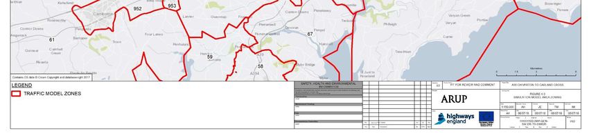
Figure 4-3 shows that the zone structure is very detailed within Truro itself but the
surrounding areas have been grouped into larger zones, with the exception of
Camborne, Redruth, Penryn and Falmouth which are large population centres
near to Truro. The other zones contained several settlements of varying sizes.
New zones were created, centred around population centres, which are likely to
use similar loading points on the network. The boundaries of these new zones are
based upon combined boundaries of the 2011 Census Output Areas. The
updated Cornwall zone structure can be seen in Figure 4-4.
To disaggregate the trips from the larger original zones, the original trip volumes
were assigned in proportion to the population of the new smaller zones. A table
showing the populations can be found in the PCF Stage 3 Local Model Validation
Report (HA11505-WSP-GEN-0000-RE-TR-0013-P04).
The original coverage of the 2009 Truro model included a single zone which
encompassed most of Devon, Exeter and the rest of the UK.
The Devon zone has been disaggregated around larger settlements and their
surrounding hinterland. These zones will load onto the network at the location of
the main population centre they contain e.g. Tavistock, Plymouth or Exeter. The
updated Devon zone structure can be seen in Figure 4-5.
The rest of the UK zones have been assigned based upon a regional structure
with the South West showing a further disaggregation given its proximity to the
study area (relative to the remainder of the UK). The zone structure for the
remainder of the UK can be seen in Figure 4-6.
During PCF Stage 3, new zones have been defined in order to increase the level
of detail in key areas of the network. Zones 900-907 represent different small
accesses, farms and hamlets that interact with the A30 through the whole length
of the scheme.
HA551502-ARP-GEN-SW-RP-TR-000010 | C01, A3 | 21/08/18 PAGE 29 OF 81You can also read