2022 Flood Contingency Plan - Prepared for: Municipalities and other partners/agencies in the Rideau Valley Watershed Prepared by: Brian Stratton ...
←
→
Page content transcription
If your browser does not render page correctly, please read the page content below
2022 Flood
                              Contingency Plan

Prepared for: Municipalities and other partners/agencies in the Rideau Valley Watershed

Prepared by:   Brian Stratton, P. Eng., RVCA Flood Forecasting and Warning Coordinator

                                 Date: February 2022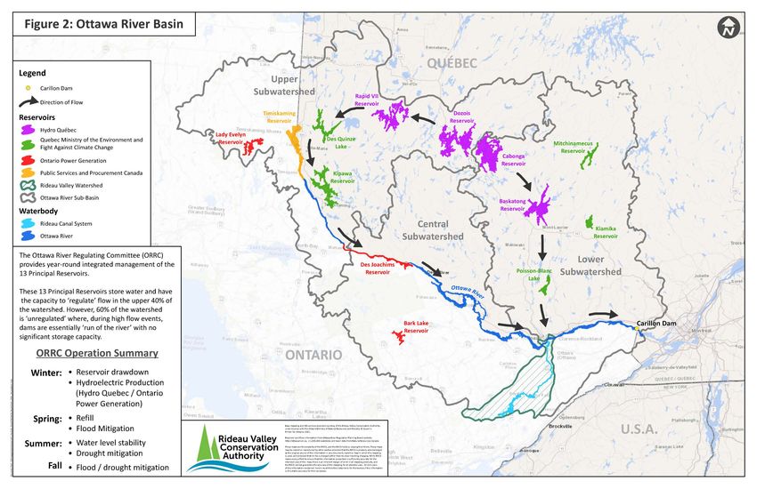
Table of Contents
1.0          Introduction ....................................................................................................................................1
2.0          Roles and Responsibilities ...................................................................................................... 2
               2.1          Conservation Authority .......................................................................................... 2
               2.2          Property Owner ...................................................................................................... 2
               2.3          Municipality ...................................................................................................................2
               2.4          Provincial Government ........................................................................................... 3
               2.5          Other Agencies ....................................................................................................... 3
3.0          Flooding in the RVCA Jurisdiction .......................................................................................... 5
               3.1          Lakes and Reservoirs............................................................................................... 5
               3.2          Rideau River Downstream of the Poonamalie Lock Station .................................. 5
               3.3          Ottawa River Watershed ........................................................................................ 6
               3.4          Causes of Flooding .................................................................................................. 6
               3.5          Flood Vulnerable Areas .......................................................................................... 6
4.0          RVCA Flood Forecasting and Warning Operations ............................................................. 8
               4.1          Data Collection Network ........................................................................................ 8
               4.2          Operations Centre / Contact List............................................................................ 8
               4.3          On-going Review of Ottawa River Conditions .................................................... 8
                              4.3.1            Lower Ottawa River Early Flood Warning Group ............................. 9
               4.4          Communications ............................................................................................................9
               4.5          Flood Messages .................................................................................................... 10
               4.6          Ottawa River Flood Messages .............................................................................. 12
               4.7          2021 Distribution List for Messages ..................................................................... 12

Figure 1: Rideau Valley Watershed .................................................................................................. 13
Figure 2: Ottawa River Basin ........................................................................................................... 14
Figure 3: Flood Vulnerable Areas, Rideau Valley Watershed .............................................................. 15
Table 1: RVCA Flood Vulnerable Areas.............................................................................................. 16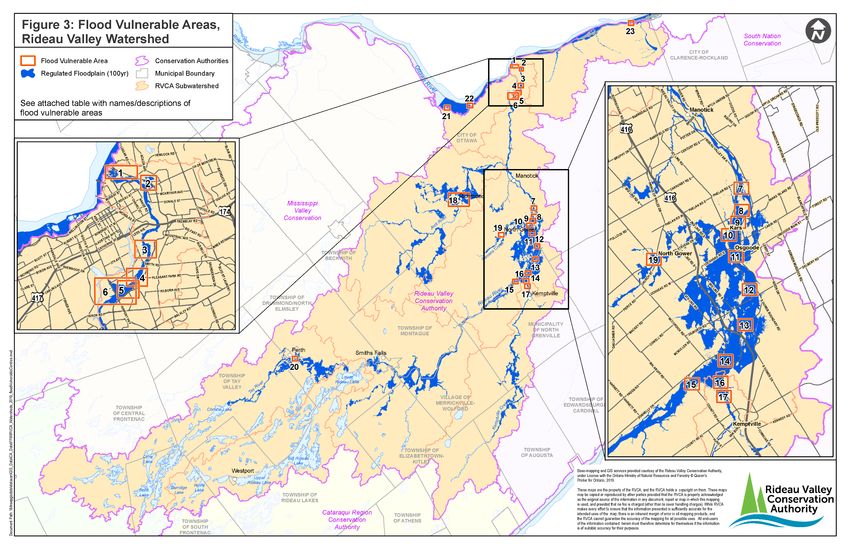
1.0 Introduction
 The Rideau Valley Conservation Authority (RVCA) 2022 Flood Contingency Plan was prepared in
 accordance with the provincial standards established in the Ontario Flood Forecasting and Warning:
 Implementation Guidelines for Conservation Authorities and Ministry of Natural Resources and
 Forestry’s document.

 The responsibility for dealing with flood contingency planning in Ontario is shared by municipalities,
 Conservation Authorities (CAs) and the Ministry of Natural Resources and Forestry (MNRF), on
 behalf of the province.

 The purpose of this manual is to provide an overview of how RVCA Flood Forecasting and Warning
 System operates. Key information presented in this manual includes:

     •   roles and responsibilities throughout a flood event
     •   key background information about water management in the RVCA
     •   RVCA flood forecasting and warning operations
     •   the RVCA flood message system

 This manual is not a municipal emergency preparedness plan and should not be used for that purpose.

The goal of the RVCA Flood Forecasting and Warning System is to provide an estimate of the
potential for river and stream flooding in the Rideau Valley watershed (see Figure 1) and, based on
that estimate, give sufficient advance warning to the designated municipal officials and members
of the public in order that appropriate steps can be taken to reduce the risk of loss of life, injury,
and property damage due to flooding.
 This plan will be revised, updated, and sent to the emergency contacts distribution list by RVCA,
 on an annual basis. The list includes emergency contacts from:
     -   Member Municipalities and Counties;
     -   MNRF Surface Water Monitoring Centre;
     -   MNRF Kemptville;
     -   MNRF Provincial Response Centre;
     -   Emergency Management Ontario;
     -   Ontario Power Generation;
     -   Ontario Provincial Police;
     -   Ottawa River Regulation Planning Board;
     -   Nation Capital Commission; and
     -   Neighbouring Conservation Authorities.

                                                    1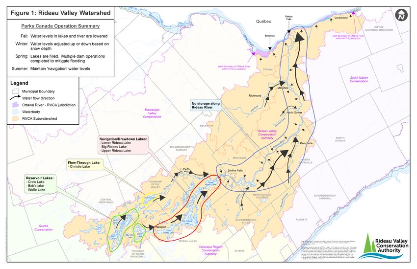
2.0       Roles and Responsibilities
The following is a summary of the roles of the RVCA, property owners, municipalities, provincial
government and others in the response to a flood emergency:

2.1       RVCA:

      The RVCA will develop and maintain a Flood Forecasting and Warning System. To implement its
      responsibilities, RVCA will:

      •   maintain a local network and carry out data collection
      •   assist MNRF in the delivery of flood forecasting and warning
      •   assess local conditions and forecast the response of rivers and streams
      •   receive early flood messages from MNRF’s Surface Water Monitoring Center (SWMC)
      •   access MNRF’s weather forecast and snow course data
      •   issue flood warning messages to watershed landowners and municipalities, MNRF and
          SWMC as conditions dictate
      •   provide local flood message information to MNRF District and the SWMC

      The Conservation Authority’s mandate includes Flood Forecasting and Warning only as
      summarized above. The RVCA’s role in flood combat is limited to ensuring that Authority
      properties are secure and that Authority water control structures are operated to minimize the
      impact of high flows.

2.2       Property Owner:

      Each property owner in a flood vulnerable area (low area along water body):
      •   is advised to be aware of the flood potential and have a flood contingency plan for minimizing
          the impact of flood waters (e.g. backup sump pump, generator, sandbags and sand and
          deployment plan)
      •   may contact municipality for assistance if extent of flooding exceeds their ability to respond

2.3       Municipality:

      To implement its responsibilities related to potential flood emergencies, each municipality will:
      •   prepare and maintain an Emergency Plan which shall have a section with details of personnel
          duties, the municipal equipment inventory and the deployment of both in the event of an
          emergency. The Municipal Emergency Plan can incorporate the RVCA’s Flood Forecasting and
          Warning Plan
      •   in the event of a flood beyond the individual property owners’ abilities to combat, the
          Reeve/Mayor may invoke the Municipal Emergency Plan and the municipality may provide a
          response to the flood threat
      •   contact Emergency Management Ontario (EMO; 1-866-314-0472 or 1-416-314-0472) to engage
          Provincial assistance if the degree of flooding exceeds the municipal capabilities. This will be
          done in accordance with the Municipal Emergency Plan

                                                        2
2.4 ProvincialGovernment:
Ministry of Community Safety and Correctional Services, OFFICE OF THE FIRE MARSHALL AND
EMERGENCY MANAGEMENT (Emergency Management Ontario (EMO)):
• receives municipal requests for assistance and coordinates the provincial response by assigning
responsibility for the emergency to the appropriate Ministry; provides support throughout the
event
Ministry of Natural Resources and Forestry (MNRF):
MNRF - Surface Water Monitoring Centre:
• maintains and makes available an information system to Conservation Authorities, MNRF District
offices where Conservation Authorities do not exist and any agencies responsible for water
control structures (e.g. Ontario Power Generation) to provide weather, river flow and snow cover
data
• provides interpretation of climatic conditions on a provincial scale and issues Provincial Flood
messages to Conservation Authorities and other agencies in affected areas
MNRF - Provincial Emergency Response Coordinator:
• prepares and administers a Provincial Flood Emergency Plan which includes authorization and
support for action at field level from other ministries (Environment and Climate Change, Health,
Community Safety and Correctional Services, Transportation)
• assesses the situation on receipt of a request for Provincial assistance via Emergency
Management Ontario and works with District staff to determine resource requirements to assist
municipal efforts
• if necessary, recommends to the Provincial Cabinet that an emergency ought to be declared
MNRF - District:
• once a local emergency is declared, the MNRF District Emergency Plan may be invoked, and
resources committed as deemed appropriate
• District staff can work directly to assist the municipality in consultation with the local
Conservation Authority
2.5 Other Agencies:
Parks Canada - Ontario Waterways:
• operates the Rideau Canal in the non-navigation period to provide flood storage by drawing down
the water level each fall and flood level reduction by manipulation of the dams to allow the passage
of river flows in as controlled a manner as possible throughout the spring freshet and other high
water periods
• operates and provides access to RVCA to stream gauges on the system
3City of Ottawa:
• removes the ice cover each spring from the Rideau River between Rideau Falls and the George
Dunbar Bridge (Bronson Avenue) to reduce the risk of ice-jam related flooding
• provides assistance to residents as needed as do other municipalities.
Ottawa River Regulation Planning Board (ORRPB)
• established to ensure integrated management of the principal reservoirs of the Ottawa River
Basin
• goal of this integrated management is to provide protection against flooding and maintain the
interests of the various users, particularly in hydro-electric energy production.
• Ottawa River Regulating Committee (ORRC) conducts the main operations for the ORRBP and is
made up of agencies that make the day-to-day decisions about the management of the reservoirs
with the Ottawa River Basin
• ORRC uses real-time data of water levels and flows collected throughout the basin as well as snow
monitoring data and weather forecast data to develop river conditions forecasts such as water
levels and flows along the main stem of the Ottawa River
• The Ottawa River Regulation Secretariat (ORRS) is the executive unit for the ORRBP and supports
the work of the ORRC.
To obtain water level and flow data and river condition forecasts, please visit the Ottawa River
Regulation Planning Board website: http://www.ottawariver.ca/river-levels-flows.php
43.0 Flooding in the RVCA Jurisdiction
The Rideau Valley watershed is 4,234 km2 in size and is shown on Figure 1. The Rideau River extends
from Burridge Lake, located just west of Westport, for 160 km to Rideau Falls in downtown Ottawa
where it discharges into the Ottawa River. The main tributaries on the Rideau River include the Tay River,
Jock River, and Kemptville Creek. There are also many smaller tributaries that drain into the
Rideau River. Dams on lakes and rivers operated or owned by the RVCA, Parks Canada, MNRF, and
power generation companies control flow. There are approximately 46 control structures in the Rideau
River watershed including 24 dams, 19 locks (on the Rideau Canal), and three power generating stations.
These structures can have a significant effect on surface water flows.
3.1 Lakes and Reservoirs
The upper portion of the Rideau Valley watershed contains many lakes that, when considered together,
represent a significant capacity for surface water storage. Bobs, Crow, and Wolfe Lakes are known as
‘Reservoir Lakes’ and are shown on Figure 1. Lower Rideau, Big Rideau and Upper Rideau Lakes are
known as ‘Navigational/Drawdown Lakes’ and are also shown on Figure 1. The Reservoir and
Navigational/Drawdown Lakes are used to store water in the upper watershed during the spring, and the
water is then released between June and October to help augment flows in the lower watershed.
Navigation lakes differ from reservoir lakes because of the need to maintain their water levels within
specific bounds during the navigation season. Christie Lake is located just downstream of Bobs Lake and
it’s referred to as a ‘flow-through lake’ because the water levels in Christie Lake are dependent on water
flowing from Bobs Lake.
Each year, water is released from Big Rideau Lake in support of the City of Ottawa ice management
program in the prefreshet period to the greatest extent possible.
Parks Canada springtime operations are aimed at filling each lake to its rule curve level by the end of the
spring freshet period, while preventing local flooding around each lake and excessively high outflows.
The current lake filling target is the start of navigation season on May 15 each year. The lakes are held as
near their ‘full levels’ as possible during the summer while satisfying downstream flow requirements.
These demands and evaporative losses result in gradual drawdown through the summer period. The
lakes are then brought down to their winter holding patterns after the navigation season.
3.2 Rideau River Downstream of the Poonamalie Lock Station
Downstream of the Poonamalie Lock Station, the channel reach sections of the Rideau River are
regulated to maintain levels in the required navigation range throughout the navigation season. In the
non-navigation season, the individual reaches are lowered to winter holding levels which are based on
experience and based on consultations with local fish and game clubs, trappers’ associations and MNRF
in order to reduce any impacts on the fisheries and fur bearing population.
The downstream control structures at Hogs Back and Black Rapids are normally stripped of stop logs
through the winter. This practice allows for the passage of any unexpected or early snowmelt flood
without the need to remove stop logs. The control structures for the longer reaches, for example at
Long Island, Merrickville and Kilmarnock are operated through the winter to preserve the natural
habitat along the river and in adjacent marshlands.
5Water levels along the length of the river rise prior to the freshet as flow is released for the City of
Ottawa ice management program. The freshet causes the level to rise a second time due to snowmelt
and spring runoff. The reaches are not filled to the navigation levels until early in May.
3.3 Ottawa River Watershed
The Ottawa River watershed (see Figure 2) is 146,300 km2 in size, which is twice the size of New
Brunswick. The Rideau Valley watershed is only 2% of the size of the Ottawa River watershed. The
limits of the Ottawa River which are within the RVCA jurisdiction are show on Figure 1 and go from
Watts Creek (west) through to the east boundary of Becketts creek watershed (east). The Ottawa
River watershed extends from Lac des Outaouais, Quebec, located 250 km north of Ottawa and
outlets into the St. Lawrence River in Montreal, Quebec. The Ottawa River watershed has 13 principal
reservoirs that are used for a variety of purposes, including hydroelectric generation, flood reduction,
and the release of water during winter months to help augment flows in the lower part of the
watershed. Although the Ottawa River watershed contains several reservoirs which act to store water
in the upper 40% of the watershed, 60% of the watershed is unregulated where dams are essentially
‘run of the river’ with no storage capacity during high flow events.
3.4 Causes of Flooding
Most flooding in the jurisdiction of the RVCA is a result of heavy continuous rainfall in combination
with snow melt. Flooding on the Rideau River typically occurs in the spring between March 26th –
April 12th with a median date of April 3rd as a result of a combination of snowmelt and precipitation
runoff with about 48 hours from when flows begin to increase to flood peak.
Unexpected or unusual heavy rains which can potentially happen at any time of the year and cause
flooding of small tributaries. For example, unprecedented rainfall in the Village of North Gower and
across the Rideau valley watershed on July 24, 2017 caused floodwaters in some homes and streets in
North Gower.
For the Ottawa River, high flows occur normally in the spring typically near the end of April as a
result of large rainfall events in combination with snow melt within the large Ottawa River
watershed. The peak flows from the numerous tributaries of the Ottawa River watershed occur at
different times and therefore typically produce two distinct peak flow events in the Ottawa River,
usually about three weeks apart. The first flood peak originates from unregulated flows from the
southern tributaries and is typically the lesser of the two peaks but with ice present, flood damage
can occur because of ice jams. The second peak is a result of a combination of high flows from the
northern tributaries and headwater areas and is partially regulated by reservoir operations. Two
very significant flood events occurred along the Ottawa River in 2017 and 2019.
3.5 Flood Vulnerable Areas
The areas at risk of being flooded up to the 1:100 year return frequency levels have been determined
by RVCA floodplain mapping studies. These areas are referred to as RVCA Flood Vulnerable Areas and
listed in Table 1 and shown on Figure 3. The RVCA flood prone vulnerable areas are mostly adjacent to
the Rideau River (16 areas) as well as Kemptville Creek, the Jock River, Steven Creek/Taylor Drain, the
6Tay River and Christie Lake, and the Ottawa River. On Table 1, some areas are referred to as ‘Area of
Reduced Flood Risk (RFR)’ which means a flood control structure (such as a berm, wall or pathway)
exists in this area to lower the risk of flooding. Also, on Table 1, it indicates the ‘return period when
residential dwellings start to become impacted’ if this information is available. The return periods were
calculated for each river or stream when the flood plain mapping studies were completed. The higher
return periods equate to higher flow and are explained below:
• A 1:100 year return period means that there is a 1% chance of this flow occurring in any year
• A 1:50 year return period means that there is a 2% chance of this flow occurring in any year
• A 1:20 year return period means that there is a 5% chance of this flow occurring in any year
• A 1:10 year return period means that there is a 10% chance of this flow occurring in any year
• A 1:5 year return period means that there is a 20% chance of this flow occurring in any year
• A 1:2 year return period means that there is a 50% chance of this flow occurring in any year
Although not shown on Figure 3 or included on Table 1, other flood vulnerable areas include:
• tributaries to the Ottawa River lying between the east boundary of the watershed of Watts Creek
on the west and the east boundary of the watershed of Becketts Creek on the east (Stillwater,
Graham, Pinecrest, Green, Bilberry, Taylor, Cardinal and Becketts Creeks)
• minor tributaries of the Rideau River (Sawmill, Nepean, Black Rapids, Mosquito and Mud Creeks).
These systems will have increased flows as a result of spring snowmelt and rainfall runoff but are also
susceptible to heavy localized rainstorms at any time of the year. Capital projects on Graham,
Stillwater, Bilberry and Sawmill Creeks have been undertaken to minimize the flood risk and/or bank
instability resulting from flood flows. New development on these and other watercourses is being
done with stormwater management, flood protection and geotechnical considerations incorporated
into the design because weather forecasting cannot be sufficiently precise to allow accurate and timely
flood warnings for these systems that react rapidly to very localized rainfall events (thunderstorms).
Therefore, the Authority does not provide flood forecasts or warnings specifically for these watersheds.
If heavy rainfall is forecast, residents in susceptible areas should take precautions.
Forecasts and warnings apply to the flood vulnerable areas discussed above and generally to any low-
lying area adjacent to waterbodies.
74.0 RVCA Flood Forecasting and Warning Operations
RVCA staff apply the Daily Planning Cycle (DPC) to determine what changes to water level and flow
conditions can be expected each day throughout the year. The DPC is a computer-based tool that brings
all the pertinent data into one place automatically. The data are assessed with the application of
spreadsheet-based models. The results are then incorporated into a Watershed Statement, if needed, that is
issued to partners and the public.
4.1 Data Collection Network
Snow Measurements - The Authority monitors six snow course locations in the lower watershed
(downstream of Lower Rideau Lake) on which flow forecasts are based. In addition, Parks Canada
measures snow cover in the upper watershed on which flow estimates for the Tay system and inflow
to the Rideau Lakes are based. From the snow measurements, the water equivalent is calculated and,
from that, an estimate is made of the depth of water lying on the watershed available to run off to the
waterways.
Weather Data – Precipitation, temperature and other weather data are acquired from the websites of
the Meteorological Services of Canada (a division of Environment and Climate Change Canada), the
Weather Office of the Aviation and Forest Fire Management Branch of MNRF, AccuWeather and The
Weather Network.
Water Levels/Streamflow - There are seventeen water level and/or streamflow monitoring stations
owned and/or operated by a variety of agencies (Water Survey of Canada (a division of Environment and
Climate Change Canada), Parks Canada, MNRF and RVCA) available to the Authority. These gauges are
polled daily through the year to monitor conditions in the Rideau system. The data is used in various
Authority programs but, primarily, it is the basis for RVCA Flood Forecasting and Warning.
4.2 Operations Centre / Contact List
All Flood Forecasting and Warning activities are coordinated from the Rideau Valley Conservation
Centre (RVCC) at 3889 Rideau Valley Drive. RVCA’s contact list for Flood Forecasting and Warning
can be found in Appendix 1, along with local contacts for MNRF and the Ministry of Community
Service and Correctional Services, Emergency Management Ontario.
4.3 On-going Review of Ottawa River Conditions
RVCA staff conduct on-going monitoring of Ottawa River flood conditions throughout the year,
especially during the months of April and May. Key tasks include:
• On-going review of water levels, flows, weather forecasts for Ottawa River Basin. See
https://ottawariver.ca/ for Current Conditions Summary and River Conditions Forecast.
• On-going / regular contact with Ottawa River Regulation Secretariat (Manon Lalonde and
Michael Sarich).
• Review of Ottawa River Regulation Planning Board (ORRBP) Press Releases and Bulletins.
• Review of Ottawa River Regulation Committee (ORRC) model results (not to be provided to
municipal staff or members of the public).
• Review of ORRC Peak level Forecasts (only available for significant flood events).
84.3.1 Lower Ottawa River Early Flood Warning Group
In 2019, Mississippi Valley Conservation Authority, RVCA, South Nation Conservation, Ottawa
River Regulation Planning Board, Ministry of Natural Resources and Forestry (MNRF) District
Office and MNRF’s Surface Water Monitoring Centre agreed to the formation of a Lower Ottawa
River Early Flood Warning Group to address flood conditions along the Ottawa River from
Arnprior eastward to the Carillon Dam (referred to as the Lower Ottawa River).
The main mandate of this group is to enhance and ensure consistent flood assessment and
warning along the Ottawa River from east of Arnprior to the Carillon Dam. The group meets
periodically outside of the flood season and more regularly during any high events on the Ottawa
River.
4.4 Communications
The RVCA Flood Forecasting and Warning Coordinator is responsible for the operation of the Flood
Forecasting and Warning System and responds to routine information requests from other agencies, the
public and the media. During a significant flood event, incoming telephone calls will be taken by
specifically assigned staff who will provide basic information. Requests for more detailed information or
media interviews will be coordinated by the Director of Communications and forwarded to the contact
person for that day. Flow information updated on a daily basis is available year-round on the Conservation
Authority webpage (https://www.rvca.ca/watershed-monitoring- reporting/reporting/streamflow-
water- levels#streamflow). All flood related statements are emailed to an extensive list of stakeholders,
landowners and medial contact, and also posted on the webpage and on Facebook and Twitter. Also, a
recorded message is accessible on the Authority telephone system (692- 3571 or 800-267- 3504, extension
1164.)
94.5 Flood Messages
Flood statements will be issued by e-mail to municipalities, area residents, print and electronic media,
MNRF offices, Parks Canada and to other agencies. The RVCA will issue flood related statements at any
time circumstances dictate. Generally, however, statements will be issued before noon so that there
will be sufficient time for recipients to initiate their response during the day.
All the messages are WatershedConditionsStatements andcome in the followingtypes:
NORMAL is when no flooding presently occurring
anywhere in the watershed.
1a. WATER SAFETY is issued to warn the public of
unsafe conditions around waterbodies at any time of
the year such as unstable ice sheets or a rain event that
could raise water levels quickly and make streambanks
slippery.
1b. FLOOD OUTLOOK is intended to advise municipalities
and the public that conditions over the next five days
could bring on flooding. This type of statement will be
issued at any time through the year when weather
forecasts of rain, melting and/or frazil ice accumulation
that could cause the water surface elevation to exceed
the bank full threshold above which overland flows begin
in the Rideau River system. This will be to make the public
and government officials aware of the situation in the
watershed and to give them time to review contingency
plans and make initial preparations.
There will be a FLOOD OUTLOOK statement issued
annually on or about March 1 regarding general flow
and snowpack conditions at that time. That statement
may include comments on other conditions such as ice-
jam potential and safety issues related to the flow
event.
2. FLOOD WATCH is published if it is determined that
surface water levels could surpass the threshold water
level above which there is perceived to be a risk of
damage to buildings and or contents and/or above
which the residents’ access to/from their homes is
compromised within the next 72 hour period, a FLOOD
WATCH statement will be issued to municipalities with
flood susceptible areas, MNRF and Parks Canada
offices, electronic media and newspapers by e-mail.
Municipal and individual resident preparations should
be completed.
103.FLOOD WARNING - If it is determined that
surface water levels will surpass the threshold
water level above which there is perceived to be a
risk of damage to buildings and or contents
and/or above which the residents’ access
to/from their homes is compromised, a FLOOD
WARNING statement will be issued at least 24
hours prior to the onset of flooding (rather than
24 hours prior to the forecast peak flow) to
municipalities with flood susceptible areas by e-
mail. MNRF and Parks Canada offices, electronic
media and daily newspapers will receive the
statement by e-mail addressed to the designated
contacts (if applicable). If messages are not
received, RVCA staff will phone relevant
contacts to ensure the information is received.
Municipalities will need to be ready to implement
their Emergency Plans. The MNRF District office
shouldbe prepared to deploy resources as
required and Rideau Canal operations should be
on an emergency basis. All media agencies are
expected to broadcast or publish the statement
immediately.
3a. UPDATE - FLOOD WATCH and FLOOD
WARNING UPDATE statements will be issued
every 24 hours or more frequently as
conditions dictate. The updates will continue to
be issued by e-mail to municipalities where
flooding is occurring as well as MNRF and
Parks Canada offices and media with a final
terminationstatementto advise that flood
waters are receding, and the flood emergency
is over.
114.6 Ottawa River Flood Messages
As indicated in Section 4.3 above, RVCA staff are part of the Lower Ottawa River Early Flood Warning
Group. When required, the group develops consistent flood messages for the Ottawa River.
4.7 2022 Distribution List for Messages
Appendix 2 provides a full list of names and emails for all municipalities and partners/agencies that are on
the RVCA flood message distribution list for the current year.
12Table 1
RVCA Flood Vulnerable Areas
Location River / Area of Reduced Flood Risk Return Period when Residential Dwellings
Description of Area
on Map Stream (RFR) start to become impacted
New Edinburgh o 20 year return period for most of area
o 10 year return period for houses on west
1 side of Crichton St, near St Patrick St
Bridge
Area of RFR due to presence of Kingsview Park / Vanier Parkway / o Between 50 and 100 year return period
2 NCC pathway known as North Landry Street
River Road
3 Brantwood Park / Onslow Crescent o Between 5 and 10 year return period
4a Rideau Gardens o Between 5 and 10 year return period
Area of RFR due to Windsor Windsor Ave o Between 5 and 10 year return period
4b
Park Dyke
5 Warrington Drive / Rideau River Lane o Between 5 and 10 year return period
Rideau Area of RFR due to Brewer Carleton University and Brewer Park o Between 20 year return period
6 River Park Dyke and corrugated steel
flood wall
7 Summerside Drive / Aston Road o 10 year return period
Carleton Golf / Lewis Way / Hurst o Between 5 and 10 year return period
8
Marina
9 CommodoreDrive o Between 5 and 10 year return period
10 Kars – Lorne Bridge Road o Between 5 and 10 year return period
11 Fennel Lane o Between 5 and 10 year return period
12 Rideau Valley Drive - Upstream of Kars o Between 5 and 10 year return period
13 Lannin Lane – Sheppard Way o Between 5 and 10 year return period
14 Fairmile – Hilly Lane o Less than 2 year return period
15 Rideau Glen – Becketts Landing o Approx. 2 year return period
between Smiths Falls and Poonamalie o Info not available
Locks (Smiths Falls Swale)
16 Cedar Beach Road – County Road 17 o Info not available
17 Kemptville Harris Road – Riverview Road o Info not available
Creek areas upstream of the Village of Oxford o Info not available
Mills
16Table 1
RVCA Flood Vulnerable Areas
Location River / Area of Reduced Flood Risk Return Period when Residential
Description of Area
on Map Stream (RFR) Dwellings start to become impacted
Richmond – parts of the Village, o Info not available
including areas on the tributaries
18
Jock (Bypass Drain, Flowing Creek and Van
River Gaal Drain
- areas on the tributaries Monaghan and o Info not available
Smith Drains and Leamy Creek
- in the vicinity of Twin Elm Bridge
Stevens North Gower – parts of the Village and o Info not available
Creek / areas downstream
19
Taylor
Drain
20 Perth – parts of the Town o Info not available
Tay Port Elmsley, Areas between Perth and o Info not available
River Glen Tay
21 Grandview o 10 year return period
Ottawa Area of RFR due to Britannia o Info not available
22
River presence of Britannia Berm
23 Boise Village – Morin Road o Between 5 and 10 year return period
Christie o Info not available
Lake
17You can also read