2021 Upper Restigouche - Canadian Heritage Monitoring Report 2010-2020
←
→
Page content transcription
If your browser does not render page correctly, please read the page content below
2021
Upper Restigouche – Canadian Heritage
        Monitoring Report 2010-2020

                          Prepared for the
                          Canadian Heritage Rivers Board

                          By Restigouche River Watershed
                          Management Council Inc.
                          March 31st, 2021
Executive summary
The Upper Restigouche River in New-Brunswick was designated a Canadian Heritage River
(CHR) in 1998. This report reviews efforts made from the time of designation to 2020
according to the Canadian Heritage River system’s integrity guideline and aims to describe
the degree of advancement of the river management plan and achievements. In all, this
determines whether heritage and recreational values are still intact and if the Upper
Restigouche continues to merit the CHR designation.
Since its designation, stakeholder organizations have remained active in promoting
dialogue; harmonizing different activities to pursue habitat and fisheries survey programs,
education and habitat improvement.
The Restigouche River Watershed Management Council (RRWMC), created in 2002, took
over the role of the original Restigouche River Management Committee, which is a
stakeholder organization carrying out the objectives of improving the river.
In general, the heritage values of the Upper Restigouche River remain intact and the
continuous work done by different stakeholders to preserve its integrity warrants the
renewal of the designation of this section in the Canadian Heritage River System.
2
Upper Restigouche – Canadian Heritage Monitoring Report 2011-2021Table of contents
1. Introduction ................................................................................................................... 4
2. Nomination Process Background .................................................................................. 4
3. Methodology ................................................................................................................. 5
4. Chronology of events .................................................................................................... 6
5. Condition of the Values since Designation .................................................................. 11
5.1 Natural Heritage Values .......................................................................................... 11
5.1.1 Background and integrity guidelines .................................................................... 11
5.1.2 Changes and Threats to Natural Values since Designation ................................. 12
5.2 Cultural Heritage Values ......................................................................................... 16
5.2.1 Background and integrity guidelines .................................................................... 16
5.2.2 Changes and Threats to Cultural Values since Designation................................. 16
5.3 Recreation Values ................................................................................................... 19
5.3.1 Background and integrity guidelines .................................................................... 19
5.3.2 Changes and Threats to Recreational Values since Designation ......................... 19
6. Integrity Guidelines since designation ......................................................................... 23
7. Designation Document Recommendations and Current Status ................................... 29
8. Summary of Benefits and Costs since Designation ..................................................... 33
9. Overall Assessment and Conclusions ......................................................................... 34
10. References.............................................................................................................. 36
3
Upper Restigouche – Canadian Heritage Monitoring Report 2011-20211. Introduction
The Restigouche River is located in northern New-Brunswick and flows north-east towards
the Bay of Chaleurs and the Gulf of St. Lawrence. The New-Brunswick portion of the
Restigouche watershed covers approximately 735 900 hectares. The principal tributaries
are the Kedgwick, Patapedia and Upsalquitch rivers.
The designated section of the Restigouche River starts at its junction with Jardine Brook
and flows in a north-easterly direction, for a distance of 55 kilometers, to its junction with the
Patapedia River where the Restigouche becomes the interprovincial boundary with the
province of Quebec.
The Canadian Heritage River System (CHRS) is Canada’s program to promote freshwater
heritage conservation and recognize Canada’s outstanding rivers based on heritage and
recreation values. The program is a cooperative effort by federal and provincial/territorial
governments, which works to ensure long-term management and conservation of Canada’s
river heritage. CHRS requires annual reports, monitoring, and ten-year reviews to ensure
that CHRS Rivers maintain the values for which they were nominated.
The objectives of this report are to:
Present chronology of significant events, actions and research that have occurred
since the designation of the river;
Describe positive or negative changes or threats to the state or condition of the
values for which the river was originally designated (natural, cultural, recreational or
integrity values);
Present the status of actions and management measures called for in the
designation document tabled with the Board;
List and describe river conservation, stewardship, economic, and cultural benefits
resulting from designation;
Assess the river’s ability to meet the criteria outlined in the designation document for
continued designation as a Canadian Heritage River.
2. Nomination Process Background
The Upper Restigouche River was nominated to the CHRS in January 1995 after
showing it met the guidelines for each of the values outlined by the integrity guidelines. The
river was officially designated as a CHR in 1998 when the River Management Committee
submitted the management plan.
This management plan was prepared based on extensive consultation with
individuals interested in the Restigouche River, including local historians, non-governmental
4
Upper Restigouche – Canadian Heritage Monitoring Report 2011-2021organizations, naturalists, wood harvesting companies, fishing camp owners and managers,
recreationists, relevant government departments and First Nations.
The planning process resulted in the establishment of a «River Management
Committee» comprised of the various stakeholders within the Restigouche River System. A
key objective of this group was to assist in the development and implementation of the
management plan. Unfortunately, due to a lack of funding, the River Management
Committee ceased to exist in 1999.
In 2002, another organization, the Restigouche River Watershed Management
Council inc. (RRWMC) was created with the mission to protect the Restigouche’s salmon
population and habitat. The Listuguj and Eel River Bar First Nations, the Restigouche
Salmon Club, the «Corporation de gestion des rivières Matapédia et Patapédia» and the
Fraser Lodge (now Kedgwick Salmon Club) are the five founding members. The RRWMC is
now composed of a total of 19 directors, nine appointed and 10 elected, all representing
various groups from different sectors; eco-tourism, industries, municipalities, outfitters,
guides, non-profit organizations and public. The RRWMC has been managing the
Restigouche Recreation program since 2008 and continues to ensure there are
consultations between the different stakeholders of the Restigouche River. Over the years,
the RRWMC was offered to managed other province contracts for the maintenance of
crown reserve waters infrastructures for public anglers and for pool guardians enforcement.
3. Methodology
The Restigouche River Watershed Managements Council was given the task of preparing
this report in order to ensure the involvement of different user and to access up-to-date
information on the situation.
The main tools used to gain information on the state of the river and the progresses made
are:
Reviews of CHRS reports and field reports provided by the department of Natural
Resources
Restigouche River Watershed Management Council annual report review
Secondary source research
Interviews with key individuals
All the Restigouche River Watershed Management Council (RRWMC) newsletters, scientific
reports and recent annual reports were also reviewed to present the measures related to
the Upper Restigouche River.
A new set of tables were provided by the CHRS to insure the conformity of the 10 year
monitoring report with other designated Heritage Rivers.
5
Upper Restigouche – Canadian Heritage Monitoring Report 2011-20214. Chronology of events
The following table presents the chronology of events since the nomination of the river in
1995.
Table 1: Chronology of Events since the nomination and designation
Year Significant Events, Actions, Research or Studies since 1995
1995 Upper Restigouche River nomination is accepted
1995-1998 River Management plan preparation with the Restigouche River
Management committee
1998 Finalization of the River Management plan and acceptance of the Upper
Restigouche river as a designated Canadian heritage river
One week of festivities from Belledune to St-Quentin to promote the
designation
Launch of a folk music CD of original songs pertaining to the Restigouche
with 12 local artists
1999 Routine activities for the Restigouche River Recreation Program (campsite
maintenance, cleaning crew and education)
Bank stabilization along Kedgwick River
Management Committee involved in the preparation of the management
plan used to obtain CHRS designation ceased to exist (funding issues)
2000 Routine activities for the Restigouche River Recreation Program (campsite
maintenance, cleaning crew and education)
2001 Routine activities for the Restigouche River Recreation Program (campsite
maintenance, cleaning crew and education)
2002 Creation of the Restigouche River Watershed Management Council
2003 First observation of the Saprolegnia Fungus on salmon in the Restigouche
System
Four Mile and Jardine brook landing enhancement with cement pads by
the Management of Salmon of Restigouche and its Tributaries (MSRT)
6
Upper Restigouche – Canadian Heritage Monitoring Report 2011-20212004 Waterways issues forum to consult the public on canoeing issues
Restigouche Salmon Fishing plan
2005 Development and distribution of the canoeists Code of Ethics
Signing of the Memorandum of understanding between the RRWMC with
5 governments (N.-B., Québec, Canada, Listuguj First Nation and Eel
River Bar FN.) on salmon resource management
2006 Construction and installation of 15 picnic tables and 6 toilets on camping
sites
2007 Initiation of the Zero-Garbage program which consist of the distribution of
reusable garbage bags to canoeists associated with a prize draw to
encourage them to carry-in carry-out
«Others users» advisory committee created at the RRWMC
2008 First year the Restigouche River Recreation Program is managed by the
Restigouche River Watershed Management Council.
Development of the «Plan de gestion du programme récréatif de la rivière
Restigouche» (Restigouche River Recreation Program Management Plan)
by the Restigouche River Watershed Management Council
Confirmation of the presence of the invasive algae didymo
(Didymosphenia geminata) on the designated portion
Beginning of high-school conferences in 5 schools of the county to
educate youth on the importance of respecting other users and on how to
prepare a canoeing expedition
Beginning of aerial surveys to locate sediment runoff causing increased
turbidity after major rain events
2009 Major improvement of the campsites by adding 30 picnic tables and signs
referring to outboard regulations, mapping of the river and garbage
regulation
Addition of a service office at Rafting Ground hosted by a student to
increase education and facilitate contact with canoeists;
Students hired at the starting point (Kedgwick River) to distribute code of
ethic information and to register the canoeists.
7
Upper Restigouche – Canadian Heritage Monitoring Report 2011-20212009
(Continued)
Siltation trap built in the Five Fingers sub-watershed to reduce sediment
runoff from potatoes fields;
Implementation of the Zero-Garbage program by developing a poster, by
increasing quality of reusable garbage bags and by having a
communication officer to promote the program;
Improvement of 200 m of road leading to Down’s Gulch landing
2010 Improvement of the landing, access and parking lot at Down’s Gulch
landing
Improvement of the road leading to the 4 Mile landing on the Little Main
river
Implementation of the Zero-Garbage program by adding a number and a
plastic tag on reusable garbage bags to follow-up on the program’s
success rate
Study on the economic impact of Restigouche Fishing Camps by the
University of New Brunswick
2011 Upper Restigouche-Canadian Heritage Monitoring report 1998-2010
High definition pictures and thermal imagery acquisition project (1st of 3
years); 320 km surveyed in 2011
LIDAR imagery acquisition of the Five Fingers brook watershed to locate
and describe agricultural runoff problems
Study on impact of forestry on watershed with the Equivalent Cut area
methodology
2012 Feasibility study on the interprovincial designation of the Restigouche
River (including 4 public consultations).
High definition pictures and thermal imagery acquisition project (2nd of 3
years); 180 km surveyed in 2012
2013 Restigouche Salmon Fundraiser supper (April 6th 2013) including Salmo
Salar award recipients
Four public consultations on the business plan for the Restigouche
Wilderness Waterway proposal
8
Upper Restigouche – Canadian Heritage Monitoring Report 2011-20212013 Booth at the Promotion Plus event in Campbellton and 4 conferences in
(Continued) high schools of the area
Forestry field visit with local politicians and forestry company
representatives
Last year of high definition pictures and thermal imagery acquisition
project (3rd of 3 years); 180 km surveyed in 2013
Beaver dam location in relation with fish distribution surveys in the Little
Main Restigouche River
Tagging of kelts with sonar transmitters for migration study with Atlantic
Salmon federation
2014 With the contribution of a Transport Canada program, two patrollers hired
to promote boating safety
Major works were done in the Five Finger book watershed to reduce soil
erosion from potato farms
Beaver dam location in relation with fish distribution surveys in the Little
Main Restigouche River
Tagging of kelts with sonar transmitters for migration stydy with Atlantic
Salmon federation
Business plan of the Restigouche wilderness waterway was completed
and approved by the RRWMC
2015 The Department of Fisheries and Ocean implementation of a no retention
rules for salmon angling – Daily catch and release limit of 4 fish
Major works were done to restore and stabilize a 300m bank on the Little
Main Restigouche river.
Beaver dam location in relation with fish distribution surveys in the Little
Main Restigouche River
Tagging of kelts with sonar transmitters for migration study with Atlantic
Salmon federation
2016 Canada 150 ceremony held on July 9th in Kedgwick River and July 24th in
Robinsonville
The business plan of the «Restigouche Wilderness Waterway» concept,
which aims to create a 235 km linear park on most of the Restigouche
9
Upper Restigouche – Canadian Heritage Monitoring Report 2011-2021watershed canoable waters was presented to the New Brunswick Jobs
board.
2016
(continued) Boating restrictions proceeding will be evaluated towards provincial
organizations to address the increased size of motors and sea-doo
activities.
2017 A project design of the Restigouche Wilderness Waterway has been
prepared by the province of New Brunswick. Within this design, a mapping
of the view shed buffer along each side of the rivers was done.
Government delegation visit on the river for the Restigouche Wilderness
Waterway project
Works on the Five Fingers watershed to reduce siltation runoff
2018 Low water levels during July and August are lowering the traffic on the
river and closing of private fishing camps on certain periods. This is
impacting overall economic impacts of tourism in the region.
Short heavy rain events have caused siltation runoff from the Five Fingers
brook, tributaries of the Little Main Restigouche river. Water quality was
impacted by these events.
The province of New-Brunswick, through the Tourism, Heritage and
Culture Dept. held public open houses on the Restigouche Wilderness
Waterway. Round tables with stakeholders group were also organized to
consult on the concept and designs. The province is proposing a 20,000
ha of buffer and viewshed protection to be included in the Canada 2020
land conservation objectives.
2019 River Story map developed for the designated portion of the Restigouche
A forestry harvest impact on salmon habitat as been approved in 2019
and will starts in 2020, under a supervised student thesis with Université
de Moncton.
Development of a warm water protocol for salmon fishing
Environmental Impact assessment conducted in the Restigouche
Wilderness Waterway development
2020 “Restigouche: The Long Run of the Wild River”, Philip Lee book launch.
The report from the public open houses of 2019 and 2020, prepared by
the consultant, was completed and government officials are waiting
10
Upper Restigouche – Canadian Heritage Monitoring Report 2011-2021approval for release. Since government activities were slowed down by
Covid-19 in spring and summer, the Restigouche Wilderness Waterway
2020 project development has been delayed.
(continued)
In the federal strategy to increase protected areas to 17% in Canada, the
Government of New Brunswick have listed the 15,000 ha Crown land
targeted for the Restigouche Wilderness Waterway. Those are made of
riparian buffer zones and viewshed protection. This nomination is an
important gain for the region to ensure increased protection of the
Upsalquitch, Patapedia, Kedgwick, Little Main and Restigouche rivers and
therefore the designated section.
A forestry harvest impact on salmon habitat as been approved in 2019
and was initiated in 2020 and will continue in 2021-2022.
Department of Fisheries and Oceans change daily salmon catch and
release limit from 4 to 2
Wildlife assistant program initiated to increase presence and patrols
For all years from 2010 to 2020, annual work plan of different departments included:
Smolts salmon monitoring (smolts wheel survey) (except 2020 because of COVID) Dept.
Fisheries and Oceans Canada
Juvenile salmon survey and spawners snorkel count - Dept. Fisheries and Oceans
Canada
Water sampling and analysis (Department of Environment of New-Brunswick)
5. Condition of the Values since Designation
5.1 Natural Heritage Values
5.1.1 Background and integrity guidelines
Habitat for the Canadian lynx and eagles, both provincially endangered species, are
located adjacent to the designated section. In addition, a wide variety of rare or uncommon
vascular plants, mosses and lichens are found in this area. The major natural value of the
river is certainly the Atlantic salmon. The Southern Gulf region population is candidate to be
listed on the Species at Risk as specie of special concern. Restigouche River is considered
as one of the best salmon rivers in North America.
11
Upper Restigouche – Canadian Heritage Monitoring Report 2011-2021The designated section of the Restigouche provides an outstanding example of a river
environment resulting from the earth’s development during the Silurian and Ordovician
Periods of the Palaeozoic Era and from the ice flow of the Pleistocene Epoch of the
Cenozoic Era. It is a gently meandering river with areas of continuous natural erosion.
Notable features include islands, flood plains, terraces, dykes, pools, rocky outcrops, gravel
bars and depositional features. The topography ranges from low floodplains, to rolling hills,
to sheer rock faces. Together with the spruce-fir forest and its diverse lesser vegetation and
the opportunities for wildlife viewing, areas of exceptional natural beauty are presented
along the river corridor.
The nominated area is of sufficient size and contains all or most of the key interrelated and
interdependent elements to demonstrate the key aspects of the natural processes, features,
or other phenomena which give the river its outstanding natural value.
5.1.2 Changes and Threats to Natural Values since Designation
The following table presents changes and threats to the natural values that have been
observed since the designation, and identify how/if they were addressed. The values reflect
those that were identified in the nomination and designation for the heritage river.
Table 2: Natural Heritage Values since Designation
NATURAL VALUE DESCRIPTION OF REASON FOR ACTIONS TAKEN
CHANGE IN VALUE CHANGE IN RESPONSE
(e.g. Magnitude, Positive or (e.g. Threat, Stressor,
Negative Change, Immediate Management Action)
or Long-term)
1. HYDROLOGY
1.1 Drainage Basins: None NA NA
River channel within the
area is not negatively
impacted by any man-
made structures.
1.2 Seasonal Variation to extreme Climate changes Equivalent Cut area
Variation: Spring runs high and low calculation for all
often raise the river conditions are more watershed of 1000
levels several meters common. to 2000 hectares
over the mean high- Moderate negative was done in 2012.
water mark. July and long terme change In 2020, a research
August are generally
project to link
noted for their low water
levels resulting in hard forestry and size of
going for canoeists cuts per watershed
as been initiated
12
Upper Restigouche – Canadian Heritage Monitoring Report 2011-2021NATURAL VALUE DESCRIPTION OF REASON FOR ACTIONS TAKEN
CHANGE IN VALUE CHANGE IN RESPONSE
(e.g. Magnitude, Positive or (e.g. Threat, Stressor,
Negative Change, Immediate Management Action)
or Long-term)
1.3 Water Content: Moderate negative Extreme rain events Sampling and water
Water quality is rated as change is causing sediment content analysis
good to excellent and is runoff on some done annually
characterized by However, water quality is period (normally 4
negligible alteration still rated as good to times/year) by the
from natural water excellent and is Department of
quality. characterized by Environment on the
negligible alterations in
Kedgwick River
natural water quality and
a natural aquatic (tributary of the
invertebrate community. Upper Restigouche)
and at Rafting
Ground on main
Restigouche River
Restauration work
on going with farms
and industries on
the Five Finger
brook and forestry
roads
2. PHYSIOGRAPHY
2.1 Physiographic None
Regions:
Restigouche
Upsalquitch Ecodistrict
of the Uplands
Ecoregion
2.2 Geological None
Processes:
Representations of the
following stages of
surface geology
development are found
within the area: alluvial,
glaciofluvial, morainal
and pre-quaternary
sediments.
2.3 Hydrogeology: Moderate negative Natural erosion Bank stabilization
River features include change caused by earlier on a section of the
floodplains, terraces, ice run and peak designated river to
islands, dykes, rocky flows resulting of reduce bank erosion
outcrops, depositional climate changes and prevent pool
feature and deep pools.
filling. Assessment
of cutting area sizes
in sub watershed
13
Upper Restigouche – Canadian Heritage Monitoring Report 2011-2021NATURAL VALUE DESCRIPTION OF REASON FOR ACTIONS TAKEN
CHANGE IN VALUE CHANGE IN RESPONSE
(e.g. Magnitude, Positive or (e.g. Threat, Stressor,
Negative Change, Immediate Management Action)
or Long-term)
2.4 Topography: None
Characterized by a
rolling topography with
elevations ranging
approximately from 50
m to 400 m. Mean river
gradient of 1,3 m/km
3. RIVER
MORPHOLOGY
3.1 Valley Types: None
Streams entering the
river are characterized
by sharp V shaped
valleys
3.2 Channel Types: None
Not negatively impacted
by any man-made
structures
3.3 Channel Profile: None
Series of rapids, runs,
pools and riffles
3.4 Fluvial None
Landforms:
Experiencing reduced
elevation through a
series of rapids and
runs
4. BIOTIC
ENVIRONMENTS
4.1 Aquatic Long term negative Climate changes Aerial survey of cold
Ecosystems: Prime changes are changing the water sources and
freshwater ecosystem pattern of refuge was
suitable for salmonids precipitation and conducted. Cold
and macro invertebrates warming sources were
temperature. Water identified. Warm
temperature is water protocol was
increasing. Dept. developed for
Fisheries and Oceans fishing management
data confirms that
climate change is
affecting the region
with a significant long
term trend water
temperature increase
from 1.5°C to 2.6°C
per decade
14
Upper Restigouche – Canadian Heritage Monitoring Report 2011-2021NATURAL VALUE DESCRIPTION OF REASON FOR ACTIONS TAKEN
CHANGE IN VALUE CHANGE IN RESPONSE
(e.g. Magnitude, Positive or (e.g. Threat, Stressor,
Negative Change, Immediate Management Action)
or Long-term)
4.2 Terrestrial Positive long term Delimitation of view Province of New
Ecosystems: changes sheds and land Brunswick selected
Vegetation pattern of protection natural Restigouche River
the area is believed to area corridor for the
be the result of a increased
complex interaction of percentage of the
the landform structure
Federal land
and a history of fires
and logging. River protection objective
corridor is well
protected and
characterized by a mix
of plants and trees of
the Acadian forest.
5. VEGETATION
5.1 Significant Plant None 150 m buffer along
Communities: Mixed the designated
forest including eastern section is protected
white cedar, balsam fir, within the actual
and white spruce with Crown land forestry
scattered white pine. management plan
Hardwood species
including white and
yellow birch, trembling
aspen and balsam
poplar
5.2 Rare Plant None
Species: Crawe’s
sedge, variegated
scouring-rush, green
spleenwort and nodding
fescue.
6. FAUNA
6.1 Significant Negative change for Fish stocks are Annual surveys
Animal salmon long term variable from one done within the
Populations: year to the other. section
Combination of forest 2020 fish count was (Electrofishing
cover and associated above average. surveys, snorkel
ground vegetation Reasons for decline count of spawners).
supports an abundance are many; oceans Habitat restoration,
of wildlife. Section long
dynamic changes, obstruction removal,
been recognized as
being one of the best predation, climate enforcement, water
Atlantic Salmon rivers in changes, habitat quality improvement
North America. disconnectivity and and many other
quality, illegal project to improve
harvesting overall salmon
population
15
Upper Restigouche – Canadian Heritage Monitoring Report 2011-2021NATURAL VALUE DESCRIPTION OF REASON FOR ACTIONS TAKEN
CHANGE IN VALUE CHANGE IN RESPONSE
(e.g. Magnitude, Positive or (e.g. Threat, Stressor,
Negative Change, Immediate Management Action)
or Long-term)
6.2 Rare Animal Positive change; Lynx Long term Maintaining effort to
Species: Restigouche population seems to management increased protected
River provides habitat have increased measures natural areas
for Canada Lynx and considerably and
eagles which are expanded its range
provincially endangered
species
5.2 Cultural Heritage Values
5.2.1 Background and integrity guidelines
The Restigouche River System is synonymous with the regional history and is significant
from a national and provincial perspective. The river was initially used as a transportation
route by Micmacs who reaped the benefits of the abundant fish and wildlife resources while
using it as a transportation link to other watersheds and coastal routes in Canada and the
United States. The river was used by American Loyalists fleeing the war of independence in
search of farmland in the Bay of Chaleurs and in the Restigouche area.
The early salmon anglers, adventurers in search of Atlantic salmon, contributed to the local
history by establishing salmon angling camps which today reflect an historic architectural
style. These camps welcomed notable people. Personalities associated with the designated
section include: Dean Sage, W.F. Ganong, Stanford White, King Edward and G.F. Clarke.
The Battle of the Restigouche took place within the Bay of Chaleurs in front of the actual
town of Campbellton. The battle is noteworthy both from a Canadian and regional
perspective due to the impact it had on the people and their cultures and the subsequent
settlement in the region. It marked the arrival of English speaking immigrants to the region,
some of whom settled within the nominated section.
The Restigouche River has long been used by the forest industry to transport logs to mills
located in the estuary. This industry has played a major role in the history of the region and
local community development.
5.2.2 Changes and Threats to Cultural Values since Designation
The following table presents changes and threats to the cultural values that have been
observed since the designation, and identify how/if they were addressed. The values reflect
those that were identified in the nomination and designation for the heritage river.
16
Upper Restigouche – Canadian Heritage Monitoring Report 2011-2021Table 3: Cultural Heritage Values since Designation
CULTURAL VALUE DESCRIPTION OF REASON FOR ACTIONS TAKEN IN
CHANGE IN VALUE CHANGE (e.g. Threat, RESPONSE
(e.g. Magnitude, Positive Stressor, Management
or Negative Change, Action)
Immediate or Long-term)
1. RESOURCE
HARVESTING
1.1 Fishing: Salmon Negative change Decrease of stocks Annual fish stock
fishing camps since mid long term and management monitoring (surveys,
1800s in the section. Four restriction causing inventory of spawning
camps namely: Down’s disinterest in fishing salmon, catch data)
Gulch, Larry’s Gulch,
Kedgwick Lodge and
The Department of
Carter Hall Lodge. Crown
waters on the upper Fisheries and Oceans
section permit public implemented a full catch
access to salmon angling. and release for
Micmac fishing prior to recreational fishing in
sport fishing. 2015
1.2 Shoreline None
Resource Harvesting:
Lands cleared for
agriculture on the banks
became ideal spots for the
establishment of the fishing
camps. Log slides on steep
slopes that were used for
the log drive still visible.
2. WATER
TRANSPORT
2.1 Commercial None
Transportation:
River system was used
extensively to transport
logs to the mills which
were built adjacent to the
river estuary.
2.3 Exploration & None
Surveying:
Originally, Micmac and
Maliseet nations used the
river system as a
transportation corridor,
later utilized by Europeans
settlers, loggers and sport
fishermen.
17
Upper Restigouche – Canadian Heritage Monitoring Report 2011-2021CULTURAL VALUE DESCRIPTION OF REASON FOR ACTIONS TAKEN IN
CHANGE IN VALUE CHANGE (e.g. Threat, RESPONSE
(e.g. Magnitude, Positive Stressor, Management
or Negative Change, Action)
Immediate or Long-term)
3. RIPARIAN
SETTLEMENT
3.1 Sitting of None
Dwellings: River were
used by Europeans fleeing
the war of independence in
the United-States to reach
the Bay of Chaleurs
3.2 River-based None Interpretation poster on
Communities: the subject posted in the
Forestry and Salmon river offices
angling (using rivers for log
drive) were the two major
economic activities that
permitted development in
the area.
3.3 River-influenced None
Transportation:
Canoeing is part of the
heritage (fishing,
transportation route for
Micmac and Europeans,
logging). Major Micmac
transportation route which
provided connections to
other important watersheds
in Canada and in the
United States (St.John
River)
4. CULTURE &
RECREATION
4.1 Spiritual None
Associations: Salmon
and forest from the
Restigouche is the base of
Micmac culture and
spirituality
4.2 Cultural None
Expression: Multi-Ethnic
culture (Micmacs, Acad-
dians, Scottish, Irish,
French Canadians and
English)
4.3 Early Recreation: None
Major cultural influence of
the area is the long history
of salmon sport fishing
18
Upper Restigouche – Canadian Heritage Monitoring Report 2011-2021CULTURAL VALUE DESCRIPTION OF REASON FOR ACTIONS TAKEN IN
CHANGE IN VALUE CHANGE (e.g. Threat, RESPONSE
(e.g. Magnitude, Positive Stressor, Management
or Negative Change, Action)
Immediate or Long-term)
5. JURISDICTIONAL
USES
5.1 Environmental Positive long term Deleniation and The province has
Regulation: Crown changes nomination of the committed to doubling
Land administered under Restigouche its protected and
the province’s Crown corridor for natural conserved land and
Lands and Forest Act, by protected area freshwater from 4.6 per
the Department of Energy cent to 10 per cent
Natural Resources
Development
5.3 Recreation Values
5.3.1 Background and integrity guidelines
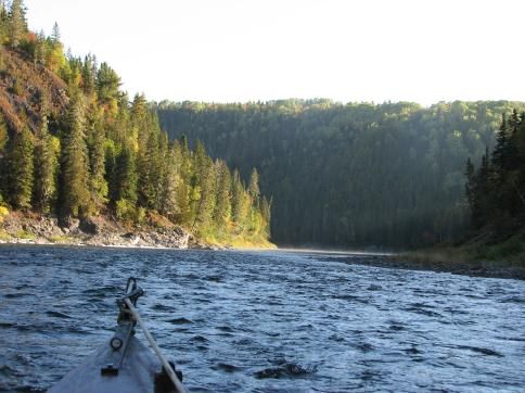
The Upper Restigouche River provides ample opportunity for recreation. The unique setting
of the river system provides a feeling of remoteness while still being close to civilization.
The river offers excellent opportunities for high quality sport fishing, recreational canoeing,
kayaking, sightseeing, nature interpretation, cultural and historical interpretation, camping
and trail development.
This section of the river has been used as a recreational waterway for the past 200 years
for sport fishing, and more recently in the past 40 years, for recreational canoeing. The
increased canoe traffic on the Restigouche River system has resulted in the Department of
Natural Resources’ decision to initiate and maintain a recreation program on the river. This
program, now managed by the Restigouche River Watershed Management Council, is
designed to address issues related to the increased recreational use of the river.
Designated campsites, four in the Upper Restigouche river section, have been maintained
to direct the users away from sensitive areas and fishing pools, and to provide toilets, fire
pits and tables to canoeists.
5.3.2 Changes and Threats to Recreational Values since Designation
The following table presents changes and threats to the recreational values that have been
observed since the designation, and identify how/if they were addressed. The values reflect
those that were identified in the nomination and designation for the heritage river.
19
Upper Restigouche – Canadian Heritage Monitoring Report 2011-2021Table 4: Recreational Values since Designation
RECREATIONAL DESCRIPTION OF CHANGE IN REASON FOR ACTIONS TAKEN
VALUE VALUE (e.g. Magnitude, Positive or CHANGE (e.g. Threat, IN RESPONSE
Negative Change, Immediate or Stressor, Management
Long-term) Action)
1. BOATING
1.2 Extended Canoe Positive changes Education program Annual recreation
Tripping (motor & and Code of Ethics, program managed
non-motor): 3 day Zero-garbage by the RRWMC to
canoe trips from the program, registration maintain and
Kedgwick River to of canoeists. improve facilities
Rafting Ground is still
the most popular canoe
activity
1.3 Day Paddling & None
Rowing: Day paddling
occurs in the section
1.5 Motorized Negative changes The proportion of jet Code of Ethics for
Pleasure boats (turbine with outboard users
cruising/Houseboats 15hp motor or more) distributed
on the river increased
in the time period Signs of Code of
covered by this report ethic and laws
and generate some placed at boat
conflict with other launches.
user
Government
Boating is more agencies enforcing
technical during boating regulation
extreme low water consequently
periods
2. ANGLING
2.1 Day Angling: Negative long term changes No retention (2015) Many projects to
Open water is available and reduction of daily improve salmon
in the section for salmon catch and release habitat and salmon
fly fishing from 4 to 2 (2020) is population stocks
affecting angling
interest
2.2 Weekend Negative long term changes No retention (2015) Many projects to
Angling and reduction of daily improve salmon
Same as 2.1 catch and release habitat and
from 4 to 2 (2020) is
increase salmon
affecting angling
interest population stocks
2.3 Extended Negative long term changes No retention (2015) Many projects to
Angling Vacation: 4 and reduction of daily improve salmon
salmon fishing camps catch and release habitat and
still in activity in the from 4 to 2 (2020) is
increase salmon
section affecting angling
interest population stocks
20
Upper Restigouche – Canadian Heritage Monitoring Report 2011-2021RECREATIONAL DESCRIPTION OF CHANGE IN REASON FOR ACTIONS TAKEN
VALUE VALUE (e.g. Magnitude, Positive or CHANGE (e.g. Threat, IN RESPONSE
Negative Change, Immediate or Stressor, Management
Long-term) Action)
2.4 Fly Fishing: Negative long term changes No retention (2015) Many projects to
Private access, and reduction of daily improve salmon
outfitters, public open catch and release habitat and
water and crown from 4 to 2 (2020) is increase salmon
reserved 3-day fishing affecting angling population stocks
trips are drawn in the interest
section (salmon)
2.5 Specific Fish None
Species: Salmon is the
most important fish
resource on the river
3. WATER-
ASSOCIATED
ACTIVITIES
3.1 Camping: 4 Positive change Improvement of Maintenance of the
campsites along the campsite in general 4 campsites located
river are accessible for on this section.
free, one privately Addition of facilities
owned campground in and equipment on
Kedgwick River campsites
4. NATURAL
HERITAGE
APPRECIATION
4.1 Wildlife : Offers None
outstanding
opportunities to view
wildlife such as moose,
bear, osprey, waterfowl,
birds and of course the
majestic Atlantic
Salmon.
4.2 Vegetation: 150 m Positive long term change Increase of the size Equivalent cut area
buffer zone is protected of buffer zone study for all 1000-
on both sides of the river (minimum 200m + 2000 ha watershed
on Crown lands (80 % of viewshed) within the started in 2012
the section). Private government
lands also provide a Protected natural
natural environment areas proposition
along the river.
21
Upper Restigouche – Canadian Heritage Monitoring Report 2011-2021RECREATIONAL DESCRIPTION OF CHANGE IN REASON FOR ACTIONS TAKEN
VALUE VALUE (e.g. Magnitude, Positive or CHANGE (e.g. Threat, IN RESPONSE
Negative Change, Immediate or Stressor, Management
Long-term) Action)
4.3 Vistas/Scenic None 150 m buffer will be
Quality: The river’s included again in
outstanding natural the next forestry
heritage features are management plan
neither environmentally 2012-2017
nor ethically impacted
by developments.
4.4 Geological None
Features/Water
Features: Floodplains,
steep rock outcrops and
the clear and cold water
of the river
5. HUMAN
HERITAGE
APPRECIATION
5.1 Historic Sites: None
Pool and camp names
and camp architectures
awaken imagination to
the life of the early river
travelers.
5.2 Cultural None
Landscapes: Impact
of the Kedgwick River
community and fishing
camp are minimal.
Represent the waterway
as it was in the past.
5.3 Sporting None
Events/Activities: Fly
fishing and canoeing
remain the main
sporting activities in the
designated section
22
Upper Restigouche – Canadian Heritage Monitoring Report 2011-20216. Integrity Guidelines since designation
The following table present more in details the specific integrity values that have
experienced changes since the designation.
Table 5. Specific integrity values that have experienced changes since the designation.
CHANGE IN THREAT OR ACTION(S)
NATURAL, CULTURAL INTEGRITY STRESSOR TAKEN TO THREAT STILL
OR RECREATIONAL VALUE (Current,
ADDRESS PRESENT?
INTEGRITY VALUE Immediate, Long-
term) THREAT
NATURAL 1.2 Variation to Climate Equivalent Cut Yes
Seasonal Variation: extreme high changes is in area calculation
Spring runs often and low cause with for all
raise the river levels conditions are
cumulative watershed of
several meters over more common.
the mean high-water effect of clear 1000 to 2000
mark. July and August cutting hectares was
are generally noted for done in 2012. In
their low water levels 2020, a
resulting in hard going research project
for canoeists to link forestry
and size of cuts
per watershed
as been
initiated.
Forestry plan
could mitigate
impact of
climate change
23
Upper Restigouche – Canadian Heritage Monitoring Report 2011-2021CHANGE IN THREAT OR ACTION(S)
NATURAL, CULTURAL INTEGRITY STRESSOR TAKEN TO THREAT STILL
OR RECREATIONAL VALUE (Current,
ADDRESS PRESENT?
INTEGRITY VALUE Immediate, Long-
term) THREAT
NATURAL 1.3 Water Extreme rain Sediments are Sampling and Yes
Content: Water events is entering water content
quality is rated as causing watercourses analysis done
good to excellent and that flows in the annually
sediment runoff
is characterized by Restigouche (normally 4
negligible alteration on some period River from times/year) by
from natural water potato farms, the Department
However, water
quality. industrial sites of Environment
quality is still and forestry on the
rated as good roads Kedgwick River
to excellent and (tributary of the
is characterized Upper
by negligible Restigouche)
and at Rafting
alterations in
Ground on main
natural water Restigouche
quality and a River
natural aquatic
invertebrate Sediment runoff
community. sites
identification is
on going
Restoration
works on going
with farms and
industries in the
Five Finger
brook and
forestry roads in
other area of
the watershed
NATURAL 2.3 Erosion caused Climate Bank Yes
Hydrogeology: River by earlier ice changes and stabilization on a
features include deforestation is section of the
run and peak
floodplains, terraces, affecting designated river
islands, dykes, rocky flows are to reduce bank
hydrology
outcrops, depositional causing pattern in erosion and
feature and deep pools. changes to prevent pool
general filling.
hydrogeology Assessment of
cutting area sizes
in subwatershed
24
Upper Restigouche – Canadian Heritage Monitoring Report 2011-2021CHANGE IN THREAT OR ACTION(S)
NATURAL, CULTURAL INTEGRITY STRESSOR TAKEN TO THREAT STILL
OR RECREATIONAL VALUE (Current,
ADDRESS PRESENT?
INTEGRITY VALUE Immediate, Long-
term) THREAT
NATURAL 4.1 Water Climate Aerial survey of Yes
Aquatic temperature is changes are cold water
Ecosystems: Prime increasing. changing the sources and
freshwater ecosystem refuge was
Dept. Fisheries pattern of
suitable for salmonids conducted.
and macro invertebrates and Oceans data precipitation Cold sources
confirms that and water were identified.
climate change is temperature.
affecting the
Warm water
region with a protocol was
significant long developed for
term trend water fishing
temperature management
increase from
1.5°C to 2.6°C
per decade
NATURAL 4.2 Delimitation of Positive long Province of No threat
Terrestrial view sheds and term changes New Brunswick
Ecosystems: land protection selected
Vegetation pattern of the Restigouche
area is believed to be natural area is
River corridor
the result of a complex enlarge for the
interaction of the increased
landform structure and a
percentage of
history of fires and
logging. River corridor is the Federal
well protected and land protection
characterized by a mix objective
of plants and trees of the
Acadian forest.
NATURAL 6.1 Salmon stocks Reasons for Annual surveys Yes
Significant Animal are variable decline are many; done within the
Populations: oceans dynamic section . Habitat
from one year restoration,
Combination of forest changes,
cover and associated to the other but obstruction
predation, climate removal,
ground vegetation on decline in
changes, habitat enforcement,
supports an abundance the perion.
of wildlife. Section long disconnectivity water quality
been recognized as and quality, illegal improvement and
being one of the best harvesting many other
Atlantic Salmon rivers in project to
North America. improve overall
salmon
population
25
Upper Restigouche – Canadian Heritage Monitoring Report 2011-2021CHANGE IN THREAT OR ACTION(S)
NATURAL, CULTURAL INTEGRITY STRESSOR TAKEN TO THREAT STILL
OR RECREATIONAL VALUE (Current,
ADDRESS PRESENT?
INTEGRITY VALUE Immediate, Long-
term) THREAT
NATURAL 6.2 Rare Long term Positive Long term Yes
Animal Species: management change; management
Restigouche River measures have measures
provides habitat for
Canada Lynx and favoured an
eagles which are increase of lynx Maintaining
provincially endangered population effort to
species increased
expanded its
range protected
natural areas
CULTURAL 1.1 Decrease of Reasons for Annual fish Yes
Fishing: Salmon stocks and decline are stock
fishing camps since mid management many; oceans monitoring
1800s in the section. restriction (surveys,
Four camps namely: dynamic
causing inventory of
Down’s Gulch, Larry’s disinterest in changes, spawning
Gulch, Kedgwick Lodge predation,
fishing salmon, catch
and Carter Hall Lodge.
climate data)
Crown waters on the
upper section permit changes,
public access to salmon habitat The
angling. Micmac fishing disconnectivity Department of
prior to sport fishing. Fisheries and
and quality,
illegal Oceans
harvesting implemented a
full catch and
release for
recreational
fishing in 2015
CULTURAL 5.1 Delineation and Positive long The province No threat
Environmental nomination of term changes has committed
Regulation: the to doubling its
Crown Land Restigouche protected and
administered under the
province’s Crown Lands
corridor for conserved land
and Forest Act, by the natural and freshwater
Department of Energy protected area from 4.6 per
Natural Resources cent to 10 per
Development
cent
26
Upper Restigouche – Canadian Heritage Monitoring Report 2011-2021CHANGE IN THREAT OR ACTION(S)
NATURAL, CULTURAL INTEGRITY STRESSOR TAKEN TO THREAT STILL
OR RECREATIONAL VALUE (Current,
ADDRESS PRESENT?
INTEGRITY VALUE Immediate, Long-
term) THREAT
RECREATION 1.2 Education Positive changes Annual recreation No threat
Extended Canoe program and program
Tripping (motor & Code of Ethics, managed by the
non-motor): 3 day Zero-garbage RRWMC to
program, maintain and
canoe trips from the
registration of improve facilities
Kedgwick River to
canoeists.
Rafting Ground is still
the most popular canoe
activity
RECREATION 1.5 The proportion of Marketing, Code of Ethics Yes
Motorized Pleasure jet boats (turbine technology for outboard
cruising/Houseboats with 15hp motor development and users distributed
or more) on the
equipment
river increased in Signs of Code of
the time period adaptation to low ethic and laws
covered by this water conditions placed at boat
report and launches.
generate some
conflict with other Government
users. agencies
Boating is more enforcing boating
technical during regulation
extreme low consequently
water periods
RECREATION 2.1 Change in Decline of salmon Many projects to Yes
Day Angling: Open regulation to no stocks improve salmon
water is available in the retention (2015) habitat and
section for salmon fly and reduction of salmon
fishing daily catch and population stocks
release from 4 to
2 (2020) is
affecting angling
interest
RECREATION 2.2 Change in Decline of salmon Many projects to Yes
Weekend Angling regulation to no stocks improve salmon
Same as 2.1 retention (2015) habitat and
and reduction of salmon
daily catch and population stocks
release from 4 to
2 (2020) is
affecting angling
interest
27
Upper Restigouche – Canadian Heritage Monitoring Report 2011-2021CHANGE IN THREAT OR ACTION(S)
NATURAL, CULTURAL INTEGRITY STRESSOR TAKEN TO THREAT STILL
OR RECREATIONAL VALUE (Current,
ADDRESS PRESENT?
INTEGRITY VALUE Immediate, Long-
term) THREAT
RECREATION 2.3 Change in Decline of salmon Many projects to Yes
Extended Angling regulation to no stocks improve salmon
Vacation: 4 salmon retention (2015) habitat and
fishing camps still in and reduction of salmon
activity in the section daily catch and population stocks
release from 4 to
2 (2020) is
affecting angling
interest
RECREATION 2.4 Fly Change in Decline of salmon Many projects to Yes
Fishing: Private regulation to no stocks improve salmon
access, outfitters, public retention (2015) habitat and
open water and crown and reduction of salmon
reserved 3-day fishing daily catch and population stocks
trips are drawn in the
release from 4 to
section (salmon)
2 (2020) is
affecting angling
interest
RECREATION 3.1 Improvement of Positive changes Maintenance of No threat
Camping: 4 campsites campsite in the 4 campsites
along the river are general located on this
accessible for free, one section. Addition
privately owned of facilities and
campground in
equipment on
Kedgwick River
campsites.
Investment of
capitals into
camping facilities
RECREATION 4.2 Increase of the Positive long term Equivalent cut No threat
Vegetation: 150 m size of buffer change area study for all
buffer zone is protected zone (minimum 1000-2000 ha
on both sides of the river watershed
200m and +
on Crown lands (80 % of started in 2012
viewshed) within
the section). Private
the government Conservation
lands also provide a
natural environment Protected natural promotion and
along the river. areas proposition Restigouche
Wilderness
Waterway
concept
promotion
28
Upper Restigouche – Canadian Heritage Monitoring Report 2011-20217. Designation Document Recommendations and Current Status
After the nomination in 1995, a river management plan was presented in 1998 by the
Department of Natural Resources assisted by the Restigouche River management
committee. Since 1998, many initiatives have been followed-up by the Restigouche River
Watershed Management Council. The following table details the recommendations
presented in the original management plan with the degree of achievement of each action
since the designation to date of March 2021.
Table 6: Recommendations and Current Status
RECOMMENDATION OR KEY Degree of Achievement COMMENTS
ACTION
To identify the roles and On-going Since organisations,
responsibilities of the stakeholders and
stakeholders representatives are
changing, the board of
directors of the RRWMC
insures a good
communication between
stakeholders
To consider the implementation of On-going Some Restigouche river
a «River watch/guardian» Recreation program staff
program received the Dep. of
Fisheries and Oceans
River watch training. In
2020, a wildlife assistant
program has been initiated
to increase presence of
trained resources on
rivers.
To develop and implement a Complete Map and code of Ethic was
«Code of Ethics» updated in 2013 and is
printed and distributed
every year
Motor canoes Code of
Ethic was developed in
2014 and is distributed
29
Upper Restigouche – Canadian Heritage Monitoring Report 2011-2021RECOMMENDATION OR KEY Degree of Achievement COMMENTS
ACTION
To develop and implement a On-going Story Map project and
communications strategy 2016 ceremonies were
pertaining to the Upper promoting Heritage river
Restigouche River as a Heritage system
River
To maintain the Recreation On-going Management of the
Management program of the program transferred to the
Department of Natural Resources Restigouche River
and Energy Watershed Management
Council in 2008
To monitor the quality of the river On-going Samples and water
through periodic sampling and analysis taken three time
analysis annually by the
Department of
Environment NB in the
designated river section
To monitor activities which have On-going Monitoring of sediment
the potential to impact on the runoff from agriculture and
river’s water quality and quantity annual mitigation
measures are taken
Forestry/watershed study
on-going related to siltation
and flow regime
To encourage and support On-going Department of Fisheries
relevant research into Atlantic and Oceans is supported
Salmon within the Restigouche by different stakeholders to
River System conduct annual density
surveys and research.
30
Upper Restigouche – Canadian Heritage Monitoring Report 2011-2021RECOMMENDATION OR KEY Degree of Achievement COMMENTS
ACTION
To work co-operatively with On going Restigouche River
stakeholders having objectives Watershed Management
related to the management of Council board of director’s
Atlantic Salmon composition allow
stakeholder cooperation.
Many groups, universities
and Government
departments participate to
Atlantic Salmon
management through
RRWMC science sub
committee
To determine the direct and Complete University of New-
indirect economic benefits Brunswick study done in
associated with angling for 2010 demonstrates fishing
Atlantic Salmon within the camps supply 535 jobs
Restigouche River System and $11.2 million in the
local economy.
To determine the carrying Complete The 2008 management
capacity of the river system for plan determined the
canoeing maximum daily departure
capacity to 74 canoes,
based on the campsite
capacities. The
Restigouche Wilderness
Waterway concept studies,
business plan and
consultation have
integrated the canoeing
carrying capacity
To maintain/enhance current On-going Effort to reduce conflicts
business opportunities based on between users still a priority
sustainable management and on-going work at the
practices RRWMC. Restigouche
Wilderness Waterway
concept studies, business
plan and consultation have
integrated ecotourism
opportunities
31
Upper Restigouche – Canadian Heritage Monitoring Report 2011-2021RECOMMENDATION OR KEY Degree of Achievement COMMENTS
ACTION
To consider the feasibility of a On-going Survey of canoeists
user fee system for canoeists demonstrates they would
through public consultation accept a daily fee.
Restigouche Wilderness
Waterway concept studies,
business plan and
consultation have
surveyed this
consideration
To continue joint enforcement On-going Joint patrols done most
initiatives with the Royal year with RCMP and
Canadian Mounted Police Sûreté du Québec and
Public and Safety NB
To monitor issues which are On-going The RRWMC is consulted
subject to current legislation, for any legislation and
policies and agreements policies
To maintain and supplement On-going
inventories of the natural and
cultural values of the Upper
Restigouche river
To conduct periodic surveys of On-going Environmental Impact
the flora and fauna with emphasis assessment was
on rare and endangered species conducted in line with the
Restigouche Wilderness
Waterway development
To maintain/enhance the visual On-going Part of the task of
quality of the river environment Recreation program
employees is to remove all
garbage/graffiti and repair
vandalism
In co-operation with First Nations, On going
identify archaeological sites and
document the native history of the
river
32
Upper Restigouche – Canadian Heritage Monitoring Report 2011-2021RECOMMENDATION OR KEY Degree of Achievement COMMENTS
ACTION
To develop interpretive material, Completed Posters located in river
brochures, displays and signage offices, signs with map of
for the Upper Restigouche River the river are posted at all
access and exits points,
code of Ethic brochures
reprinted every year
To consult with interested Not yet initiated
stakeholders regarding the
feasibility of pursuing this concept
(CHRS); this will include the
Province of Quebec
To consult with interested On-going Feasibility study on the
stakeholders regarding the concept conducted in
feasibility of pursuing this 2011, business plan
designation (linear provincial park produced in 2014 including
under Parks policy. public consultations.
Design concept and public
open houses held in 2018
8. Summary of Benefits and Costs since Designation
The designation of the Upper Restigouche River since 1998, and primarily the commitment
of the Government of New Brunswick, has resulted in benefits for the preservation of
natural, cultural and recreational values. A review of the current situation on the Upper
Restigouche River allows us to identify more specifically the benefits related to the
designation of the Restigouche River. The following table outlines the main benefits
Table 7: Benefits of the designation
Type of Benefit Description
Environmental benefit The 150m buffer protection implement since
designation improved habitat and wildlife corridor.
The designation has instigated increased protection
and a local desire to expand conservation to a larger
area that is being developed through the
Restigouche Wilderness Waterway concept
Cultural benefits The designation improved the overall appreciation of
the river and have
Recreational benefits Recreation program funding allowing resource for
33
Upper Restigouche – Canadian Heritage Monitoring Report 2011-2021You can also read