Windermere Lake Foreshore Development Guide - Prepared For: Living Lakes Canada March 2021 - Living ...
←
→
Page content transcription
If your browser does not render page correctly, please read the page content below
Windermere Lake
Foreshore Development Guide

                      Prepared For:
                Living Lakes Canada

                        March 2021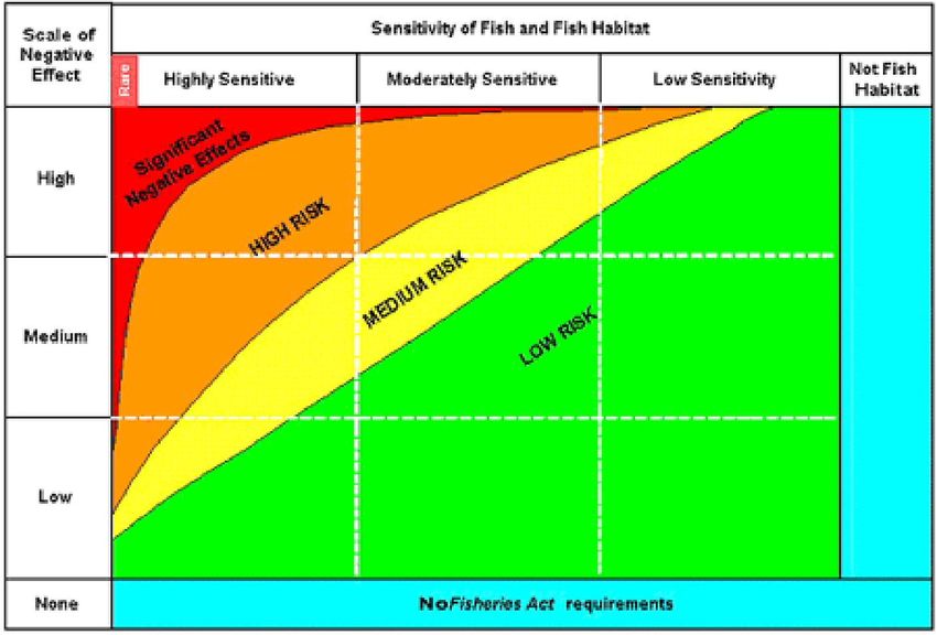
Windermere Lake –
Living Lakes Canada Foreshore Development Guide
Suggested Citation
Schleppe, J1. and McPherson, S.2 2021. Windermere Lake - Foreshore Development
Guide. Prepared for Living Lakes Canada. Prepared by Ecoscape Environmental
Consultants Ltd.1 and Lotic Environmental Ltd.2
Acknowledgements
This project would not have been realized without the assistance and contributions from
the following individuals:
Ryan Cloutier, Acting Project Manager, Living Lakes Canada
Bruce MacDonald, Project Director, Living Lakes Canada
Heather Leschied, Operations Director, Living Lakes Canada
This project was completed in coordination with:
Fisheries and Oceans Canada
Ministry of Forests, Lands, Natural Resource Operations and Rural
Development (FLNRORD)
Regional District of East Kootenay
District of Invermere
Foreshore Inventory and Mapping Technical Committee
iiWindermere Lake - Foreshore
Living Lakes Canada Development Guide
TABLE OF CONTENTS
Suggested Citation ....................................................................................................... ii
Acknowledgements ...................................................................................................... ii
1. Introduction ........................................................................................... 1
2. Important Contact Information ............................................................... 1
2.1. First Nations Traditional Ecological Knowledge ..................................... 2
3. FDG Process Overview ......................................................................... 3
3.1. Interpret the FDG Map........................................................................... 4
4. Step 1. Locate Project Relative to Shoreline Colour Zones and Zones of
Sensitivity .............................................................................................. 5
5. Step 2 – Review Colour Zone, ZOS and Conservation Recommendations
5
5.1. Shoreline Colour Zone Recommendations ............................................ 5
5.2. Comparison of results with the original FDG.......................................... 7
5.3. Zones of Sensitivity Recommendations ................................................. 8
5.3. Shoreline Conservation Recommendations ......................................... 18
6. Step 3. Refer to the Activity Risk Matrix (ARM) to Determine Project Risk.
18
6.1. Using the ARM .................................................................................... 19
6.2. General Mitigation Hierarchy ............................................................... 20
6.3. Very High and High Risk Activities....................................................... 20
6.4. Moderate and Low Risk Activities ........................................................ 21
7. Step 4 – Determine Regulatory Requirements and Submit Applications
21
7.1. Other Considerations to Facilitate Project Approvals ........................... 22
8. References .......................................................................................... 23
Figures
Figure 1. Four steps when planning to develop or modify foreshore habitat.................. 3
Figure 2. Zone of Sensitivity with an appropriate buffer. ............................................... 4
Figure 3. How the potential for negative effects relates to sensitivity and risk (DFO
2006). .............................................................................................................19
Figure 4. Typical Environmental Regulatory Review Decision-Making Process ..........21
Tables
Table 1. FHSI ecological rank and ZOS colour scheme applied to the FDG map. ........ 4
Appendices
Appendix A. Foreshore Guidance Document Map ...................................................... 26
Appendix B. Activity Risk Matrix (Risk ratings: NA = Not Allowed, VH = Very High, H =
High, M = Moderate, and L = Low) .................................................................. 27
Appendix C. Legal Requirements and Policy .............................................................. 33
Appendix D. Best Management Practices ...................................................................39
iiiForeshore Development
Living Lakes Canada Guide
1. Introduction
In recent years, environmental impacts to lake shorelines (e.g., degraded habitat, recreational
use conflicts, and water quality impacts) have prompted government agencies to initiate
projects focused on increasing our understanding of lake shorelines to support evidence-
based lake management strategies. For example, Windermere Lake is multi-jurisdictional and
lake management occurs at all levels (i.e., Local, Regional, Provincial, Federal, and First
Nations). The guidelines presented in this document are founded on the concept that
sustainable management is the shared responsibility of all stakeholders, including
proponents, professionals and all levels of government.
This Foreshore Development Guide (FDG) provides development planning guidelines, aimed
at protecting sensitive fish and wildlife species and their habitats identified through the
previous FIM and FHSI analyses provided in the Foreshore Integrated Management Planning
report (FIMP; Schleppe and McPherson 2021). The FDG is an initial tool used when planning
for, prescribing, or reviewing riparian and shoreline alterations. Based on the environmental
(species and habitat) values, the FGD identifies the levels of risk associated with shoreline
alteration from various types of development activities. The risks identify the anticipated
regulatory steps required to proceed with the project. The guidelines provide important
information to support both the landowner in preparing foreshore work applications, and the
government agencies during their review of the applications.
The FDG recommends areas to be conserved, where development may present very high or
significant risk to high value species and their habitats that require shoreline areas to carry
out their life-cycle. These sensitive habitats may be protected by various means, including
local government inclusion in local planning processes such as Official Community Plans
(OCP) and bylaws. Additionally, the FDG describes how restoration opportunities should be
sought to improve habitat previously disturbed, and to potentially aid in obtaining regulatory
support for new proposed projects.
The FDG methods were first developed, when completing the original Windermere Lake
study, by the East Kootenay Integrated Lake Management Partnership (EKILMP et al. 2009).
These original methods used the BC Ministry of Environment (BC MoE) document - High
Value Habitat Maps and Associated Protocol for Works along the Foreshore of Large Lakes
within the Okanagan (BC MoE 2008), and input from the various EKILMP members including:
Fisheries and Oceans Canada (DFO), BC MoE, Regional District of East Kootenay (RDEK)
and Wildsight. Additional lake projects followed and expanded on the initial EKILMP FDG.
Notable lake projects included: Moyie Lake (Schleppe 2009), Tie Lake (McPherson et al.
2012) and Kootenay Lake (Kootenay Lake Partnership 2019). With each iteration of these
documents, the general process for developing a FDG were refined. This FDG was developed
using the most recent template as a guide (McPherson and Schleppe 2020), with lake specific
modifications made as required.
2. Important Contact Information
Proponents may use the contact information provided below when planning their proposed
activities. Even with the use of this document, it is recommended that anyone who is planning
work on Crown Land (such as the shoreline), first contact FrontCounterBC or retain the
services of a Qualified Environmental Professional (QEP) who will contact FrontCounterBC
on their behalf. Depending on the situation, FrontCounterBC will provide guidance on whether
1Foreshore Development
Living Lakes Canada Guide
the proposed works are allowed or not allowed under the respective legislation. Similarly,
works on private lands must also consider local government’s requirements (e.g., permitting
or notifications).
FrontCounterBC - FrontCounterBC should be contacted for any works planned on Crown
Land, including work along the lake shoreline.
Phone: 1-877-855-3222
Email: FrontCounterBC@gov.bc.ca
Regional District – Regional District of East Kootenay should be contacted for any works
planned on private land within the region’s jurisdiction.
Phone: 250-489-2791
Email: info@rdek.bc.ca
Local Municipality – District of Invermere should be contacted for any works planned on
private land within the city’s jurisdiction.
Phone: 250-342-9281
Email: info@invermere.net
First Nations – The following should be contacted for any works that require First Nation
engagement.
Ktunaxa Nation Shuswap Indian Band
Phone: 250-489-2464 250-341-3678
Email: news@ktunaxa.org Website: http://www.shuswapband.net/
Lake Partnership Group – Lake Windermere Ambassadors
Phone: 250-341-6898
Email: info@lakeambassadors.ca
2.1. First Nations Traditional Ecological Knowledge
Our project team reached out to local First Nations and requested participation in field data
collection and/or inclusion of First Nations Traditional Ecological Knowledge (TEK) data. The
Ktunaxa Nation Council, Shuswap Indian Band, and Akisqnuk First Nations were contacted
in late July. The Shuswap Indian Band expressed their interest and participated in both the
field data collection (Basil Stevens) and provided TEK data. The other First Nations contacted
did not have the capacity to participate.
Basil Stevens was a valuable member of the field team. He assisted with photography and
modification counts. Basil also provided memories of growing up and recreating on the lake,
and other fish and wildlife insight including but not limited to where winter angling currently
occurs, and the presence of turtle habitat at Kinsmen park.
In regard to providing TEK, the Shuswap Indian Band provided point observations with details
such a Kokanee spawning locations or other wildlife, ecosystem, or habitat related data.
Overall, there was high degree of overlap with the data available in the scientific literature.
Sufficient detail was not provided to generate any one specific criteria, etc. Additionally, our
agreement to confidentiality was that we were limited in the specific data that could be
provided.
2Foreshore Development
Living Lakes Canada Guide
3. FDG Process Overview
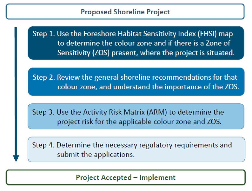
The FDG provides a step-wise process to help direct applicants through the initial planning
stages for their proposed shoreline development, project or activity (Figure 1).
Step 1: Identify the fish and wildlife habitat values where the
project is situated using the FDG map. The FDG map was For areas of greater
prepared using the FHSI outputs (Schleppe and McPherson risk, a very high level of
2021), and depicts: a) values by segment, with different detail is needed in order
colours representing high to low values; and b) where Zones to submit an application
of Sensitivity (ZOS) may be present. ZOS are areas with that can be considered
exceptionally high value, which should if at all possible, be for regulatory review. In
conserved according to local, provincial or federal plans or these cases, it should
through private land agreements. not be expected that
because information is
Step 2: Review the general recommendations for the
submitted that approvals
applicable colour zone and ZOS to understand associated
are forthcoming.
habitat sensitivity of the area, and risk anthropogenic
disturbances pose.
Step 3: Use the Activity Risk Matrix (ARM) to identify the level
of risk of the proposed project on the habitat. The risk is
indicative of the acceptability of a project to regulators.
Step 4: Determine the necessary regulatory approvals/permits/authorizations (collectively
‘approvals’) that must be obtained. This final step is project dependent and depends on many
factors and is subject to change based on government policy. Hence, only an overview is
provided here, along with logistical considerations.
Figure 1. Four steps when planning to develop or modify foreshore habitat.
3Foreshore Development
Living Lakes Canada Guide
3.1. Interpret the FDG Map
The key results of the FIM and FHSI are presented in tables and maps in the FIMP (Schleppe
and McPherson 2021). When planning foreshore development, the FDG map is the primary
reference tool because it synthesizes the pertinent fish and wildlife information into an easy
to understand map (Appendix A). In the FDG map, the FHSI ecological rankings for each
segment are depicted as one of five colours zones, ranging from very high to very low value
(Table 1).
Table 1. FHSI ecological rank and ZOS colour scheme applied to the FDG map.
Map
Value type Rank/Sensitivity
Colour
Very High Red
High Orange
Ecological Rank
Moderate Yellow
Low & Very Low Grey
Fisheries Blue
Zones of Wildlife Brown
Sensitivity
Waterfowl Teal
Ecosystem/Habitat Feature Green
The FDG map also depicts each ZOS in a specific colour scheme. Each ZOS is presented as
either a polygon, line, or point, and includes appropriate buffers. This buffer accounts for
unknowns of the ZOS full extent, and protects the core ZOS from potential impacts from
adjacent activities (Figure 2). Details on each ZOS, including how each was defined, and how
the buffers were determined are presented in Section 5.2.
ZOS core area
ZOS buffer
`
Figure 2. Zone of Sensitivity with an appropriate buffer.
4Foreshore Development
Living Lakes Canada Guide
4. Step 1. Locate Project Relative to Shoreline Colour Zones and Zones of
Sensitivity
Use the FDG map to identify the values present along or within their proposed development
area. Together, the FHSI colour zone and the ZOS mapped features provide a science-based
tool to guide development planning. The fish and wildlife value/risk and subsequent regulatory
review process are highest in red zones and areas with ZOS. Since these areas have the
highest natural value and are at greatest risk to shoreline alteration, they require the highest
level of on-going protection. The values/risk in the grey zones are lowest. Since there is
already likely significant impact from development in grey zones, future development is less
likely to cause negative impacts. The specific recommendations for each colour zone and
ZOS are provided in the next section.
5. Step 2 – Review Colour Zone, ZOS and Conservation Recommendations
For this step, review the recommendations for the respective colour zone and ZOS that aligns
with the proposed development. The summary tables below provide detail on the values
present, and identify how to potentially minimize impacts. Also, refer to the conservation
recommendations to see how your project may align with an area that has been identified as
a candidate for protection. Proposed development should adhere to these recommendations
to reduce impacts on sensitive fish and wildlife values. Opportunities for restoration or re-
development should be explored in any zone where work is proposed. See the complete FIMP
report for a full presentation of details on all of these topics (Schleppe and McPherson 2021).
5.1. Shoreline Colour Zone Recommendations
Red Shoreline
Defined by: Very High FHSI ecological rank.
FHSI Red zones account for 30% of the total shoreline length of 11,270 m.
summary:
Sensitivity Red shoreline areas have been identified as essential for the long-term
Summary: maintenance of fish and/or wildlife values through the FHSI analysis.
These areas are essential for fish and/or wildlife populations.
Recommen- Due to their high value (sensitive communities present), Red shoreline
dations: areas are recommended to have limited development to promote
conservation use (Section 5.3). Low impact water access recreation and
traditional First Nation uses are examples of acceptable activities in these
areas, while permanent structures or alteration of habitats are not.
Invasive aquatic plant removal is often acceptable, provided there is an
approved aquatic plant removal program, including trained personnel, and
appropriate permitting in place. Habitat restoration may be appropriate in
these areas, where applicable.
5Foreshore Development
Living Lakes Canada Guide
Orange Shoreline
Defined by: High FHSI ecological rank.
FHSI Orange zones account for 19% or 7140 m of the total shoreline length.
summary:
Sensitivity Orange shoreline segments have been identified as high value habitat
Summary: areas for fish and/or wildlife. These areas are comprised of relatively
natural undisturbed habitats and likely have ZOS present. These areas
are sensitive to development, continue to provide important habitat
functions, but may be at risk from adjacent development pressures.
Recommen- Proponents should consider moving high risk activities to other areas if
dations: possible, or pursuing activities that have lower associated risks. The lake
environment can benefit from having orange shoreline areas set aside to
contribute to the overall lake conservation area. The conservation options
identified in Section 5.3 would likely apply through most of the orange
areas, benefitting the lake. Restoration opportunities potentially exist in
these areas (see FIMP report recommendations).
Yellow Shoreline
Defined by: Medium FHSI ecological rank.
Lake Yellow zones account for 32% or 12,120 m of the total shoreline length.
summary:
Sensitivity These areas have experienced a moderate amount of development
summary: disturbance and pressures. Although these areas have been impacted to
some degree, they still are largely intact and habitat values remain
important.
Recommen- Development along Yellow shoreline areas would likely result in less of
dations: an impact, than along Red or Orange areas. However, activities should
incorporate protection of habitat features that remain, be well above the
high water mark, and and/or be situated outside of the riparian area.
Restoration may be an option in some areas that have experienced past
developments. Development may proceed for low risk activities provided
a Best Management Practice (BMP) or Regional Operating Statement
(ROS) is available and followed (Appendix B). High risk activities without
a BMP or ROS will require an environmental assessment from a QEP.
6Foreshore Development
Living Lakes Canada Guide
Grey Shoreline
Defined by: Low and Very Low FHSI Ecological Rank.
Lake Grey zones account for 18% or 6870 m of the total shoreline length.
summary:
Sensitivity Grey shorelines have a lower ecological ranking. However, they still may
summary: contain valuable habitats requiring some protection, such as aquatic or
riparian vegetation. Their importance as corridors to neighboring high
value areas should also be considered during development.
Recommen- Human development has been concentrated in these areas and has
dations: resulted in disturbances to the natural fish and wildlife habitat. Important
habitats do exist in degraded and developed areas, and at least minimal
standards are required to protect fish and wildlife habitat in the grey zone
areas. In keeping with the objective of concentrating development in areas
that are already disturbed or of low value, new developments may be
considered in these areas. Re-development will also be considered.
Proposals should incorporate fish and wildlife habitat restoration or
improvement features, where feasible and practicable. For example, a
retaining wall redevelopment may be moved back from the HWM and/or
incorporate re-vegetation or other fish and wildlife features in the design.
Obtain advice from a QEP for habitat restoration techniques.
5.2. Comparison of results with the original FDG
A direct comparison with the original assessment was not possible, given that the FHSI
techniques and definitions for determination of colour zone have changed (Table 2). However,
a few observations were as follows:
The extent of red colour zone shoreline decreased from the original assessment.
The combined orange and red zones were similar at 55% in the original study and
49% in this study.
The extent of yellow colour zones was also very similar between the two years of
study, and the grey was exactly the same.
There is an increase in the number of ZOS or what were formally known as Key Habitat
Areas.
Areas that were designated as Orange or Red zones in the original study that are found to
not be in this current study have not likely lost their protections. This is because the Activity
Risk Matrix now accounts for Zones of Sensitivity uniquely for each development activity
(see Section 6.1).
7Foreshore Development
Living Lakes Canada Guide
Table 2. Comparison of original (EKILMP et al. 2009) and current extent of each colour
zone.
Original Current
Colour
Zone % %
Definition Definition
shoreline shoreline
Very high or high
Red rank with key 49% Very high rank 30%
habitat area
Orange Key habitat area 6% High rank 19%
Very high and high
Yellow 27% Moderate rank 32%
rank
Moderate, low and
Grey 18% Low and very low 18%
very low rank
5.3. Zones of Sensitivity Recommendations
Nine types of ZOS were identified through the FHSI analysis. The ZOS with their
corresponding buffers are identified on the FDG map. For this step, use the map and identify
if the proposed development aligns with any of the mapped ZOS (use outer edge of buffer).
Then refer to the corresponding ZOS summary table(s) below for general information on the
values present and recommendations to reduce impacts. Development proposed in these
areas with the potential to impact the habitat may require possible Federal, Provincial, local
government, and/or First Nations approvals depending upon proposed activities and the
location of works. A QEP is recommended to be retained if development is proposed in or
adjacent to (i.e., a 30 m buffer) to help guide proposed development if avoidance is not
possible.
8Foreshore Development
Living Lakes Canada Guide
Fisheries – Known Kokanee Spawning Area
Lake The Province has identified Kokanee spawning habitat as high
summary: conservation value areas in the Rocky Mountain and Kootenay Lake
Forest District (Neufeld pers. comm. 2021, Chirico 2005). The most recent
Kokanee spawner counts upstream and downstream of the Athalmer
Bridge were 2,500 in 2009 and 2,000 in 2008 (K. Bray pers. comm. 2021).
Numbers have decreased with time in this area, with 15,000 spawners
reported in 1995 in gravel outcrops at the lake outlet 50 m upstream and
200 m downstream of the Athalmer Bridge (Oliver 1995). Oliver (1995)
also reported 1,500 Kokanee spawners in the lower 500 m of Windermere
Creek and 50 fish in the lower 50 m of Goldie Creek. Kokanee may also
utilize other shoreline areas for spawning. During the original Windermere
Lake FIMP for example, 30 spawning Kokanee were evident 200 m
upstream of the lake outlet along the cobble shoreline (McPherson and
Hlushak 2008).
Sensitivity Kokanee spawning habitat is important to the long-term viability of
summary: this species. It is limited to only select locations along the shoreline
where suitable conditions are present. These conditions include a
combination of appropriate gravel bed areas, and the presence of
upwelling or springs to keep the gravels clean and allow the eggs to
be oxygenated].
Recommen- These sensitive habitats are to be protected, with no permanent
dations: developments recommended both within and adjacent to the mapped
polygon areas. A buffer of 30 m is recommended.
9Foreshore Development
Living Lakes Canada Guide
Fisheries – Stream Confluence
Lake In addition to Kokanee and Burbot spawning habitat identified above,
summary: creek outlets provide potential rearing and staging habitat for other native
fish species. Adfluvial populations of Bull Trout have been reported in
Windermere and Salter creeks (Griffith 1994, and Bissett pers. comm.
2008). Rainbow Trout were present in Windermere Creek and possibly
Abel and Goldie creeks (Griffith 1994). No information was available on
adfluvial forms of Westslope Cutthroat Trout, although resident fish were
reported in Windermere Creek (Artech 2002, Griffith 1994). Creek mouths
are also important to wildlife. In recognition of these values, stream
confluences were mapped as ZOS. The larger tributaries had a 100 m
buffer applied (i.e., Goldie and Windermere creeks) and the smaller
tributaries had a 50 m buffer mapped. The weighting given to this ZOS
recognizes that stream confluences overlap with riparian and wildlife
corridors values, and at select streams the Kokanee and Burbot spawning
areas present.
Sensitivity Stream confluences are important for a variety of reasons. Small
summary: streams, determined by TRIM linework, were given a 50 m buffer.
Goldie and Windermere Creek were each given a 100 m buffer.
Recommen- These sensitive habitats should be considered during proposed
dations: developments that occur both within and adjacent to the mapped polygon
areas. A buffer of 30 m is recommended.
10Foreshore Development
Living Lakes Canada Guide
Fisheries – Native Mussel Beds
Lake Native mussels are considered a fish under the Federal Fisheries Act,
summary: they hold First Nations traditional ecological value, and many populations
are declining. Declines are largely the result of habitat loss or degradation.
Most mussel species have a complex life cycle involving a fish host, free
living form, and the more commonly observed mussel. Previous sampling
on Windermere Lake has found Anodonta californiensis/nuttalliana clade
(California/Winged Floater) mussels to be present (Moore and Machial
2007, McPherson 2020a and 2020b). The Anodonta species are
evidenced by their singular “finger-like” papillae. Mussel presence in the
original FIMP was noted in only a few sites (segments 11 and 16), and
these sites were included in the FDG. This FIMP identified that mussels
were present to a much greater extent around the lake. Marked points
were compiled into polygons where mussel presence was expected. Only
presence was used because mussel densities were not mapped.
Sensitivity Mussels, once established are not highly motile. For this reason, they are
summary: very susceptible to any form of lakebed disturbance. The areas identified
within this ZOS do not differentiate mussel density and more data could
be collected to identify highly important beds. Some inferences regarding
density can be made however, by the density of observation points in the
dataset.
Recommen- These sensitive habitats should be considered during proposed
dations: developments that occur both within and adjacent to the mapped polygon
areas. A buffer of 30 m is recommended.
11Foreshore Development
Living Lakes Canada Guide
Fisheries – Burbot Spawning and Rearing
Lake Burbot are considered a species of regional concern in the Columbia
summary: River system due to marked declines in their numbers (McPhail 2007). A
conservation strategy for the upper Columbia River Burbot population
(Golden to Columbia Lake) is anticipated to be developed, once the
outcomes of the Upper Kootenay River Burbot Conservation Strategy are
realized (East Kootenay Burbot Scientific Working Group [EKBSWG]
2019). In lakes and rivers, Burbot generally spawn in shallow depths (0 to
10 m) over a variety of substrates from silt and sand to coarse gravel and
cobble (McPhail and Paragamian 2000). At Windermere Lake, Burbot
historically spawned by the hundreds in weed beds at the Windermere
and Goldie creek mouths and other areas of the lake with macrophytes
(Westlope 2001). At Windermere Lake and other lakes in the East
Kootenays, peak spawning occurs in the middle of February (Arndt 2001,
EKBSWG 2019). Studies in Columbia and Windermere lake found
juvenile Burbot to be strongly associated with interstitial spaces in the
substrate. Shoreline with gravel and cobble substrates were the preferred
habitat for age 0 burbot, while older juveniles were associated with larger
substrates of cobble and boulders (Taylor 2001 and 2002). Where aquatic
vegetation was utilized, extensively branching species such as bushy
pondweed (Najas flexis) was preferred (Taylor 2001). The western
shoreline of Windermere Lake has been found to provide juvenile burbot
habitat (mean density was 4.5 age 0 burbot/100 m, and 0.6 age-1
burbot/100 m; Taylor 2002). For this reason, the outlets of Windermere
Creek and Goldie Creek, and shoreline with gravel/cobble habitat and low
%fines (Foreshore Development
Living Lakes Canada Guide
Wildlife – Avian Bank Nesting
Lake The Bank Swallow (Riparia riparia) is a Threatened species under the
summary: SARA, that has documented nesting sites along the shoreline of
Windermere Lake (Darvill 2021). Bank Swallows generally arrive at their
breeding grounds in North America during early spring and depart late
summer to midfall. Bank Swallows have high site fidelity if nests were
successful the previous year (BC CDC 2021, Darvill pers. comm.). At
Windermere Lake, nests were present in steep sand/gravel banks, near
the top of the bank, along the edge of the water. Due to their sensitivity,
known Bank Swallow nesting locations were masked. Known Bank
Swallow nests were valued higher than other general bank nesting
locations, which either had past nesting evidence or potential for nests for
Bank Swallows or other species. If a project is planned in an area marked
as having avian bank nesting, the QEP is to refer to the GIS database to
confirm if Bank Swallow nesting habitat is present, as this is where the
masked data resides for this sensitive species.
Sensitivity Nesting birds are protected under a variety of different pieces of
summary: legislation. Disturbance to active nest sites can possibly cause harm to
the birds themselves if actively nesting, or impact habitats if they are
altered due to the site fidelity.
Recommen- These sensitive habitats should be avoided with appropriate buffers if
dations: development is proposed that occur both within and adjacent to the
mapped polygon areas. as described by R. Darvill (pers. comm. 2021)
“Bank nesting birds are aerial feeders over Lake Windermere and on the
terrestrial landscape around colonies. When breeding, feeding sites have
been described as usually within 200 m of where young are fed, but this
distance may vary depending on availability of foraging areas and may be
up to 1 km away. Given that research has shown the feeding area to be
usually be within 200 m, a buffer of 200 m is recommended during the
nesting period”.
13Foreshore Development
Living Lakes Canada Guide
Waterfowl – Floating Nests
Lake Surveys in the Columbia Wetlands have documented Lake Windermere
Summary: as important bird habitat when compared to the rest of the Columbia
Wetlands ecosystem (Darvill 2019). Darvill (2019) summarized the
significance of Lake Windermere to birds, as follows "Bird data retrieved
from an online database indicates that 165 bird species have been
detected at Lake Windermere, with 17 of these species considered to be
at-risk.” The south end of the lake lies within the Columbia Wetlands
Wildlife Management Area (the WMA). As outlined by the Province of BC
(2021b), "The WMA was established for the conservation and
management of fish and wildlife habitats and landscape connectivity so
that the Columbia River Wetlands continues to function as a natural
floodplain ecosystem”. Several species of birds that make floating nests
were observed, including several grebes (e.g., Western Grebe
(Aechmophorus occidentalis, listed as Special Concern by COSEWIC).
Large wind and wave events or waves generated from boats can cause
nests to become submerged. For this reason, areas of possible nesting
were identified using the floating and emergent data sets, looking for
areas with large coverage such as the south end of the lake, where
nesting and foraging opportunities were most probable. All these areas
were digitized from the large expanses of floating and emergent
vegetation data collected in this study to inform areas most likely
important to waterfowl that nest using floating platforms. These data can
be spatially updated as more specific nesting survey data becomes
available, and these areas are only considered possible nesting locations.
Actual nesting may vary from data presented.
Sensitivity This ZOS is focused on identifying possible floating nesting site locations.
summary: Species that utilize floating nests are highly susceptible to nest loss
through wind and wave events or from wake generated by large boats.
Nesting birds are protected and this ZOS is intended to provide a
summary of the most probable nesting locations on the lake.
Recommen- These sensitive habitats should be avoided with appropriate buffers if
dations: development is proposed that occurs both within and adjacent to the
mapped polygon areas. A site-specific buffer should be developed based
upon known values.
14Foreshore Development
Living Lakes Canada Guide
Waterfowl – Migration Flyway
Lake As outlined by the Province of BC (2021b), “The WMA is an important
Summary: component of the Pacific Flyway, a waterfowl migration route stretching
from nesting areas on the Arctic Ocean to wintering grounds in South
America. The WMA is adjacent to the Columbia River, extending 180 km
from Canal Flats to the head of the Mica Reservoir, north of Donald”.
Darvill (2019) described that “The south end of the lake has consistently
had large concentrations of staging waterfowl during migration and had
the highest single day bird counts resulting from a regional coordinated
bird count (i.e. Columbia Wetlands Waterbird Survey). When compared
across 105 survey stations in the Columbia Wetlands, the south end of
Windermere Lake appears to contain the most important staging area
within the continuous wetlands ecosystem for at-risk grebe species, as
well as for other bird species such as American Coot. Creek mouths at
Windermere Lake are also important habitat for birds, especially for
migrating shorebirds.” The south end of the lake and the Windermere
Creek mouth (due to it being the largest tributary) were digitized to inform
areas most likely important to migrating waterfowl. These data can be
spatially updated as more specific waterfowl staging density data
becomes available. These areas are only considered possible locations
based upon data available using airphoto interpretation and associated
aquatic vegetation data collected in this study.
Sensitivity This ZOS is focused on identifying high value migration locations in the
summary: Pacific Flyway. These areas provided important habitat for migrating
waterfowl for forage, rest, and other requirements during migration
periods. More inventory is needed to identify key habitat areas, and it is
expected that this dataset may change over time as new data is collected.
Recommen- These sensitive habitats should be avoided with appropriate buffers if
dations: development is proposed that occurs both within and adjacent to the
mapped polygon areas. A site-specific buffer should be developed based
upon known values.
15Foreshore Development
Living Lakes Canada Guide
Ecosystem/Habitat Feature - Grasslands
Lake The following summarizes some of the unique and sensitive values
Summary: grassland ecosystems (Grassland Conservation Council of BC [GCCBC]
2018): “Grasslands cover less than one percent of the province. Their
rarity is largely due to loss or fragmentation of habitat. Where they remain,
grasslands are frequently impacted by other causes including: invasive
species, ranching/hay fields, industrial development grazing, recreation,
forest encroachment, and fire suppression. Many animals use grasslands
for at least parts of their life cycle, and most of BC’s species at risk are
found in the grasslands. In the Kootenay Region, grasslands provide high-
quality wildlife habitat, and in many areas provide critical ungulate winter
range. Much of the grassland area in the Rocky Mountain Trench is on
private land and is considered to be a rare or at risk ecosystem.”
Examples of mapped sensitive species that are associated with
grasslands along the shoreline of Windermere Lake are the American
Badger and Lewis’s Woodpecker. Lewis’s Woodpecker is listed as
Threatened federally (SARA Schedule 1, 2012), and Special Concern
provincially (blue listed), and has been documented utilizing grassland
habitat south of Goldie Creek (Province of BC 2021a). These high value
habitats were mapped using the RDEK Official Community Plan areas,
BC Provincial Grasslands layers, and Vegetation Resource Inventory
data. A composite layer was created using all data layers.
Sensitivity Grasslands are extremely fragile and susceptible to invasive species.
summary: Further, the provide forage, thermal and a variety of other important
functions for wildlife. Any significant ground disturbance can result in
establishment of invasive species. Additional ecosystem mapping could
be considered to determine if any coniferous woodlands or other habitats
should be considered in this ZOS.
Recommen- These sensitive habitats should be avoided with appropriate buffers if
dations: development is proposed that occurs both within and adjacent to the
mapped polygon areas. If development is proposed, key mitigation
strategies may be required, including avoidance, invasive species
management, or other strategizes depending where and what is
proposed.
16Foreshore Development
Living Lakes Canada Guide
Ecosystem/Habitat Feature – Connectivity Corridor
Lake Connectivity to habitat is important for wildlife immigration and emigration.
Summary: Connectivity and any specific habitat requirements to facilitate this
process varies by species. As outlined in the original FIMP (McPherson
and Hlushak 2008): “Foreshore areas are highly productive and diverse,
providing important foraging and refuge habitat for wildlife. They also
provide a critical link between aquatic and terrestrial ecosystems.
Maintaining the habitat and unrestricted access to upslope habitats is thus
important.” In accordance with the original FIMP and the RDEK OCP, this
ZOS includes connectivity corridors for wildlife in general, riparian habitat
of creeks, linkages for Badger movement and important high value
ungulate winter range (RDEK 2019 and McPherson and Hlushak 2008).
The badger linkage is provided by the BC Hydro right-of-way, Copper
Point Golf Course and Holland Creek drainage. The ungulate winter range
of note is located along the southwest facing slopes, and includes riparian
and shoreline areas. These original FIMP and OCP should be referenced
for further specifics by area. These high value habitats were mapped
using the RDEK Official Community Plan areas. Additional areas included
the mapped occurrence of Painted Turtle in Dorothy Lake in Kinsmen
Park. The Painted Turtle - Intermountain - Rocky Mountain Population is
listed as a species of Special Concern both federally (SARA Schedule 1,
2007), and provincially (blue listed) (Province of BC 2021b).
Sensitivity Connectivity corridors for wildlife are important. These corridors allow
summary: immigration and emigration to and from areas they require to carry out
their life cycle. Connectivity corridors identified in this ZOS are generally
consistent with previous guidance documents.
Recommen- These sensitive habitats should be avoided with appropriate buffers if
dations: development is proposed that occurs both within and adjacent to the
mapped polygon areas. If development is proposed, key mitigation
strategies may be required, including avoidance, invasive species
management, or other strategizes depending where and what is
proposed.
17Foreshore Development
Living Lakes Canada Guide
Ecosystem/Habitat Feature – Shore Wetlands
Lake Emergent shore wetlands were present in many areas of Windermere
Summary: Lake. These areas ranged from simple emergent bulrush areas to very
complex habitats with submergent, floating and emergent vegetation at
the south end of the lake identified in the WMA. There were also several
backwater wetlands identified, located behind rail fill that were likely
historically connected to the lake. Wetlands provide valuable fish and
wildlife habitats. For example, sampling during the original FIMP found
Mountain Whitefish fry in the vegetated/wetland habitat in Segment 25
(Cemetery/Hidden Bay shoreline area), and juveniles and subadults in the
wetlands at the south end of the lake (McPherson and Hlushak 2008).
Wetland areas were identified as all areas that were either mapped as
emergent or floating vegetation, and those that were in backwater
wetlands.
Sensitivity Wetlands are highly productive areas of lakes that are used for foraging,
summary: nesting and reproduction, cover and a variety of other life history
requirements for many species including but not limited to fish, wildlife,
waterfowl, and aquatic insect
Recommen- These sensitive habitats should be avoided with appropriate buffers if
dations: development is proposed that occurs both within and adjacent to the
mapped polygon areas. If development is proposed, key mitigation
strategies may be required, including avoidance, invasive species
management, or other strategizes depending where and what is
proposed.
5.4. Shoreline Conservation Recommendations
At this time, all remaining natural areas on Windermere Lake provide important habitat. Focus
in areas that are urbanized should be on achieving restoration during redevelopment.
Avoidance of natural areas that are more prevalent on the south and western ends of the lake
is important. The data in this study and others suggest that densification of natural areas is
likely of greatest risk to shoreline habitats that support fish and wildlife communities. The
FIMP technical report provides specific recommendations for local, Provincial, and Federal
Agencies to consider to aid in implementation of the FDG (Schleppe and McPherson 2021).
It is recommended that the Regional District of East Kootenay and District of Invermere be
consulted in regards to how these colour zone updates and ZOS can be best integrated into
their respective Windermere Lake Official Community Plans.
6. Step 3. Refer to the Activity Risk Matrix (ARM) to Determine Project Risk.
This step involves using the ARM to determine what the predicted level of risk is for your
specific proposed activity, given the shoreline colour zone and ZOS present. It is a well
understood concept that the potential for negative environmental impacts are deemed
greatest in areas where values and risk are highest (Figure 3; DFO 2006). In the ARM, each
18Foreshore Development
Living Lakes Canada Guide
colour zone and activity combination has been rated as having a risk of either: Very High
(VH), High (H), Moderate (M), or Low (L) (Appendix B). These risk ratings reflect the potential
impacts on fish and wildlife, with a Very High risk posing the greatest potential concern, and
the Low Risk a lower level of concern. The ARM also identifies that if a ZOS is present, the
risk also increases.
Figure 3. How the potential for negative effects relates to
sensitivity and risk (DFO 2006).
6.1. Using the ARM
Clarifications for using the ARM are listed below:
1. If your activity is not listed, assume High Risk and contact FrontCounterBC for
advice.
2. Where several activities with differing risk rating are proposed for a single Project,
the cumulative risk may increase. Consequently, it is recommended to seek the
advice of a QEP to determine if the higher of the two risk ratings effectively captures
the cumulative risk, or if the highest risk rating should be used [e.g., Very High]).
3. The ARM distinguishes between several activities above and below the present
natural boundary (NB). The NB is the legal term BC Crown Land Branch uses to
define the Crown Land property boundary along the shoreline. High Water Hark
(HWM) is a similar standard term used by DFO when considering impacts to fish
values. The NB and HWM are often located in the same location, but this can vary.
Only a registered BC Legal Land Surveyor may determine the NB.
4. In some instances, the project may not seem to have a high degree of risk. However,
the ARM also accounts for other accompanying impacts likely to occur once the
modification is in place. For instance, once a dock is in place, other likely associated
impacts are: prop wash, maintenance, and boat traffic.
19Foreshore Development
Living Lakes Canada Guide
6.2. General Mitigation Hierarchy
The general principles of shoreline development are to design in such a way that there is “No
Net Loss” in the quantity or quality of existing habitat. These principles are supported by the
federal and provincial policy1,2). In general, these principles are achieved through application
of the following mitigation options: (1) avoidance of environmental impacts and associated
components; (2) minimization of unavoidable impacts on environmental values and
associated components; (3) restore on site environmental values and associated
components, and, (4) offset impacts to environmental values of components for residual
impacts that cannot be minimized.
6.3. Very High and High Risk Activities
Most in-stream works in Red and Orange shoreline zone areas are considered Very High and
High Risk activities. All activities in a ZOS are considered Very High Risk. Development in
these areas has the potential to cause long-term or irreparable disturbance to the highly
sensitive/unique values present. The Very High Risk activities in particular, are known to have
significant challenges related to providing adequate mitigation to address the loss of fish
and/or wildlife habitat values. For example, the dredging activity is considered Very High Risk
in all colour zones, since it results in a major disturbance to the substrate, aquatic vegetation
that may be present, and has the potential for direct impacts on aquatic life, and processes
(wave climate and sediment transport). There may also be indirect impacts, such as on water
quality, if for example the dredge is to support a marina.
If your activity is identified as being Very High or High Risk, determine if you can modify the
activity or location to reduce the risk. This may involve moving the project to a colour zone
with less sensitive habitat, or selecting a lower risk activity (Figure 4). If reducing the risk is
not possible by re-designing or re-locating the project, there is a high likelihood that a detailed
environmental assessment would be required to support the project application. In these
areas, the high risks may trigger a request for a Harmful Alteration, Disruption or Destruction
of Fish Habitat (HADD) authorization under the federal Fisheries Act. If residual effects cannot
be mitigated, compensation may be required. Acceptable mitigation and compensation
measures would likely be very costly to implement. It is highly advised that a QEP be retained
to assist with the project planning in all high and very high risk areas. A QEP should be
knowledgeable about both the permitting and application process for proposed activities and
will be able to provide guidance on potential environmental risks and impacts. A QEP would
likely conduct an environmental assessment within the project area, confirm risks, and make
recommendations to reduce impacts to aid in the regulatory permitting process. Applications
for these types of developments may not be supported by regulators and may not be
approved, even if extensive and detailed information is provided as part of a permitting
process.
As an example, the type of information that might be required to support an application for a
proposed project located in a sensitive area could include, a detailed erosion control plan that
might require a BC Legal Land Surveyor to determine the location of NB and property
boundaries, a QEP to provide recommendations to mitigate construction works as part of an
1
DFO Projects Near Water website: https://dfo-mpo.gc.ca/pnw-ppe/index-eng.html
2
BC Environmental Mitigation Policy website:
https://www2.gov.bc.ca/gov/content/environment/natural-resource-stewardship/laws-policies-
standards-guidance/environmental-guidance-and-policy/environmental-mitigation-policy.
20Foreshore Development
Living Lakes Canada Guide
environmental assessment, or an engineer may be needed to provide a detailed design for
submission of permits under regulatory processes.
Figure 4. Typical Environmental Regulatory Review Decision-Making Process
Project Activity Risk
Very High or High risk1 Moderate or Low risk
Retain a QEP to prepare EA2 Determine if environmental
and submit with federal / protection guideline exists3
provincial applications
NO YES
Limited habitat values
Project declined - and/or impacts can be
unacceptable risk to successfully mitigated or
habitat Submit notifications as
compensated
required in guideline
Abandon project, propose Approval granted -
in a different colour zone, subject to compliance Proceed with Project subject
or propose a lower risk with terms and to terms and conditions
activity conditions
1
Very High or High Risk activities have the potential to raise significant concerns. These activities
have great challenges related to providing adequate mitigation or compensation to address the loss
of fish and/or wildlife habitat values, and could be costly to implement (may require compensation).
2
Environmental Assessment
3
BMP – Best Management Practice; ROS –Regional Operating Statement
6.4. Moderate and Low Risk Activities
With appropriate design and planning, Moderate and Low Risk activities could be
incorporated along the foreshore with fewer impacts on fish and wildlife habitat values. Where
available, these activities should follow applicable Best Management Practices (BMP),
Standards and Codes of Practice (collectively BMP; see next section). Where BMPs are not
available, or a deviation from the BMP is proposed, a QEP should be retained to complete
the application. The application will be reviewed by the applicable agencies.
7. Step 4 – Determine Regulatory Requirements and Submit Applications
The final step when planning a foreshore development project is to determine the regulatory
requirements necessary for the project to proceed and to submit those applications.
Regulatory applications are to be made to the federal, provincial, or local governments for
necessary permits, authorizations, notifications, and reviews etc. Essentially any shoreline
development will require the preparation of at least one regulatory application. The regulatory
21Foreshore Development
Living Lakes Canada Guide
application’s acceptance will be required for the project to proceed legitimately. Commencing
work without approval may be considered unlawful and result in infractions such as trespass.
Work that has not been approved may also be subject to enforcement actions by the
respective agencies, and may require additional effort to mitigate any undesired
environmental impacts that occurred. Alternatively, the project proponent could be required
to remove all infrastructure and restore the area.
Typical regulatory requirements for each activity
listed in the ARM are provided in Appendix C.
As well, Provincial BMPs have been listed in This document does not provide a full
Appendix D3 . Although summarized here, the summary of all potential requirements for
requirements at the time of planning the project a particular project. Proponents must
will need to be confirmed, as regulatory ensure that they have adequately
changes might occur. Also, the DFO website considered, consulted, and determined
should be reviewed for applicable Standards the necessary approvals required for a
and Codes of Practice that may help guide project to proceed prior to undertaking any
planning and development 4 . Contact works.
FrontCounterBC to determine which provincial
permits, approvals or authorizations you need,
or retain a QEP for guidance.
7.1. Other Considerations to Facilitate Project Approvals
This FDG addresses both existing and proposed works. Sometimes there are concerns with
the installation of past structures, which may include, if the structures:
Resulted in extensive impacts along the shoreline;
Were installed without appropriate permits or approvals in place; and/or,
Were not compliant with standard BMPs.
If any of the above concerns are present on the property where work is planned, then follow
these steps, so that new applications, or applications for maintenance or expansion on
existing projects, can be reviewed more effectively:
1. Determine if the existing works are on private land or Crown Land.
2. Determine if they are located in an Application Only Area/Reserve area established
under the Land Act.
3. Determine if the works were authorized by the appropriate authority. If yes, skip to
step 5.
4. Seek approval from the appropriate authority. Approval may or may not be granted
depending on the situation. Previous projects installed without appropriate permits
or approvals may be required to be removed as part of an application process.
5. Plan and update existing works to current Best Management Practices.
6. Include other mitigation practices, such as landscape restoration (planting native
riparian vegetation), substrate improvement (removing or mitigating existing
groynes), and other habitat improvements.
3
A current list of provincial BMP’s are available at:
https://www2.gov.bc.ca/gov/content/environment/natural-resource-stewardship/laws-policies-
standards-guidance/best-management-practices
4
DFO Project Near Water website: https://www.dfo-mpo.gc.ca/pnw-ppe/index-eng.html
22Foreshore Development
Living Lakes Canada Guide
8. References
Artech Consulting Ltd. 2002. Reconnaissance (1:20,000 Fish and Fish Habitat Inventory of
the Stoddart Creek, Shuswap Creek, Bornais Creek and Windermere Creek
Watersheds. Consultant Report prepared for Slocan Forest Products, Radium
Division.
B.C. Conservation Data Centre. 2009. Species Summary: Riparia riparia. B.C. Ministy of
Environment. Available: https://a100.gov.bc.ca/pub/eswp/ (accessed Feb 18, 2021).
BC Ministry of Environment (BC MOE). 2008. High value habitat maps and Associated
protocol for works along the foreshore of large lakes within the Okanagan, Region 8.
Government memorandum.
BC MOE. 2019. Natural Resource Best Management Practices. Retrieved from
https://www2.gov.bc.ca/gov/content/environment/natural-resource-stewardship/laws-
policies-standards-guidance/best-management-practices
Chirico A. 2005. High Conservation Value (HCV) Fisheries Watersheds in the Rocky Mountain
and Kootenay Lake Forest District. Ministry of Sustainable Resource Management,
Fisheries Information Specialist, Nelson BC.
Darvill, R. 2021. Columbia Valley Swallow Project - 2020. Consultant report prepared by
Goldeneye Ecological Services, for Wildsight Golden.
Darvill, R. 2019. Insight into the Waterbirds of Lake Windermere. Consultant report prepared
by Goldeneye Ecological Services, for Lake Windermere Ambassadors.
DFO. 2006. Habitat Management Program: Standard Operating Policies.
East Kootenay Burbot Scientific Working Group (EKBSWG). 2019. Upper Kootenay River
Burbot Conservation Strategy. Prepared by Westslope Fisheries Ltd., Cranbrook, B.C.
61 pp. Prepared for Fish and Wildlife Compensation Program (Project Number: UKE-
F19-F-2734), the Ministry of Forests, Lands, Natural Resource Operations and Rural
Development, and the Ktunaxa Nation Council.
East Kootenay Integrated Lake Management Partnership (EKILMP), McPherson S. and
Hlushak D. 2009. Windermere Lake Shoreline Management Guidelines for Fish and
Wildlife Habitats. Combined agency and consultant (Interior Reforestation Co. Ltd)
report.
Grassland Conservation Council of BC (GCCBC). 2018. Website. Available:
bcgrasslands.org.
Griffith R.P. 1994. A Reconnaissance Survey of Windermere Lake. Consultant report
completed for Mica Fisheries Compensation Program, B.C. Hydro /B.C. Environment,
Nelson BC.
Kootenay Lake Partnership. 2019. Kootenay Lake Shoreline Management Guidelines – A
Living Document (Version 9). Prepared by: Ktunaxa Nation Council; Regional District
of Central Kootenay; Ministry of Forests, Lands and Natural Resource Operations;
Ecoscape Environmental Consultants Ltd.; Tipi Mountain Eco-Cultural Services Ltd.;
The Firelight Group Ltd.; and, Wayne Choquette.
23Foreshore Development
Living Lakes Canada Guide
McPhail, J.D. 2007. The Freshwater Fishes of British Columbia. Published by the University
of Alberta Press, Edmonton, Alberta.
McPhail J.D. and V.L. Paragamian. 2000. Burbot Biology and Life History. Pages 11-24. An
offprint prepared for Burbot: Biology, Ecology and Management edited by Vaughn L.
Paragamian and Dave W Willis. Publication Number 1: Fisheries Management Section
of the American Fisheries Society.
McPherson, S. 2020a. Timber Ridge Marina Dredge – Environmental Assessment &
Environmental Management Plan (Version 4). Prepared by Lotic Environmental Ltd.
for the Timber Ridge Property Owners Association and Terridian Utilities.
McPherson, S. 2020b. Indian Beach Estates Marina Dredge – Environmental Assessment &
Environmental Management Plan. Prepared by Lotic Environmental Ltd. for the Indian
Beach Estates Management Corporation (IBEMC).McPherson, S.1 and J. Schleppe2.
2020. Foreshore Development Guide – Template Report. Prepared for Living Lakes
Canada. Prepared by: Lotic Environmental Ltd.1, and Ecoscape Environmental
Consultants Ltd.2
McPherson1 S.M., D.G. Paton2 and M.D. Robinson1. 2012. Tie Lake Shoreline Management
Guidelines of Fish and Wildlife Habitats. Consultant report prepared for Ministry of
Forests Lands and Natural Resource Operations, Nelson BC. Prepared by Lotic
Environmental Ltd1, Anatum Ecological Consulting Ltd2.
McPherson, S.M. and D. Hlushak. 2008. Windermere Lake Fisheries and Wildlife Habitat
Assessment. Consultant report prepared for the East Kootenay Integrated Lake
Management Partnership. Prepared by Interior Reforestation Co. Ltd., Cranbrook, BC.
Moore A., and L. Machial. 2007. BC Conservation Corps Invertebrates at Risk Crew
Freshwater mussel surveys (target species Gonidea angulata) in the Okanagan and
Kootenay regions, summer 2007.
Oliver G.G. 1995. Kokanee Spawner Distribution Survey and Stock-Monitoring Plan for the
Upper Columbia Basin. Prepared for the Columbia Basin Fish and Wildlife
Compensation Program, Nelson BC, Canada. 62 pp + 2 App.
Province of BC. 2021a. BC Species and Ecosystems Explorer. B.C. Available:
https://www2.gov.bc.ca/gov/content/environment/plants-animals-
ecosystems/conservation-data-centre.
Province of BC. 2021b. Columbia Wetlands Wildlife Management Area. Available:
https://www2.gov.bc.ca/gov/content/environment/plants-animals-
ecosystems/wildlife/wildlife-habitats/conservation-lands/wma/wmas-list/columbia-
wetlands-visitor-use
Schleppe, J. 2009. Moyie Lake Foreshore Inventory and Mapping. Ecoscape Environmental
Consultants Ltd. Prepared for: East Kootenay Integrated Lake Management
Partnership.
Schleppe, J.1, and S. McPherson2. 2021. Windermere Lake Foreshore Integrated
Management Planning. Prepared for Living Lakes Canada. Prepared by: Ecoscape
Environmental Consultants Ltd.1, and Lotic Environmental Ltd.2
Schleppe, J.1, S. McPherson2, L. Porto3, and B. Mason4. 2020. Foreshore Integrated
Management Plan Methods. Prepared for Living Lakes Canada. Prepared by:
24You can also read