VTS Prince William Sound User's Manual - April 2014 Edition - User's Manual Vessel Traffic Service Prince William Sound
←
→
Page content transcription
If your browser does not render page correctly, please read the page content below
VTS Prince William Sound User’s Manual – April 2014 Edition

                   U.S. Coast Guard
              Vessel Traffic Service
              Prince William Sound

              User’s Manual
                         Tenth Edition
                          April 2014

                              1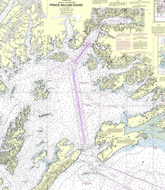
VTS Prince William Sound User’s Manual – April 2014 Edition

                          Notes

                             2
VTS Prince William Sound User’s Manual – April 2014 Edition

Purpose of this Manual:
With the implementation of Vessel Traffic Management regulations contained in Title 33, Code of
Federal Regulations, effective October 13, 1994, a VTS User’s Manual is required for Prince William
Sound. This manual provides the VTS User with:

•   An understanding of the regulations governing the Vessel Traffic Service contained in 33 CFR 161
    and 165.

•   A description of traffic management measures employed and services provided by the VTS.

•   A quick reference guide that describes the requirements and procedures for participating in Vessel
    Traffic Service Prince William Sound.

•   A copy of 33 CFR 161: Vessel Traffic Management Regulations.

Introduction:
Welcome to the Vessel Traffic Service Prince William Sound Area and thank you for taking the time to
read our User’s Manual. This Manual contains information that will help you use our service and
remain in compliance with applicable federal regulations and local operating requirements. Carrying
this manual satisfies the requirement found in 33 CFR 161 to keep a copy of the Vessel Traffic Service
rules on board when operating in the VTS Area. All mariners are encouraged to read this manual prior
to participating in the VTS.

Please call us any time at (907) 835-7205 if we can be of assistance. We look forward to working with
you!

Vessel Traffic Service Prince William Sound:

The Ports and Waterways Safety Act of 1972 (PWSA), as amended, authorizes the Coast Guard to
establish and operate Vessel Traffic Services. The Trans-Alaska Pipeline Authorization Act of 1973
amended the PWSA to specifically require the Coast Guard to establish and operate a Vessel Traffic
Service in Prince William Sound. A Coast Guard operated Prince William Sound Vessel Traffic Service
is also required in accordance with the Oil Pollution Act of 1990.

VTS Prince William Sound is a department of Coast Guard Marine Safety Unit Valdez, Alaska. The
VTS watch is housed in the Vessel Traffic Center, located in the Marine Safety Unit building in Valdez,
and is staffed 24 hours a day, 7 days a week by Coast Guard civilian and active duty personnel. Our
mission is to prevent accidents, loss of life, and damage to property and the environment. Our primary
function is to instill good order and predictability on the waters of the VTS Area by coordinating vessel
movements through the collection, verification, organization, and dissemination of information.

This version of the User’s Manual supersedes all previous editions. Copies of this manual are available
free of charge online at the U.S. Coast Guard Homeport web site: (homeport.uscg.mil/valdez).

                                                    3
VTS Prince William Sound User’s Manual – April 2014 Edition

                            Table of Contents

Concept of Operations……………………………………………………………                               5
Quick Reference Guide to VTS Regulations and Procedures……………………            6
VTS Levels of Service……………………………………………………………                               6
VTS Management Activities...………………………….……………………….                          6
VTS Services……………………………………………………………….……..                                  7
VTS Boundaries………………………………………………………………….                                   7
Participation Requirements………………………………………………………                            8
Carriage of VTS Rules……………………………………………………………                               9
Communicating with the VTS……………………………………………………                            10
Sailing Plans………………………………………………………………………                                  10
Position Reports………………………………………………………………….                                10
Final Reports………………………………………………………………………                                  10
Changes to Sail Plans…………………………………………………………….                             11
VTS Reporting Points…………………………………………….......................              11
Automated Information System (AIS)……………………………………………                    11-12
Other Types of Reporting………………………………………………………….                           12
VTS Authority to Direct Vessel Movements……………………………………..                  13
VTS Special Areas………………………………………………………………...                           13-14
Ice Routing Measures…………………………………………………………….                              14
Deviations…………………………………………………………......................                    15
Safety Zones……………………………………………………….......................                  16
Security Zones……………………………………………………………………..                                17
Anchoring in the VTSA………………………………………………………….                              18

Reference Chartlets
     VTS Area…………………………………………………………………...                                19
     Valdez Narrows Special Area………………………………………………                       20
     Valdez Arm Special Area……………………………….…………………..                       21
      VTS Reporting Points………………….…………………...………………                       22

Federal Regulations……………………………………………………….………                             24
33CFR26: Bridge to Bridge Radiotelephone Act……….……………..……….              25
33CFR161: Vessel Traffic Management…………………………………………                      29

Rule 10 - International Regulations for the Prevention of Collisions
at Sea, 1972 (72 COLREGS)…………………………………………….…..……                       40-41

                                     4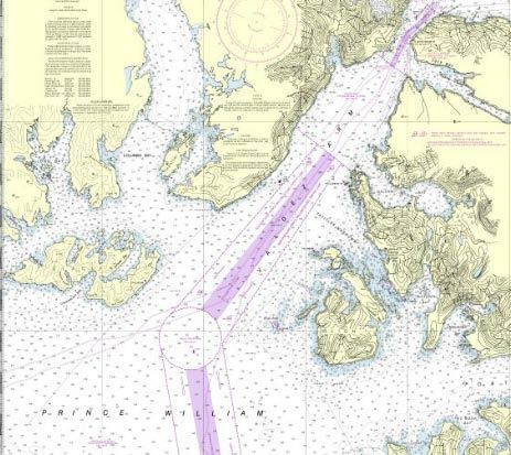
VTS Prince William Sound User’s Manual – April 2014 Edition

Concept of Operations
The primary components of the VTS are:

•    The Vessel Traffic Center (VTC) housed at Marine Safety Unit Valdez.

•    Ports and Waterways Safety System (PAWSS) operator workstations in the VTC.

•    Vessel Traffic Service Area (VTSA).

•    Traffic Separation Schemes (TSS).

•    VTS VHF-FM communications network.

•    VTS Automated Identification System (AIS) surveillance system.

•    VTS radar surveillance system.

•    VTS closed circuit video surveillance system.

•    Knowles Head Anchorage.

•    Federal Vessel Traffic Management regulations contained in 33 CFR 161.

•    Local VTS operating policies and procedures outlined in this manual.

The Traffic Separation Schemes in Prince William Sound have been adopted by the International
Maritime Organization (IMO). Because of this, they are subject to the provisions of Rule 10 of the
International Regulations for Prevention of Collisions at Sea, 1972 (72 COLREGS). The traffic lanes
and separation zone, which comprise each TSS, are depicted on nautical charts.

Vessel tracking in the Prince William Sound Vessel Traffic Service Area falls into four categories:

a)   Vessels in the radar coverage area.
b)   AIS equipped vessels in the radar coverage area.
c)   Vessels outside the radar coverage area.
d)   AIS equipped vessels outside the radar coverage area.

Vessels in the radar coverage area are tracked by radar returns and voice reports. AIS equipped vessels
in the radar coverage area are tracked by their AIS transponder updates (accurate to within 10 meters),
radar returns, and voice reports. Vessels outside the radar coverage area are tracked by their voice
reports, and if equipped, by their AIS.

                                                     5
VTS Prince William Sound User’s Manual – April 2014 Edition
VTS Prince William Sound - Quick Reference Guide
This section is for quick reference only. Information provided in this section is not intended to
modify the regulations in any respect. The applicable regulation should be referenced for more
detailed information.
• What are the VTS levels of service?
The International Association of Marine Aids to Navigation and Lighthouse Authorities (IALA) has
developed three levels in determining the service provided by a VTS. VTS Prince William Sound is
organized and equipped to provide all three levels of service.
Information Service: Provides the position, intentions, and destinations of vessels operating with the
VTS Area. It may also provide information on meteorological and hydrological conditions, status of
aids to navigation, traffic congestion, and waterways restrictions.
Navigation Assistance Service: Designed to assist in a vessel’s bridge team in the navigational decision
making process. This service is provided at the request of a vessel or when deemed necessary by the
VTS. Navigation Assistance Service provides essential and timely navigational information and may
inform, advise, and/or instruct vessels accordingly. This service in no way absolves the mariner of their
responsibility to act in a safe and prudent manner. The VTS will never direct a course to steer or engine
orders to be executed, but, instead, direct a desired outcome to the bridge crew (ex: “You are directed to
remain south of 61 degrees north until the tanker clears the southern boundary of the Valdez Narrows.”)
Traffic Organization Service: Provides advance planning of vessel movements and is particularly useful
during time of congestion or waterways restrictions. Monitoring traffic and enforcing adherence to rules
and regulations are integral parts of the Traffic Organization Service. The service may include
prioritization of movements, allocation of space, mandatory position reporting, established routes, speed
limits, ice routing measures, weather closures, and other measures that may be considered necessary and
appropriate by the VTS.
• What are the VTS management activities?
Monitor: VTS uses surveillance and communications equipment, as well as other resources to collect,
organize, display, and analyze information.
Inform: VTS uses communication resources to disseminate information to vessel operators, shore side
facilities, and other organizations to facilitate vessel traffic movements, safety, and security.
Recommend: VTS uses communication resources to highlight particular conditions or recommend
particular action to vessel operators, shore side facilities, and other organizations. Recommendations are
usually given to resolve miscommunications or otherwise call attention to particular circumstances,
hazards, or conflicts when there is doubt that vessels are taking appropriate action.
Direct: VTS employs communications resources to direct a course of action when necessary to minimize
the risk of collision or damage to property or the environment and to promote compliance with
navigation regulations.
6VTS Prince William Sound User’s Manual – April 2014 Edition
• What common services are provided by the VTS?
Caution: Information provided by VTS Prince William Sound is, to a large extent, based upon reports
from participating vessels and can be no more accurate than the information received. The Coast
Guard may not be aware of all hazardous circumstances within the VTS Area, and unreported
hazards may confront the mariner at any time.
VTS Prince William Sound may issue “traffic advisories” on VHF-FM Channel 13 or provide
information upon request on reported conditions within the VTS Area, such as:
o Hazardous conditions or circumstances.
o Traffic density.
o Environmental conditions, including weather and ice.
o Status of aids to navigation.
o Anticipated vessel encounters, including vessel name, type, position, hazardous
vessel operating conditions if applicable, and intended navigation movements, as reported.
o Temporary measures in effect (i.e. temporary safety zones, ice routing measures information,
weather closures, etc.).
o A description of local maritime operations and conditions, such as dredging or training exercises.
o Anchorage availability and berth or pilot station information.
o Other information or notification of special circumstances. [33 CFR 161.10]
• What are the boundaries of the PWS Vessel Traffic Service Area (VTSA)?
The Prince William Sound VTSA encompasses the same area as the Prince William Sound Regulated
Navigation Area. The VTSA is defined as:
"The navigable waters of the U.S., north of a line drawn from Cape Hinchinbrook Light to
Schooner Rock Light, comprising that portion of Prince William Sound between 146-30'W and
147-20'W and includes Valdez Arm, Valdez Narrows, and Port Valdez." [33 CFR 161.60 and
165.1704]
7VTS Prince William Sound User’s Manual – April 2014 Edition
• Who is required to participate in the VTS and what are they required to do?
VMRS User: The following vessel types are categorized as Vessel Movement Reporting System Users
(VMRS Users): [33 CFR 161.16]:
o Every power driven vessel of 40 meters (131.2 feet) or more in length, while navigating.
o Every towing vessel of 8 meters (26.2 feet) or more in length, while navigating
o Every vessel certificated to carry 50 or more passengers for hire, when engaged in trade.
VMRS Users are required to fully participate in the VTS in accordance with [CFR 33 161] and make the
following reports when applicable: a Sailing Plan, Position Reports, and Final Report.
VMRS Users, also considered VTS Users, must meet all requirements for VTS Users outlined below.
VTS User: Vessels that do not meet the criteria of a VMRS User, but fall into one of the following
categories (those subject to the Vessel Bridge-to-Bridge Radiotelephone Act [33 CFR 26]), are
designated as Vessel Traffic Service Users (VTS Users)
o Every power driven vessel of 20 meters or more in length, while navigating.
o Every vessel of 100 gross tons and upward and carrying 1 or more passengers for hire, while
navigating.
o Every towing vessel of 26 feet or over in length while navigating;
o Every dredge and floating plant engaged in operations in or near a channel or fairway that are likely
to restrict the navigation of other vessels, except for an unmanned or intermittently manned floating
plant under the control of a dredge.
VTS Users, whether underway or at anchor, are required to participate within a VTSA. [33 CFR 161.2
and 161.3]
Each VTS User must have radiotelephone equipment on board capable of operation from the vessel’s
navigational bridge (or a dredge's main control station) and maintain a listening watch on the prescribed
VTS frequency (Channel 13, 156.65 MHz). [33 CFR 161.12, 26.03 (b) (f), 26.04, and 161.18]
*Note: Tankers and tank vessels of 20,000 deadweight tons or more, while navigating in the VTSA, must have at least
2 radiotelephones capable of operating on the VTS frequency, one of which is capable of battery operation. A single
VHF-FM radio capable of scanning, or with "dual watch" capability, will not meet the requirement for two radios.
[33 CFR 165.1704 (c) (2)]
VTS Users must be able to communicate in the English language and respond promptly when hailed.
[33 CFR 26.07 and 161.12]
Other Vessels: Vessels that do not meet the criteria of a VTS User (i.e. small recreational vessels or
some commercial fishing vessels) are required to abide by the International Regulations for the
Prevention of Collisions at Sea, 1972 (72 COLREGS).
Any vessel underway in the VTSA may be required to participate to the extent that the VTS considers
necessary. [33 CFR 161.2, 161.3, 161.11, 161.12, 26.03 and 26.05].
8VTS Prince William Sound User’s Manual – April 2014 Edition
• Who must carry the VTS rules on board?
All VMRS and VTS Users are required to carry the VTS rules on board the vessel and maintain them for
ready reference. Carrying the VTS Prince William Sound User's Manual on board meets that
requirement. The VTS rules are also contained in the U.S. Coast Pilot. [33 CFR 161.4]
• How do I communicate with the VTS?
VTS Prince William Sound’s working frequency is Channel 13 VHF-FM (156.65 MHz), which is also
the Bridge-To-Bridge navigational frequency for Prince William Sound. Channel 13 is used because the
volume of radio traffic does not warrant use of a separate designated frequency.
Our call sign is "Valdez Traffic," and after communications are established, this may be shortened to
"Traffic." [33 CFR 26.03, 161.12 and 161.18]
Vessels unable to contact the VTS via radio may contact us via telephone at (907) 835-7205.
• Requirements for a Sailing Plan, Position Report, and Final Report.
The following reporting requirements apply to all VMRS Users:
a) Sailing Plan: - Unless exempt, at least 15 minutes prior to navigating in the VTSA, a VMRS User
must report:
o Vessel name and type.
o Current Position.
o Destination and estimated time of arrival (ETA).
o Intended route.
o Time and point of entry into the VTSA.
o Dangerous cargo on board or in tow as defined by 33 CFR 160.204 and other required
information as set out in 33 CFR 160.206, if applicable.
o Confirmation that the vessel has a copy of the VTS Prince William Sound rules onboard.
Additionally, tankers of 20,000 deadweight tons or more must also provide:
o Compliance with Navigation Safety Regulations contained in 33 CFR 164.
o Next and last port of call.
o Drafts.
o Pilotage.
Additionally, towing vessels must also provide:
o Length overall (with tow).
o Name and status of barges (loaded or empty).
o Towing configuration.
o Drafts.
o Cargo.
o Next and last port of call.
9VTS Prince William Sound User’s Manual – April 2014 Edition
*NOTE #1: All vessels that provide a Sailing Plan to the VTS prior to entering the VTSA at Cape Hinchinbrook are
encouraged to call 3 hours prior to arrival at Cape Hinchinbrook. Tankers are required to call 3 hours prior to
arrival at Cape Hinchinbrook in accordance with the Vessel Escort and Response Plan (VERP). Sailing Plans
reported by vessels 3 hours prior to arrival at Cape Hinchinbrook will provide for an opportunity to exchange
weather reports, information on ice conditions and anchorages, and to coordinate traffic management at Cape
Hinchinbrook and elsewhere in the VTSA.
Example Sailing Plan:
"Valdez Traffic, this is the tanker Polar Resolution, bound for Alyeska Valdez Marine Terminal.
We are in position 59 degrees, 55 minutes north, 146 degrees, 20 minutes west. Last port of call
was Ferndale, WA. Next port of call is Anacortes, WA. ETA to Cape Hinchinbrook is 0200.
ETA to Bligh Reef Pilot Station is 0500. We will be using the traffic lanes. The vessel has no
impairments. Our deepest draft is 10 meters. The Master has pilotage. We have a copy of the
VTS User’s Manual on board and the vessel is in compliance with 33 CFR 164."
b) Position Report: - A vessel must report its name and position:
o Upon point of entry into the VTSA.
o At designated reporting points as set forth in 33 CFR 161.60.
o When directed by the VTS. [33 CFR 161.20]
*NOTE: Notice of temporary reporting points, if established, may be published via general VTS traffic advisory,
Local Notice to Mariners, or in the VTS User's Manual.
Example Position Reports:
"Valdez Traffic, this is the tug Nanuq. We are inbound abeam Naked Island."
"Valdez Traffic, this is the Polar Endeavour, inbound abeam Rocky Point."
c) Final Report: - A vessel must report its name and position:
o On arrival at final destination; or
o When departing the VTSA. [33 CFR 161.22]
*NOTE: The VTS may also direct a vessel to provide any of the information set forth in the IMO Standard Ship
Reporting System, 33 CFR 161.18. [33 CFR 161.15 through 161.23]
Exempt VMRS Users: The following VMRS Users are considered exempt from providing position and
final reports due to the nature of their operations:
o Vessels operating on a published route and schedule;
o Vessels operating within an area of a radius of three nautical miles or less; or
o Vessels escorting or assisting another vessel in maneuvering positions.
Exempt vessels are required to provide a sail plan, but may do so at least five minutes, but not more than
15 minutes prior to navigating within the VTSA. If these vessels depart from their promulgated
schedule by more than 15 minutes or there is a change to their operating area they are no longer exempt
from providing position and final reports. The VTS may also direct exempt VMRS Users to provide
position and final reports when needed.
10VTS Prince William Sound User’s Manual – April 2014 Edition
• What if my plan changes?
A vessel must report to the VTS as soon as practicable:
o Any significant deviation from its Sailing Plan, as defined in [33 CFR 161.19], or from
previously reported information; or
o Any intention to deviate from a VTS issued measure or the vessel traffic routing system. [33
CFR 161.18]
• What are the designated voice reporting points for VTS Prince William Sound?
Reporting points for northbound vessels are:
1A – Cape Hinchinbrook
2A – Naked Island
3A – Bligh Reef (pilot embarkation point)
4A – Rocky Point
5 – Entrance Island
Reporting points for southbound vessels are:
5 – Entrance Island
4B – Rocky Point
3B – Bligh Reef (pilot debarkation point)
2B – Naked Island
1B – Schooner Rock
*NOTE 1: For exact positions of the above locations, see table 33 CFR 161.60 (d)
*NOTE 2: Vessels not equipped with AIS are directed to make positional calls when passing those points listed above.
*NOTE 3: Vessels equipped with operating Automated Identification System (AIS) are not required to make voice
radio position reports at designated reporting points as required by 33 CFR 161.21, unless otherwise directed by the
VTS. [33 CFR 161.21 and 165.1704]
• Who is required to have Automatic Identification System (AIS) in PWS?
o Self-propelled vessels of 65 feet or more in length, other than passenger and fishing vessels, in
commercial service and on an international voyage.
o Passenger vessels, of 150 gross tonnage or more.
o Tankers, regardless of tonnage.
o Vessels, other than passenger vessels or tankers, of 300 gross tonnage or more.
o Self-propelled vessels of 65 feet or more in length, other than fishing vessels and passenger vessels
certificated to carry less than 151 passengers-for-hire, in commercial service.
o Towing vessels of 26 feet or more in length and more than 600 horsepower, in commercial service.
o Passenger vessels certificated to carry more than 150 passengers-for-hire. [33 CFR 164.46]
11VTS Prince William Sound User’s Manual – April 2014 Edition
• What if a vessel’s AIS is inoperative?
Should a vessel’s AIS become inoperative while navigating a VTSA, it should be restored to operating
condition as soon as possible, and, until restored the vessel must:
o Notify the VTS and request a verbal deviation;
o Make voice radio Position Reports at designated reporting points; and
o Make any other reports as directed by the VTS.
Should a vessel’s AIS become inoperative prior to getting underway in the VTSA, the vessel must notify
the Prince William Sound Captain of the Port and request a deviation prior to getting underway or
entering the VTSA [33 CFR 165.1704].
In addition tank vessel of 20,000 deadweight tons must report as directed by [33 CFR 165.1704].
• What other types of information must a vessel provide to the VTS?
The VTS may request other information from vessels from time to time, including, but not limited to:
o Weather reports.
o Ice conditions.
o Traffic conditions or approximate locations of other vessels.
o Hazards to navigation (ex: floating logs).
Example weather report:
“Valdez Traffic, this is the tug Attentive, currently abeam the Seals Rocks buoy. Winds are out
of the northwest at 10 knots. Seas are 3 feet. Visibility is unlimited.”
*NOTE: Position and extent of ice should be given in terms of geography and distance from local landmarks.
Example ice report:
“Valdez Traffic, this is the ferry Aurora. There’s a moderate concentration of growlers, bergy
bits, and brash from Point Freemantle to Finski Pt, crossing all lanes down to the Bligh Reef
Precautionary Area. Visibility is unlimited.”
As soon as possible, vessels shall notify the VTS of any of the following:
o A marine casualty defined in 46 CFR 4.05-1.
o Involvement in an allision or collision with a fixed or floating object.
o A pollution incident as defined in 33 CFR 151.15.
o A defect or discrepancy in an aid to navigation.
o A hazardous condition that may adversely affect the safety of a vessel, bridge, structure, shore
area, or the environment of any navigable waters of the United States as defined in 33 CFR
160.204.
o Improper operation of vessel equipment required by 33 CFR 164.
o A situation or incident involving hazardous materials as defined in 49 CFR 176.48.
o A hazardous vessel operating condition as defined in 33 CFR 161.2. [33 CFR 161.12 (c)]
12VTS Prince William Sound User’s Manual – April 2014 Edition
• VTS authority to direct vessel movements.
The VTS may issue directions or measures to enhance navigation or vessel safety, or to protect the
marine environment. Examples:
a) Designating temporary reporting points and procedures.
b) Imposing vessel operating requirements.
c) Establishing vessel traffic routing schemes.
d) During conditions of vessel congestion, restricted visibility, adverse weather, or other hazardous
circumstances, the VTS may control, supervise, or otherwise manage traffic, by specifying times of
entry, movement, or departure to, from, or within the VTSA. [33 CFR 161.11]
*NOTE: The owner, operator, charterer, master, or person directing the movement of a vessel is responsible at all
times for the operation and safe navigation of his/her vessel under all circumstances. Compliance with VTS rules or
with direction of the VTS is contingent upon the exigencies of safe navigation. [33 CFR 161.1(c)]
• Where are the VTS Special Areas?
Within the VTSA are VTS Special Areas, where special operating requirements apply. Two VTS
Special Areas in PWS include Valdez Narrows VTS Special Area and Valdez Arm VTS Special Area.
The Valdez Narrows VTS Special Area consists of the waters northeast of a line bearing 307° true from
Tongue Point (61°02'06''N, 146°40'00''W) and southwest of a line bearing 307° true from Entrance
Island Light (61°05'06''N, 146°36'42''W). [33 CFR 161.60 and 165.1704]
The Valdez Arm VTS Special Area consists of the waters of the Valdez Arm traffic separation scheme
(described in 33CFR 167.1703 of this chapter) and the waters northeast of a line drawn from shoreline to
shoreline through the points 60-58.04N, 146-46.52W and 60-58.93 N, 146-48.86W; and southwest of a
line of bearing 307 degrees True from Tongue Point at 61-02.10 N, 146-40.00 W.
• What operating requirements apply in all VTS Special Areas? (33 CFR 161.13)
A VTS User shall, if towing astern, do so with as short a hawser as safety and good seamanship permit.
A VMRS User shall:
o Not enter or get underway in the VTS Special Area without prior approval from the VTS (locally
referred to as “Narrows and Arm Clearance”).
o Not enter a VTS Special Area if a hazardous vessel operating condition or circumstance exists.
o Not meet, cross, or overtake any other VMRS User in the VTS Special Area without prior
approval of the VTS.
o Before meeting, crossing or overtaking any other VMRS User in the VTS Area, make safe
passing arrangements on VHF Channel 13. This requirement does not relieve a vessel of any
duty prescribed by the International Regulations for Prevention of Collisions at Sea, 1972 (72
COLREGS). [33 CFR 161.13]
13VTS Prince William Sound User’s Manual – April 2014 Edition
• Additional operating requirements for the Valdez Narrows VTS Special Area.
(33 CFR 161.60)
No VMRS User shall proceed north of 61°00'N without prior approval from the VTS. [33 CFR 161.60
(d) (1)].
Whenever a tank barge or tanker over 20,000 deadweight tons is navigating in the Valdez Narrows VTS
Special Area:
a) A northbound vessel shall remain south of 61°00'N until the VTS has granted permission to proceed.
b) A southbound vessel shall remain in Port Valdez east of 146°35'W and north of 61°06'N until the
VTS has granted permission to proceed. [33 CFR 161.60 (d)]
c) If in ballast, a tank vessel shall limit its speed to 12 knots. [33 CFR 165.1704]
d) If laden, a tank vessel shall limit its speed to 6 knots between Middle Rock and Potato Point, and 12
knots elsewhere in the VTS Special Area. [33 CFR 165.1704]
This does not apply to:
a) A vessel less than 1600 gross tons.
b) A towing vessel less than 8 meters in length.
c) A vessel performing duties as a vessel escort as described in 33 CFR 168.
• What are Ice Routing Measures?
Generally, ice calved from the Columbia Glacier may become a navigation concern and may impact
vessel traffic operating within the VTSA. Ice routing measures may be implemented when ice is
present.
Ice Routing Measures – One Way Zone. The area of the Traffic Separation Scheme (TSS) with
reported ice will become a one-way zone and vessels may use both lanes and the separation zone to
ensure safe transit in the area of ice. This measure applies to all VMRS Users.
Ice Routing Measures – Daylight Only Transits. Instituted during periods of reduced visibility (2NM
or less) when heavy ice concentrations are reported in the TSS. Daylight is defined as the hours
between morning and evening civil twilight. Prior to the conclusion of civil twilight, applicable vessels
must be clear of the area of ice. The one way zone remains in effect during daylight only transits. This
measure primarily applies to tank vessels, but may be expanded to include other vessels at the
discretion of the VTS.
Ice Routing Measures – Closures. The VTS will evaluate closing the TSS in the area of reported ice
during periods of heavy ice concentration and/or when vessels must deviate from the TSS or make
excessive course corrections to avoid ice within the TSS. When no safe passage through ice
concentrations can be found or concentrations pose hazardous navigation conditions that place vessels
in danger, the VTS will close the TSS. This measure primarily applies to tank vessels, but may be
expanded to include other vessels at the discretion of the VTS.
14VTS Prince William Sound User’s Manual – April 2014 Edition
• When may a vessel deviate from VTS measures or directions?
Subject to the demands of safe navigation, a VTS User shall comply with all measures established or
directions issued by the VTS. If, in a specific circumstance, a VTS User is unable to safely comply with
a measure or direction issued by the VTS, the VTS User may deviate only to the extent necessary to
avoid endangering persons, property or the environment. The deviation shall be reported to the VTS as
soon as practicable. [33 CFR 161.19]
• Reporting a deviation.
Requests to deviate from any provision in [33 CFR 161--Vessel Traffic Services] or from locally
established VTS policies and procedures due to circumstances that develop during a transit or
immediately preceding a transit may be made verbally to the VTS Director through the VTS watch.
Requests to deviate shall be made as far in advance as practicable. Upon receipt of the request, the VTS
Director may authorize a deviation if it is determined that, based on vessel handling characteristics,
traffic density, radar contacts, environmental conditions and other relevant information, such a deviation
provides a level of safety equivalent to that provided by the required measure or is a maneuver
considered necessary for safe navigation under the circumstances. A verbal request for deviation must
state the need and fully describe the proposed alternative to the required measure or regulation.
Requests to deviate from any VTS regulation or measure due to circumstances that develop
during or immediately preceding a transit may be made verbally to the VTS Director through the
VTS watch by radio, Channel 13 VHF-FM, or by phone, (907) 835-7205. Requests shall be
made as far in advance as possible.
Requests to deviate from any provision of [33 CFR 161--Vessel Traffic Service] or from locally
established VTS policies and procedures, either for an extended period of time or if anticipated
before the start of a transit, must be submitted in writing to the Captain of the Port, Prince William
Sound. Upon receipt of the written request, the Captain of the Port may authorize a deviation if it is
determined that such a deviation provides a level of safety equivalent to that provided by the required
measure or is a maneuver considered necessary for safe navigation under the circumstances. An
application for a deviation must state the need and fully describe the proposed alternative to the required
measure or regulation.
Requests to deviate from any navigation safety provision of [33CFR164 –Navigation Safety
Regulations] must be submitted to the Captain of the Port, Prince William Sound. The Captain of the
Port may authorize a deviation from Navigation Safety regulations if they determine that the deviation
does not impair the safe navigation of the vessel under anticipated conditions and will not result in a
violation of the rules for preventing collisions at sea. The application for deviation must state the need
and fully describe the proposed alternative to the required measure or regulation. [33 CFR 164.55]
Requests to deviate from any navigation safety regulation, or to deviate from a VTS regulation or
measure for an extended period of time or if such need is anticipated prior to the start of a transit,
must be submitted in to: Commander, Marine Safety Unit Valdez, P.O. Box 486, Valdez, AK
99686 or via telephone to the Marine Safety Unit Valdez Command Duty Officer (907) 831-
0236.
15VTS Prince William Sound User’s Manual – April 2014 Edition
• What is a Safety Zone?
A Safety Zone is a water area, shore area, or water and shore area to which, for safety or environmental
purposes, access is limited to authorized persons, vehicles, or vessels. It may be stationary and
described by fixed limits or it may be described as a zone around a vessel in motion. [33 CFR 165.20]
• What rules apply in a Safety Zone?
No person, vehicle, vessel or object may enter or remain in a Safety Zone unless authorized by the
Captain of the Port. [33 CFR 165.23]
Each person in a Safety Zone who has notice of a lawful order or direction shall obey the order or
direction of the Captain of the Port issued to carry out the purposes of 33 CFR 165, Subpart A,
Regulated Navigation Areas and Limited Access Areas. [33 CFR 165.23]
• Where are the Safety Zones in Prince William Sound? (33CFR 165.1701 and 33
CFR 165.1703).
Valdez Marine Terminal (VMT). The area within 200 yards of any waterfront facility at the Trans-
Alaska Pipeline Valdez Terminal complex or vessels moored or anchored at the Trans-Alaska Pipeline
Valdez Terminal complex.
Tank Vessels Arriving/Departing VMT. The area within 200 yards of any tank vessel maneuvering to
approach, moor, unmoor, or depart the Trans-Alaska Pipeline Valdez Terminal complex.
Ammunition Island (locally referred to as the Valdez Container Terminal). When a vessel carrying
ammunition is moored or anchored at Ammunition Island, the waters within the following boundaries
are a safety zone—the area within a radius of 1330 yards of Ammunition Island, centered on latitude
61°07′28″ N, longitude 146°18′29″ W.
Vessel Transiting to/from Ammunition Island. The area 200 yards off a vessel carrying ammunition
navigating the Vessel Traffic system from abeam Naked Island, maneuvering to approach, moor,
unmoor at Ammunition Island, or the departure of the vessel from Ammunition Island.
Alaska Marine Highway System (AMHS) Port Valdez Ferry Terminal. The area 200 yards in all
directions of the Alaska Marine Highway System Terminal ferry dock located in Port Valdez at latitude
61°07’26”N and 146°21’50”W.
*Note: The AMHS Safety Zone is only enforceable whenever an AMHS ferry vessel is transiting in the
vicinity of the Port Valdez ferry terminal dock and there is a commercial salmon fishery opener within
Port Valdez.
16VTS Prince William Sound User’s Manual – April 2014 Edition
• What is a Security Zone?
A Security Zone is an area of land, water, or land and water which is so designated by the Captain of the
Port to safeguard from destruction, loss, or injury from sabotage or other subversive acts, accidents, or
other causes of a similar nature vessels, harbors, ports, and waterfront facilities in the United States and
all territory and water, continental or insular that is subject to the jurisdiction of the United States. [33
CFR 165.30]
• What rules apply in a Security Zone?
Unless otherwise provided in the special regulations of 33 CFR 165 subpart F:
o No person or vessel may enter or remain in a security zone without the permission of the Captain of
the Port.
o Each person and vessel in a security zone shall obey any direction or order of the Captain of the
Port.
o The Captain of the Port may take possession and control of any vessel in the security zone.
o The Captain of the Port may remove any person, vessel, article, or thing from a security zone.
o No person may board, or take or place any article or thing on board, any vessel in a security zone
without the permission of the Captain of the Port.
o No person may take or place any article or thing upon any waterfront facility in a security zone
without the permission of the Captain of the Port. [33 CFR 165.33]
• Where are the Security Zones in Prince William Sound? (33 CFR 165.1710 and
33 CFR 165.1711).
Valdez Marine Terminal. All waters enclosed within a line beginning on the southern shoreline of Port
Valdez at 61°05′03.6″ N, 146°25′42″ W; thence northerly to yellow buoy at 61°06′00″ N, 146°25′42″
W; thence east to the yellow buoy at 61°06′00″ N, 146°21′30″ W; thence south to 61°05′06″ N,
146°21′30″ W; thence west along the shoreline and including the area 2000 yards inland along the
shoreline to the beginning point. The yellow security zone buoys are locally referred to as the “Alpha”
and “Bravo” buoys.
Transiting Tank Vessels. All waters within 200 yards of any TAPS tank vessel maneuvering to
approach, moor, unmoor or depart the TAPS Terminal or transiting, maneuvering, laying to or anchored
within the boundaries of the Captain of the Port, Prince William Sound Zone.
Valdez Narrows. All waters 200 yards either side of the Valdez Narrows Tanker Optimum Track line.
*Note: The Valdez Narrows Security Zone is only enforceable when a tanker is present in the Valdez
Narrows and does not apply to the tanker or its escort/sentinel tugs.
Escorted HCPV or AMHS Vessels. All waters within 100 yards of any High Capacity Passenger
Vessel (HCPV) or Alaska Marine Highway System (AMHS) vessel being escorted by Coast Guard
surface/air assets or state, federal, or local law enforcement assets within the navigable waters of the
Seventeenth Coast Guard District.
17VTS Prince William Sound User’s Manual – April 2014 Edition
• What are the VTS rules for anchoring in Knowles Head Anchorage?
Knowles Head Anchorage is for the temporary use of vessels during:
a) Adverse weather or tidal conditions.
b) Vessel equipment failure.
c) Delays in Port Valdez.
No vessel may anchor in this anchorage without notifying the VTS in advance. Each anchored vessel
shall notify the VTS prior to dropping anchor and again when it weighs anchor.
The anchorage grounds in Prince William Sound are bounded by a line beginning at 60°40'00" N,
146°40'00" W, thence proceeding south to 60°38'00" N, 146°40'00" W, thence proceeding east to
60°38'00" N, 146°30'00" W, thence proceeding north to 60°39'00" N, 146°30'00" W, thence proceeding
northwesterly to the beginning point. [33 CFR 110.233]. The VTS continuously monitors any vessel
anchored within these boundaries for safety purposes.
Upon anchoring at Knowles Head Anchorage, the VTS will request the vessel's true bearing and range
from Red Head and number of shots used. This information will be used to monitor the vessel for safety
purposes (to ensure the vessel is not dragging anchor) and will be passed to other vessels bound for the
anchorage and local agencies that require it. Monitoring of vessels while at anchor by the VTS, in no
way absolves the mariner of their responsibility to monitor the status of their vessel while at anchor and
act in a safe and prudent manner.
• What are the VTS rules for anchoring in other locations in the VTSA?
The VTS monitors all VMRS Users at anchor within the VTSA, but not inside Knowles Head
Anchorage.
VMRS Users are directed to provide position in latitude/longitude, type of anchor, and length of anchor
chain/line prior to dropping anchor and again when the vessel weighs anchor. This information will be
used to monitor the vessel for safety purposes (to ensure the vessel is not dragging anchor) and will be
passed to other vessels bound for the anchorage and local agencies that require it. Monitoring of vessels
while at anchor by the VTS, in no way absolves the mariner of their responsibility to monitor the status
of their vessel while at anchor and act in a safe and prudent manner.
For more on Federal Anchorage Regulations, see 33 CFR 110.
18VTS Prince William Sound User’s Manual – April 2014 Edition
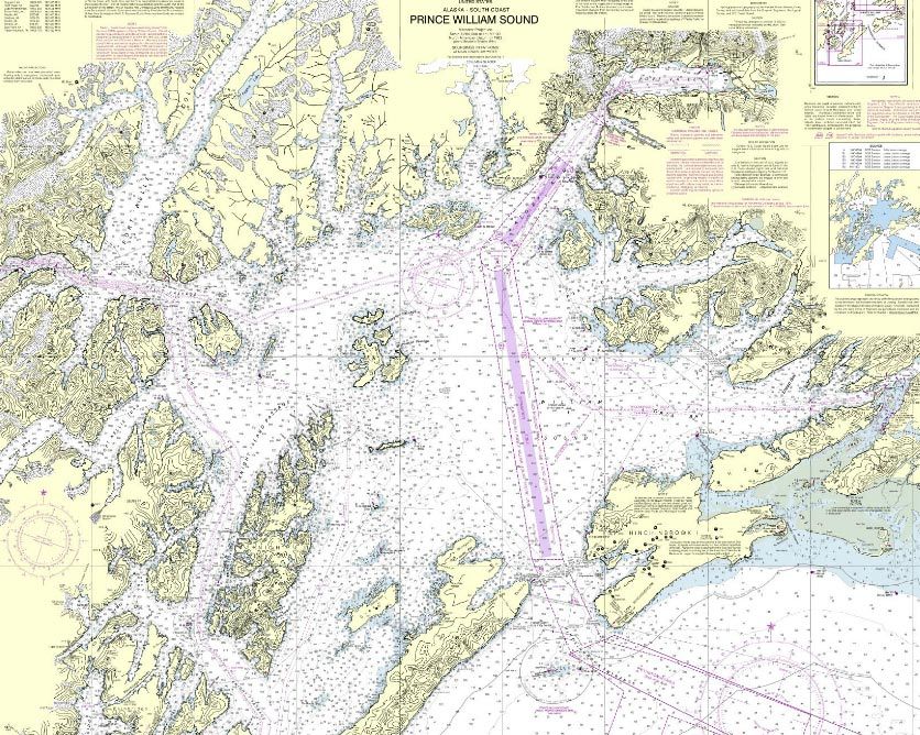
Reference Chartlets
Prince William Sound VTS Area
Prince William Sound VTS Area (VTSA)
The Prince William Sound VTSA encompasses the same area as the Regulated Navigation Area. The
VTS Area and the Regulated Navigation Area are defined as:
“The navigable waters of the U.S., north of a line drawn from Cape Hinchinbrook Light to Schooner
Rock light, comprising that portion of Prince William Sound between 146°30'W and 147°20'W and
includes Valdez Arm, Valdez Narrows, and Port Valdez.” [33 CFR 161.2 and 165.1704]
19VTS Prince William Sound User’s Manual – April 2014 Edition
Valdez Narrows VTS Special Area
Valdez Narrows VTS Special Area
Special operating requirements apply in a VTS Special Area as outlined in 33 CFR 161.13 and 161.60.
The Valdez Narrows VTS Special Area is described as the waters northeast of a line bearing 307° true
from Tongue Point at 61°02'06''N, 146°40'00''W and southwest of a line bearing 307° true from
Entrance Island Light at 61°05'06''N, 146°36'42''W. [33 CFR 161.60 and 165.1704]
20VTS Prince William Sound User’s Manual – April 2014 Edition
Valdez Arm VTS Special Area
Valdez Arm VTS Special Area
Special operating requirements apply in a VTS Special Area as outlined in 33 CFR 161.13 and 161.60.
The Valdez Arm VTS Special Area consists of those waters of the Valdez Arm Traffic Separation
Scheme, consists of an area south of a line bearing 307º true from Tongue Point, 61º02.10’N,
146º40.00’W, to the Northern Boundary of the Bligh Reef Precautionary Area, as well as those waters
northeast of a line drawn from shoreline to shoreline through the points 60º58.04’N, 146º46.52’W and
60º58.93’N, 146º48.86’W and southeast of a line bearing 307º true from Tongue Point at 61º02.10’N,
146º40.00’W. [33 CFR 161.60 and 165.1704]
21VTS Prince William Sound User’s Manual – April 2014 Edition
VTS Prince William Sound Reporting Points
5
4B
4A
3B 3A
2B
2A
1B
1A
VTS Prince William Sound Reporting Points
1A - Cape Hinchinbrook (Northbound only) 60°16'18''N, 146°45'30''W.
1B - Schooner Rock (Southbound only) 60°18'42''N, 146°51'36''W.
2A - Naked Island (Northbound only) 60°40'00''N, 146°56'00''W.
2B - Naked Island (Southbound only) 60°40'00''N, 147°00'00''W.
3A - Bligh Reef (Northbound only) 60°50'36''N, 146°57'30''W.
3B - Bligh Reef (Southbound only) 60°51'00''N, 147°01'24''W.
4A - Rocky Point (Northbound only) 60°57'48''N, 146°47'30''W.
4B - Rocky Point (Southbound only) 60°57'48''N, 146°50'00''W.
5 - Entrance Island 60°05'24''N, 146°37'30''W.
*NOTE: For additional information on reporting points, see 33 CFR 161.60 and 165.1704.
22VTS Prince William Sound User’s Manual – April 2014 Edition
Points of Contact:
VTS Prince William Sound and MSU Valdez (Captain of the Port)
Address: Commanding Officer
U.S. Coast Guard MSU Valdez
P.O. Box 486
105 Clifton Drive
Valdez, AK 99686
Vessel Traffic Center: (907) 835-7205 (24 hours)
Director, Vessel Traffic Service: (907) 835-7209
Fax: (907) 835-7286
Radio: VHF-FM Channel 13
Website: http:// homeport.uscg.mil/valdez
MSU Valdez Command Duty Officer (24 hour contact for non-VTS matters): (907) 831-0236
Coast Guard Sector Anchorage (Search & Rescue)
Address: Commander
U.S. Coast Guard Sector Anchorage
G-Wing Bldg 49000 Army Guard Rd.
JBER, AK 99505
Sector Anchorage Command Center: (907) 428-4100 (24 hours)
Fax: (907) 428-4114
Radio: VHF-FM Channel 16
Seventeenth Coast Guard District
Address: Commander (dpw)
Seventeenth Coast Guard District
P.O. Box 25517
Juneau, AK 99802-5517
Coast Guard Regional Examination Center
Telephone: (907) 271-6730
National Response Center
Telephone: 1-800-424-8802 (24 hours)
Electronic Code of Federal Regulations
U.S. Government Printing Office: (GPO) website: http://www.ecfr.gov/
23VTS Prince William Sound User’s Manual – April 2014 Edition
Federal Regulations
• 33 CFR Part 26: Vessel Bridge to Bridge Radiotelephone Regulations
• 33 CFR Part 161: Vessel Traffic Management
• 33 CFR Part 165: Regulated Navigation Areas and Limited Access Areas
• IMO Rule 10
• IMO Standard Ship Reporting System
24VTS Prince William Sound User’s Manual – April 2014 Edition
33 CFR Part 26: Vessel Bridge to Bridge Radiotelephone Regulations
26.01 Purpose.
(a) The purpose of this part is to implement the provisions of the Vessel Bridge-to-Bridge Radiotelephone
Act. This part:
(1) Requires the use of the vessel bridge-to-bridge radiotelephone;
(2) Provides the Coast Guard's interpretation of the meaning of important terms in the Act;
(3) Prescribes the procedures for applying for an exemption from the Act and the regulations issued under
the Act and a listing of exemptions.
(b) Nothing in this part relieves any person from the obligation of complying with the rules of the road and
the applicable pilot rules.
§26.02 Definitions.
For the purpose of this part and interpreting the Act:
Act means the “Vessel Bridge-to-Bridge Radiotelephone Act”, 33 U.S.C. sections 1201-1208;
Length is measured from end to end over the deck excluding sheer;
Power-driven vessel means any vessel propelled by machinery; and
Secretary means the Secretary of the Department in which the Coast Guard is operating;
Territorial sea means all waters as defined in §2.22(a)(1) of this chapter.
Towing vessel means any commercial vessel engaged in towing another vessel astern, alongside, or by
pushing ahead.
Vessel Traffic Services (VTS) means a service implemented under Part 161 of this chapter by the United
States Coast Guard designed to improve the safety and efficiency of vessel traffic and to protect the environment.
The VTS has the capability to interact with marine traffic and respond to traffic situations developing in the VTS
Area.
Vessel Traffic Service Area or VTS Area means the geographical area encompassing a specific VTS area of
service as described in Part 161 of this chapter. This area of service may be subdivided into sectors for the
purpose of allocating responsibility to individual Vessel Traffic Centers or to identify different operating
requirements.
NOTE: Although regulatory jurisdiction is limited to the navigable waters of the United States, certain vessels will be
encouraged or may be required, as a condition of port entry, to report beyond this area to facilitate traffic management within
the VTS Area.
(Rule 1, International Regulations for Preventing Collisions at Sea, 1972 (as rectified); EO 11964 (14 U.S.C. 2); 49 CFR
1.46(b))
[CGD 71-114R, 37 FR 12720, June 28, 1972, as amended by CGD 77-118a, 42 FR 35784, July 11, 1977; CGD 90-020, 59 FR
36322, July 15, 1994; USCG-2001-9044, 68 FR 42601, July 18, 2003]
25VTS Prince William Sound User’s Manual – April 2014 Edition
§26.03 Radiotelephone required.
(a) Unless an exemption is granted under §26.09 and except as provided in paragraph (a)(4) of this section,
this part applies to:
(1) Every power-driven vessel of 20 meters or over in length while navigating;
(2) Every vessel of 100 gross tons and upward carrying one or more passengers for hire while navigating;
(3) Every towing vessel of 26 feet or over in length while navigating; and
(4) Every dredge and floating plant engaged in or near a channel or fairway in operations likely to restrict or
affect navigation of other vessels except for an unmanned or intermittently manned floating plant under the control
of a dredge.
(b) Every vessel, dredge, or floating plant described in paragraph (a) of this section must have a
radiotelephone on board capable of operation from its navigational bridge, or in the case of a dredge, from its
main control station, and capable of transmitting and receiving on the frequency or frequencies within the 156-162
Mega-Hertz band using the classes of emissions designated by the Federal Communications Commission for the
exchange of navigational information.
(c) The radiotelephone required by paragraph (b) of this section must be carried on board the described
vessels, dredges, and floating plants upon the navigable waters of the United States.
(d) The radiotelephone required by paragraph (b) of this section must be capable of transmitting and
receiving on VHF FM channel 22A (157.1 MHz).
(e) While transiting any of the following waters, each vessel described in paragraph (a) of this section also
must have on board a radiotelephone capable of transmitting and receiving on VHF FM channel 67 (156.375
MHz):
(1) The lower Mississippi River from the territorial sea boundary, and within either the Southwest Pass safety
fairway or the South Pass safety fairway specified in 33 CFR 166.200, to mile 242.4 AHP (Above Head of
Passes) near Baton Rouge;
(2) The Mississippi River-Gulf Outlet from the territorial sea boundary, and within the Mississippi River-Gulf
outlet Safety Fairway specified in 33 CFR 166.200, to that channel's junction with the Inner Harbor Navigation
Canal; and
(3) The full length of the Inner Harbor Navigation Canal from its junction with the Mississippi River to that
canal's entry to Lake Pontchartrain at the New Seabrook vehicular bridge.
(f) In addition to the radiotelephone required by paragraph (b) of this section, each vessel described in
paragraph (a) of this section while transiting any waters within a Vessel Traffic Service Area, must have on board
a radiotelephone capable of transmitting and receiving on the VTS designated frequency in Table 161.12(c) (VTS
and VMRS Centers, Call Signs/MMSI, Designated Frequencies, and Monitoring Areas).
NOTE: A single VHF-FM radio capable of scanning or sequential monitoring (often referred to as “dual watch” capability)
will not meet the requirements for two radios.
[CGD 91-046, 57 FR 14485, Apr. 21, 1992; 57 FR 21740, May 22, 1992, as amended by CGD 90-020, 59 FR 36322, July 15,
1994; CGD 95-033, 60 FR 28328, May 31, 1995; CGD 92-052, 61 FR 45325, Aug. 29, 1996; CGD-1999-6141, 64 FR 69635,
Dec. 14, 1999; USCG-2003-14757, 68 FR 39364, July 1, 2003]
26VTS Prince William Sound User’s Manual – April 2014 Edition
§26.04 Use of the designated frequency.
(a) No person may use the frequency designated by the Federal Communications Commission under
section 8 of the Act, 33 U.S.C. 1207(a), to transmit any information other than information necessary for the safe
navigation of vessels or necessary tests.
(b) Each person who is required to maintain a listening watch under section 5 of the Act shall, when
necessary, transmit and confirm, on the designated frequency, the intentions of his vessel and any other
information necessary for the safe navigation of vessels.
(c) Nothing in these regulations may be construed as prohibiting the use of the designated frequency to
communicate with shore stations to obtain or furnish information necessary for the safe navigation of vessels.
(d) On the navigable waters of the United States, channel 13 (156.65 MHz) is the designated frequency
required to be monitored in accordance with §26.05(a) except that in the area prescribed in §26.03(e), channel 67
(156.375 MHz) is the designated frequency.
(e) On those navigable waters of the United States within a VTS area, the designated VTS frequency is an
additional designated frequency required to be monitored in accordance with §26.05.
(85 Stat. 164; 33 U.S.C. 1201-1208; 49 CFR 1.46(n)(2))
[CGD 71-114R, 37 FR 12720, June 28, 1982, as amended by CGD 83-036, 48 FR 30107, June 30, 1983; CGD 91-046, 57 FR
14486, Apr. 21, 1992; 57 FR 21741, May 22, 1992; CGD 90-020, 59 FR 36323, July 15, 1994; CGD 95-033, 60 FR 28329,
May 31, 1995]
§26.05 Use of radiotelephone.
Section 5 of the Act states that the radiotelephone required by this Act is for the exclusive use of the master
or person in charge of the vessel, or the person designated by the master or person in charge to pilot or direct the
movement of the vessel, who shall maintain a listening watch on the designated frequency. Nothing herein shall
be interpreted as precluding the use of portable radiotelephone equipment to satisfy the requirements of this act.
[CGD 93-072, 59 FR 39963, Aug. 5, 1994]
§26.06 Maintenance of radiotelephone; failure of radiotelephone.
Section 6 of the Act states:
(a) Whenever radiotelephone capability is required by this Act, a vessel's radiotelephone equipment shall be maintained
in effective operating condition. If the radiotelephone equipment carried aboard a vessel ceases to operate, the master shall
exercise due diligence to restore it or cause it to be restored to effective operating condition at the earliest practicable time.
The failure of a vessel's radiotelephone equipment shall not, in itself, constitute a violation of this Act, nor shall it obligate the
master of any vessel to moor or anchor his vessel; however, the loss of radiotelephone capability shall be given consideration
in the navigation of the vessel.
§26.07 Communications.
No person may use the services of, and no person may serve as, a person required to maintain a listening
watch under section 5 of the Act, 33 U.S.C. 1204, unless the person can communicate in the English language.
[CGD 90-020, 59 FR 36323, July 15, 1994, as amended by CGD 95-033, 60 FR 28329, May 31, 1995]
27You can also read