View across Castle Street looking north
←
→
Page content transcription
If your browser does not render page correctly, please read the page content below
Perceived additional height resulting from
               the variation from the coastal height policy
               provision (shown in bright red)
                                                                     Extent of variation from the R-Codes R80 deemed-to-
                                                                     comply provisions (shown in pale red )

                                                                                                            Coastal height policy envelope (yellow dashed line)

                                                                              Profile of the proposed
                                                                              development

                                                              Extent of variation from the coastal height
                                                              policy (shown in pale yellow)

Frame of reference

View across Castle Street looking north
Extent of the frame reference occupied by the extent of the proposed building above the coastal height policy envelope: 1.5%
Extent of the human field of vision occupied by the extent of the proposed building above the coastal height policy envelope: 0.75%

Conclusion: The visual impact of the proposed building above the coastal height policy envelope from this viewpoint is negligible.

99 Flora Terrace and 24 Lawley Street, North Beach                                                                                    mackayurbandesign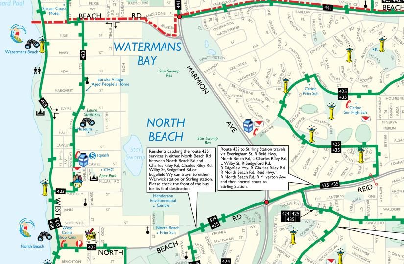
Coastal height policy envelope (yellow dashed line)

                                                                      Extent of variation from the R-Codes R80 deemed-to-
                                                                      comply provision (shown in pale red )

                                                                                         Development recently
                                                                                         approved by Council

                     Profile of the proposed development

                                                                      Extent of variation from the coastal height
                                                                      policy (shown in pale yellow)

Frame of reference

View from Flora Terrace /Lawley Street intersection looking southeast
Extent of the frame reference occupied by the extent of the proposed building above the coastal height policy envelope: 0.3%
Extent of the human field of vision occupied by the extent of the proposed building above the coastal height policy envelope: 0.2%

Conclusion: The visual impact of the proposed building above the coastal height policy envelope from this viewpoint is negligible.

99 Flora Terrace and 24 Lawley Street, North Beach                                                                          mackayurbandesign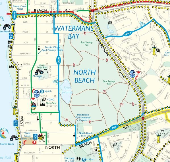
Extent of variation from the R-Codes R80
                                                                     deemed-to-comply provisions (shown in pale
                                                                     red )

                                                                                         Coastal height policy envelope (yellow dashed line)

                                                                                              Development recently approved by Council

                                                            Profile of the proposed development

                                                       Extent of variation from the coastal height
                                                       policy (shown in pale yellow)

Frame of reference

View across Castle Street looking northwest

Extent of the frame reference occupied by the extent of the proposed building above the coastal height policy envelope: 2.1%
Extent of the human field of vision occupied by the extent of the proposed building above the coastal height policy envelope: 1.05%

Conclusion: No visual impact of the proposed building beyond the coastal height policy envelope from this viewpoint.

99 Flora Terrace and 24 Lawley Street, North Beach                                                                           mackayurbandesign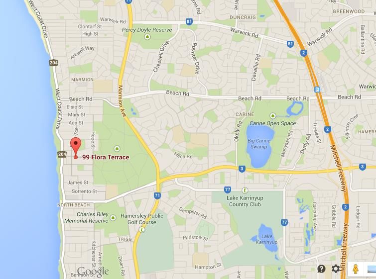
Summary and conclusion
In all of the viewpoints selected, the visual impact of the proposed building where it would be visible beyond the building envelope described
by the coastal height policy ranges from zero to negligible. As a percentage of what can be seen by the human eye from each viewpoint, the
additional building mass visible beyond the coastal height policy envelope varies between 0% and 1.05% of the field of view. By way of
comparison, a percentage of 10% would be described as marginal and a percentage of 20% or more would be a cause for concern.

As such, it is reasonable to conclude that the visual impact of the proposed building where it would be visible beyond the building envelope
described by the coastal height policy is so small that it has no impact on visual amenity from the surrounding public domain. Considering
also that the building mass above the the coastal height policy envelope gives no rise to other quantifiable impacts such as unacceptable
overshadowing, wind effects or overlooking, there is no reason why the variation from Clause 6.3 Coastal Height Limit - Non Residential
Zones Special Control Area (costal height policy) could be considered as inappropriate.

99 Flora Terrace and 24 Lawley Street, North Beach                                                                   mackayurbandesign
CONSULTING CIVIL & TRAFFIC ENGINEERS, RISK MANAGERS

  Project:    Transport Impact and Parking Assessment - V3
              99 Flora Terrace, North Beach
              Proposed Mixed-Use Development

   Client:    NS Property

   Author:    Heidi Lansdell

Signature:

     Date:   9th February 2015

  1 ST. FLOOR, 908 ALBANY HIGHWAY, EAST VICTORIA PARK WA 6101.
  PHONE                              +61 8 9355 1300
  FACSIMILE                          +61 8 9355 1922
  EMAIL                              admin@shawmac.com.au
Consulting Civil and Traffic Engineers, Risk Managers

Document Status.

   Ver. No.                 Author                 Reviewed by                      Date         Issued for         Signature            Date

        1               H. Lansdell                  T. Shaw                    09/09/14          FINAL                               11/09/14

        2               H. Lansdell                 P. Nguyen                   27/10/14           REV                                27/10/14
                                                                                                  FINAL

        3               H. Lansdell                 P. Nguyen                   09/02/15           REV                                10/02/15
                                                                                                  FINAL

SHAWMAC PTY LTD
ABN 51 828 614 001
PO BOX 937
SOUTH PERTH WA 6951
T: + 61 8 9355 1300
F: + 61 8 9355 1922
E: admin@shawmac.com.au
© Shawmac Pty. Ltd. 2013

C:\Toby\NS Property_99 Flora Terrace_1407018\NS Property_99 Flora Terrace_TIA_271014.docx

                                                                                       Page ii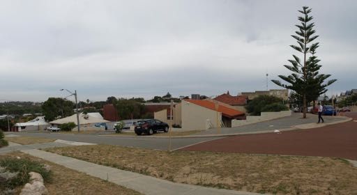
Consulting Civil and Traffic Engineers, Risk Managers

CONTENTS
1.      Introduction .................................................................................................................................. 1

 1.1       Background ............................................................................................................................................ 1

 1.2       Site Access Arrangements ..................................................................................................................... 2

 1.3       Car Parking Arrangements..................................................................................................................... 2

2.      Existing Situation.......................................................................................................................... 3

 2.1.      Existing Site Use and Parking Provision ................................................................................................ 3

 2.2.      Existing Surrounding Land Uses ............................................................................................................ 3

 2.3.      Existing Surrounding Road Network ...................................................................................................... 3
     2.3.1.        Road Hierarchy ............................................................................................................................. 3
     2.3.2.        Intersections .................................................................................................................................. 4

 2.4.      Existing Traffic Volumes......................................................................................................................... 4

 2.5.      Existing Pedestrian/Cyclist Networks ..................................................................................................... 5

 1.1       Existing Public Transport ....................................................................................................................... 6

 1.2       Crash History ......................................................................................................................................... 7

3.      Changes To Surrounding Transport Networks ............................................................................. 7

4.      Integration with Surrounding Area ................................................................................................ 7

5.      Analysis of Transport Networks.................................................................................................... 8

 5.1.      Assessment Years ................................................................................................................................. 8

 5.2.      Time Periods for Assessment ................................................................................................................ 8

6.      Traffic Generation and Distribution............................................................................................... 8

 6.1.      Traffic Generation .................................................................................................................................. 8

 6.2.      Traffic Distribution .................................................................................................................................. 8

 6.3.      Crash History ......................................................................................................................................... 9

 6.4.      Rubbish Collection and Servicing .......................................................................................................... 9

7.      Review of On-Site Circulation, Service/Delivery Arrangements and Sightlines ............................ 9

8.      Car Parking Assessment and Management ............................................................................... 10

                                                                          Page iii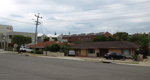
Consulting Civil and Traffic Engineers, Risk Managers

9.    Pedestrian and Cyclist Demand and Facility Assessment ......................................................... 14

10.   Public Transport Accessibility .................................................................................................... 14

11.   Revised Conclusions.................................................................................................................. 14

12.   Appendix A – REVISED Site Plan .............................................................................................. 16

                                                                Page iv
Consulting Civil and Traffic Engineers, Risk Managers
1. INTRODUCTION
1.1 Background
Shawmac has prepared an updated Transport Impact and Parking Assessment report, following the State
Administrative Tribunal mediation on 4th February 2015, which is reflective of discussions with the WAPC and the
City of Stirling and in the context of revised development plans for 99 Flora Terrace, North Beach, in the City of
Stirling. This updated report has assessed the potential traffic impacts and car parking and access issues
associated with the proposed mixed-use development to be located at 99 Flora Terrace, North Beach, in the City
of Stirling. This revised assessment has been prepared in accordance with the WAPC Transport Impact
Assessment Guidelines: Vol 4 – Individual Developments and the City of Stirling’s Local Planning Scheme No. 3
– Policy Manual: Section 6 – Parking Access Policy 6.7 and addresses the comments issued by the City of Stirling.
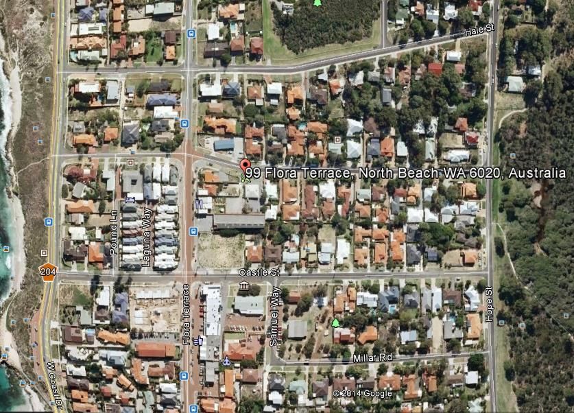
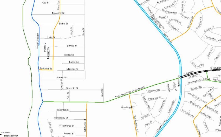
The site is located on a residential street in the suburb of North Beach in the City of Stirling and is shown in Figure
1.
Figure 1 – Local Context
The general metropolitan context of the proposal is shown in Figure 2.
Page 1Consulting Civil and Traffic Engineers, Risk Managers
Figure 2 – Metropolitan Context
The revised proposal consists of 28 multiple dwellings, 204 m2 of office uses and a 36-seat café/restaurant.
Proposed access to the on-site car parking area will be afforded via the south side of Lawley Street, east of Flora
Terrace. A copy of the revised site plan is attached in in Appendix A.
A site visit was conducted on 1st September 2014 to identify any potential traffic-related issues associated with
the proposal. The City of Stirling was also contacted in order to obtain the most recent traffic volumes for the local
road network and additional traffic and road crash data has been sourced from MRWA. Subsequent to this visit,
detailed car parking surveys were undertaken on Flora Terrace on Thursday 5th February, Friday 6th February and
Saturday 7th February 2015 to ascertain the residual level of available of public car parking on-street adjacent to
the development.
1.2 Site Access Arrangements
Primary vehicular access to the site will be accommodated via a full movements crossover to the south side of
Lawley Street, approximately 70m east of Flora Terrace leading to an undercroft car parking area.
1.3 Car Parking Arrangements
The proposed parking supply for the development consists of a single level of car parking at ground level
incorporating 53 car parking bays (42 residential bays including 14 bays in 7 car stackers and 11 commercial bays
including 1 ACROD bay). An additional bay is proposed within the verge on Lawley Street.
Page 2Consulting Civil and Traffic Engineers, Risk Managers
2. EXISTING SITUATION
2.1. Existing Site Use and Parking Provision
The property at 99 Flora Terrace currently has a gym/squash court facility comprising 1,500 m2 with 12 car parking
bays on the site.
2.2. Existing Surrounding Land Uses
The site is currently bounded by residential uses to the north, east and west with a mix of residential and small
commercial tenancies to the south along Flora Terrace.
2.3. Existing Surrounding Road Network
2.3.1. Road Hierarchy
West Coast Drive
West Coast Drive runs in a broad north-south direction approximately 225m west of the site. It has been
constructed as a single divided carriageway in the vicinity of the subject lands. Under the Main Roads Western
Australia (MRWA) Functional Road Hierarchy, West Coast Drive has been classified as a District Distributor A
road which is defined as a road which “…connects to Primary and other Distributor roads and facilitates high
capacity traffic movements between industrial, commercial and residential areas.” In the vicinity of the site, West
Coast Drive operates under a posted speed limit of 50kph and is owned, operated and maintained by the City of
Stirling.
Flora Terrace
Flora Terrace runs in a north-south direction between Malcolm Street and Beach Road along the western
boundary of the site. It has been constructed as a single undivided carriageway across the frontage of the site. It
currently operates under a posted speed limit of 50 km/h. Under the Main Roads Western Australia (MRWA) Road
Hierarchy, Flora Terrace has been classified as a Local Distributor road which is defined as a road which “…plays
a minor network role and connects to Distributor and Access roads and facilitates movement of road traffic within
local areas.” Under existing conditions, there is indented on-street parallel parking on both sides of Flora Terrace
between Castle Street and Lawley Street. It is owned, operated and maintained by the City of Stirling.
Lawley Street
Lawley Street runs along the northern boundary of the site in an east-west direction between West Coast Drive
and Hope Street. It has been constructed as a single undivided carriageway and currently under an unposted
speed limit of 50kph. Under the Main Roads Western Australia (MRWA) Road Hierarchy, Lawley Street has been
classified as an Access Road which is defined as a road which “…provides mainly for local access to abutting
Page 3Consulting Civil and Traffic Engineers, Risk Managers
properties and connects to Local Distributors and higher order roads”.
Figure 3 shows the existing road classification under the MRWA Road Information Mapping System for roads in
the vicinity of the site.
SUBJECT SITE
Figure 3 - Main Roads WA Road Hierarchy- Local Road Network
2.3.2. Intersections
The intersection of West Coast Drive/Lawley Street is a T-intersection with Give Way Control in place on the
Lawley Street approach to the intersection.
The intersection of Flora Terrace and Lawley Street is a 4-legged unsignalised intersection with Stop Control in
place on the Lawley Street approaches to the intersection. A pedestrian crossing is in place on northbound
approach (southern leg) of Flora Terrace to the intersection.
2.4. Existing Traffic Volumes
Traffic data sourced from MRWA indicates that the average existing weekday daily traffic volumes are shown in
Table 1.
Page 4Consulting Civil and Traffic Engineers, Risk Managers
Table 1 - Existing Weekday Daily Traffic Volumes for Primary Boundary Road Network
Road Existing Weekday Daily Traffic Volume (vpd)
West Coast Drive (north of North Beach Road) 17,000 vpd (April 2013)
Flora Terrace (North of Castle Street) 1,450 vpd (April 2014)
Lawley Street (east of Flora Terrace) Not available (assumed to have a practical capacity
of 1,500 to 2,000 vpd)
2.5. Existing Pedestrian/Cyclist Networks
Existing pedestrian infrastructure in the vicinity of the site includes:
A shared path on the western side of West Coast Drive;
A Principal Shared Path on Hope Street to the east of the site;
Footpaths in place on the east side of West Coast Drive, south side of Lawley Street and on both sides
of Flora Terrace along the western boundary of the site; and
Flora Terrace designated as a Bicycle Friendly Street.
An extract from the Department of Transport (DoT) TravelSmart Walk and Cycle Map – City of Stirling (West) is
shown in Figure 4 and illustrates the extent of the existing pedestrian/cyclist network within the vicinity of the site.
Page 5Consulting Civil and Traffic Engineers, Risk Managers
SUBJECT SITE
Figure 4 – Existing Cycling and Pedestrian Infrastructure
1.1 Existing Public Transport
The subject site has excellent access to the public transport network and is located within short walking distance
of an existing line haul bus route Route 423 (Stirling Station-Warwick Station via Karrinyup Bus Station and Hillarys
Boat Harbour) on Flora Terrace with stops on both sides of the road to the north and south of Lawley Street,
respectively. This existing service (as of 21 September 2014) will provide 15-minute service during the weekday
a.m. and p.m. peak periods, respectively, and half hourly service during the midday and evening off-peak and
weekend periods.
Figure 5 shows the existing public transport services in the area.
Page 6Consulting Civil and Traffic Engineers, Risk Managers
SUBJECT SITE
Figure 5 - Travel Smart Map: Public Transport Infrastructure in Vicinity of Site
1.2 Crash History
A review of the crash history indicates a total of 2 crashes on Lawley Street during the 5-year reporting period
2009-2013, inclusive, with none of these crashes involving a vehicle entering and/or exiting a driveway or at the
intersection with both crashes identified as rear end crashes. No crashes were recorded at the intersection of
Flora Terrace/Lawley Street during this reporting period.
3. CHANGES TO SURROUNDING TRANSPORT NETWORKS
There are no major planned changes to the surrounding transport network in the vicinity of the subject site.
4. INTEGRATION WITH SURROUNDING AREA
The major generators in the area include the North Beach foreshore area to the west of the site, existing small
tenancy commercial uses along Flora Terrace to the south of the site and the existing residential catchment to the
north, south and east of the site. The site is located within a Business Zone according to the City of Stirling’s Local
Planning Scheme No. 3.
The proposed development on the site is expected to integrate well with the surrounding area and the existing
road network. The proposed land use generally conforms to the existing and proposed land uses in the
surrounding area.
Page 7Consulting Civil and Traffic Engineers, Risk Managers
5. ANALYSIS OF TRANSPORT NETWORKS
5.1. Assessment Years
The assessment is based on the full development of the site.
5.2. Time Periods for Assessment
The proposed development will consist of 29 multiple dwelling residential units, 60 m2 of commercial uses and a
36-seat restaurant. Based upon a combination of existing traffic data for the surrounding road network sourced
from MRWA and on the proposed land uses, the period of greatest demand on the road network coincides with
typical weekday morning and afternoon peak periods. Therefore the trip generation and traffic analysis will be
under taken for both the peak A.M. and peak P.M. hours. The road network performance has been assessed for
each period under both the existing (pre-development) and future (post-development) scenario to determine the
transport impact of the proposed development on the surrounding road network.
The road network peak periods were determined to be 8:00 to 9:00 a.m. in the morning and 5:00 to 6:00 p.m. in
the afternoon.
6. TRAFFIC GENERATION AND DISTRIBUTION
6.1. Traffic Generation
Trip generation rates were applied to determine the revised traffic generation by the proposed uses on the site.
The rates were derived from the Institute of Transportation Engineers (ITE) Trip Generation Manual, 7th Edition.
The category chosen for assessment purposes was Residential Condominium/Townhouse (Category 230),
General Office (Category 710) and Quality Restaurant (Category 931) which reflected trip generation rates
consistent with developments in this type of area and would reflect the ‘worst case’ scenario associated demands
on the road network.
The results of the trip generation indicates that the site will generate a total of 361 vehicular trips on a typical
weekday (180 trips inbound/181 trips outbound) with approximately 32 vehicular trips (14 in/18 out) during the
a.m. peak hour and 33 vehicular trips (21 in/12 out) during the p.m. peak hour.
6.2. Traffic Distribution
Based upon the spatial distribution of land uses in the area, the location of the major traffic attractors/generators
and the proposed layout of the car parking and access to the site as well as the spatial layout of the local road
network, the following assumptions for the distribution of the site-generated traffic have been made:
20% of site-generated traffic originates from and is destined to the north and north-east via West Coast
Drive and Lawley Street;
50% of site-generated traffic originates from and is destined to the south and south-east via West Coast
Drive and Lawley Street;
Page 8Consulting Civil and Traffic Engineers, Risk Managers
10% of site-generated traffic originates from and is destined to the south via Flora Terrace;
10% of the balance of site-generated traffic is originating from and is destined to the north via Flora
Terrace; and
10% of site-generated traffic is originating from and is destined to the east via Lawley Street.
The anticipated site-generated traffic was then assigned onto the boundary road system based upon the
assumptions above and the resultant increases in weekday daily and peak hour traffic on the boundary roads
associated with the proposed development are as follows:
West Coast Highway:
o Weekday Daily: +232 vehicular trips
o Weekday A.M. Peak Hour: +22 vehicular trips
o Weekday P.M. Peak Hour: +23 vehicular trips
Flora Terrace:
o Weekday Daily: +66 vehicular trips
o Weekday A.M. Peak Hour: +6 vehicular trips
o Weekday P.M. Peak Hour: +7 vehicular trips
Lawley Street:
o Weekday Daily: +331 vehicular trips
o Weekday A.M. Peak Hour: +32 vehicular trips
o Weekday P.M. Peak Hour: +33 vehicular trips
The anticipated increases in vehicular traffic on the boundary road network associated with the proposed
development on the site can be comfortably accommodated within the existing practical capacity of the road
network and is not expected to have any significant impact on the existing traffic operations of these roads. No
additional assessment at the intersection of Flora Terrace and Lawley Street is warranted due to the existing low
traffic volumes on these roads.
6.3. Crash History
The very low number of crashes along the respective frontages of the site would indicate that that there would be
minimal risk associated with entering and exiting the site crossover to Lawley Street and the existing risk profile
would not be impacted along this section of road.
6.4. Rubbish Collection and Servicing
Rubbish collection would be undertaken via kerbside collection via the north side of Lawley Street and would be
negotiated in consultation with the City of Stirling.
7. REVIEW OF ON-SITE CIRCULATION, SERVICE/DELIVERY ARRANGEMENTS
AND SIGHTLINES
A brief review was undertaken with regard to the proposed layout of the basement car park and it can be concluded
that the layout of the car parking bays and circulation is safe and appropriate and in line with industry guidelines
Page 9Consulting Civil and Traffic Engineers, Risk Managers
and standards such as Austroads and Australian Standards.
The proposed layout of the car parking within the undercroft area is appropriate and consistent with Australian
Standard AS 2890.1: Off-Street Parking and relevant traffic engineering standards.
All vehicles will be able to enter and exit the site in forward gear.
8. CAR PARKING ASSESSMENT AND MANAGEMENT
The proposed on-site car parking supply consists of 53 bays to be provided in the basement undercroft level
consisting of 42 residential tenant bays (including 14 bays in 7 car stackers) and 11 commercial bays (including
1 ACROD bay).
The required car parking supply for the site is as follows according to the City’s Local Planning Scheme No. 3 and
the City’s Parking and Access Policy 6.7.
28 multiple dwellings – as per R-Codes: 29 bays (Location A within 250m of high-frequency bus route)
+ 7) – 34 bays + 7 visitor bays = 41 bays
205 m2 of commercial uses = 7 bays (1/30 m2)
36-seat restaurant (105 m2)- 15 bays
TOTAL REQUIREMENT: 63 bays
The application of the concession of 20% for in the context of the policy, if only applied to the non-residential
component, whereby the site is located within a Business Zone and that end-of-trip facilities and bicycle storage
in excess of Council requirements would result in a net reduction of 4 bays to a total theoretical requirement of 59
car parking bays. As noted in the original October 2014 Transport and Parking Assessment, the requirement for
residential visitor bays (7 bays) can be offset against the office car parking on the site as the peak periods do not
coincide with the net requirement through the application of reciprocity between visitor car parking and commercial
parking resulting in 52 bays on the site. This approach is consistent with the tenets set out in the City’s Policy 6.7
Section 5.2.2: Reciprocal Parking.
Detailed car parking surveys undertaken on Thursday 5th February, Friday 6th February and Saturday 7th February 2015 in
2015 in relation to identifying any residual capacity in the existing on-street car parking supply on Flora Terrace has yielded the
has yielded the following results as noted in
Page 10Consulting Civil and Traffic Engineers, Risk Managers
Parking Demand/Surplus (bays) - Thurs 5th February 2015
Flora Tce Castle Street Total:
Demand Surplus Demand Surplus Demand Surplus
Time
1130 a.m. 4 15 3 4 7 19
1200 p.m. 3 16 2 5 5 21
1230 p.m. 5 14 1 6 6 20
100 p.m. 2 17 1 6 3 23
530 p.m. 2 17 0 7 2 24
600 p.m. 4 15 0 7 4 22
630 p.m. 3 16 2 5 5 21
700 p.m. 1 18 2 5 3 23
730 p.m. 2 17 2 5 4 22
Parking Demand/Surplus (bays) - Fri 6th February 2015
Flora Tce Castle Street Total:
Demand Surplus Demand Surplus Demand Surplus
Time
1130 a.m. 2 17 1 6 3 23
1200 p.m. 6 13 0 7 6 20
1230 p.m. 3 16 1 6 4 22
100 p.m. 4 15 2 5 6 20
530 p.m. 0 19 0 7 0 26
600 p.m. 1 18 0 7 1 25
630 p.m. 0 19 1 6 1 25
700 p.m. 0 19 0 7 0 26
730 p.m. 1 18 0 7 1 25
Parking Demand/Surplus (bays) - Sat 7th February 2015
Flora Tce Castle Street Total:
Demand Surplus Demand Surplus Demand Surplus
Time
900 a.m 2 17 1 6 3 23
930 .m. 1 18 1 6 2 24
1000 a.m. 1 18 0 7 1 25
1030 a.m. 1 18 3 4 4 22
1100 a.m. 2 17 4 3 6 20
1130 a.m. 3 16 2 5 5 21
1200 p.m. 2 17 1 6 3 23
1230 p.m. 4 15 0 7 4 22
100 p.m. 2 17 1 6 3 23
Table 2.
Page 11Consulting Civil and Traffic Engineers, Risk Managers
Parking Demand/Surplus (bays) - Thurs 5th February 2015
Flora Tce Castle Street Total:
Demand Surplus Demand Surplus Demand Surplus
Time
1130 a.m. 4 15 3 4 7 19
1200 p.m. 3 16 2 5 5 21
1230 p.m. 5 14 1 6 6 20
100 p.m. 2 17 1 6 3 23
530 p.m. 2 17 0 7 2 24
600 p.m. 4 15 0 7 4 22
630 p.m. 3 16 2 5 5 21
700 p.m. 1 18 2 5 3 23
730 p.m. 2 17 2 5 4 22
Parking Demand/Surplus (bays) - Fri 6th February 2015
Flora Tce Castle Street Total:
Demand Surplus Demand Surplus Demand Surplus
Time
1130 a.m. 2 17 1 6 3 23
1200 p.m. 6 13 0 7 6 20
1230 p.m. 3 16 1 6 4 22
100 p.m. 4 15 2 5 6 20
530 p.m. 0 19 0 7 0 26
600 p.m. 1 18 0 7 1 25
630 p.m. 0 19 1 6 1 25
700 p.m. 0 19 0 7 0 26
730 p.m. 1 18 0 7 1 25
Parking Demand/Surplus (bays) - Sat 7th February 2015
Flora Tce Castle Street Total:
Demand Surplus Demand Surplus Demand Surplus
Time
900 a.m 2 17 1 6 3 23
930 .m. 1 18 1 6 2 24
1000 a.m. 1 18 0 7 1 25
1030 a.m. 1 18 3 4 4 22
1100 a.m. 2 17 4 3 6 20
1130 a.m. 3 16 2 5 5 21
1200 p.m. 2 17 1 6 3 23
1230 p.m. 4 15 0 7 4 22
100 p.m. 2 17 1 6 3 23
Table 2 – Car Parking Survey Results: Flora Terrace and Castle Street
The results of the surveys indicate that under typical demand periods the latent available on-street public car
parking supply ranges between 19 and 26 bays, with the peak coincident demand period for office and restaurant
occurring over a Thursday and Friday lunchtime period where the maximum parking demand for on-street car
parking is 7 bays.
Page 12This is an unlicensed copy of Split Pdf
This page will be appended to every output
in unlicensed mode only.
For purchase information see our website
http://www.traction-
software.co.uk/servertools/splitpdf/
Thank you,
support@traction-software.co.ukYou can also read