University College Dublin School of Architecture, Planning and Evironmental Policy
←
→
Page content transcription
If your browser does not render page correctly, please read the page content below

University College Dublin School of Architecture, Planning and Evironmental Policy

 “Repurposing farm land, unused land and hedgerows to create an expandable network of
      rewilded land while opening up an education and exercise amenity for locals.”

                           Student Name: Cathal Travers

                             Student Number: 16323643

                          Course: Landscape Architecture

                             Module Code: LARC 40360

                           Submission Date: 14/05/2020
Contents

1. Introduction                 P1

2. Precedent                    P 2-3

3. Site Selection               P 4-8

4. Site Analysis                P 9-14

5. Further Analysis & Concept   P 15-19

6. Design                       P 20-27

7. Atmosphere                   P 28-33

8. Conclusion                   P 34

9. Bibliography                 P35
Introduction

Having grown an interest for rewilding projects over my time studying Landscape Arhitecture in UCD, I wanted to
encorporate it into my Thesis study seeing that positive results had been coming from Rewilding studies in the past.
Knepp Estate in England had seen positive affects after undergoing a rewilding process on their estate.

Over the couse of this study I have selected sites, analysed, concepted and designed. The philosphy is to tranform
some unused land and create and expandable network of rewilded areas on the scale of other rewilding projects
such as Knepp.

My project will see two large areas of land connected with a ribbon of hedgerows and a river.

While Rewilding the land stands as the main characteristic of this project, I will be including a walkway and an
education centre, a centre that educates on the benefits of rewilding and what can be seen on site in terms of
vegetation and animal species.

The following pages will give a clear outline of the intentions of the project, its detail and design.

                                                            1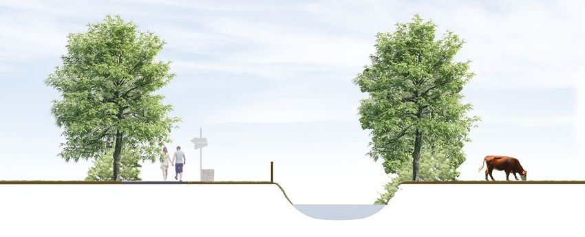
Precedent                                                 The vision of the Knepp Wildland Project is radically
                                                          different to conventional nature conservation in that it is
                                                          not driven by specific goals or target species. Instead, its
Knepp is a 3,500 acre estate just south of Horsham, West
                                                          driving principle is to establish a functioning ecosystem
Sussex. Since 2001, the land – once intensively farmed -
                                                          where nature is given as much freedom as possible. The
has been devoted to a pioneering rewilding project. Using
                                                          aim is to show how a ‘process-led’ approach can be a
grazing animals as the drivers of habitat creation, and
                                                          highly effective, low-cost method of ecological restoration
with the restoration of dynamic, natural water courses,
                                                          - suitable for failing or abandoned farmland - that can
the project has seen extraordinary increases in wildlife.
                                                          work to support established nature reserves and wildlife
Extremely rare species like turtle doves, nightingales,
                                                          sites, helping to provide the webbing that will one day
peregrine falcons and purple emperor butterflies are now
                                                          connect them together on a landscape scale.
breeding here; and populations of more common species
are rocketing.
                                                          Knepp Castle Estate comprises 3,500 acres of heavy
                                                          weald clay in West Sussex. Though farmed intensively
                                                          since WW2, the farm rarely made a profit. Rewilding has
                                                          turned this around. Knepp has attracted support from
                                                          Natural England through the Higher Level Stewardship
                                                          scheme. And its focus on rewilding has prompted
                                                          successful spin off enterprises. The farmland is now
                                                          profitable.

             Knepp Estate

                                                          2          Knepp Estate
             Knepp Estate
From the start, the project benefitted from the vision of
an influential advisory group. This included the Dutch
ecologist Frans Vera and CEO of Sussex Wildlife Trust,
Tony Whitbread.

Knepp Wildland’s ethos is to allow natural processes
rather than aiming for any particular goals or outcomes.
Free-roaming grazing animals - cattle, ponies, pigs and
deer - drive this process-led regeneration. They act
as proxies for herbivores that would have grazed the
land thousands of years ago. Their different grazing
preferences help create a mosaic of habitats from
grassland and scrub to open-grown trees and wood
pasture.

These animals need minimal intervention. At low cost,
they provide wild-range, slow-grown, pasture-fed organic
meat for which there is a growing market. The fact that
Knepp is still producing food – albeit extensively – has
been a useful ally.

In just over a decade Knepp has seen astonishing results
in biodiversity. It is now a breeding hotspot for purple
emperor butterflies, turtle doves and 2 per cent of the
UK’s population of nightingales. Initial opposition to the
project came from local people shocked at seeing the
changing appearance of the land. This is waning thanks
to these results. It still has problems to overcome - for
example, common ragwort.

                                                             3
Site Selection
1. Baltracey
I am currently living in Kildare, more precisely in an
area called Baltracey which is 10KM from our nearest
large town, Maynooth. Living down a cul-de-sac laneway
our house lies on the edge of my grandfather’s land.
My Grandparents, my two uncles and their families
along with my family, all live in a row of houses on the
land. The land itself amounts to 60 acres and has been
my grandfathers since 1951. Initially the land was in
grassland and was used for grazing for the dairy farm
that was once run. In the 1970’s a change was made
from dairy to tillage farming. Up until 2007 the land was
used for tillage crops, though towards the later stages,
less and less work was being done by our family. As                 South side hedgerow in Baltracey
machinery prices were becoming astronomical, keeping
up to date was just not viable for my grandfather. With         With no money being made another shift was made
that also came the rising costs of hiring a contractor to       in the spring of 2007. The agricultural advisors from
do the work for us.                                             teagasc had persuaded my uncles and granddad to
                                                                buy into a new and relatively unheard-of biomass crop
                                                                called miscanthus (elephant grass). This was grown up
                                                                until 2016, the crop never yielded and gains, it was a
                                                                complete failure. Then in the closing weeks of 2016, my
                                                                grandfather had to turn to his final option, he leased
                                                                the farm out on a 10-year lease. A large-scale beef and
                                                                tillage farmer from Straffan Co. Kildare is now intensively
                                                                farming barley and wheat off the land.

            Aerial view of Baltracey                        4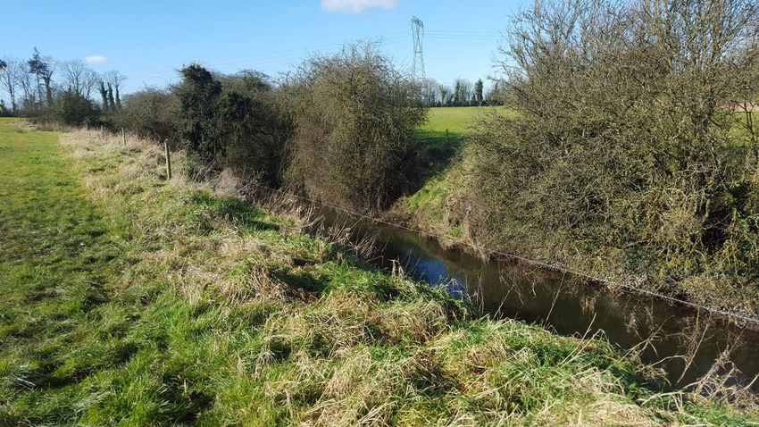
If we were to have “taken our hands of the steering              What characteristics does the land carry as we
wheel” what would happen? Charles Burrell and Isabella           speak?
Tree, the owners of Knepp estate simply removed
                                                                 • I know that there are currently two wet areas on the
and interior fences and gates along with any and all
drainage systems, pipes and troughs. For my family                 field that rely heavily on the drainage systems in place
to do the same in Baltracey, it wouldn’t be all that
                                                                   to allow water to flow away.
difficult. To finish a perimeter fence would be introduced
to contain any animals that would be allowed to roam             • Towards the south side of the field, we have spotted
free on the land. Charles and Isabella introduced Deer,            two fox’s on multiple occasions.
longhorn cattle, pigs and horses to the land, these are
representative of the animals that were present on the           • Other wildlife such as hare’s, pheasants and badgers
land before agriculture took over. Introducing a smaller           have been spotted on the land.
amount of those same animals onto a dramatically
smaller area of land. It raises a lot of questions.              • The soil is a heavy brown clay soil, that is difficult to
                                                                   work with, with machinery and requires piping to drain
• Will this formula have the same result for our much
                                                                   the surface.
  smaller amount of land?
                                                                 In my opinion there is currently characteristics present
• How long will it be before anything starts to change on        that should suggest that in the event that the farm is
                                                                 rewilded, there would be an injection of wildlife and
  the land?
                                                                 an almost immediate change in the land, most likely
• Would the land be capable of providing for these               the wet areas. 75% of the land perimeter is lined with
                                                                 dense vegetation, giving shelter to any animals that may
  animals year-round with no externally given feeds?             immediately be introduced (pigs, cattle, horses).

• Would money be made?

• Is the land area large enough for rewilding to take a

  positive effect?

• Are there any dangers?
                                                             5
Wet tracks showing high moisture on site     Evidence of miscanthus continuing to grow on the fields boundary

Pheasants roaming the land
                                           6 Spring time photo of the land
2. Maynooth                                                 The land I have marked above amounts to 44.93 acres.
                                                            45 acres of unused land is a huge amount, if rewilded
                                                            this could prove hugely beneficial to the local wildlife.
                                                            Maynooth tidy towns committee have worked on growing
                                                            the insect life population within the town by building
                                                            man made insect habitat huts within greenspaces.
                                                            They have also protested against the development of
                                                            car parks on Parson St. and on the Moyglare rd. to
                                                            maintain green space within the town. I think Maynooth
                                                            is a prime example of an ideal candidate to go forward
                                                            with rewilding with these 45 acres or more should it be
                                                            available.

                                                            Maynooth is just one example, with towns like Celbridge,
                                                            Lexlip, Clane, Kilcock, and Lucan surrounding Dublin, a
                                                            massive amount of land could be amassed and adapted
                                                            to be rewilded. Maynooth has a terrific tidy towns
 Maynooth town aerial view
                                                            committee that care hugely for the environment. They do
Sites such as these in Maynooth in my opinion should be
                                                            huge amounts of work within the town to see that it’s not
rewilded, in an effort to have a positive use for the now
                                                            only tidy but its environmentally friendly. Committees like
unused land and inject some green landscape into an
altogether grey landscape.                                  these along with local farmers could maintain and learn
                                                            from areas of land that have been rewilded.
The land shown with red and green markings above is
derelict and while developments have gone up on the         Benefits go on, local schools and organisations could use
land’s peripheries, the land marked in green owned by       these spaces for education in areas such as plant and
local farmer Roger Satchwell is unused due to its steep     wildlife identification and the environment. This rewilding
gradient. At the moment the land marked with green          within towns could spread interest to farmers in the local
is left to run wild, all it is missing is some animals to   areas and allow them to see any positive results that
manage it like we’ve seen in Knepp, a transition here to    may come from this project.
rewilding would not be difficult. The land marked in red
is land owned by Carton House and golf course. The land
marked in green is unused and has been denied planning
permission from construction of housing to take place     7
here.
3. The Lyreen                                                    The topographical level drops gradually from Baltracey to
                                                                 Maynooth. The river grows in depth and width as it gets
To achieve the desired scale of the project I would prefer       closer to Maynooth. The river crosses main roads on 5
to have the separate sites in Maynooth and Baltracey             ocasions.
to be connected to each other. Luckily the sites are
connected by the Lyreen river. Banking the river are             The Lyreen passes trough Maynooth University which
hedgerows that can in future be expanded in width,               open the opportunity to include a highly valued site on to
growing the area of the rewilded project.                        the projected walkway.

The overall distance of the river between sites is 10km
serving for an ideal greenway on which people could
walk, run or cycle and admire the vegetation and animal
species that would have spawned from the rewilding
process.

Lyreen river photo taken on Maynooth Univerity Farm land

                                                             8
Site Analysis
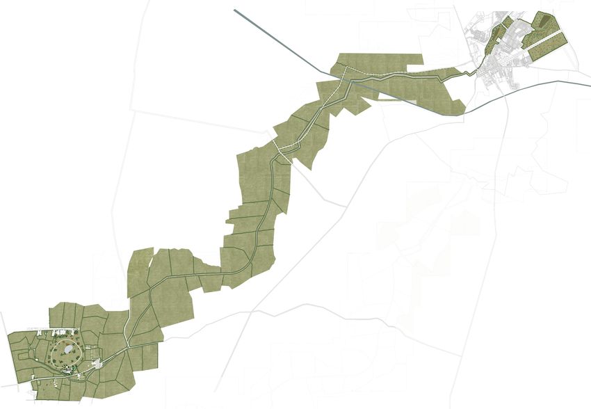
Overall scale
S5
S4
NORTH
Sun Rise Summer
Sun Set Summer
WEST EAST
Sun Rise Winter
Suns Rotation
Direction of
Sun Set Winter
4 pm 10 am
SOUTH
Cathal Travers
S3 16323643
Maynooth Town & Family
Land Site (Baltracey)
Scale NTS
Built up
areas
Canal
S1
Motorway
Field
Boundaries
S2 Lyreen/Baltracey
River
Main Roads
Chosen Sites
This plan shows the overall scale of the project
9S2 South Point of Land - Located in Baltracey (Home Site)
Scale 1:10
Current Sectional Diagrams
Beech
Birch
Poplar
Oak
Horse chestnut
Hawthorn
Hazel
Tillage Crop Neighbouring field - grassland
Drainage system
1M
1M
1M
1M
1M
1M
1M
1M
Heavy clay Brown Soil
1M
1M
1M 1M
1M
1M
1M
1M
1M
1M
Waterway
S2: Baltracey site section
S3 Mid-way Point along Lyreen/Baltracey river
Scale 1:10 Beech
Birch
Oak
Horse chestnut
Hawthorn
Grassland Neighbouring field - grassland
1M
1M
1M
1M
1M
1M
1M
1M
Heavy clay Brown Soil 1M 1M
1M
1M
Waterway
Marginally Deeper &
Wider
S3: Mid-way section
10Manor Mills Shopping centre
Oak
Horse Chestnut
Ash
Walnut
Beech
Shop fronts
S4 Section of Lyreen through Maynooth town on Moyglare Rd
Scale 1:10
Waterway 6M Wide
S4: Maynooth street section
Dunboyne Maynooth Rd
Existing Housing
11Pressure affecting the Lyreen
Sub Surface Nitrate Susceptibility River Industry Pressures River Agricultural pressures
River Urban run off pressures River domestic waste water pressures
Groundwater quality status: 2013-
2018
12Flooding on the Lyreen
13Nearby Amenities
Maynooth Gaa
Carton Retail Park
Glenroyal Hotel and fitness club
Maynooth University
Maynooth Soccer Club
Mac Fitness
Clonfert Pet Farm
Clonfert Equestrian Centre
14Further Analysis & Concept
Land ownership plan
7
6
5
4
3
2
1
Thanks to family members and close friends i was put in contact with these above labelled farm owners. I gave each a questionnaire to gain
basepoint on how much land i would have to work with and take on board any issues or queries that they may have had about the final walkway 15
that would eventually border their land.Questionnaire given to lanowners &
results
Creating a greenway path along the Lyreen river between
Baltracey and Maynooth
A Thesis study is being carried out to investigate the effects and possibility of
creating a greenway path between Baltracey and Maynooth. This project
will analyse the site and create design ideas and gather statistics on all
matters related to the areas in question.
In an effort to learn more on the surrounding areas and to investigate the
possibility of this project becoming a reality, we must ask landowners some
questions to gain information on the land directly in contact with the
Lyreen/Baltracey river.
Note: This Questionnaire is for research and educational purposes only
*Please Circle your answer.
1. Would you ever consider giving an area of your land of a certain width
along the lyreen/baltracey river for the use of a walkway? Yes/No
2. If Yes, what would be the maximum width you would be willing to give?
5 meters/10 meters / 15 meters / other…
3. Would you require an incentive? Yes/No
4. If yes what would be required?
5. Are you currently farming to the bank of the Lyreen/Baltracey river?
Yes/No
6. Would you object to people walking along a trail next to your land and
animals? Yes/No
7. Do you spray and spread fertiliser up to the bank of the river? Yes/No
8. Are there any drainage systems running into the river from your land?
Yes/No
Would you have any concerns regarding a walk way along the river
bank?
Have you any other comments or questions?
16Questionnaire Findings
• All of the land owners use their land for agricultrural uses, mainly grassland on which cattle and sheep are
grazing.
• A questionnaire was put together, asking a number of questions that would give us the necessary information
to move forward with a walkway and give us some more information of the river, it’s drainage and fertiliser and
spray usage.
• From the farmers that answered the questionnaire, some statistics were put together.
• Each land owner gave similar answers.
• Some common trends were formed.
• Expectedly the land owners were not willing to give away any land for the use of a walkway.
• A 5 meter ribbon would be the max any of the land owners would allow us to buy with two land owners happy to
sell between 1-3 meters.
• Understanding that the farmers would spread fertiliser and spray herbicide, fungicide and pesticides, I was
surprised to learn that all seven land owners would spread right to the edge of the land which may be as close as
1 meter to the bank of the river.
• The most common issue that the land owners brought up would be how much of an effect would having people
walk along the border of their land. Especially how people walking dogs would effect cattle or sheep. They also
wondered if there would be any restrictions when it came to working machinery of the land.
17Initial walkway concept
Midway section of proposed walkway
Maynooth area section
18Relationship with Maynooth University
• Maynooth University’s south campus pictured above sees the Lyreen pass through it in two areas.
• The picturesque south campus of MU poses as an ideal location for a loop walk while encorporating the Lyreen.
• Situated just west of Maynooth Main street, the campus creates multiple opportunities for loops of connectivity
within a close proximity to the town.
19Design
Master Plan
20Baltracey Detail • One of the end points to the walkway put in place along the Lyreen. • The centre creating many uses and reasons for people to visit. • Lecture room, car park, playground, cafe, information boards and walkway through the rewilded site. • Putting on display the positive effects rewilding. • Repurposing a small farm to gain environmental benefits. 21
Maynooth Detail
•   Offering passers-by an area within a growing town to escape from their busy atmosphere and lifestyle.
•   Injectting some positive green infrastructure into Maynooth.
•   Creating a more picturesque area to be active.
•   Injecting flora and fauna into a built up town.
•   Acts as a start/end point on the trail along the Lyreen.
                                                             22
Baltracey area timeline
1 Year 20 Years 50 Years
Post construction I invisage the sight being bare. The rewilding process would see an injection of trees and vegeta-
tion accross the entire site. As years pass teh vegetation would grow denser while animals on sight would maintain
any grassland.
The goal would be to have evidence of similar results that would have been recorded on other rewilded sites such as
Knepp.
23Final design sections
Final design section of walkway
Final design section of Maynooth Park area
24Materials Used
Walkways/Footpaths Driveways Fencing Car Park Spaces Playground
1-5MM Gold Self- Blue Limestone Paving Wrought Iron Stud Reinforced Grass Bark Mulch
Binding Gravel Fencing
Creating a stable Within the exit/entrance A versatile fencing Wanting to keep A soft surface ideally
surface suitable for all providing a solid and option that is both safe the park as green used around play
weather conditions. attractive surface to with regard to keeping as possible, and equipment.
Ideal for walking, guide cars to their animals separate to giving the car park a
jogging, pushing spaces. the public and has an much less harsh and Both safe and
buggies, cycling and is attractive design and industrial look. inkeeping with the
wheelchair friendly. More Attractive finish that adds to the natural surrounding
and long lasting in parks style. in the park.
the surface would tie comparison to Tar-Mac
in visually with its and hardcore surfaces.
surounding and easily
repairable.
25Vegetation
The goal in plantng any vegetaton would be be continue
the current trend. The trend that has been set in the
current hedge rows on the banks of the lyreen and
surrounding any farmland in the area.
The most common species we see and will hope to see
an increase of are.
Hazel-Corylus
Sycamore-Acer Pseudoplatanus Oak-Quercus
Quercus Robur
Birch-Betula Pendula
Ash-Fraxinus
-Fraxinus Excelsior Hawthorn-Crataegus Monogyna Horse Chestnut-Aesculus Hippocastanum
26Atmosphere
Atmospherical perspective showing how people might interact with the interior
rewilded area at Baltracey, while admiring from the walkway on site.
Atmospherical perspective showing the green car
park in Baltracey, how it will will be inkeeping with its
surroundings
27Atmosphere
1. Baltracey
1 Walkway: 3 Playground:
• Material • Natural
• Edge detail (kerb, grass Materials
verge, fence) • Connectivity
• Views • Safety
• Connectivity
1
3 Perspective view
2 Car Park:
2 4 Entrance:
• Shelter • Vegetation, to enhance
• Atmosphere and provide a quiet
• Material atmosphere, sheltered
• Integration 4 from the main road
Perspective Legend
1. Rewilded land maintained by animals (cattle, horses & pigs).
2. Maintained grass verge approximately 1.5 meters in width between fence and walkway.
3. Walkway with 1-5mm self binding gravel.
4. The on site learning centre and cafe.
5. Wrought iron fencing creating a safe barrier between the public and animals on site.
285
1
2 3 4
292. Walkway banking the Lyreen
1 Headgerow: 3 Fencing/Barrier:
• Its placement • Material
• Species • Location
• Potential for growth
2 Walkway: 1 4 River Bank/Grass verge:
• Material
3 • Surface finish
• Construction
• Location within given space
2 • Maintenance
• Rewilding
• Uses (seating, signage, 4 • Grass, Meadow,
information) vegetation used
Perspective Legend
1. Wildflowers growing in the banks bordering farm land, providing shelter for concerned landowners’ land
and their animals. Also adding to the habitat value of this project.
2. Wooden sleeper border providing a clean edge between walkway and wildflowers.
3. Walkway with same material seen in Baltracey and Maynooth parks.
4. Wrought Iron fencing for safety alomng river bank.
5. Grass bank offering unobstructed views of water while having the potiential to rewild, broadening the
projects value with regard to habitats polination and aesthetics.
301 2 3 4 5
313. Maynooth
1 Meadow: 3 Tree Cover:
• Rewilding • Natural
• Maintenance • Spaces
• Shelter
1
1 3 4
2 Open Spaces: 2 4 Walkways:
• Multifunctionality • Material
• Verstility • Continuity
2 • Connectivity
Perspective Legend
1. Maintained Grass surrounding tree cover and in open spaces.
2. Park benches located throughout the site.
3. Walkway with self binding gravel, staying consistent with Baltracey and the connecting walkway.
4. Wildflower Meadow, providing habitat and aesthetic value.
5. Tree cover providing shelter and noise pollution control from main road and near-by town.
325
2
1
3
4
33Conclusion
I believe my project succesfully portrays how small areas of land could be rewilded, through creating a webbing of
sites that could be expanded upon in future.
My analysis and concept stages gave me the benchmark needed to provide the best possible design for this project.
It was important to my that I created a project that provided to the needs of many while catering for the concerns of
others such as land owners. I feel I have provided a valuable amenity to the extended maynooth area that has many
uses, including exercise,connection and education while also having great benefits for the environment.
What interests me the most about this project is its expandability. If I was to progress with this project from this
point I would like to embark on attempiting to grow this webbing of rewilded sites to nearby towns. Luckliy in north
Kildare towns lie within a close proximity to eachother leaving oppourtunity to connect rewilded sites in different
towns through means of rewilded walkways seen in my project.
I enjoyed learning about the rewilding process and its benefits to land, vegetation and animal species. In the future I
would like to see the growth in number of rewilded sites.
34Bibliography
Website
Tree, I., 2017. Home — Knepp Wildland. [online] Knepp Wildland. Available at: [Accessed january 2020].
Maynoothuniversity.ie. 2013. University History | Maynooth University. [online] Available at: [Accessed January 2020].
Ireland, B., Midlands, E., Kildare,., 2015. Lyreen River. [online] Mapcarta. Available at: [Accessed January 2020].
Earth.google.com. 2020. Google Earth. [online] Available at: [Accessed 2020].
Osi.ie. 2020. Ordnance Survey Ireland - National Mapping Agency. [online] Available at: [Accessed 2020].
Tree, I., n.d. Wilding.
Waterwaysireland.org. 2020. Waterways Ireland | Home. [online] Available at: [Accessed February 2020].
Journals
Eastcfram.irish-surge-forecast.ie. 2020. [online] Available at:
[Accessed February 2020].
Books
Tree, I., n.d. Wilding.
35You can also read