Unit of Management 24: Shannon Estuary South - Flood History and Key Environmental Issues - Strategic Environmental Assessment - Scoping Report ...
←
→
Page content transcription
If your browser does not render page correctly, please read the page content below
Unit of Management 24: Shannon Estuary South
 - Flood History and Key Environmental Issues

  Strategic Environmental Assessment - Scoping
       Report [Consultation Draft] - Annex II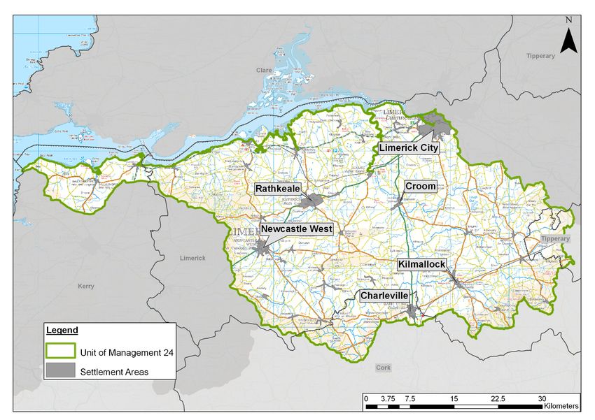
Document Control Sheet                                                                             BPP 04 F8
                                                                                                       Version 7 April 2011

Client:              Office of Public Works                  Project No: 3210300
Project:             Shannon CFRAM Study
Document Title:      Unit of Management 24: Shannon Estuary South
                     Flood History and Key Environmental Issues
Ref. No:             TD_ENVT_0316_V1_C_JAC_Env_Scoping_AnnexII_UoM24_120919

                      Originated by          Checked by            Reviewed by              Approved by
                       NAME                  NAME                  NAME                     NAME
 ORIGINAL
                       Muriel Ennis          Kelly                 Scott Johnson /          Peter Smyth
                                             Kasperczyk            Kelly Kasperczyk
                       Oonagh Duffy

 DATE                  INITIALS              INITIALS              INITIALS                 INITIALS

 July 2012             Document Status       Draft: Issue to OPW for Review

                       NAME                  NAME                  NAME                     NAME
 REVISION
                       Muriel Ennis          Oonagh Duffy          Denise Meade             Peter Smyth

 DATE                  INITIALS              INITIALS              INITIALS                 INITIALS

 August 2012           Document Status       Issue to OPW for Approval

 REVISION              NAME                  NAME                  NAME                     NAME
                       Oonagh Duffy          Denise Meade          Denise Meade             Peter Smyth

 DATE                  INITIALS              INITIALS              INITIALS                 INITIALS

 September
                       Document Status       Final Report for Consultation
 2012

Copyright
Copyright Office of Public Works. All rights reserved.

No part of this report may be copied or reproduced by any means without prior written permission from the Office
of Public Works. If you have received this report in error, please destroy all copies in your possession or control
and notify the Office of Public Works.

Legal Disclaimer
This report is subject to the limitations and warranties contained in the contract between the commissioning party
(Office of Public Works) and Jacobs Engineering Ireland Limited.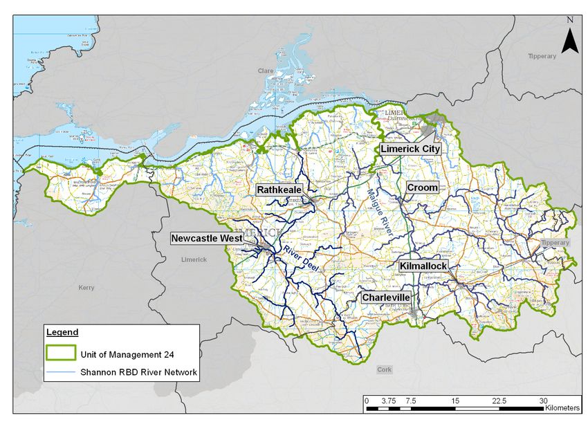
Contents

       1      Introduction                                                  2
       1.1    Background                                                    2
       1.2    Consultation                                                  3

       2      Unit of Management Characteristics and History of Flooding    4
       2.1    Unit of Management Characteristics                            4
       2.2    History of Flooding                                           6

       3      Key Environmental Issues in Unit of Management 24            10
       3.1    Introduction                                                 10
       3.2    Population and Human Health                                  11
       3.3    Geology, Soils and Land Use                                  16
       3.4    Water                                                        24
       3.5    Air and Climate                                              36
       3.6    Biodiversity, Flora and Fauna                                38
       3.7    Fisheries, Aquaculture and Angling                           45
       3.8    Landscape and Visual Amenity                                 49
       3.9    Material Assets (economic), Development and Infrastructure   51
       3.10   Tourism and Recreation                                       54
       3.11   Archaeology and Cultural Heritage                            57
       3.12   Conclusion                                                   61

       References                                                          62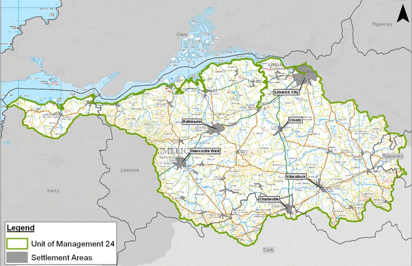
Annex II - Shannon Estuary South Unit of Management (UoM 24)

  1         Introduction

            1.1    Background

            As part of the Strategic Environmental Assessment (SEA) process, the Office of
            Public Works (OPW) invites you to give your views on the development and
            implementation of a series of Flood Risk Management Plans (FRMPs) in the
            Shannon River Basin District (RBD).

            This Annex represents a key element of the SEA scoping process for the proposed
            FRMP for the Shannon Estuary South Unit of Management (UoM 24) by
            describing the existing and potential future characteristics of the Unit of
            Management, summarising the history of flooding associated with its coastline and
            river catchments, and identifying the key social and environmental issues relating to
            flooding and flood risk management specific to this Unit of Management. This Annex
            should be read in conjunction with the overarching Shannon River Basin District
            Environmental Scoping Report which documents all other elements relevant to this
            scoping process.

            Your comments on the information outlined in this Annex, coupled with those on the
            overarching Shannon RBD Environmental Scoping Report, will assist the scoping
            of, and the consultation about, the environmental impacts of the Shannon Estuary
            South Unit of Management (UoM 24) FRMP by initiating the strategic environmental
            assessment scoping stage.

            The preparation of the FRMP for Unit of Management 24 will consider the risk of
            flooding from the rivers, estuaries and coastal waters at various different spatial
            scales. The locations that are considered to be potentially at risk of flooding, and
            therefore been identified as Areas for Further Assessment (AFAs) or Individual Risk
            Receptors (IRRs), will be subject to more detailed consideration in the development
            of the FRMP for this Unit of Management given their history of flooding, or where
            such risk might arise through future development or other changes/pressures.

            Flood maps indicating where flood risk from river, estuarine or coastal waters exists
            within AFAs or at IRRs, and along the watercourses connecting AFAs / IRRs will be
            produced for this Unit of Management.

                                                                                               2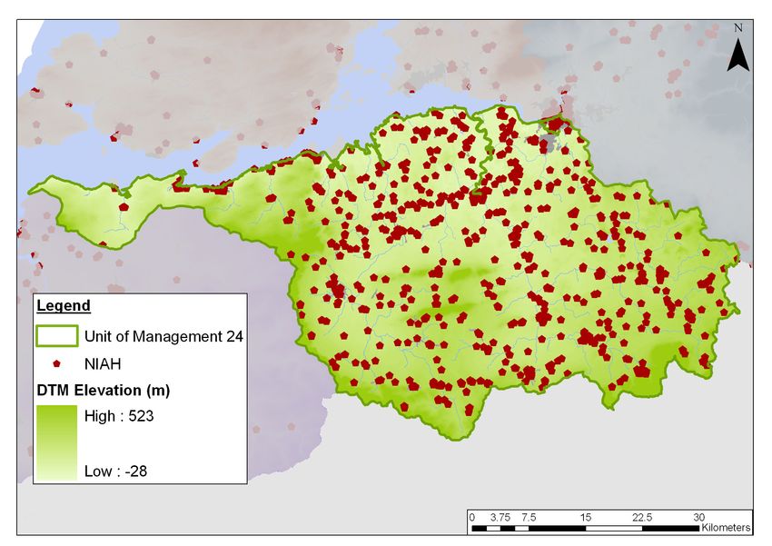
Annex II - Shannon Estuary South Unit of Management (UoM 24)

            1.2    Consultation

            You have an important role to play in helping us identify all the key issues relating to
            flood risk management, and we are keen to hear what you think. Specific to Unit of
            Management 24 (Shannon Estuary South), we welcome your comments on the
            key environmental issues.

            It is important to note that the information in this Annex accounts for pre-scoping
            consultation already undertaken with key organisations, and the following sections
            present our current understanding of the Shannon Estuary South Unit of
            Management. The SEA baseline and framework will develop as the Study
            progresses, and will be further informed by views and knowledge of stakeholders
            and the wider public.

            You can send us your views by email or by post to the details below.

                       Email                  shannon.cframs@jacobs.com
                       Write to               Shannon CFRAM Study
                                              Jacobs Engineering Ireland Ltd
                                              Merrion House
                                              Merrion Road
                                              Dublin 4
                       Telephone              01 2028113
                       Website                www.shannoncframstudy.ie

                                                                                                  3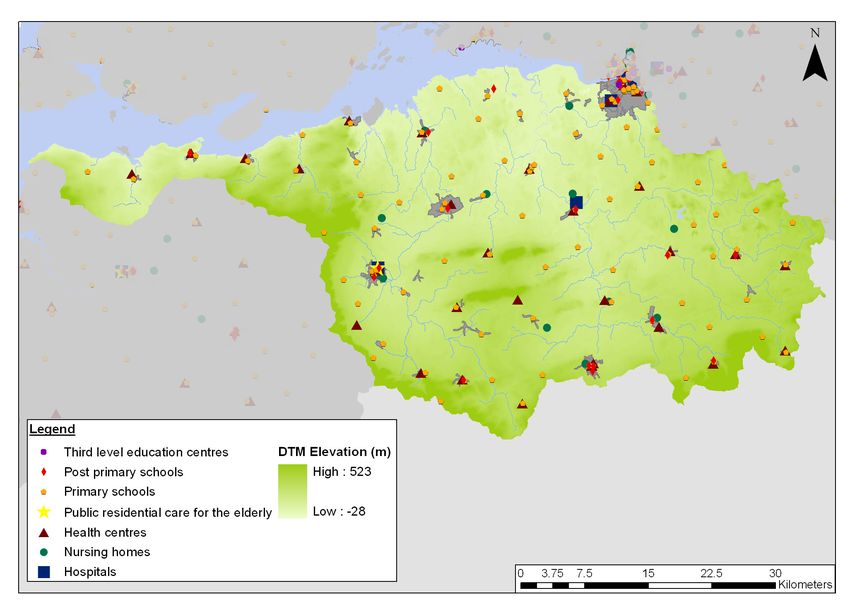
Annex II - Shannon Estuary South Unit of Management (UoM 24)

2 Unit of Management Characteristics and History of Flooding

            2.1    Unit of Management Characteristics

            The Shannon Estuary South Unit of Management (or UoM 24), shown in Figure 2.1
            encompasses areas of four counties; Kerry, Limerick, Cork and Tipperary. It
            consists of fertile limestone plain, known as the ‘Golden Vale’ bounded to the north
            by the Shannon Estuary and on the west, south and east by the Mulllaghareirk
            Mountains, Ballyhoura Mountains, Galty Mountains and Slieve Felim Mountains.

            Figure 2.1 - UoM 24 Shannon Estuary South Overview

            Unit of Management 24 is dominated by two main river catchments, the Deel and
            the Maigue, which together cover 65% of the Unit of Management area. The
            coastline extends along the Shannon Estuary from Limerick City in the east to
            where it meets the Atlantic Ocean between Loop Head (on the north of the Shannon
            Estuary in County Clare) and Kerry Head (County Kerry), to the west of this Unit of
            Management.

            The River Deel rises in the Mullaghareirk Mountains near Dromina. It flows roughly
            in a north-western direction though the mountains, where it is joined by numerous
            tributaries, including the Finglasha River and the Ahavarragh Stream which drain
            the lands upstream of Dromcolliher. Downstream of Newcastle West, the River
            Deel is joined by the Rivers Arra, Dooally and Daar, which drain the steep
            topography of the Knockanimpaha Mountains which bound the west of the
            catchment. Downstream of the this confluence, the River Deel flows north-east,
            through agricultural plains. The river roughly follows the direction of the N21
            towards and through the centre of Rathkeale. Flowing north from Rathkeale, the

                                                                                              4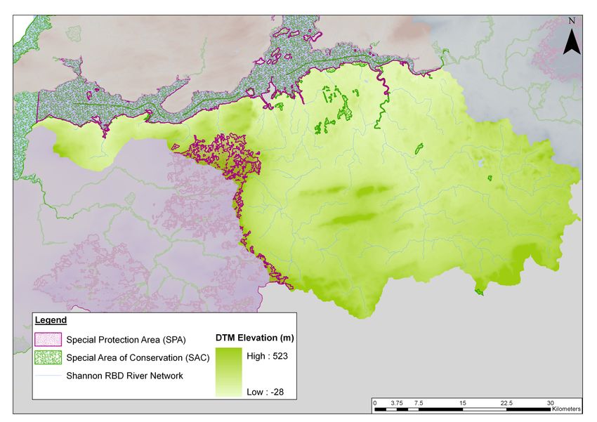
Annex II - Shannon Estuary South Unit of Management (UoM 24)

            Deel flows through Askeaton, and on to the Shannon Estuary. The total catchment
            area for the River Deel is 597 km2.

            East of the Deel catchment, and bounded to the north by the River Blackwater
            catchment, lies the Maigue catchment. The River Maigue drains an area of
            approximately 806 km2, from its source in the Ballyhoura Mountains (County Cork)
            to where it enters the Shannon Estuary approximately 10 km north of Adare.

            Rising north of Milford in north Cork, the River Maigue flows east to join the River
            Loobagh approximately 3 km north of Charleville, and then flows north through
            Bruree. Just downstream of Bruree, the Maigue is joined by the significant tributary
            of the Morningstar River, which drains a catchment area of approximately 132 km2.
            Continuing northwards, just upstream of Croom, the Maigue is joined by the third
            significant tributary of the River Camogue. From Croom, the River Maigue flows
            north-west towards Adare where the River Maigue becomes tidally influenced.

            Part of the River Feale Catchment lies within the north east section of this Unit of
            Management. This area of the catchment consists of a number of ‘short’ rivers
            which discharge directly to the Shannon Estuary.

            Arterial drainage schemes which are maintained by the OPW have historically been
            undertaken at various locations within the Maigue and Deel catchments for
            agricultural purposes.

            Spatial Scales of Assessment

            There are three Water Management Units (WMUs) within Unit of Management 24
            (refer to Figure 2.2). These consist of the Feale, Deel/Shannon Estuary and Maigue
            WMUs. Only approximately one third of the area of the Feale WMU (the northern
            part which borders the Shannon Estuary) is included in Unit of Management 24, the
            remaining area (specifically the Feale catchment) extends into Unit of Management
            23 (see Annex I).

            Table 2.1 and Figure 2.2 illustrate the AFAs and IRRs identified for Unit of
            Management 24, all of which may be subject to changes as the CFRAM Study
            develops.

            Table 2.1: UoM 24 spatial scales of assessment
                 County                    WMU                         AFA / IRR Name
             Areas for Further Assessment
                    Cork                   Maigue                        Charleville
                    Cork            Deel/Shannon Estuary                   Milford
                    Kerry                  Feale                        Ballylongford
                  Limerick                 Maigue                          Adare
                  Limerick          Deel/Shannon Estuary                 Askeaton
                  Limerick                 Maigue                         Clarina
                  Limerick                 Maigue                          Croom
                  Limerick          Deel/Shannon Estuary                Dromcolliher
                  Limerick                 Feale                          Foynes
                  Limerick                 Maigue                        Kilmallock
                  Limerick          Deel/Shannon Estuary               Newcastle West
                  Limerick          Deel/Shannon Estuary                 Rathkeale
             Individual Risk Receptor
                    Kerry                  Feale                    Tarbert (Power Station)

                                                                                              5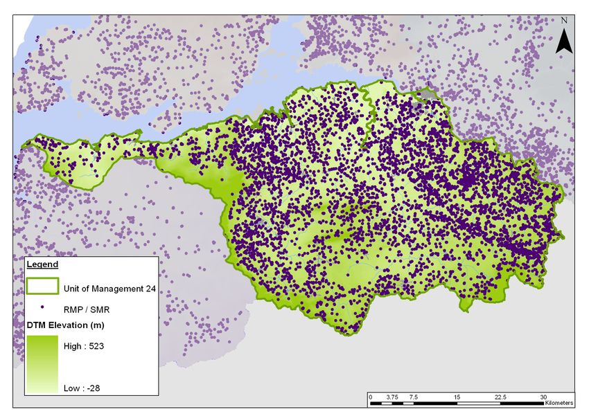
Annex II - Shannon Estuary South Unit of Management (UoM 24)

            Figure 2.2 - UoM 24 Spatial Scales of Assessment

            The full extent of the AFA defined for Limerick City lies within three Units of
            Management and includes all of the developed land within the contiguous urban
            area of Limerick, and all lands zoned for development in or adjacent to Limerick City
            (including areas that may be outside of the Limerick City Council jurisdictional
            boundary). For the purpose of this Study, this AFA will be assessed as part of Unit
            of Management 25-26 (Annex III). Any flood risk management options proposed for
            this AFA will therefore be documented within the FRMP for Unit of Management 25-
            26.

            2.2    History of Flooding

            Within Unit of Management 24, there are records of significant flooding that has
            occurred throughout the Feale, Deel/Shannon Estuary and Maigue WMUs from
            1946 to 2008, affecting a number of towns and villages. The major cause of
            flooding, based on the available records, appears to be fluvial and tidal.

            Tables 2.2 to 2.4 show the reported fluvial and tidal flood events for the AFAs and
            IRR currently identified within the Unit of Management 24 WMUs. This historical
            flooding information has been gathered using the OPW National Flood Hazard
            Mapping website (www.floodmaps.ie), and the National Preliminary Flood Risk
            Assessment (PFRA) Report (August 2011) produced by the OPW. The ‘known’
            main flood mechanism is not recorded for all flood events and is assumed for some
            records in the tables below (these are shown in italics).

                                                                                               6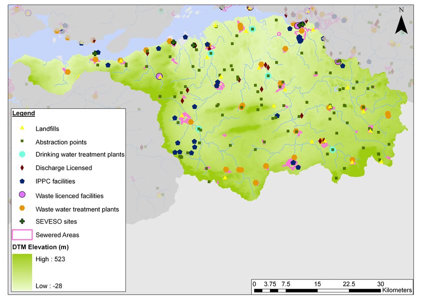
Annex II - Shannon Estuary South Unit of Management (UoM 24)

            Table 2.2:    Summary of historical flood events within the Feale WMU (for
                          those catchments that fall within UoM 24)
             FEALE WMU
             Flood Event        Main Flood Description of Flood Event
                                Mechanism
             (a) Ballylongford
             Jan 2004           Tidal             Gortnacooka Bridge area flooded.
             Apr 2002           Tidal             Land Commission Embankment LIS02/2104 flooded.
             Mar 2002           Tidal             Land Commission Embankment LIS02/1993 flooded.
             Feb 2002           Tidal             Kerry STW, street & some 10 houses flooded.
             Jan 2002           Tidal &           At least 12 houses at Bridge St, R551, R522, LA water
                                rainfall runoff   treatment plant flooded.
             Dec 2001           Tidal             Land Commission Embankment LIS01/1584 flooded.
             Aug 2001           Tidal             Carrig Island LIS01/769 flooded.
             Oct 1961           Tidal             Streets at Ballylongford flooded.
             Oct 1927           Tidal             A number of houses & streets flooded.
             (b) Foynes
             Jan 2005           Fluvial           At least 4 residential & 2 commercial properties
                                                  flooded. N69 affected.
             Feb 2002           Tidal             Domestic & commercial properties, main street & N69
                                                  flooded. 20 properties flooded (PFRA).

             Jan 2002           Fluvial           N69 & a number of premises flooded.
             Feb 1995           Fluvial with      N69 flooded for days.
                                tide locked
             Jan 1995           Fluvial           Flooding in the Railway Road area.
             Recurring          Fluvial           Morgan’s House flooded (from PFRA).
             (c) Tarbert Power Station IRR
                            -   -                 No recorded flooding

            Table 2.3:    Summary of historical flood events within the Deel/Shannon
                          Estuary WMU
             DEEL/SHANNON ESTUARY WMU
             Flood         Main Flood Description of Flood Event
             Event         Mechanism
             (a) Askeaton
             Recurring     Fluvial          Deel overflowed and flooded factory car park and L1236
                                            Road. No premises affected.
             (b) Dromcolliher
             Aug 1997      Fluvial          Houses & roads flooded.
             Jul 1997      Fluvial          Houses & roads flooded.
             Jun 1995      Fluvial          Houses & church flooded.
             Feb 1995      Fluvial          Roads flooded.
             Jan 1995      Fluvial          Roads flooded.

                                                                                                          7
Annex II - Shannon Estuary South Unit of Management (UoM 24)

             DEEL/SHANNON ESTUARY WMU
             Flood          Main Flood Description of Flood Event
             Event          Mechanism
             Dec 1994       Fluvial     Roads flooded.
             Jan 1994       Fluvial     Roads flooded.
             Dec 1993       Fluvial     Roads flooded.
             Sep 1993       Fluvial     Roads flooded.
             Jan 1993       Fluvial     Roads flooded.
             Nov 1991       Fluvial     Roads flooded.
             Dec 1990       Fluvial     Roads flooded.
             Feb 1990       Fluvial     Roads flooded.
             Jan 1989       Fluvial     Roads flooded.
             Oct 1988       Fluvial     Houses at Pike St and roads flooded.
             Feb 1988       Fluvial     Roads flooded.
             Jan 1988       Fluvial     Roads flooded.
             Aug 1986       Fluvial     Houses, church and roads flooded.
             Jul 1986       Fluvial     Roads flooded.
             Jan 1986       Fluvial     Roads flooded.
             Jan 1984       Fluvial     House at Pike Street flooded.
             (c) Milford
             -              -           No flooding details available.
             (d) Newcastle West
             Aug 2008       Fluvial     143 residential, 87 commercial properties & roads flooded.
             (e) Rathkeale
             1969           Fluvial     No flooding details available.
             Dec 1968       Fluvial     No flooding details available.
             Recurring      Fluvial     Graigue between Rathkeale & Ballingarry - land flooded on
                                        average once every 4/5 years. Area affected is between
                                        the R518 and L1213. Roads not flooded.
             Recurring      Fluvial     Lands to east of L1219 at Knockaunavad (north west of
                                        Rathkeale) flooded every winter.

            Table 2.4:     Summary of historical flood events within the Maigue WMU
             MAIGUE WMU
             Flood          Main Flood Description of Flood Event
             Event          Mechanism
             (a) Adare
             Feb 2002       Fluvial &   Land & road near Adare Station flooded.
                            Tidal
             Jan 1999       Surface     Station Road area affected by flooding.
                            Runoff &
                            Tidal
             Feb 1996       Tidal       N21 road flooded.
             Jan 1995       Tidal       Land & road flooded.

                                                                                                     8
Annex II - Shannon Estuary South Unit of Management (UoM 24)
MAIGUE WMU
Flood Main Flood Description of Flood Event
Event Mechanism
Dec 1973 Fluvial No flooding details available.
Aug 1946 Fluvial Agricultural land & roads flooded.
(b) Charleville
Aug 1946 Fluvial Houses & agricultural land flooded.
(c) Clarina
Sep 1992 Fluvial Fields flooded. The flood depth estimated to be 0.30m (1ft).
Recurring Fluvial Flooded a number of houses at Clarina Village.
Recurring Tidal No houses affected. Area flooded is over a length of 700 to
800m at toe of embankment.
(d) Croom
Dec 1998 Fluvial Houses flooded.
Aug 1997 Fluvial Houses flooded.
Jan 1995 Tidal Houses flooded.
Feb 1990 Fluvial Houses flooded.
Aug 1986 Fluvial Croom-Bruff Road (C1/31/4/2) & north of the road (C1/31/4)
flooded.
Dec 1983 Fluvial No flooding details available.
Dec 1973 Fluvial No flooding details available.
Aug 1946 Fluvial 15 houses flooded. Banogue (Croom) Creamery was
flooded.
Recurring Fluvial Caherass area of Croom affected by flooding.
(e) Kilmallock
Aug 1946 Fluvial Roads & one house flooded.
9Annex II - Shannon Estuary South Unit of Management (UoM 24)
3 Key Environmental Issues in Unit of Management 24
3.1 Introduction
The following sections provide a preliminary discussion of the environmental
baseline for Unit of Management 24.
Both the existing and potential future environmental characteristics of the Unit of
Management are summarised. These characteristics can influence the risk and
repercussions of flooding and can constrain or provide opportunities for the
implementation of strategic flood risk management options.
On developing the scope of the SEA for the Shannon CFRAM Study, and following
consultation with stakeholders, the key social and environmental issues relating to
flooding and flood risk management within Unit of Management 24 have been
identified, and these are documented in the following sections.
Potential interactions between the different aspects of the environment are outlined
within Section 5 of the overarching Shannon RBD Environmental Scoping Report.
These interactions will be further considered and documented during the later
stages of the SEA process.
10Annex II - Shannon Estuary South Unit of Management (UoM 24)
3.2 Population and Human Health
3.2.1 Current Conditions
Population
The population of Ireland was over 4.2 million in 2006 and provisional numbers from
the 2011 census indicate that population figures have increased by approximately
8.1% to 4.5 million. Ireland has experienced increasing population growth since
1961, however the past two years has seen a decrease in the demand for
development, and increased unemployment within this Unit of Management as is
the trend seen across the entire country.
The provisional 2011 census population figures currently available from the Central
Statistics Office (CSO) do not segregate city populations from rural population, but
these are due to be published in April 2012 and will be considered as appropriate in
the following stages of the SEA. Settlement patterns within this Unit of Management
are illustrated in Figure 3.2.1.
Figure 3.2.1 - Settlement patterns within UoM 24
Population figures reported in the 2006 census for the town boundaries of each AFA
within this Unit of Management are outlined in Table 3.2.1. As noted in Section 2.1
above, Limerick City AFA will be assessed as part of Unit of Management 25-26,
and therefore is not considered further within this report.
11Annex II - Shannon Estuary South Unit of Management (UoM 24)
Table 3.2.1: Population figures within the Areas for Further Assessment
(source: CSO)
Town (AFAs) Population 2002 Population 2006
Adare 1,102 982
Askeaton 921 979
Charleville 2,685 2,984
Clarina - 216
Croom 1,056 1,045
Dromcolliher 496 524
Foynes 491 606
Kilmallock 1,362 1,443
Milford 204 176
Newcastle West 4,017 5,098
Rathkeale 1,367 1,494
Many of the towns and villages within commuting distance from Limerick City have
experienced a higher population growth in recent years e.g. Newcastle West
(+1,081) and Rathkeale (+130).
Transport 21, the Government’s development programme for the network of
national roads over the period 2006 to 2015 included the following developments of
relevance to the population distribution within this Unit of Management:
• Atlantic Road Corridor from Letterkenny to Sligo, Galway, Limerick and
Waterford. This will connect the National Spatial Strategy’s, 2002-2020
Gateway Cities;
• Improve the key national primary routes, N21 from Limerick to Tralee and
N24 from Limerick to Waterford; and
• Targeted improvement of national secondary roads: the N69 along the
Shannon Estuary from Limerick to Tralee.
Transport 21 will be superseded by the new National Development Plan from 2012.
However, the NDP reflects many of the road infrastructural proposals under
Transport 21.
Human Health
Hospitals, health service centres, nursing homes and schools, as well as their
ancillary services and roads, are recognised as vulnerable receptors to flooding.
The distribution of these receptor groups throughout this Unit of Management is
illustrated by Figure 3.2.2.
The major hospitals servicing this Unit of Management are regional hospitals
located in Croom and Newcastle West. The regional hospital in Croom is located on
low ground and is considered to be a principal receptor in this Unit of Management.
Details regarding the existing and future characteristics of this Unit of Management
associated with pollution risks to human health are outlined in Section 3.4 of this
Annex.
12Annex II - Shannon Estuary South Unit of Management (UoM 24)
Figure 3.2.2 - Critical human health receptors within UoM 24 (source: OPW,
HSE)
3.2.2 Future Trends
Housing and Economic Development Planning
The Planning and Development (Amendment) Act 2010 (and subsequently the
Regional Planning Guidelines) includes new provisions for Development Plans,
requiring the introduction of a ‘core strategy that shall show that the development
objectives in the Development Plan are consistent, as far as practicable, with
national and regional development objectives set out in the National Spatial Strategy
and regional planning guidelines’. The Core Strategy of each plan must provide a
transparent evidence-based rationale for the amount of land proposed to be zoned
for residential and allied mixed-use zonings in the relevant Development Plan and
associated compliance with relevant EU Directives. The implementation of core
strategies (which is being monitored by the Mid-west and South West Regional
Authorities for this Unit of Management) within the Development Plans is likely to
result in de-zoning, re-zoning and phasing of development of lands.
Local Authorities with AFAs/IRRs within this Unit of Management, which include
Limerick, Cork and Kerry County Councils, have incorporated Core Strategies into
their Development Plans. Each Council are now required to integrate these
Strategies into the relevant Local Area Plans. The implementation of these
strategies may result in re-zoning or de-zoning of land within this Unit of
Management, influencing population distribution and development. Core Strategies
outlined in the Limerick (draft 2010 – 2016), Cork (2009 – 2015) and Kerry (2009 –
2015) County Development Plans emphasise the need for sustainable development
and appropriately zoned land, in addition to a strong link to enforcement of planning
regulations for sustainable development into the future. The strategies relevant to
the AFAs will be examined further in the next stage of the SEA process. In addition,
13Annex II - Shannon Estuary South Unit of Management (UoM 24)
consultation with relevant Regional Planning Authorities for this Unit of Management
will continue.
There is a requirement for planning authorities to have regard to the Planning
System and Flood Risk Management Guidelines (Department of Environmental
Heritage and Local Government1 and the OPW, 2009) in carrying out their functions
under the Planning Acts. This is to ensure that ‘where relevant, flood risk is a key
consideration in preparing Development Plans and Local Area Plans and in the
assessment of planning applications’. These guidelines aim to help revise and
strengthen planning policy on development and flood risk across Ireland, and will
therefore have a significant influence on future population and development growth
and distribution across the Unit of Management.
The preparation of a Strategic Integrated Framework Plan (SIFP) and its associated
SEA and AA for the Shannon Estuary has recently commenced. This Plan aims to
identify the nature and location of future development, economic growth and
employment that can be sustainably accommodated within the estuary whilst
ensuring that the habitat status of the Natura 2000 and other environmentally
sensitive sites would not be reduced as a result of the impacts of such
developments (for further information, refer to Section 3.9.2).
Regional Planning Guidelines – Population Targets
Population targets are outlined in the respective Regional Planning Guidelines to
assist planning authorities to decide on the extent of land to be zoned for
development (particularly residential development). Population targets indicate the
minimum population numbers for these locations to be used in determining future
development land requirements for the region, setting the context for city and county
Development Plans and Local Area Plans. While zoning should have regard to
these population targets, the Guidelines note that additional development may be
permitted where there is a clear need. The targets outlined in Table 3.2.2 below
provide an indication of future population distribution in this Unit of Management.
Table 3.2.2: Population targets set out in the South West and Mid-West
Regional Planning Guidelines for regions within UoM 24.
Predicted
2006
Area / Region 2016 2022 Increase
(Census)
2016-2022
Limerick County 124,265 147,081 157,065 9,984
Kerry County 139,835 165,470 174,378 8,908
Cork County 361,877 436,920 470,622 33,702
1
Now the Department of the Environment, Community and Local Government.
14Annex II - Shannon Estuary South Unit of Management (UoM 24)
Box 3.2: Population and Human Health – Key strategic issues relating to
flood risk management
• Population and development growth will potentially increase the
number of people at risk from flooding;
• Recent and emerging changes to planning and development
regulations/guidance and their associated influences on the
distribution of both existing and future population and development,
can provide opportunities for the avoidance or mitigation of flood risk
if appropriately enforced;
• Flooding can have significant social and socio-economic effects, such
as increased stress and anxiety for individuals and communities as
well as monetary impacts associated with ‘clean-up’ activities;
• Increased levels of resilience and resistance of infrastructure
protecting or managing human health to flooding is important to
support emergency planning and response e.g. hospitals, nursing
homes, health care facilities, etc;
• Access to healthcare and emergency services should be maintained
during flood events;
• Failure to protect or manage potential ‘at risk’ areas, can influence
property insurance policies and may also restrict development
potential;
• Publication of nationally / regionally consistent information relating to
flood risk will help towards standardising planning, development and
insurance policies;
• Good public access to information relating to flood risk can support
ongoing community and business resilience, which in turn can
provide opportunities for facilitating or enhancing the sustainability of
flood risk management; and
• It is acknowledged that local authorities are legally required to
undertake emergency planning and therefore this will not be
proposed as a flood risk management option by the CFRAM Study.
However, other aspects of strategic flood risk management can
enhance business and community emergency planning and continuity
frameworks, e.g. linking emergency planning frameworks with flood
forecasting, to provide flood warning.
15Annex II - Shannon Estuary South Unit of Management (UoM 24)
3.3 Geology, Soils and Land Use
3.3.1 Existing Conditions
Underlying this Unit of Management is a sedimentary geology of shale, sandstone,
siltstone and limestone, see Figure 3.3.1.
Figure 3.3.1 - Geology within UoM 24 (source: GSI)
As part of the Irish Geological Heritage (IGH) Programme, a partnership between
Geological Survey of Ireland (GSI) and the National Parks and Wildlife Service
(NPWS), the GSI have identified important geological and geomorphological sites
which could be conserved as Natural Heritage Areas (NHAs). Until designation is
confirmed, these sites are classified as Irish Geological Heritage Sites (IGHs).
There are 22 IGHs classified within this Unit of Management (refer to Figure 3.3.2
and Table 3.3.1).
16Annex II - Shannon Estuary South Unit of Management (UoM 24)
Figure 3.3.2 - Irish Geological Heritage Sites within UoM 24 (source: GSI)
Table 3.3.1: Description of the IGH within UoM 24
Theme Principal
Site Name Theme Type
No(s). Characteristics
Upper Carboniferous and Carboniferous Rocks
Beal Point IGH9
Permian Exposed
Carboniferous to Pliocene
IGH3 Carboniferous Lst.
Askeaton Quarry Palaeontology
IGH8 Waulsortian Quarry
Lower Carboniferous
Mellon House Beds and
Ballinleeny Quarry IGH8 Lower Carboniferous
Ringmoylan Shales
Ballylanders/Kilfinnane IGH7 Quaternary Moraine
Carrigogunnell (Massey's Volcaniclastics Lava
IGH8 Lower Carboniferous
Bridge - Newtown) Flows
Lavas and Varied
Cromwell and Kilteely Hills IGH11 Igneous Intrusions
Volcanic Rocks
Curraghturk IGH7 Quaternary Spillway
Deel River Section,
IGH8 Lower Carboniferous Waulsortian Mudbank
Askeaton
Derk Hill IGH11 Igneous Intrusions Volcanics
Foynes road section and
IGH8 Lower Carboniferous Gull Island Formation
inland outcrop
Grange IGH8 Lower Carboniferous Volcanics
Carboniferous to Pliocene
IGH3
Kilmeady Quarry Palaeontology Ballyvergin Shale
IGH8
Quaternary
17Annex II - Shannon Estuary South Unit of Management (UoM 24)
Theme Principal
Site Name Theme Type
No(s). Characteristics
Knockderc Hill IGH11 Igneous Intrusions Syenite
Knockroe IGH8 Lower Carboniferous Lava Tubes
Hydrogeology (including
Knocksouna Springs IGH16 Warm Spring
warm springs)
One of the Major Sites for
Lough Gur IGH8 Lower Carboniferous Sub-Fossil Remains of
the Giant Irish Deer
Mantlehill (Deel River
IGH8 Lower Carboniferous Waulsortian Mudbanks
Section)
Mungret Quarry IGH8 Lower Carboniferous Visean Shelf Lst. Quarry
St. Bridget's (Newcastle Hydrogeology (including
IGH16 Warm Spring
West) warm springs)
Hydrogeology (including
Tobergal IGH16 Warm Spring
warm springs)
Tory Hill (Lough Nagirra) IGH7 Quaternary Glacial Sediments
Knockderk IGH8 Lower Carboniferous Volcanic Plug
The soils are generally a mixture of gley, grey brown podzolics, and lithosols, soils
with more acid brown podzolics and peaty gley soils to the west and south of the
Unit of Management. The sub-soil consists of limestone till with shale’s / sandstone
till and cut-over peat to the western section of the Unit of Management. Figure 3.3.3
shows the type of sub-soils within this Unit of Management derived from the
underlying geology.
Figure 3.3.3 - Sub-soils within UoM 24 (source: Teagasc)
18Annex II - Shannon Estuary South Unit of Management (UoM 24)
Land use recorded within this Unit of Management is shown on Figure 3.3.4.
Based on data from Corine 2006, agriculture is the dominate land use within this
Unit of Management, accounting for 92% of land area. Dairy herds with some beef,
horse breeding, pig and poultry in certain areas are the main agricultural practices
(Limerick Country Development Plan), and arable land is the dominant land cover
type.
Figure 3.3.4 - Land use within UoM 24 (source: EPA Corine land cover
database 2006)
The remaining land use types consist of forestry and semi-natural areas (4%),
wetland, including peat bog (2%) and built land (2%). Peat bogs are more common
on higher ground to the west of County Limerick and in North Kerry. Additionally
there are twelve quarries and three mines identified within this Unit of Management.
The reform of the EU Common Agricultural Policy (CAP) provided the incentive for
the formulation of the Rural Environment Protection Scheme (REPS). The
overarching principle of the REPS was to reward farmers for undertaking farming
practices in an environmentally friendly manner. The uptake of the REPS
throughout Ireland is reported on a percentage uptake per county with the highest
percentage uptake being 30-35%. Within County Limerick and County Cork, the
uptake is 15-20%, and in County Kerry uptake is reported to be 30-35% (EPA
Envision Mapper). The Forest Environmental Scheme (FEPS) which is an ‘add on’
to REPS, provided incentives to farmers within REPS to plant woodland with
emphasis on environmental gain, rather than solely for economic gain. The
percentage uptake of FEPS (forest as a % of county area) for this Unit of
Management is 5-10% based on Co. Limerick figures (EPA).
In 2009 the REP Scheme ended, and 2014 will see the last of the REPS payments.
In 2010, the Agri-Environmental Options Scheme (AEOS) was rolled out, which
targets three environmental challenges; loss of biodiversity, improvement of water
19Annex II - Shannon Estuary South Unit of Management (UoM 24)
quality and combating climate change. This scheme also runs for 5 years, and early
REPS2 farmers can avail of this scheme. In 2011/12 an AEOS2 is being offered for
a period of 5 years, or until CAP reform in 2013. The CAP 2013 reform is still in
process, but ‘aims to maintain income stability for farmers, while farming with
respect to environmental, food safety and animal welfare standards’.
Farms within this Unit of Management are required to comply with Ireland’s
(second) Nitrates Action Programme which was given effect through a series of
Regulations3. This includes the implementation of Fertilisation Plans. These
Regulations support the protection of waters against pollution from agricultural
sources, e.g. by phosphorus and nitrogen.
Figure 3.3.5 illustrates the recorded forestry cover in this Unit of Management which
consists of mainly commercial plantation of conifers, owned by Collite. These tend
to be located on poor soils of the uplands, harvested on a rotational period of 40
years (WRBD, 20084). Forestry on the lowlands is dominated by small privately
owned forest plots. All forestry operations are required to be carried out in
compliance with the principles of Sustainable Forest Management (SFM), as
outlined in the Code of Forest Practice5 to promote sustainable forestry and to meet
high environmental, economic and social standard.
Figure 3.3.5 - Forest ownership within UoM 24 (source: Forest Service)
Previous flood relief programmes run by the OPW under the Arterial Drainage Acts
1945 and 1995, have shaped some the landscape within this Unit of Management.
Orginally implemented to protect agricultural land from flooding, this programme
2
REPS1, REPS2 and REPS3
3
The most recent being the European Communities (Good Agricultural Practice for the Protection of
Waters) (Amendment) Regulations 2011.
4
Western River Basin District (2008), Programme of Measures and Standards for Forest and Water
5
Forestry Service (2000) Code of Best Forest Practice – Ireland.
20Annex II - Shannon Estuary South Unit of Management (UoM 24)
was updated in 1995 to include urban areas. The OPW maintain all embankment,
weirs and bridges that were constructed under this programme.
There are some small tracts of bog, concentrated largely to the west of this Unit of
Management, which are predominately blanket bog. There are no Bord na Móna
bogs present within this Unit of Management. However a potential issue raised at
the stakeholder workshops, is that conventionally, peat harvesting of areasAnnex II - Shannon Estuary South Unit of Management (UoM 24)
In 2006, the European Commission adopted a proposal for a Soil Framework
Directive, to provide soil statutory protection and to recognise soil as an invaluable
natural resource. This is likely to influence land cover and land use practices. As of
early 2012, this Directive is still in the decision-making process within the European
Council.
Into the future, agriculture land-use within this Unit of Management is likely to
remain dominant; although the pattern and trends of this use will change to reflect
the reform of the CAP in 2013 (‘the CAP towards 2020’), compliance with the
Nitrates Regulations (Ireland’s Nitrates Action Programme is due to be reviewed for
a third time in 2013) and abolishment of the EU Milk Quotas8 in April 2015.
One objective of this CAP 2013 reform is to make agriculture competitive on the
world market; similarly the abolishment of the EU Milk Quotas is likely to make the
diary industry more competitive in Ireland. This is in line with the Food Harvest
Report 2020 recommendations, which aim to increase Irish agri-food export by
2020.
Coillte forests within this Unit of Management have individual management plans
that are derived from the Coillte Forestry Services District Strategic Plan 2011-2015.
This Unit of Management lies within the Lower Shannon District (S2) management
plan area, for which both environmental and economic objectives are set for the
management of the forests at local level for the next five years. Within this
management plan, Coillte recognise forests as being an important resource in the
role of moderating flooding at times of high rainfall. Water quality is also addressed
as ‘drainage and cultivation practices in Coillte forests are designed to minimise
their impact on local water’. Water protection areas (buffer zones) are also being
established in plantations at present.
The Government has made a commitment to increase the forest area to 17% of the
total land area in Ireland by 20309, which is likely to include areas within this Unit of
Management. As referred to in Section 3.3.1, all new forestry is managed in line
with the SFM principals, including a guideline of development of a buffer of natural
riparian vegetation along rivers and streams (Forestry Service 2000).
The Forestry Service have produced a Geographical Information System (GIS)
based Forest Inventory Planning System (FIPS) to act as an aid in the long term
spatial planning of national forest, and to provide guidance to forestry grants. This
data provides further detail to that provided by the CORINE database, such as tree
species.
The EPA has published a series of Codes of Practice and Advice Notes, the
implementation of which can influence geology, soils and land use in this Unit of
Management. Those of relevance in this context are:
• Code of Practice for Wastewater Treatment and Disposal Systems Serving
Single Houses (population equivalent < 10);
• The EPA Code of Practice: Environmental Risk Assessment for Unregulated
Waste Disposal Sites; and
• Advice Note No.6, Version 1; Restoring Public Water Supplies Affected by
Flooding.
8
S.I. No. 94/2000 — European Communities (Milk Quota) Regulations, 2000
9
CAP Rural Development Division Rural Development Programme Ireland, 2007-2013.
22Annex II - Shannon Estuary South Unit of Management (UoM 24)
Box 3.3: Geology, Soils and Land Use – Key issues relating to flood risk
management
• Flooding and flood risk management measure/options can potentially
adversely affect the productivity of agricultural land, and can lead to
changes/abandonment of land use;
• Agricultural practices can have both negative and positive effects on
flooding and flood risk management, for example:
• Negative: reduction in soil infiltration rates and available soil water
storage capacities, and increasing rapid runoff in the form of
overland flow;
• Positive: agricultural lands may help manage runoff and provide
natural storage areas whilst also providing opportunities for
biodiversity and potentially supporting agri-environmental schemes.
• Forestry-related land use practices (afforestation and deforestation) and
associated land drainage schemes can influence the conveyance of
water within the catchments;
• Changes of land use from agriculture to urban/semi-urban behind OPW
arterial drainage scheme embankments (originally constructed to protect
agricultural land) has increased flood risk in these areas; and
• Upland forestry practices can include significant drainage systems
resulting in sudden water losses for the area.
23Annex II - Shannon Estuary South Unit of Management (UoM 24)
3.4 Water
3.4.1 Existing conditions
The EU Water Framework Directive (2000/60/EC) establishes a framework for the
protection of both surface and ground waters. Transposing legislation outlines the
water protection and water management measures required in Ireland to maintain
high status of waters where it exists, prevent any deterioration in existing water
status and achieve at least ‘good’ status for all waters by 2015. This is currently
being achieved through the implementation of River Basin Management Plans
(RBMPs). The Shannon RBMP 2009-2015 was adopted in June 2009 and includes
Water Management Unit (WMU) Action Plans10 and a programme of measures
required to facilitate the achievement of the WFD objectives.
Surface Water
The surface water bodies within this Unit of Management are primarily associated
with the River Maigue and the River Deel catchments, but also includes part of the
Feale catchment and transitional (estuarine) and a coastal water bodies.
Rivers
The Maigue WMU Action Plan states that 35% of the rivers within its catchment are
classified as good status with the remaining water bodies failing to achieve the WFD
objectives. The Deel WMU Action Plan summarises that just 18% of its catchment
rivers are classified as good status. The Feale WMU Action Plan states that 55% of
the rivers within its catchment area are classified as good status, with the remaining
water bodies failing to achieve the WFD objectives
As noted above, a small section of this Unit of Management falls under the Feale
WMU Action Plan. Annex I (Tralee Bay – Feale Unit of Management (UoM 23)) of
this Environmental Scoping Report provides further detail on the pressures and
programmes of measure specific to this catchment.
The Maigue, Deel and Feale WMU Action Plans associate the following
anthropogenic pressures/activities with the current failure of the surface water
bodies to achieve the WFD objectives:
• Nutrient sources: Total Phosphorous predominantly from diffuse sources
(agricultural, unsewered properties and waste water treatment plants
(WWTPs));
• Point source pressures: such as WWTPs, integrated pollution and prevention
control (IPPC) facility discharges, Section 4 discharges (trade or sewage
effluent), waste facilities (Maigue only) and water treatment plants;
• Quarries and landfills;
• On site waste water treatment systems (OSWTS);
• Forestry (Feale only);
• Physical alterations (morphological pressures); and
• Abstractions.
10
WFD Ireland Document Store -
http://www.wfdireland.ie/docs/1_River%20Basin%20Management%20Plans%202009%20-
%202015/ShIRBD%20RBMP%202010/
24Annex II - Shannon Estuary South Unit of Management (UoM 24)
Each Action Plan outlines a programme of measures to be implemented in the
catchment areas, and in some instances at a regional or national level. Those of
relevance to flood risk assessment and management include:
• Point sources: WWTP upgrades, review of the current terms of discharge
authorisations;
• Diffuse sources: inspection / enforcement of the Good Agricultural Practice
Regulations and inspection programme of ‘at risk’ septic tanks; and
• Morphological pressures: Investigation of channelisation to establish if
supplementary measures are required to address water quality issues
associated with morphology. Channel enhancement measures to assist
recovery from this pressure are to be considered.
Implementation of these measures is now progressing so as to achieve the WFD
objectives and inform the next RBMPs (2015 – 2021). Some measures responding
to the WFD requirements were implemented prior to the completion of the RBMPs,
for example, the EPA are progressing with a revised WWTP licensing regime
implemented under the Waste Water Discharge (Authorisation) Regulations 2007.
Transitional (estuarine) and Coastal Waters
The Shannon RBD Transitional and Coastal Waters Action Programme reports that
the ‘Mouth of the Shannon’ water body is classified as high status. The Upper
Shannon Estuary, Shannon Airport Lagoon, Limerick Dock and Clonderalaw Bay
transitional water bodies are reported to be at good status. The Maigue Estuary,
Deel Estuary, Foynes Harbour, and Lower Shannon Estuary were classified as
failing to achieve good status.
The Shannon RBD Transitional and Coastal Waters Action Programme associates
the following anthropogenic pressures/activities with the current failure of the
surface water bodies to achieve the WFD objectives:
• Land based pressures - point source such as WWTPs, IPPC licensed
facilities, combined sewer and treatment plant overflows, Section 4 licensed
discharges, and also diffuse sources such as nutrient inputs.
• Marine Pressures – Morphological alterations and aquaculture:
• Maigue Estuary - Embankment;
• Foynes Harbour – Hard defences and port activities; and
• Aquaculture licence in the Lower Shannon Estuary.
The Shannon RBD Transitional and Coastal Waters Action Programme has outlined
a programme of measures to be implemented in the catchment areas, and in some
instances at a regional or national level. Those of relevance to flood risk assessment
and management include:
• Morphology (Controls on Physical Modifications): The Action Programme
notes that the DECLG are considering the introduction of new regulations to
control physical modifications in surface waters which may involve an
authorisation system where low risk activities may simply be registered and
higher risk works would be subject to more detailed assessment and more
prescriptive licences. Consultation with the DECLG has confirmed that they
are currently in the process of reviewing water legislation on a number of
25Annex II - Shannon Estuary South Unit of Management (UoM 24)
fronts, including controls on physical modifications however it may be some
time before the regulation concerning controls on physical modifications are
implemented;
• Implementation of the Shellfish Waters Pollution Reduction Programmes
(there is one such programme relevant to this Unit of Management - West
Shannon Ballylongford Pollution Reduction Programme (DECLG, 201011));
and
• Full implementation of existing legislation including the Bathing Water Quality
Regulations (including the development of Bathing Water Management
Plans), Water Pollution Acts, Water Services Act, IPPC regulations, Urban
Wastewater Treatment regulations, the Foreshore Acts and the Birds and
Habitats Directives (particularly the Appropriate Assessment process).
In addition, the anthropogenic pressures/activities and proposed programme of
measures outlined in the river WMU Action Plans discussed in earlier sections are
also relevant to the transitional and coastal water bodies within this Unit of
Management.
There are no significant lakes within this Unit of Management, and no specific
pressures or measures have been identified in the Shannon RBMP.
Overall Status
Figure 3.4.1 presents the current reported status of surface water bodies as
provided by the EPA November 2011. A large portion of the Unit of Management
rivers are failing to achieve good status (77%), with some stretches of the River
Deel at bad status (5%). All water body classification results are currently being
reviewed and updated with more recent monitoring data as part of the 2015–2021
river basin management cycle. These will be reviewed in consultation with the EPA
as the SEA process developments.
11
Pollution Reduction Programmes, Characterisation Reports and Maps:
http://www.environ.ie/en/Environment/Water/WaterQuality/ShellfishWaterDirective/ShellfishWatersFina
lCharacterisationReportsandPRPs/Clare-Kerry/
26Annex II - Shannon Estuary South Unit of Management (UoM 24)
Figure 3.4.1 - Classification of surface water bodies under the WFD within
UoM 24 (source: EPA)12
As defined by the EPA, the Biotic Indices or Quality (Q) Values is ‘a biological water
quality index based on the composition and abundance of macroinvertebrate
communities e.g. mayflies, stone flies, shrimps, snails, bivalves etc. present in
rivers, and their varying sensitivities to increasing levels of pollution’. There are 93 Q
Value monitoring stations within this Unit of Management. The Q Values recorded at
these stations are summarised in Table 3.4.1 below.
Table 3.4.1: Q Value and equivalent WFD Status recorded at the EPA
monitoring stations within UoM 24
No. of
Q Value* WFD Status Pollution Status Condition** UoM 24
Stations
Q5, Q4-5 High Unpolluted Satisfactory 0
Q4 Good Unpolluted Satisfactory 36
Q3-4 Moderate Slightly polluted Unsatisfactory 29
Moderately
Q3, Q2-3 Poor Unsatisfactory 26
polluted
Q2, Q1-2, Q1 Bad Seriously polluted Unsatisfactory 1
* These values are based primarily on the relative proportions of pollution sensitive to tolerant
macroinvertebrates (the young stages of insects primarily but also snails, worms, shrimps etc.) resident
at a river site (EPA13).
** ‘Condition’ refers to the likelihood of interference with beneficial or potential beneficial uses (EPA).
Note: One station in this Unit of Management was ‘unclassified’.
12
Water bodies classified as ‘pass’ are recorded as achieving good status, however prior to further
monitoring, the confidence in the data is not at the adequate level to classify these as ‘good’ status.
13
EPA (2007) River Quality Surveys: Biological (http://www.epa.ie/qvalue/webusers/)
27Annex II - Shannon Estuary South Unit of Management (UoM 24)
Figure 3.4.2 presents the location of the EPA Q Values monitoring stations and the
pollution status recorded at each station.
Figure 3.4.2 - EPA Q Value Monitoring Stations within UoM 24 (source: EPA)
Groundwater
The Shannon CFRAM Study is not assessing groundwater flood risk; however, the
potential for groundwater flood risk to contribute to flood flows is recognised.
Groundwater status within this Unit of Management is classified predominately as
good, however there are large areas classified as poor status. Figure 3.4.3 below
presents the current status of groundwater bodies classified for the purpose of the
WFD and areas of source protection for drinking water. Groundwater Protection
Schemes are county-based projects that are undertaken jointly between the GSI
and the respective Local Authorities. The aim of these schemes is to preserve the
quality of groundwater, particularly for drinking water abstraction purposes. The
Groundwater Protection Schemes within this Unit of Management shows 15 source
protection areas all located within Co. Limerick.
28Annex II - Shannon Estuary South Unit of Management (UoM 24)
Figure 3.4.3 - Classification of groundwater bodies under the WFD and Source
Protection Zones within UoM 24 (source: EPA)
The Shannon RBD Groundwater Action Plan associates the following anthropogenic
pressures/activities with the current failure of groundwater bodies to achieve the
WFD objectives:
• Point source pressures: Existing landfills and old dump sites (illegal landfill
sites), mines, contaminated land, and abstractions; and
• Diffuse source pressures: agriculture (nutrient loading), and OSWTS (septic
tanks in areas of high or extreme vulnerability or systems located at
unsuitable sites).
The Shannon RBD Groundwater Action Plan outlines a programme of measures to
be implemented in the catchment areas as follows:
• Nitrate Action Plan – Implementation of the Nitrates Action Plan and Code of
Good Agricultural Practices to reduce the level of pressure form diffuse
nutrient sources;
• IPPC Licensing – Remediation of contaminated land at IPPC licensed sites;
and
• OSWTS – Implement the EPA Code of Practice for Wastewater Treatment
and Disposal Systems Serving Single Houses (population equivalent ≤ 10)14.
Though not highlighted within the Shannon RBD Groundwater Action Plan it is also
recognised that the EPA licensing regime for WWTPs is a programme that could aid
in the achievement of the WFD objectives for groundwater bodies.
14
EPA 2000 Guidance is now replaced by EPA (2009) Code of Practice for Wastewater Treatment
and Disposal Systems Serving Single Houses.
29Annex II - Shannon Estuary South Unit of Management (UoM 24)
All the groundwater bodies in this Unit of Management and within the Shannon RBD
are designated as drinking water protected areas.
In terms of vulnerability (the likelihood of contamination if a contamination event
occurs), there are also areas of extreme vulnerability within this Unit of
Management, amounting to approximately 9% of the land area. In addition
approximately 11% of the land area is identified as rock near surface or karst.
These areas can be very vulnerable to infiltration and transportation of pollutants.
Figure 3.4.4 illustrates the groundwater vulnerability within this Unit of Management.
Figure 3.4.4 - Groundwater Vulnerability in UoM 24(source: GSI)
The Shannon RBD Groundwater Action Plan identifies one groundwater-dependant
terrestrial ecosystem (GWTE) located within this Unit of Management - Askeaton
Fen complex (SAC 0022279). GWTEs are habitat/species that are dependent on
groundwater to maintain the environmental supporting conditions required to sustain
that habitat and/or species15.
Registered Protected Areas
In accordance with the WFD, a Register of Protected Areas has been compiled for
the Shannon RBD. These areas are identified as those requiring special protection
under existing national or European legislation:
• Waters used for the abstraction of drinking water;
15
EPA (2008). A Framework for the Assessment of Groundwater-Dependent Terrestrial Ecosystems
under the Water Framework Directive.
30Annex II - Shannon Estuary South Unit of Management (UoM 24)
• Areas designated to protect economically significant aquatic species - These
are protected areas established under earlier EC directives aimed at
protecting shellfish (79/923/EEC) and freshwater fish (78/659/EEC);
• Recreational waters (none of which are designated within Unit of
Management 24);
• Nutrient Sensitive Areas (none of which are designated within Unit of
Management 24); and
• Areas designated for the protection of habitats or species (refer to Section
3.6 for details).
The locations of the Registered Protected Sites currently recorded for this Unit of
Management are illustrated in Figure 3.4.5.
Figure 3.4.5 - Registered Protection Areas within UoM 24 (source: EPA)
Activities / Pressures
Figure 3.4.6 illustrates the distribution of various activities within this Unit of
Management which can both influence and be influenced by the quality of water.
The majority of this data was collated for the purpose of the WFD (and reported
within the RBMPs 2009-2015) and is currently being updated by the EPA and Local
Authorities. Further information relating to these activities will be considered where
relevant in the next stages of the SEA.
A total of 28 facilities within this Unit of Management currently hold IPPC licences.
IPPC licences aim to prevent or reduce emissions to air, water and land, reduce
waste and use energy/resources efficiently.
31Annex II - Shannon Estuary South Unit of Management (UoM 24)
There are two waste transfer stations at Ballykeefe Town and Luddenmore, which
are licensed by the EPA, and a total of 21 landfills are located within this Unit of
Management (one of which is licensed by the EPA – Gortadroma).
Data supplied by the EPA indicated that there are 23 WWTPs within this Unit of
Management.
The EPA report ‘Focus on Urban Waste Water Discharges in Ireland (February
2012), includes a review of the operation of urban waste water treatment plants
(UWWTPs) that are the subject of an EPA waste water discharge licence
application. Within this Unit of Management, the status of these UWWTPs varies
from pass, fail and undetermined.
The majority of this Unit of Management is unsewered, with private sewerage
systems/septic tanks installed. There are a number of sewered areas within this Unit
of Management as indicated in Figure 3.4.6 including Charleville, Killmallock,
Newcastle West, Rathkeale and Limerick City (which will be considered as part of
Unit of Management 25-26)16.
Water Pollution Discharge Licences are issued under Section 4 of the Local
Government (Water Pollution) Act 1977 as amended in 1990 and refer to the
discharge of trade or sewage effluent to waters. There are 13 such discharges
within this Unit of Management.
16
This does not include any sewerage network connected to a sewage treatment plant with less than
500 p.e. as this was the threshold for inclusion in WFD risk assessments.
32Annex II - Shannon Estuary South Unit of Management (UoM 24)
Figure 3.4.6 - Estimated locations of licensed abstractions (as of 2008), IPPC,
waste licensed facilities, landfills, licensed discharges,
wastewater and water treatment plants, SEVESO sites and
sewered areas (source: EPA, GSI, HSE and Limerick / Kerry /Cork
County Council)
There are five water supply treatment plants within this Unit of Management, two of
which are within the Deel WMU and three in the Maigue WMU. Water supply
treatment plants are most likely to be located on the banks of rivers, and the EPA
has published guidance17 on post-flooding checks for Local Authorities to implement
at such plants.
The Control of Major Accident Hazards Involving Dangerous Substances
Regulations, 2006 (SEVESO Regulations) deal with dangerous substances in
industry, covering both industrial activities as well as the storage of dangerous
chemicals. There are two tiers to the legislation; Lower Tier for smaller facilities
using or storing hazard material, which requires a Major Accident Prevention Policy,
general duties and notification to relevant authorities, and an Upper Tier for large
facilities (requiring additional plans such as internal emergency plans and
notifications to the public). Within this Unit of Management there are three facilities
listed as SEVESO sites, two located at Foynes Port, Co. Limerick (Tier I and Tier II)
and one in Askeaton, Co. Limerick (Tier I).
Hydromorphology
The WFD requires that hydromorphological elements are considered when defining,
maintaining and improving water status. There have been some physical
(morphological) alterations to various water bodies within this Unit of Management
17
Advice Note No.6, Version 1; Restoring Public Water Supplies Affected by Flooding, EPA
(November, 2009)
33You can also read