Topic Areas - Kennebunk, ME
←
→
Page content transcription
If your browser does not render page correctly, please read the page content below
Topic Areas
Historical and Archaeological
Overview
Kennebunk, a designated Maine Certified Local Government, prides itself in its heritage and culture and
maintains its heritage through written records as well as its architectural structures and archeological sites. The
Town established a Historic Preservation Overlay District in 1963 as well as the Historic Preservation Commission
to preserve its architecture detailing various eras of significance and historic archeological sites. Federal, State
and Town preservation ordinances (Zoning Ordinance Article 8, Section 17; Article 12) are followed by the
Kennebunk Historic Preservation Commission which works with Town staff, Maine Historic Preservation
Commission and other local town historic commissions to ensure historic assets are maintained and protected.
The Kennebunk Town Historian is also used as a resource, especially for archeological issues. Significantly, the
Town recently supported several phases of an archeological survey of the freed enslaved-peoples settlement
site. The site was prized by the Maine State Archeologists for being previously undisturbed. The goal of the
project is to achieve historic designation status in the not-too-distant future.

Because of the irreplaceable nature and historic value of architectural and archaeological resources, they are
protected by town, state and federal laws. This includes structures or sites enrolled in the National Register of
Historic Places or are eligible for nomination to the register. Often archaeological resources are the only record
of towns’ historic heritage about women, children, black, indigenous, and poor inhabitants.

History of Kennebunk
Kennebunk has maintained a rich historical record of its development as a village and town through written
records and its architectural structures and archeological sites. In the Abenaki language, Kennebunk means "the
long cut bank," presumably the long bank behind Kennebunk Beach. The phrase, "Kennebunk, the only village in
the world so named," was originally featured on a large locally famous sign attached to the Kesslen Shoe Mill
and is still displayed on the Lafayette Center on Route 1.

A group of Kennebunk volunteers have begun research through several organizations to discover Kennebunk’s
early history prior to arrival of European colonists to add to the many existing histories written by our local
authors. Much of this pre-colonial history is difficult to uncover. The group is carefully researching native/tribal
views on issues as far back as possible. The tribes themselves did not think of territory and "ownership" of land
in the way that has been used to categorize them much later in time.

Kennebunk was first settled by European colonialists in 1621. In the very earliest days of colonization, “the
kennebunk“ was shared sacred land. The Abenaki people journeyed south as seasonal migrants from their
homelands each Spring to the “long cut bank.”

As early as the 1620s, a series of waterfalls on the Mousam River provided power for sawmills and grist mills,
and the Kennebunk River served as a port of entry and base for the building of wooden ships. Homes, churches
and mercantile uses clustered around these early centers of commerce, and rudimentary early roads were
created to allow teams of oxen and horses to haul loads of lumber from the western forest to supply the
burgeoning shipbuilding industry.

                                                         14
The Landing area between Lower Village and Downtown played a primary role in the town’s 18th and 19th
century shipbuilding industry and still shows visible remnants of this history, including a shipway and timbers
from an old dock. As the size of merchant ships increased in the 1850s and it became too difficult to maneuver
them downstream, shipbuilders moved their enterprises to Lower Village. An article in the Eastern Star
Newspaper, dated 2 April 1915, lists all of the ships built in Kennebunk Landing from 1800 until 1885. The first
ship was built in 1755 on the Kennebunk River at Mitchell’s Wharf by John Bourne. The list was created by Seth
E. Bryant and a copy of the article can be found at the Brick Store Museum or at its website:
www.brickstoremuseum.org

Kennebunk was part of the town of Wells until 1820, when it incorporated as a separate town. By 1835, four
distinct village centers had emerged: Mousam Village, the most populous of the village centers, which bordered
“the turnpike” that would later become Route 1; Lower Village, at the mouth of the Kennebunk River and home
to many wharves used by coastal shipping vessels; the Landing, center of the early shipbuilding trade; and the
Plains-Alewive farming community. Small farms filled the areas between the villages, and houses were built
along the expanding network of roadways. In 1842, the Portsmouth, Saco and Portland railroad line came
through the western part of Kennebunk, and a depot was built next to the twine mill at Middle Falls, which
resulted in the creation of Kennebunk Depot (later renamed West Kennebunk), a small village with eateries,
lodging and stores to support the needs of residents, workers and travelers.

Mousam Village continued to grow
with the advent of a thriving
manufacturing complex along the
Mousam River in the Water Street-
Brown Street-Route 1 area,
producing a variety of products
including twine, cotton, thread,
doors, sashes and blinds, and shoes;
nearby worker housing began to mix
with the grander homes along             Factories along the Mousam River – late 1800s Photo credit: Brick Store Museum
Summer Street owned by ship
merchants. Among the firms doing business there were the Kennebunk Manufacturing Company, the Mousam
Manufacturing Company, the Leatheroid Company and the Rogers Fibre Company. Stores and community
gathering places opened along Main Street. In the 1870s the Boston & Maine Railroad laid tracks from South
Berwick through Kennebunk to Portland, with a new station off Summer Street that delivered tourists to newly
built hotels and cottages being developed by the Boston and Kennebunkport Seashore Company. Inter-town
travel was further extended during the 1899 to 1927 period when Kennebunk was a stop on the Atlantic
Railway, a trolley line that connected many York County points.

Lower Village initially served as a coastal shipping point, and later supplanted the Landing for shipbuilding, until
the era of wooden ships and their construction largely came to an end in 1918. Its next role, as a destination for
the growing tourist trade, was cemented in 1883 when a 4.5 mile Boston & Maine branch line along Kennebunk
Beach into Lower Village opened the area to development of hotels, summer homes and supporting mercantile
establishments. As automobiles began to dominate the transportation scene and roads were paved, train
ridership declined and in 1926 the Lower Village branch line was abandoned.

Most of the industrial businesses disappeared by the early to mid-20th century leaving fishing, small
independent businesses and tourism to become the primary commercial enterprises. The Town’s historic
architecture became a prominent feature of the cultural development of Kennebunk and led to the creation of

                                                           15
the Kennebunk Historic Preservation Overlay District in 1963. The district’s role in the development of Maine’s
coastal tourism industry has continued to grow.
Kennebunk’s Historic District
During the 1960s, recognition that historic properties were worthy of protection and preservation resulted in
the creation of historic districts in
many towns and cities across the
country. In Maine, Kennebunk’s
Summer Street had the distinction
of becoming the state’s first
Historic District, established in
1963. The district was listed on the
National Register of Historic Places
in 1974 (Information System ID
74000324). Its boundaries begin
300 feet from the centerline of
Portland Road from Barnard’s
Tavern at the north to Bourne
Street on the south, including properties on Fletcher Street which fall within the 300 foot boundary; all
properties on Dane Street, Elm Street, Green Street; and properties on Summer Street from Portland Road to
Durrell’s Bridge Road. This district contains fine examples of early architecture, the most famous of which is the
Wedding Cake House, a Federal-style dwelling extensively decorated with scroll saw Gothic trim. It has often
been listed in travel websites and periodicals and has a reputation for being the most photographed home in
Maine.
In 1994, the local Historic Overlay District was expanded to include properties below Durrell’s Bridge Road to Old
Port Road on the Kennebunk River side of Summer Street and properties on the north side of Port Road. The
expanded area of the Historic Overlay District includes land on the
north side of the street down to the Mousam River. This expanded
area is not included in the National Register.
Also in 1994, the Lower Alewive National Register District became part
of the National Register (System ID: 94000178). The district includes a
row of four farmsteads on the north side of Emmons Road, east of the
junction with Route 35 in West Kennebunk, and consisting of 208
acres. The farmsteads include: 1) Smith Farmstead (built c.1753,
added to NR 1982), 2) Walker-Russell Farm (c. 1797), 3) Seth Emmons
Farm (1840), and 4) Collins Emmons Farm (c. 1870).
In addition, the following properties and districts in the National
Register of Historic Places were identified in the May 2020 State of
Maine Inventory for the Growth Management Plan:
Kennebunk Historic District
Bourne Mansion, 8 Bourne Street (Built in 1812)
James Smith Homestead, Route 35 (Built in 1753)
William Lord Mansion, 20 Summer Street (Built in 1822)
Lower Alewive Historic District
16
Wallingford Hall, 21 York Street
Kennebunk High School, 14 Park Street (repurposed and now managed as the Park Street School
Apartments)
The following properties may also be eligible for listing in the National Register:
Chestnut Hill Farm, 617 Alewive Road
Fairview Farm, 164 Alewive Road
Goodall Worsted Company/Kesslen Shoe Company (now Lafayette Center), 2 Storer Street
Maple Top Farm, 885 Alewive Road
Houses at 34 and 54 Fletcher Street
JJ Keating Antiques, 70 Portland Road
Houses at 57 and 59 Fletcher Street
Farmsteads at 584 and 785 Alewive Road
Farmstead, 89 High Street
Joseph Curtis House, 7 Water Street
Alewive House Antiques, 756 Alewive Road
Upper Dam, Mousam River, Main Street
Riverhurst Farm, 226 Western Avenue
Franciscan Guesthouse, Beach Avenue
House and Barn, 25 Beach Avenue
Houses at 1, 3 and 17 Beach Avenue
Surveys
Architectural surveys have been conducted for assets within the Historic Preservation Overlay District
periodically. No professional town-wide surveys for historic archaeological sites have been conducted to date in
Kennebunk. Most recently, survey work began involving Free Black Community structure and cemetery.
Documentary research conducted by town historian, Kathy Ostrander Roberts, found the settlement was
formed soon after Massachusetts (including Maine) emancipated its enslaved people in 1783. Close to 20
individuals were present by 1800, but around 1831 the site was abandoned following the death of the last
recorded resident. An archaeological survey permitted by the Bureau of Parks and Lands and funded by the
Kennebunk Bicentennial Committee successfully identified the location of two houses. Excavation of one of
these in 2018 and 2019 found evidence of at least two structures. Over 100 artifacts have been placed
on exhibit at the Brick Store Museum in downtown Kennebunk. Excavation of the site continues into 2021.
Future archaeological surveys should focus on the identification of potentially significant resources associated
with the town’s maritime, agricultural, residential, black and indigenous communities and industrial heritage,
particularly those associated with the earliest Euro-American settlement of the town in the 17th and 18th
centuries. Mousam River and Maine coast and islands need professional prehistoric archaeological surveys.
Sandy soils in the Kennebunk plains region are sensitive and need surveying before subdivision or construction
permit approval.
Protecting Kennebunk’s Downtown and Historic Character
Maine Downtown Center’s (MDC) presented a report to the Town with recommendations and suggestions to
enhance future development of Kennebunk’s downtown. One recommendation was to extend the Historic
Preservation Commission’s design review authority to the entire “Main Street” commercial district. The MDC
emphasized the importance of the town’s irreplaceable buildings, their character-defining value, and their
17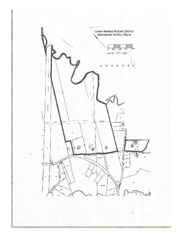
potential to leverage the benefits of incentives such as the federal and state historic tax credits to restore and
preserve them well into the future. The report stated that historic preservation is a proven economic
development tool that can significantly raise the level of revitalization.

During public participation sessions, residents rated the Town’s natural resources as extremely important to
quality of life, but equally important to them was the “built environment” – historic buildings, streets, parks,
walkable Downtown – features that contribute to what is described as “small town charm.” Currently, the
integrity of historic homes that make up identifiable and familiar streetscapes is protected only in the Historic
District. No ordinances prevent the demolition of historic houses during re-development projects in other parts
of town, and when homes are removed, residents register their disapproval, and the discarded materials burden
regional landfill capacity.

A survey question posed to residents asked, “Should the Town expand the Historic Preservation Overlay District
to include additional areas?” In response, 34% said Yes, 38% said No, and 26% had no opinion. Also important to
residents was the goal of “making the Downtown a viable destination” and “keeping Kennebunk’s small-town
appeal.” Given these statements, further public discussion about selective inclusion of parts of Downtown into
the Historic Overlay Zone, or creation of Design Standards for the Downtown, may be warranted.

Kennebunk Historic Preservation Commission
Preservation is defined as the act or process of applying measures necessary to sustain the existing form,
integrity, and materials of a historic property. Work, including preliminary measures to protect and stabilize the
property, generally focuses upon the ongoing maintenance and repair of historic material and features rather
than extensive replacement and new construction. This approach also offers a significant benefit for reducing
the carbon footprint compared to that of new construction.

The Historic Preservation Commission bases its decisions for granting a “Certificate of Appropriateness” on the
Kennebunk Historic Preservation Overlay District Design Guidelines, available at www.kennebunkmaine.us. Hard
copy books are available at the Town Hall. Also used is the Secretary of the Interior Standards for the Treatment
of Historic Properties. Its most recent (2017) standards and recommendations for historic preservation,
rehabilitation, restoration, and reconstruction are available through the U.S. Department of the Interior National
Park Service, Technical Preservation Services. Link: www.nps.gov/tps/standards/treatment-guidelines-2017.pdf

The Historic Preservation Commission was also founded in 1963 to “promote, encourage, and assist the
educational, cultural, economic, general welfare, and amenity of Kennebunk through the preservation and
protection of qualifying sites, buildings, and districts…through their maintenance as landmarks in the history of
Kennebunk, York County and Coastal North America…” Kennebunk’s Historic Preservation Overlay District
(KHPOD) is the oldest historic district in the State of Maine. To assist new property owners, the Historic
Preservation Commission has produced a letter to Realtors in Kennebunk for prospective buyers in the historic
district advising them of what property ownership involves within an historic district.

As a result of establishing the Historic Overlay District and the Historic Preservation Commission, Kennebunk
was granted status as a Certified Local Government (CLG) in February 1990 with the approval of the National
Park Service. Kennebunk is one of only 10 cities or towns in the State of Maine to be certified as a CLG. This CLG
status affords the Town of Kennebunk access to funding in the form of grants and tax abatements for historic
properties that require significant repair/maintenance, technical assistance from national and state historic
preservation programs/funds, and annual workshops for commission members, planners, elected officials and
other preservationists.

                                                         18
The Historic Preservation Commission consists of five members and two alternate members. Members are
appointed by the Select Board based on a demonstrated interest, knowledge or training in fields closely related
to historic preservation that include architecture, history, landscape architecture and archeology. Each Historic
Preservation Commission commissioner or alternate serves without pay and for a term of not less than three
years or such longer term as the Selectmen may determine. The Historic Preservation Commission strives to be a
resource as well a regulatory commission for working with the Town and its residents.

The Kennebunk Historic Preservation Commission has approved the introduction of alternative construction
materials and accepted them for projects where original materials could not be duplicated. The new products
are visually identical matches to profile, sheen, and texture of the original structural components, with the
benefit of high quality and extended life. Many of the new materials and technologies are accepted as a result of
consulting with the Maine Historic Preservation Commission and the Department of Interior. Each case involving
the use of alternate materials and technologies is reviewed on a case-by-case basis.

Despite resources available to owners of historic homes to perform maintenance and repairs, the cost of owning
such a home can be a large financial burden. At any given time, some historic homes will be in need of painting
or repairs. At the time of this writing, the notable example of a home that requires repairs is the venerable and
much revered Wedding Cake House. Extensive restoration work of this property is ongoing. The project may
involve public and private cooperation to ensure the renewal of a valuable historic asset for Kennebunk and for
Maine.

Guidelines defining responsibilities of owning property within a Historic Overlay District are available online and
in hardcopy. Historic buildings need proper care and rehabilitation to correct deferred maintenance and/or
unsympathetic changes that have occurred over time. There may be financial hardships incurred in maintaining
or rehabilitating historic properties. Residents researching historic guidelines through Federal and State
websites will discover that Maine Historic Preservation Commission and the U.S. Department of Interior
currently make several grants available to property owners for rehabilitation and preservation of structures
within historic districts. These grants as well as Federal Tax Credits can be acquired by property owners.
Additional information on grants and tax credits can be found at www.maine.gov/mHistoric Preservation
Commission.

In addition to the Historic Preservation Commission, Kennebunk has an official Town Historian, Kathy Ostrander
Roberts, who created the Museum in the Streets program, which resulted in the installation of 26 informational
panels at historic locations throughout the community. She is the author of two books on Kennebunk’s history
and writes history-based columns for local newspapers.

Cemeteries
Several years ago the now-defunct Kennebunk Cemetery
Committee completed a project to inventory all town cemeteries,
and located no fewer than 84 cemeteries. These range from small
family plots on private property to larger public cemeteries. Of
these, 36 contain one or more veteran graves; 12 may contain
veteran graves but require genealogical research; 14 have veteran
graves in poor to extremely poor condition; and 22 have no known
veterans, but are in degraded conditions. Many date back to
Kennebunk’s earliest days. There is currently no Town budget            Hope Cemetery

                                                        19
devoted to maintenance of veteran plots or abandoned cemeteries, many of which are on private land. The
American Legion places flags on all veteran graves for Memorial Day at the five main cemeteries in town.
The increasing trend towards cremation and scattering ashes – 72% in Maine - is putting financial strain on
cemeteries. To avoid having to turn over upkeep responsibilities to the Town, some are establishing innovative
partnerships to enable them to maintain upkeep responsibilities and provide public benefits to the Town, such
as parks and walking trails. An example is the 100 acre Hope Cemetery, located just north of downtown, which
devotes 72 acres of forest and field with two miles of trails including handicapped accessible portions, protected
through a conservation easement held by Kennebunk Land Trust.
Archeological Assets in Kennebunk
Urban Archaeology is the systematic recovery and examination of material
evidence from a town’s past. Remnants of human activity - structures, artifacts,
and other remains - which are often buried under subsequent layers of
development, illuminate and augment the information already available through
historical documents.
To date, 33 historic archaeological sites have been
documented for the town, including shipyards,
bridges, structures and shipwrecks. A number of
shipwrecks occurred in Kennebunk over the last
few centuries. These, at times, have been
unearthed on Gooch’s Beach and Mother’s Beach
after severe storms. The following ships sunk or
ran aground in the waters off of Kennebunk: Ship remains at Mother’s Beach
• Merchant - This 139-ton brig was built on the Kennebunk River by shipbuilder Nathaniel Gilpatrick and
launched October 13, 1804. She was cast away on the Kennebunk sandbar in April 1820.
• Colombia - Owned by Joseph Moody, Richard Gilpatrick and Jeremiah Paul, this 160-ton brig launched
upriver just a week after the Merchant. She sank in November 1818.
• Horace - A 389-ton barque that was built in Scarborough in 1827. The ship was lost off Kennebunk’s
Boothby’s Beach (now Mother’s Beach) in May 1838.
• Industry - The coasting packet Industry was the first vessel ever built in St. George by Irish shipbuilders.
Her captain was David Patterson II. Built in 1770, she was lost on her maiden voyage.
Registered Historic Sites
Site Name Site Number Site Type Periods of Significance Nat. Reg. Status
Corwin-Hawthorne Company ME 222-001 Mill, Sawmill, Grist 1676-1725 (1679-1688) Undetermined
Mill workshop,
blacksmith
Fort Larrabee ME 222-002 Military, fort 1735-1762 Undetermined
Nathaniel Gilpatrick House ME 222-005 Domestic and 1788-1824 Undetermined
shipyard
David Little Shipyard ME 222-008 Shipyard 1807-1833 Undetermined
Lyman-King-Bourne Shipyard ME 222-009 Shipyard 1776-1805 Undetermined
Joel Larrabee, Jr. Shipyard ME 222-010 Shipyard 1806-1814 Undetermined
William Taylor Shipyard ME 222-011 Shipyard 1800-1816 Undetermined
20Joel Larrabee 2nd ME 222-012 Shipyard 1815-1827 Undetermined
George and Ivory Lord ME 222-013 Shipyard 1817-1828 Undetermined
Shipyard
Tobias Lord Shipyard ME 222-014 Shipyard 1790-1808 Undetermined
Adam McCulloch Shipyard ME 222-015 Shipyard 1820-1822 Undetermined
Bourne McCulloch Shipyard ME 222-016 Shipyard 1804-1810 Undetermined
McCulloch Shipyard ME 222-017 Shipyard 1811-1816 Undetermined
Lyman-Kingsbury residence ME 222-018 Domestic Early 19th century Undetermined
Spofford ME 222-019 Domestic and 18th-19th centuries Undetermined
shipyard
Wentworth Dike ME 222-025 Dike Building date unknown Undetermined
Mousam Railroad Bridge ME 222-026 Bridge, railroad 1807 Undetermined
Kennebunk Railroad Bridge ME 222-027 Bridge, railroad 1897 Undetermined
Cabin (unidentified) ME 222-029 Sporting camp After circa 1865 Undetermined
Parson Cistern ME 222-030 Cistern 1920s-1930s Undetermined
Free Black Community ME 222-031 Domestic Documentary records, Eligible
Structure 2 emancipation 1789, death
of last occupant 1830s
Free Black Community ME 222-032
Structure 1
Black Chance Home ME 222-033
Source: May 2020 Inventory for the Growth Management Plan
Shipwrecks
Site Name Site Number Site Type Periods of Significance Nat. Reg. Status
Mary Agusta ME 222-003 Wreck, schooner 02 July 1914 Undetermined
Empress ME 222-004 Wreck, schooner October 1891 Undetermined
“Industry” ME 222-006 Wreck, packet 1790 Undetermined
Horace ME 222-007 Wreck, bark 1838 Undetermined
Arundel Wreck ME 222-020 Wreck, derelict Pre-1900 Undetermined
Monastery Wreck ME 222-021 Wreck, derelict Pre-1900 Undetermined
Elia Clifton ME 222-022 Wreck, schooner Built 1872, wrecked Undetermined
August 17, 1882
Breakwater Wreck ME 222-023 Wreck, vessel Unknown, Brig Columbia Undetermined
(1818(?)
Carrie G. Crosby ME 222-024 Wreck, schooner Built 1869. Removed from Undetermined
ship registry 1893
Phyllis A ME 222-028 Wreck, gill-netter Built 1925 Undetermined
Source: May 2020 Inventory for the Growth Management Plan
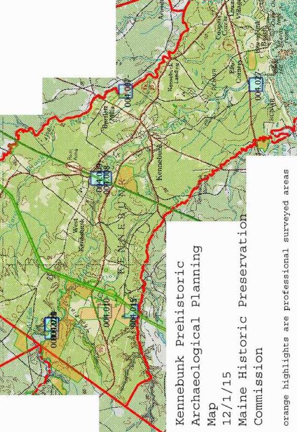
Pre-Historic Archeology
Article 12 of the Kennebunk Zoning Ordinances permits the Historic Preservation Commission to request
surveys of properties and sites thought to have historical significance, and Article 10, Section 3N addresses
archeological sites stating “any proposed land use activity involving structural development or soil disturbance
on or adjacent to sites listed on or eligible to be listed the National Register of Historic Places, as determined by
the permitting authority, shall be submitted by the applicant to the Maine Historic Preservation for review and
comment. Developers must appear before the Planning Commission and/or the Site Review Board which will
review applications for environmental plans and ensure that any construction or soil disturbance meets
requirements involving possible pre-historic or historic archeological site. This also includes structures or sites
enrolled in the National Register of Historic Places or are eligible for nomination to the register. Archaeology is
21often the only source of knowledge
about prehistory and the largely
undocumented lives of women,
children, native, minority,
immigrants and the poor.” According
to the May 2020 Inventory for the
Growth Management Plan (Dataset),
nine prehistoric sites are known:
Sites 04.07 through 04.10,
04.15, 4.19-4.21, 14.27 and
05.11.
Site 04.09 was located in
Turnpike right-of-way, and
has been completely
excavated by Maine Historic
Preservation Commission.
Site 04.10 and 04.15 located
on the Kennebunk Plains.
Other sites are located on
Mousam River floodplain, three of which were discovered during survey for a Land for Maine’s Future
conservation purchase.
Site 4.27 is a historic report of a prehistoric site on an historic property, apparently destroyed by
construction of formal gardens.
Threats to Historic Sites
As residential construction has increased within Kennebunk, in some cases that has meant the demolition of
older homes to construct new homes. The cost of maintaining an older home can result in deferred care and
neglect that negatively impacts building integrity, as well
as the availability of appropriate materials to maintain
original exterior aesthetics. The Town monitors
development and construction to protect historic sites,
but there is concern among residents for the historic
atmosphere/culture of the town.
In assessing risk to historic and archaeological sites and
structures, sea level rise storm surge with an increase of
astronomical tides would pose the most substantial
threat. Climate change resulting in extreme rain or ice
storms and winter weather can cause damage to historic
homes and buildings that might not be immediately
visible, but over time result in decay. The map to the left
indicates how a 1.6 ft. rise in tides will impact historic
areas along the Kennebunk and Mousam Rivers as well as
beach shorelines. A survey of historic and pre-historic sites
will help identify additional sites that may be at risk.
22Additional Tidal Threat Maps depicting higher Astronomical Tides can be found at:
https://www.maine.gov/mhpc/home
Goals, Policies and Strategies
State Goal:
To preserve the State’s historic and archeological resources.
Local Goal:
To conserve and promote Kennebunk’s unique identity and small town character by protecting the
Town’s historic and archeological resources.
Policy:
To manage growth and development in areas of historic significance to protect historic and prehistoric
archeological sites or historic structures, including within the Historic Preservation Overlay District, and
to promote an inclusive history of Kennebunk.
Strategies:
Timeframes: Short term = 0-3 years; Medium term = 3-5 years; Long term = 5+ years
Description Timeframe Responsible Parties
Continue to require developers to take appropriate measures to Ongoing Required by
protect known historic archeological sites and areas sensitive to Performance Standards
prehistoric archeology, including but not limited to, modification of
the proposed site design, construction timing and/or extent of
excavation, via zoning ordinance
Continue to follow and update ordinances to remain in compliance Ongoing Required by
with Maine’s subdivisions statute (30-A MRSA 4401-4407) Performance Standards
recommending review of impact on “historic sites" (Section 4404(8),
which includes both National Register listed and eligible buildings
and archaeological sites and coordinate with Town Historian and the
Historic Preservation Commission to ensure archaeological site
protection
Continue to support the documentation, restoration, rehabilitation Ongoing Historic Preservation
and protection of the Town’s historic architectural and archeological Commission
resources and promote the heritage of Kennebunk’s ancestral history
to include indigenous and black historic assets, in collaboration with
the Brick Store Museum
Continue to support archeological research involving the Freed Slave Ongoing Historic Preservation
Community site Commission, Town
Historian
Consider public-private partnerships between the Town and owners Ongoing Historic Preservation
of significant historic structures in order to assist the owners with the Commission, Select
restoration/rehabilitation and maintenance of these structures Board
Review existing historic preservation ordinances and consider Short Term Historic Preservation
strengthening and clarifying the intent of the Kennebunk Historic Commission
Overlay District Guidelines and associated requirement for obtaining
a Certificate of Appropriateness
Consider an amendment to Zoning ordinances to incent developers to Short Term Planning Board,
re-use existing historic homes in re-development proposals located in Historic Preservation
growth areas, especially when they include affordable and/or Commission
workforce units
23Discuss the feasibility of a comprehensive community survey of Medium Term Historic Preservation
historic archaeological resources with the Maine Historic Commission
Preservation Commission
Collaborate with Brick Store Museum and State Archeologists to Medium Term Historic Preservation
assess need for a professional prehistoric archeological survey of the Commission
Mousam River’s coastal area, with a goal to identify additional
historical archeological sites and consider strategies to protect them
Assess the benefits and potential cost and concerns related to Medium Term Historic Preservation
expansion of the Historic Overlay District to include the Downtown Commission, Economic
Development
Committee
Re-establish the Cemetery Committee to continue to research and Medium Term Select Board
promote the inclusive heritage of Kennebunk history, with an annual
budget for the care and work done on behalf of the cemeteries as
well as to encourage creative solutions and partnerships to maintain
the cemeteries and enhance their public benefits
Review Town historic projects for submission to the Maine Historic Medium Term Historic Preservation
Preservation Commission for consideration of Certified Local Commission
Government (CLG) Grant
Support a youth outreach program in concert with Brick Store Medium Term Historic Preservation
Museum for historic preservation and explore the possibility of a Commission
partnership with Kennebunk High School to accomplish this task
Consider requiring Planning Board and Site Plan Review Board to Long Term Planning Board
incorporate maps and information provided by the Maine Historic
Preservation Commission into the review process
Consider a Town ordinance that requires all demolition permits for Long Term Select Board,
buildings 50 or more years old to be reviewed by the Historic Community Planning &
Preservation Commission prior to issuance by the Code Enforcement Development, Planning
Officer; incorporate this requirement into Subdivision Review Board
Standards
Work with the Maine Historic Preservation Commission to assess the Long Term Historic Preservation
need for periodic surveys of historic properties, to include Commission
“noncontributing” buildings within the Historic Preservation Overlay
District
24You can also read