Tod Creek Flats Integrated Management Plan - Prepared For: The Corporation of the District of Saanich and The Friends of Tod Creek Watershed
←
→
Page content transcription
If your browser does not render page correctly, please read the page content below

Tod Creek Flats
  Integrated Management Plan
  Prepared For:
  The Corporation of the District of Saanich
  and The Friends of Tod Creek Watershed
  November 2009

Prepared by: Murdoch de Greeff Inc.

                                                         District of Saanich
                          Tod Creek Flats Integrated Management Plan
introduction
The Tod Creek watershed is located primarily
within the District of Saanich, with the western
headwaters being in the District of Highlands and
its outlet in the District of Central Saanich where
it discharges into Tod Inlet. The watershed has
an interesting history including being the source
of water for Butchart Gardens, supporting food
production for the St. Joseph’s Hospital in the
early 1900’s, and housing a military rifle range.
The stream itself supports a small resident trout
population but has a fish barrier in its lower reaches
that limits anadromous salmon to the first few
100 metres of stream. The main creek has been
extensively channelized to facilitate land drainage
and agriculture which began roughly 150 years ago.
The stream channel is in poor condition and lacks
habitat complexity due to past clearing efforts. Many
of the watersheds lowland wetlands have been
drained or modified to support various land uses
including agriculture and the military rifle range.
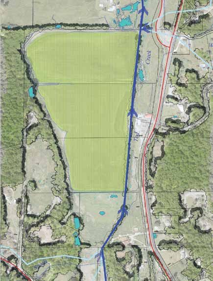
In its existing condition it is a poorly functioning Figure 1. Tod Creek watershed and Tod
ecological system that cannot sustain salmonid Flats study area
populations. The Tod Flat’s area (Figure 1) is one
such area that has been altered by land use change.
Group—has been formed to lead this community
The Tod Flat’s area is part of the flood plain of Tod process. The overall purpose of the project is:
Creek. The creek spills its banks in the fall, flooding
much of the land until June or early July. During this • to identify how the Tod Creek Flats
flooded state it becomes a major stopping place for area functions presently compared
local waterfowl. The problem is that the length of to historical observations;
time the fields are flooding seems to be increasing • to identify what the key problems/ interactions/
such that the growing season has been significantly management issues are within the system
reduced. In efforts to increase the growing season, as it relates to agriculture, wildlife habitat,
farmers are pumping water off the land each spring flood plain function and the health and
in the hopes of planting and harvesting crops. welfare of the local community; and
• to look at the site in a holistic manor and
The District of Saanich has received an Infrastructure develop a framework/ concept plan that
Planning Grant to develop a framework/ concept optimizes the use of the site for agriculture,
plan with the intention to integrate the various flood plain function and wildlife habitat values.
objectives for land use of the Tod Flats. A
working group—the Tod Creek Flats Working
District of Saanich
1
Tod Creek Flats Integrated Management Plan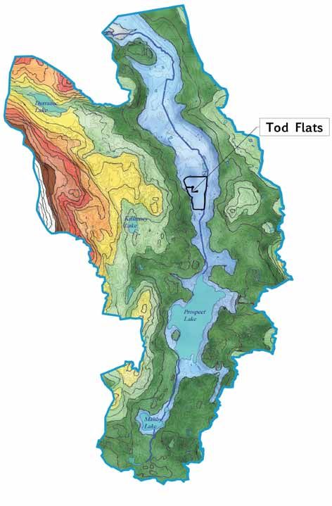
the issues
                                                            fish habitat. Impacts
 The Tod Flats site is an agricultural landscape            include loss of riparian
 that is encountering longer and more intensive             habitat, decreased
 flooding, resulting in shorter growing seasons. For        channel complexity,
 the lands owners and farmers, it is getting harder         low summer flows
 to farm the land and requires significant inputs           and higher summer
 to prepare the land for farming (i.e. flood water          water temperatures.
 pumping). The historic solution to this problem            On a positive note, the
 was to dredge the creek, lowering the water table,         seasonal flooding patterns of the flats provides
 to facilitate faster drainage. The following points        excellent waterfowl habitat in the fall, winter
 highlight that significant issues related to the flats:    and spring as well as create microhabitat
                                                            for two rare and endangered plant species

 Agriculture                                                (Callitriche marginata and Bidens amplissima).

    In its present condition,
    that land is becoming
    unfarmable. The duration
                                                           Economics                    Farming the Tod
                                                                                        Flats landscape
                                                            is becoming impractical from a business
    of flooding is increasing                               perspective. In order to ‘work’ the land in
    such that growing seasons                               the late spring ,the land must be drained
    are critically short resulting                          with mechanical pumps. Pumping is an
    in crop losses. Mitigation measures to pump the         unsustainable practice which is taking longer and
    fields dry in the late spring are becoming cost         is becoming more difficult
    prohibitive and impact sensitive habitat values         each year. In addition,
    associated with the landscape. Dredging the             the seasonal pumping
    channel is not considered an option since this          and cultivation of the land
    will further increase the rate of soil subsidence,      is causing subsidence of
    destroys stream habitat, and is not a sustainable       the organic soils which
    cure to the problem. The peat soils are less            further risks the long term
    than 30 cm deep in some areas of the flats.             viability of the farmland.

 Ecology
    reaches of Tod Creek
                         The
                         lower                             Social             Besides agriculture, the fields
                                                                              provide habitat for numerous
                                                            waterfowl in the fall and winter. Ducks,
    immediately upstream                                    geese and swans use the fields in the fall
    of the fish barrier, do                                 as a place to feed. Predatory birds prey on
    not support a significant                               these migratory populations which provide a
    fish population. There                                  winter food source for Bald Eagles. The new
    is potential cutthroat                                  bicycle and pedestrian path adjacent to the
    trout habitat between Prospect Lake and Tod             site facilitates easy access to the site and
    Flats. The remainder of the channel, including          the potential for this area as a destination for
    that which flows through Tod Flats, is very low         wildlife viewing. The flood plain/ farm fields also
    gradient (0.1 to 0.5%). The limiting factors to         provide a significant amount of runoff storage
    fish production are summer low flow conditions,         and act as a hydrological reservoir that buffers
    high summer water temperatures and low                  downstream fish habitat and built environments.
    dissolve oxygen levels. Past channel dredging
    and vegetation clearing of the
    stream/ditch negatively impacted

                                                                                     District of Saanich
                                                                                                            2
                               Tod Creek Flats Integrated Management Plan
the methodology landscape
                 evolution
The Tod Flats landscape land use presents a              The Tod Creek Flats landscape is a function of
complicated problem for property owners, the             geophysical attributes, glacial and post glacial
municipality and the steering committee. At issue        processes, hydrological processes and present
are agricultural and aesthetic values, economics,        day land use and alterations. Huntley and
fish and wildlife habitat, stormwater management,        Bowman (2000) provide a detailed account of
and First Nations use of the land. It is a complicated   how the lands in the Tod Creek watershed have
problem with linkages to land use, historical            evolved through the interpretation of geology,
land cover changes, drainage manipulation and            surficial soils, and lake sediment information.
soil management practices. Our goal is to:
                                                         The following figure (derived from Huntley and
     1. understand how the watershed                     Bowman) illustrates how the Tod Flats landscape
         and Tod Flats are functioning from              may have formed. Tod Flats is at a present day
         a hydrological perspective,                     relative sea level elevation of roughly 44 metres.
     2. review historical and present land               The areas was covered by 850 metres of ice during
         use practices as it pertains to the             the last glaciation period, roughly 16,000 years
         site processes and functions,                   ago. The glaciers carved the land and deposited a
     3. identify site opportunities                      layer of till over much of the land as they advanced.
         and constraints, and                            The till was a mix of sediment (fine silts to gravels
     4. develop framework plans that work with           and boulders) that was spread and compacted as
         and support site processes, provide             the glaciers advanced over the land. The extreme
         agricultural opportunities and enhance          weight of the glaciers resulted in the land subsiding
         and/ or restore natural systems and             or sinking. As the glaciers melted sea levels also
         associated wildlife and fish habitat.           increased. The net affect was a sea level that was
                                                         roughly 80 metres high than it is today. In other
In order to make sound and practical land use            words, the Tod Creek Flats landscape was covered
decisions about the Tod Creek Flats landscapes,          by over 30 metres of sea water. During the roughly
land managers and owners need to understand how          3000 years of sea water inundation, glaciomarine
the site functions. The first step is to understand      sediment was deposited in the Tod Creek valley
how this landscape has evolved into what it is today.    bottom. This sediment was comprised of fine
                                                         silt and clay particles which drapes much of the
                                                         land from sea level to the +/- 80 metre elevation
                                                         band. As the ocean levels dropped, the water over
                                                         the flats went from saltwater to brackish marine
                                                         to freshwater. The bedrock formation that is the
                                                         present day location of the old Butchart Garden’s
                                                         weir was and still is a significant elevation control
                                                         point in the stream channel. Once ocean levels
                                                         fell below this level, the Tod Creek Flats landscape
                                                         would have become a shallow freshwater lake
                                                         or large wetland (about 10,000 years ago).

                                                         The valley bottom from Durrance Road to Hartland
                                                         Avenue was probably a large shallow freshwater
                                                         wetland Any sediments that were eroded from

                                                                                       District of Saanich
                                                                                                             3
                               Tod Creek Flats Integrated Management Plan
Organic Soil Development
                                                                                          in the Tod Flats
                                                 16000 yBP
the channel between Prospect Lake and
the flats would have quickly dropped to the
bottom of the lake. The shallow water body
would have provided excellent growing
conditions for aquatic and semi-aquatic
plants which would thrive in this nutrient       Entire watershed covered by ice during last glaciation period
rich water. Organic matter in the form of
dead plant material settled to the bottom of     15000 yBP
the depression where it accumulated over
time. Since there is very little gradient in
the valley bottom, very little if any material
would be lost due to erosion. There was also
very little lost due to decomposition since
there would have been very little oxygen at      Marine clay deposition in bottom lands
the bottom of the lake/ wetland. As a result,
organic matter accumulated. For close to         12000 yBP
12,000 years, this system was built on inputs
of organic matter produced by wetland and
aquatic plants. The net result was that the
landscape changed from a shallow waterbody,
to a large wetland as more and more organic
material accumulated. The channel likely
                                                 Start of peat soils development
would have meandered across the flats and
been heavily influenced by beaver activity.
                                                 8000 yBP
The exact depth of peat is unknown but
we do know if varies from 0.3 to greater
than 1.2 metres (personal observations).

                                                 8000 years of marsh plants contributing to peat production. Mini-
                                                 mal loss of organic matter since valley bottom was flat

                                                 1860 (150 yBP)

                                                  Maximum accumulation of peat soils occurred prior to drainage of
                                                  wetlands, land clearing and intensive farming activity

                                                      (derived from Huntley and Bowman 2000)

                                                                                          District of Saanich
                                                                                                                     4
                               Tod Creek Flats Integrated Management Plan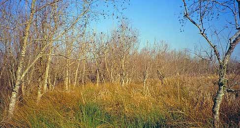
Historical
Drainage
Pattern
Historical survey information (Ralph, C.E. 1880)
clearly indicate that the present day Tod Flats
landscape was a marsh habitat dominated by
dogwood, willow, hardhack and (pacific) crab
apple. Prior to drainage modifications, the site
was probably dominated by a slow moving stream
with a strong meandering pattern. The forested
hillslopes would have slowed the delivery water to
the flats below. Water that seeped into the wetland
would have moved slowly through the organic soils
before reaching the stream. In summer months,
the peat soils would have yield cool water back
to the stream and sustained fish during summer
drought conditions. The thick vegetation cover
would have shaded the stream and helped maintain
cool water temperatures. It could have supported
salmonid species (rearing and adult) although
it would not have supported spawning habitat.
This would have been a deposition zone within
the watershed and accumulated sediment from
upslope areas as well as organic material produced
in the wetlands. The section below illustrates the              was below ground as interflow - not as surface or
thick organic soils that developed in this area and             channel flow. The means the system would have
the hydrological flow paths which supported the                 been very slow to flood, and also slow to drain.
landscape. The most significant aspect of the
site’s drainage pattern was that much of the flow

   water table
     interflow                                                                                           upland
                                                                                                         forest
                                       blue clay                    Wetland/ bog habitat
                               (glacio-marine clay)                 (hardhack, red osier dog-
                                                                    wood, willow, crab apple)
                                   organic
                                      soils                         seasonal wetland,
                                                                    open water bog

                                                                                   peat
                                                                clay
                                                                 glacial till
                                                      bedrock

                                                                                                      1850
                                                                                                District of Saanich
                                                                                                                      5
                               Tod Creek Flats Integrated Management Plan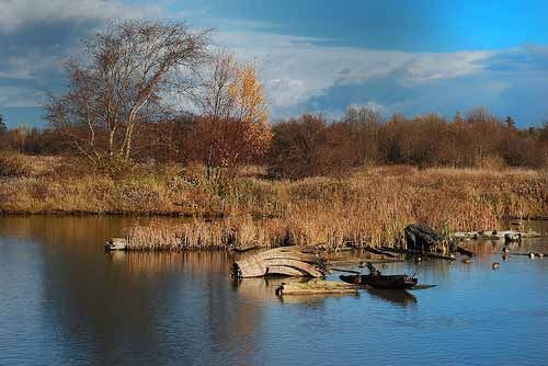
Prior to first contact, First Nations people were
water table Ditches inter- upland forest thought to use the lands as a source of food
Initial clearing and drain- cleared
interflow cept surface and (waterfowl and aquatic plants). European settlers
groundwater age result in significant excavated
land subsidence ditch arrived in the late 1850’s and immediately began
flow and divert it new to modify the landscape. Historical records from
around the flats (20-30 cm in first 5 years)
road
1874 indicate that ditching had already taken
original level
1850
place in the watershed. During the present study,
of organic soils surface a wetland drainage specialist indicated that the
flow
present day ditches that surround the flats were
intentionally designed to intercept water from
clay upland areas (Biebighauser, pers. com. 2009).
glacial till These ditches effectively cut off the water supply
bedrock
1880 to the wetland such that the land would be drier for
farming. The present day Tod Creek is basically
part of a large scale ditch system that functions
to convey stream water past the farm land as
well as intercept runoff from upland areas.
water table The initial ditching around the perimeter of the
Ditch cleaning cycle results in low-
interflow ering water table while agricultural site would have caused an immediate reduction
practices accelerate decomposition in the amount of water feeding the wetland.
original level and land subsidence Research indicates that this action would result
of organic soils in 20-30 cm of subsidence in the first 5 years.
ditch cleaning &
Current
deepening
Charcoal was found in soil samples taken at
the site. This could be evidence of aboriginal
clay
uses such as cooking pits or suggest that
the shrub land was cleared using fire (fires Drainage Patterns
bedrock
glacial till
could burned into the root system of existing
shrubs to become buried charcoal). & Soil Subsidence
1965 Once the land was drained and cleared, more
intensive agricultural practices could be initiated.
Organic soil levels reduced until clay When wetlands are drained and farmed, the
marine deposits are exposed organic soils that are present are decomposed. deposition zone in the watershed and accumulated
water table Decomposition results in the production of carbon organic material and sediment over time.
Subsidence and ditch cleaning further
interflow impact field drainage and result in ex- dioxide (CO2) and a lowering or subsidence Records indicate the ditches were cleaned ever
tended pooling throughout the grow- of the land. Studies indicate that sustained 30 years. They were often over excavated to
original level
of organic soils ing season agricultural practices on organic soils result in improve drainage capacity. This would result in
ditch cleaning &
annual subsidence rates of 1 to 3 cm per year the lowering of the water table, more oxidation
deepening (Schipper and McLeod, 2002, Thompson, 1980, of peat soils and continued subsidence.
Hutchinson, 1980). Over the past 150 years,
subsidence in the Tod Flats area could be between Peat depths were measured at various locations in
clay 1.5 to 4.5 metres! If conservative numbers were the flats. Depths varied from 30 to >120 cm. Based
glacial till used we would be still looking a very significant on conservative numbers, these findings combined
bedrock loss of soil and crop growing potential. with known subsidence rates, areas of the flats
2020? In addition, the ditches and creeks were historically
dredged or ‘cleaned’. The flats landscape is a
could be down to marine clay within 30 years.
Land Use Changes and Land Subsidence Process
District of Saanich
6
Tod Creek Flats Integrated Management Plan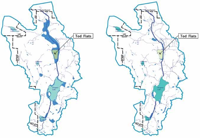
historical
                                                                                                        highlights
                        Present day conditions (ditching, land clearing,        Key historical findings are outlined below:
                        flooding, etc.) indicated that human activities have
                        modified the landscape. In order to assess how it has   the creek
                        been modified historical maps, reports and survey          • ditch probably dug after 1860’s land grants
                        information was reviewed. These maps provide               • 1874 surveyor identified various ditch crossings
                        much information and can show old channels and                by the property owner (Kratz’s Ditch, Crary’s
                        streams, provide clues to drainage patterns, and              Ditch, etc.) that is present day Tod Creek
                        indicate vegetation patterns from 150 years ago.
                                                                                the ditch
                        Early maps show a stream leaving Prospect Lake but         • ditch cleaning occurred in 1947
                        not connecting at Tod Inlet. That suggests incomplete          and 1979, a 30 year interval
                        mapping or possibly that the stream became a large         • discussions indicate that it is due to be clean
                        wetland that was not surveyed. In addition, early              again, roughly 30 years since last efforts
                        survey plans and notes indicate that the flats was
                        considered a marsh that supported wetland species.      the grades
                        Some of these maps area included here with the             • historical 1979 survey and plans
                        Tod Flats site indicated by the green shaded area.            illustrate existing and proposed
                                                                                      grades for ditch excavations
                                                                                   • similar data collected in 1947 but
                                                                                      it has since been destroyed
                                                                                   • present day replication of similar
                                                                                      survey indicates that material is
                                                                                      accumulating in the ditch.

                                                                                the flats
                                                                                   • Tod Flats and the ‘Tod Creek’ lowland
                                                                                       were a significant wetland/ marsh in the
                                                                                       watershed that probably started downstream

  1880                                                                                 of present day Hartland Road and
                                                                                       continued to present day Durrance Road
                                                                                   •		1874 surveyor identified vegetation as ‘crab,
                                                                                       hardhack, willow, and dogwood-very thick’
                                                                                   • 1880 surveyor identified the Tod
                                                                                       Flats area as a willow swamp

    historical
mapping review
                 1921

                                          present
                                                                                                              District of Saanich
                                                                                                                                    7
                                                       Tod Creek Flats Integrated Management Plan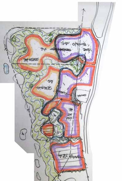
watershed
                                                             analysis
                                                             Tod Creek flows from south to north and discharges
                                                             into Tod Inlet. The diverse watershed comprises flat
                                                             seasonally flooded valley bottom with shallow lakes,
                                                             gently rolling landscapes to the east and steeply
                                                             sloping hills to the west. Tod Creek is confined to
                                                             a ditch from just below Hartland Road to Durrance
                                                             Road. The creek is more or less flat in this zone
                                                             with a gradient of 01. to 0.5%. The last 400 to
                                                             500 metres are more steeply sloped as the creek
                  Tod Flats                  Tod Flats       drops into Tod inlet. The contour banding map
                                                             graphically illustrates the watershed topography.

                                                             The watershed was divided up into sub-drainage
                                                             units to assess potential drainage problems
                                                             related to the flats. The flats is located in the
                                                             valley bottom and has two main water input
                                                             sources. The first is the upstream discharge
                                                             from Tod Creek. The second is water from the
                                                             surrounding landscape and valley walls.

                                                             The watershed area that contributes water to the
                                                             Tod Creek Flats landscape is roughly 15.3 square
                                                             kilometres. Not all of the rain that falls in this area
                                                             will make it to Tod Flats however. Rain water is
                                                             intercept by plant leaves and evaporated, taken
                                                             up by plant material and evapotransporated, or
                                                             stored in aquifers. The remaining water will travel
                                                             via interflow (water movement through the soil),
                                                             overland, and channel flow to the Tod Flats area.

                                                             Prospect Lake is a significant hydrological buffer
                                                             for the Tod Flats landscape. Its combine sub-
                                                             drainages represent 68% of the Tod Flats catchment
                                                             area. The remaining 32% of the drainage area
                                                             will probably have more potential to affect the
                                                             flats given that there is not significant buffering
                                                             between these drainages and the flats.

contour
plan
        banding               sub drainage
                              areas

                                                                                             District of Saanich
                                                                                                                       8
                                               Tod Creek Flats Integrated Management Plan
land use analysis
& implications
agricultural
land reserve
Development in the watershed has altered the land
cover and hydrology of the watershed. Presently,
land cover consists of forested lands, lakes and Tod Flats
wetlands, small to mid-sized agriculture operations,
hobby farms, rural residential, industrial uses
in the form of the Hartland Landfill in the upper
reaches of Durrance Creek and small commercial
areas. Historic land clearing, draining of wetlands,
road construction, tilling of fields and development
and its associated infrastructure has impacted
the hydrologic performance of the watershed and
negatively impacted fish habitat. These impacts commercial
include increased stream temperatures, decreased rural large lot
single family (some
oxygen levels, loss of riparian cover, increased
smaller lots around
sediment levels, and overall reduced water quality. Prospect Lake
To assess potential impacts from land use changes
we analyzed impervious area (built areas that
produce stormwater runoff), channel density (amount
of channel/ pipes per unit area) and wetland areas park/ open
space
at the watershed. Pre-development land conditions
were compared to existing conditions for these three
variables. The purpose of this exercise was to help
determine whether land use change was having a
major impact on stream health and flooding in the
flats study site and to identify the problem(s). land use
This study did not measure impervious surfaces but
impacts are typically noted when effective impervious
impervious cover data from the CRD (Natural Areas
area is greater than 10% in a watershed or sub-
Atlas mapping, 2009) does show impervious areas
basin area. That level has not been reached in
(roads and buildings). Given the nature of urban
the Tod Creek watershed. From a development
development, most runoff from the roads is conveyed
perspective, care should be taken with regard to
by ditches to the nearest stream. Although damaging,
future development within the non-basin drainage
urban development remains scattered throughout the
areas that contribute to the flats along with the Ward
watershed and tends to be large lot, rural hobby farms
and Wray sub-basins areas that feed the stream
with relatively low density and low effective impact
adjacent to the flats. Low Impact Development (LID)
area. These tend to have simple drainage systems
planning and design practices should be applied
that often spill onto the land rather than be connected
in these areas and elsewhere in the watershed.
to large piped infrastructure systems. In simple
Drainage practices that disconnect impervious areas
terms they, are disconnected from the downstream
from streams and ditches should be encouraged.
receiving waters and therefore do not contribute much
in the way of stormwater to the system. Hydrological
District of Saanich
9
Tod Creek Flats Integrated Management Planimpervious
area
predevelopment postdevelopment
streams &
channels
predevelopment postdevelopment
channel density 2.9 channel density 4.5
District of Saanich
Tod Creek Flats Integrated Management Plan 10wetland
85%
lake
reduction
in wetlands
wetlands
predevelopment postdevelopment
Stream flows through Tod Flats are highly
dependant on the control of water exiting the At the watershed scale, the most significant
dam at Prospect Lake. Care must be taken change is the loss of wetland habitat. It is
with the operation of this outlet dam to ensure estimated that 85% of the wetlands have been
winter flows are retained but more importantly, drained or modified over the last 150 years.
that summer base flows are sustained. This loss would account for a significant loss
of hydrological buffering in the watershed.
The lakes and wetlands within the watershed
perform a significant buffering affect on hydrological
changes due to development. This is not to say that
development won’t alter stream hydrology, rather that
the lakes and wetlands will help to moderate peak
flows and release water more slowly to downstream
receiving areas. Typically in this part of Vancouver
Island, winter rains fill the lakes, wetlands and
soils which then slowly release that water back
to the stream during the dry summer months.
District of Saanich
Tod Creek Flats Integrated Management Plan 11impervious area
• some increase mostly due to
roads and buildings
• not a significant impact to Tod Flats hydrology
channel density
• roughly 1.5 fold increase in channel density
• relatively small amount compared to
urban watersheds which often have 25
to 30 fold increase in channel density
wetlands
• ditching and conversion of marsh to agricultural
lands is probably the most significant factor
affecting the watershed and the Tod Flats area
• watershed has seen roughly 85% of its
wetlands disappear in the last 150 years.
• the watershed has lost a significant
hydrological buffer
land use
• land use changes have significantly altered the
landscape and how it performs and functions
• ditching and vegetation removal
have had a significant negative
impact on watershed hydrology
• loss of forest cover was probably more
significant in the late 1880’s after much
of the land and forests were cleared.
• historical ditching and land drainage
have resulted in greater flow
fluctuations and negatively impacted
summer low flow conditions
District of Saanich
Tod Creek Flats Integrated Management Plan 12Hedge Row
Habitat
Spring waterfowl Very low gradient
nesting areas and channel (0.1 to 0.5%)
shorebird habitat Fall and Winter research indicates
Waterfowl Habitat this should support
Seepage area with meander pattern, not
Western Red Cedar straight channel form
and Cottonwood
stand Channel has been
dredged serval times.
Callitriche margi-
Bottom of ditch below
nata (winged water
peat levels.
starwort)
Moderate riparian
cover-no large
riparian trees
Second growth
Douglas fir stands Poor instream habitat
condition due to
Bidens amplissima elevated summer
(Vancouver Island water temperatures
Beggarticks) caused by low flows.
Channel passable
to salmonids during
higher flow events.
Vegetation buffers
flats from potential
upslope impacts
Wildlife Habitat is considered S3 (Vulnerable) and Blue-listed. The
winged-wart starwort (Callitriche marginata) normally
occur in coastal bluff vernal pools but were recently
Tod Flats supports a variety of unique habitat types found (since 2007) at Tod creek flats (Costanzo et.al.
ranging from seasonally flooded fields to hedge row 2009). This species appears to do well under the
thickets. Fish habitat in Tod Creek is poor due to farming regime of 2007 and 2008 where the water
water quality issues and poor habitat characteristics. was pumped for ploughing and planting in mid June.
The north and east edges of the flats support good Migratory birds use the flooded fields for food and
hedge row and upland forest transition zones many species nest along the dugout area in the
respectively. Of interest are populations of Winged middle of the flats. Bald Eagles also frequent the
Water Starwort and Vancouver Island Beggarticks. area in the winter, preying on the abundant waterfowl.
Currently Callitriche marginata is not protected under
any BC or federal laws, however, it is considered
S1 (Critically imperilled) and Red-listed by the
Conservation Data Centre (CDC). Bidens amplissima
District of Saanich
Tod Creek Flats Integrated Management Plan 13Shallow water
inundation
Shallow Peat Soil
Depth
Developable Land (housing
Springs
where zoned, education centre,
interpretive centre, etc.,)
Deep-prolonged
inundation
Shady due to
topo. and aspect
Interceptor ditches
direct surface and
groundwater flow
around flats
Springs
Opportunities and
Constraints Plan
The flooding patterns, topography, soil type and groundwater and divert it around flats
wildlife species present many site planning and • Peat soils less than 30 cm deep in certain zones
design opportunities and constraints. These
have been outlined in the graphic above.
Site Constraints Site Opportunities
• Fields flooded mid-October to mid to late July • East side of properties have excellent access to
• West side of field shaded by steep hillslope West Saanich Road and Bicycle/ Pedestrian path
• Saanich flood plain mapping states all • East side of fields is sunny-less impacted
development to occur at elevations greater by steep western hillslopes.
than 46.88 m geodetic elevation • Good forested and hedgerow habitat on
• Flood waters trapped in ‘bowl’ west and north sides respectively
extends inundation period • Peat soils >1 m deep on west side of fields
• Springs/ seeps along west bank of flats • Commercial node (Red Barn Market)
• Landscape depressions result in attracts people to the site
extended duration of inundation.
• Ditches intercept cool
District of Saanich
Tod Creek Flats Integrated Management Plan 14Framework Plan
and Charrette Designs
The goal of the project was to look at the site
in a holistic manor and develop a framework/
concept plan that optimizes the use of the site for
agriculture, flood plain function and wildlife habitat
values. On June 30, 2008, a group including
land owners, a wetland specialists, landscape
architects, a stream biologists, a soil scientist and
municipal staff conducted a one day planning
and design charrette. Landscape architects
from MDI along with Tom Biebighauser (wetland
specialist) guided the 1-day planning and design
charrette. The day will be broken into a morning
site review and education session and an afternoon
planning and design charrette. The morning
session included a field review and discussions
about the current status of the land and possible
options for future work on the land. Discussions
centred around how the site functioned and the
identification of sites opportunities and constraints.
In the afternoon, the group was divided into two
design teams guided by the design staff of MDI. The
goal was to develop Framework Design Options
for the Tod Flats landscape. Two framework plans
were developed that took into consideration site
opportunities and constraints. The framework options
were used to test various program elements including:
• enhancing agriculture productivity,
• maintaining/ enhancing flood plain capacity,
• enhancing wildlife and fish habitat values,
• providing wildlife viewing opportunities,
• identifying an irrigation supply source, and
• managing pollution loads from
West Saanich Road runoff.
The two framework plans that were developed
are illustrated on the following pages.
District of Saanich
Tod Creek Flats Integrated Management Plan 15Seasonally
flooded
Berry Crop
-salmon berry,
blueberries etc.;
hops
Restored Rarely flooded
stream channel Wetland/
with increased constructed
sinuosity pond ( water
source for
irrigation ?)
Seasonally
Wetland area flooded area
adjacent -100 day growing
to stream season
channel, -native grass for
seasonally hay?
flooded
-Marsh trees &
shrubs
Difficult
to service
and install
mechanically
ideas....
duck potato
christmas trees
lavender
flowers
mudflats
Concept One
High Lights Pros and Cons
• Restore stream to middle of Tod Flats, • Moving stream to middle of valley bottom
• Restore channel, creek flood plain consumes the most land and signficantly
and riparian habitat zones, reduces the amount of seasonally flooded field,
• Maximize grades above 45.38 m • Small ‘pocket’ fields are difficult to
geodetic for agriculture-organic farm farm (too small to be practical),
plots outside of flooded areas, • Moving intensive agriculture activity to east
• maintain flood plain requirements, side moves all production to the sunny side
as per Saanich bylaw. of site and closer to roads/infrastructure,
• Utilize abandoned ditch for possible irrigation
ponds or stormwater management facilities.
District of Saanich
Tod Creek Flats Integrated Management Plan 16Seasonal
Agriculture
-seasonally
flooded
Year-round
Agriculture
Restored Existing
stream channel market
Rain garden
with adjacent
wetland area
, seasonally
Year-round
flooded
Agriculture
- High
intensity
Concept Two
High Lights Pros and Cons
• Restore stream moved to east side of Flats, • Patches of seasonally flooded
• Restores channel, creek flood land impractical to farm.
plain and riparian habitat, • Diverse channel forms maximize habitat diversity
• Maximize grades above 45.38 m but reduce size of seasonally flooded fields.
geodetic for agriculture-organic farm • Moving stream to eastern edge of field
plots outside of flooded areas, minimizes the amount of land consumed,
• maintain flood plain requirements places stream in shadow of hillslope
as per Saanich bylaw, (cooler habitat) and links stream to cool
• provides high diversity of habitat types groundwater fed springs on east side.
including seasonal wetlands, edge • Moving intensive agriculture activity to east
habitat and forested hummocks. (sunny ) side moves intensive activity areas
closer to infrastructure (roads/ access)
• Rain gardens manage pollutants
from W. Saanich Road.
District of Saanich
Tod Creek Flats Integrated Management Plan 17framework plan
option 1
Program Elements
• 15 to 30 m wide stream with
flood plain on east side
• Excavated material moved to west side
to increase land height to 45.38 m (above
max. recorded water elevations).
• Create mudflats habitat and seasonally
flooded field areas suitable for Callitriche
marginata (winged water starwort) and Bidens
amplissima (Vancouver Island Beggarticks).
• Mudflats inundated from early fall to late July
• Seasonally flooded fields inundated
November to May.
• Mudflats inundated from early fall to late July.
• Irrigation ponds developed for each property.
• Stormwater from West Saanich Road
diverted into vegetated swales and rain
gardens developed in abandoned Tod Creek
ditch. Swales to follow existing property
lines. This will act to clean runoff but also to
separate agricultural crops for road runoff.
• Seeps and springs from western
slope tied into new channel
Design Critic
• See Habitat Analysis Fact Sheet
Chart for habitat created
• Mud flats will provide unique habitat presently
lacking in CRD for migratory birds.
• Over 1.4 km of functional stream habitat
• Create 6 ha of functional riparian habitat
• Create 6-7 ha of aerable farm land
fill material from on site
Note: Cut/fill to be
placed such that flood
plain capacity is not
reduced.
excavated or ‘cut’ material
District of Saanich
18
Tod Creek Flats Integrated Management Planframework plan
option 2
Program Elements
The program elements are the same as
option 1 with the following exceptions:
• Large permanent wetlands will be created
within the riparian area of the stream.
These would be deep, water bodies that
would remain wetted year-round.
• Mudflat habitat would be limited to
the margins of the seasonally wetted
fields (as is presently the case)
Design Critic
• Similar habitat benefits to option 1
• Large wetlands would create additional
habitat diversity for fish and waterfowl
• Large wetlands would be a significant aesthetic
feature and provide year round water views
for visitors and residents of the area
• Permanent wetlands/ irrigation ponds could
support populations of invasive bullfrogs (life
cycle requires 2 years of standing water)
• Reduced mudflat habitat to margins
of seasonally wetted fields
fill material from on site
Note: Cut/fill to be
placed such that flood
plain capacity is not
reduced.
excavated or ‘cut’ material
District of Saanich
19
Tod Creek Flats Integrated Management Planhabitat fact sheet
The comparison table below indicates the lack of permanent, high quality habitat presently in the Tod Flats
landscape. The area seasonally supports large populations of waterfowl but the stream and riparian habitat
are in very poor condition. In addition, seasonal changes to the land (draining, tilling, planting, etc.) negatively
affect the existing rare species plant communities. The proposed plan increase the amount and quality
of stream, riparian, and mudflat habitat. In the proposed plan, these become permanent habitat types.
Habitat and land cover comparison of existing and the proposed plans for Tod Flats
Existing Proposed
High Quality Stream Habitat 0m 1400 m
Seasonally Flooded Fields 17.1 ha 4.5 ha
Non-Flooded Fields 0 ha 7.1 ha
Irrigation Ponds and assoc. Riparian Edge 0.4 ha 1.9 ha
Scrub Brush 6.8 ha 1.0 ha
High Quality Riparian/ Wetland Habitat 0 ha1 6.8 ha
Mud Flat (option 1) Wetland Ponds (option 2) 0 ha2 3.0 ha
Hedgerow/Forest Edge Habitat 0.9 ha 0.9 ha
Total 25.2 ha 25.2 ha
1 The existing Tod Creek does support riparian habitat but it is in poor functional condition and has
therefore not been included. In addition there is no stream floodplain associated with the ditch. The
channel is confined to the ditch.
2 The seasonally flooded fields presently support two rare plant species and do function as mudflats.
However, in any given year these areas could be cultivated and planted such that they do not provide
year round mud flat habitat.
District of Saanich
Tod Creek Flats Integrated Management Plan 20agriculture fact sheet
Much of Tod Flats is farmed using industrial agricultural practices, which requires large inputs
of energy and large machinery to cultivate, plant and harvest the field. It has been farmed as
one large field rather than as individual fields. This type of farming is based on large inputs of
energy and equipment and contributes to green house gas production. The land is approaching
a time when areas of it will be unsustainable to continue farming. Continued subsidence will
result in prolonged flooding, shorter growing seasons, and the exposure of clay sub-soils.
The proposed plan would see the land better managed to fit the natural conditions of the site. The creation
of a stable land base above the 45.38 m high water elevation would create opportunities to develop organic
farm plots. Organic farming is intensive in terms of people inputs not chemical or petroleum inputs. In
can be managed as a significant sink for green house gases. Both proposed options retain some of the
seasonally flood fields that could still be used for production of potatoes, which has been the crop of choice
on this land. These options also present the agriculture industry with a significant opportunity to educate the
population about organic farming, integrated farm management plans, water resources, and natural systems.
Agricultural comparison of existing uses and the Option 1 proposed plan
for Tod Flats
Existing Proposed
Agriculture Type Large Scale Industrial Organic Intensive
Seasonally Flooded Fields 17.1 ha 4.5 ha
Non-Flooded Fields 0 ha 7.1 ha
Rate of return per ha low to mod. very high
Production Cost per ha high (mechanical) mod.-high (labour)
Very High Very Low
Greenhouse Gas Production
(carbon source) (carbon sink)
Education Opportunities low high
District of Saanich
Tod Creek Flats Integrated Management Plan 21information gaps
The following items outline missing information that • Review options to expand the study site to
need to be gathered, or areas of study that need to include the entire valley bottom to north of Dur-
be addressed: rance Road. The implications are that the entire
system has been modified, and future flooding
• Site survey information to pick up missing of areas downstream of the flats will continue
ditches on west and north side of flats since these lands were derived in much the
same way. They presently rely on ditch clean-
• Ground water levels during the course of the ing and water table lower to maintain flow and
year for site specific locations. Simple soil drainage.
sampling devices could be used periodically in
the summer to determine summer groundwater • Review Prospect Lake dam flow control opera-
level. tions to ensure summer base-flow levels are
met.
• Complete peat depth surveys (presently on third
of the site has been surveyed). This information
combined with site topography could be used to
better locate ponds.
• Review soil information and determine best way
to build soil depth. For example should peat
soils be excavated and used to build soil height
(to 45.38 m elev..), should clays be used or
some combination of these materials.
• Funding opportunities for detail designs, imple-
mentation planning, and construction.
• Crop suitability analysis of seasonally flooded
landscape.
• Review design options that will discourage nui-
sance wildlife such as Canada Geese.
• Alternative means to replenish/ build peat soils
(add compost from large scale composting pro-
grams, re-flooding the land and growing specific
crops that would add peat production, etc.
District of Saanich
Tod Creek Flats Integrated Management Plan 22conclusions
The Tod Flats landscape was historically a source of tat as an aside, the future plans take a holistic view
food for local aboriginal populations. In the past 150 where agriculture, wildlife habitat, aesthetic and social
years the land supported more intensive agricultural values and flood control all have equal weight. The
uses ranging from local market gardens to industrial designs work with and restore the natural systems of
potatoe farming. Modern farming practices have site rather than over ride them. The plans illustrate a
required that water be drained from the site in order vision for the Tod Flats landscape that best approxi-
to work the land. The single, most important issue mate a sustainable landscape for the future.
pertaining to the agricultural use of this site is water
management.
The Tod Flats landscape was created by a combina-
tion of geological processes, organic accumulation
over time and the modification of the land cover and
drainage practices by modern civilization. It is a
landscape that was built by inputs of organic material
over a 12,000 year period. Water played a key role in
the site as the slow movement of water resulted in the
accumulation of organic matter (peat) which did not
decompose due to the high water table.
Drainage and agricultural practices of the day lead
to draining of the land and the implementaiton of
intensive agricultural practices. In the 1860’s food
production was of major importance. Issues related
to fish habitat were not. For 150 years drainage and
agricultural practices have had a significant affect on
the condition of the flats and how it functions. What
was historically a system built on inputs (water/organ-
ics) was instantly converted to a system or removals
(water/carbon/crops). A thick organic soil which was
built over a period of 12,000 years has been depleted
by 150 years of land use change and drainage ma-
nipulation.
The plans presented in this report are not detailed
plans, rather they are working concepts based on
our knowledge of the site, historical records, and the
desire of the present land owners to work with the
land and do something positive. Rather than being a
landscape dominated by agriculture with wildlife habi-
District of Saanich
Tod Creek Flats Integrated Management Plan 23references
Biebighauser, T. 2009. pers.comm. Wildlife Thompson K. 1980. Peat and peatlands:
Biologist. Center for Wetlands and Stream economic and scientific importance. In: Soil
Restoration. US Forest Service, South Groups of New Zealand. Part 4: Organic
Morehead, KY Soils, eds F.C.C. Hupkens van der Elst &
D.I. Kinloch, New Zealand Society of Soil
Capital Regional District, 2009. Natural Areas Science Government Printer Wellington 17-
Atlas. web site http://www.crd.bc.ca/maps/ 25.
natural/atlas.htm
Costanzo, B., J. Penny, and C. Junck. 2009.
Callitriche marginata and Bidens amplissima
at Tod Creek Flats Considerations for Spe-
cies protection, Management, and Translo-
cation.
Huntley, D. and C. Bowman. 2000. Overview
of bedrock and surficial geology, lake cores
and palaeoenvironmental history of the Tod
Creek watershed, S.E. Vancouver Island.
Hutchinson J.N. 1980. The record of peat
wastage in the East Anglian Fenlands at
Holme Post, 1848-1978 A.D. Journal of
Ecology, 68, 229-249.
Ralph, W. 1880. Survey in Lake District, Van-
couver Island, BC. Survey of Sections 84,
86, 87 and 88. Field Book 26/1880 PH001
located at Surveyor General & Crown Land
Registry, Victoria, BC
Schipper L.A., and M. McLeod. 2002. Subsid-
ence rates and carbon loss in peat soils fol-
lowing conversion to pasture in the Waikato
region, New Zealand. Soil Use and Manage-
ment, 18, 91-93.
District of Saanich
Tod Creek Flats Integrated Management Plan 24District of Saanich Tod Creek Flats Integrated Management Plan
You can also read