The Southwest Tasmania Fires of Summer 2018-2019 - Zurich
←
→
Page content transcription
If your browser does not render page correctly, please read the page content below
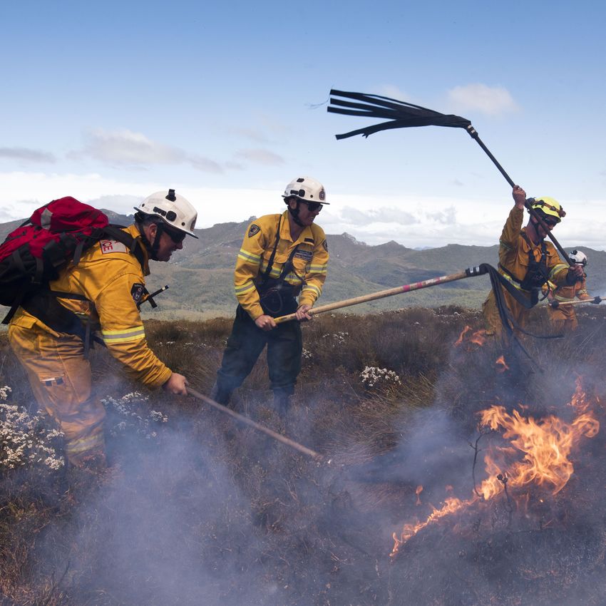
The Southwest Tasmania
Fires of Summer 2018-2019
A Post Event Review Capability Study
Dr Adriana Keating and Prof John Handmer

Firefighters using fire beaters to
fight the Gell River fire in the Tasmanian
Wilderness World Heritage Area. Credit:
Warren Frey, AFAC, supplied.
Table of Contents

                                           Foreword: Tim Plant.........................................................................................................................................................................                    2
                                           Foreword: Richard Thornton......................................................................................................................................................                                3
                                           Executive Summary and Recommendations.................................................................................................................                                                          4
                                           Introduction............................................................................................................................................................................................        7
                                           Section I: Physical Context.........................................................................................................................................................                            9
                                               Previous Bushfires in Tasmania........................................................................................................................................                                      9
                                               Landscape......................................................................................................................................................................................             11
                                               Climatic conditions....................................................................................................................................................................                    14
                                           Section II: Socio-Economic Disaster Risk Management Landscape...........................................................                                                                                       16
                                               Institutional arrangements....................................................................................................................................................                             16
                                               Exposure and vulnerability...................................................................................................................................................                              18
                                               Prospective risk reduction....................................................................................................................................................                             20
                                               Corrective risk reduction: prescribed burning.........................................................................................................                                                     20
                                               Preparedness................................................................................................................................................................................               24
                                           Section III: What Happened.......................................................................................................................................................                              27
                                               Bushfire ignition...........................................................................................................................................................................               27
                                               The Fires and Firefighting Operations..........................................................................................................................                                            28
                                               Community Safety Response.............................................................................................................................................                                      31
                                           Section IV: Impacts and Recovery........................................................................................................................................                                       36
                                               Direct impacts...............................................................................................................................................................................              36
                                               Indirect impacts...........................................................................................................................................................................                40
                                               Recovery..........................................................................................................................................................................................         43
                                           Section V: Key Insights..................................................................................................................................................................                      47
                                               A New Fire Regime in Tasmania.......................................................................................................................................                                       47
                                               Before the disaster strikes....................................................................................................................................................                            49
                                               During the disaster....................................................................................................................................................................                    50
                                               Response and recovery operations...............................................................................................................................                                             51
                                               The role of research and science.....................................................................................................................................                                      53
                                           Section VI: Recommendations.................................................................................................................................................                                   54
                                               Risk reduction and preparedness...................................................................................................................................                                         54
                                               Emergency response...............................................................................................................................................................                          55
                                               Community response and recovery...............................................................................................................................                                             55
                                           References..............................................................................................................................................................................................       57
                                           Glossary....................................................................................................................................................................................................   60
                                           Interviewees...........................................................................................................................................................................................         61
                                           Acknowledgements.........................................................................................................................................................................                      62
ZU24174 - V1 03/21 - IMOI-016606-2021

                                                                                                                                                                                                                                                                Page 1 of 62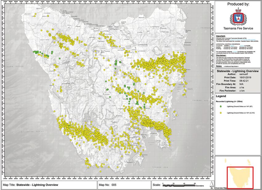
Foreword: Tim Plant

                                                                  Core of my heart, my country! Land of the rainbow gold,
                                                                 For flood and fire and famine, she pays us back threefold.
                                                                                          Dorothea Mackellar: “My Country”

Weather events are natural, but disasters are not.
Bushfires are a natural part of the Australian summer landscape but pose a real threat to property and lives. We don’t
have to cast our minds too far back to remember the devastating bushfire season during the summer of 2019-2020.
The impact and pain from that bushfire season is still being endured by many Australians 12-months on.
In addition to the direct impact, we are beginning to realise the indirect and long-term impact bushfires have on
industries and livelihoods – including the tourism, agriculture and viticulture industry, just to name a few. As green
shoots begin to appear in our land, it is often the societal and financial impacts that endure within the community.
What’s more, the Australian bushfire season is increasing in duration and severity in some regions. Traditionally cool
climate areas of Australia are beginning to experience bushfires of a treacherous nature for the first time. Longer
bushfires seasons have also left authorities with limited time outside of the bushfire season to practice good land
management and bushfire prevention strategies.
Insurance is an important aspect of financial recovery following disaster, but there are other ways in which risk can be
mitigated. Preparation and planning are key to prevention, and this is at its most successful when there is harmonic
rhythm and collaboration between government, community, small business, and the insurance and financial sector.
With the above in mind, Zurich Insurance has officially launched a Post-Event Review Capability (PERC) in response
to the 2018-2019 Tasmanian Bushfires. This PERC has been formed based on research, endorsement and review from
a range of internal and external experts.
Originally developed by the Zurich Flood Resilience Alliance, Zurich’s PERCs are a systematic framework for analysing
disaster events, including understanding how a hazard became a disaster, and identifying where and how resilience
can be built. A PERC does not recommend specific interventions, rather, it identifies critical gaps and actionable
opportunities to reduce risk and build resilience. This includes a particular focus on specific local stakeholders who
can then design and implement interventions grounded in the local context.
Zurich PERCs have traditionally focused on floods and storms. However, given the significant impact recent bushfires
have had on Australian communities and industries, Zurich has turned its attention to the topic of bushfires for this
latest PERC.
We have embraced much of what is highlighted above to create a truly unique PERC, focusing on a natural hazard that
we are beginning to see occur with increasing severity and frequency in an area not usually associated with this type
of event.
I am proud to contribute the foreword to this PERC, and I hope that it will help us all reflect on how we can better plan
and prepare for future disasters as a nation, community and industry.

Tim Plant
Chief Executive, General Insurance (Australia & New Zealand)
Head of Commercial Insurance (Australia & New Zealand)
Zurich Financial Services Australia

Page 2 of 62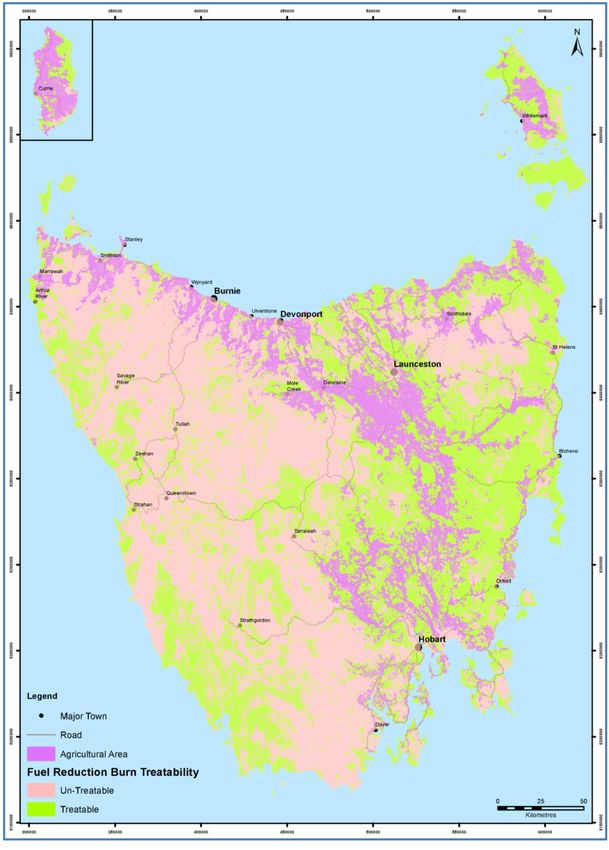
Foreword: Richard Thornton

This report highlights the importance of understanding all aspects of the impacts from natural hazard events. In this
case a series of Bushfires (Wildfires) in south-western Tasmania in 2018-19.
Most analyses of events take a narrow view looking at specific aspects, such as response or preparedness or impact.
This report highlights the power of the Zurich Flood Resilience Alliance’s Post Event Review Capability (PERC)
methodology in providing a more wholistic view of the events. It also highlights how the principles of the PERC
methodology can be applied to the Bushfire context.
The methodology applies a resilience lens to the topic of evaluation, in particular it focuses on community and business
resilience. In doing this it considers what risk reduction and preparedness measures had been implemented prior to the
events. It goes on to consider the community response and then community and business recovery.
Importantly, the study identifies opportunities to further develop the resilience of Tasmanian communities, as well as
extrapolates to where these opportunities can be applied more widely in Australia and globally.
In a time where there is a rising risk across most of Australia, and globally, as the result of climate change and
demographic and societal shifts, it is vitally important that we can examine past events to help to learn lessons that help
to mitigate the impacts of the increasing severity and frequency of natural hazards.
It is important that these risks are considered from a multifaceted viewpoint, as single siloed solutions are not going to
see the reductions in exposure and vulnerability needed. This will require a whole of community approach and using
methodologies such as PERC can help to better achieve the required learnings.
The Authors have done an exceptional job of bringing together the views of community members, business owners and
government officials to craft meaningful conclusions and recommendations. I would recommend this report to anyone
who has an interest in better understanding the diverse interplay between different sectors of the community in the lead
up to, during and after a major event.

Richard Thornton
Chief Executive Officer, Bushfire and Natural Hazards Cooperative Research Centre

                                                                                                                   Page 3 of 62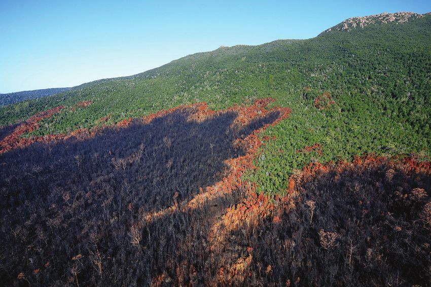
Executive Summary and Recommendations

The summer of 2018-19 (December 2018 – February 2019) was devastating for the Australian state of Tasmania. Fire
services were overwhelmed by the multiple, large fires that burned over 200,000 ha across the western half of the island
from the end of December through to early March. This report analyses these fires using the Zurich Flood Resilience
Alliance’s Post Event Review Capability (PERC) methodology. It focuses on community and business resilience; while
there have been several reviews into firefighting operations, a more systemic view of resilience is less common.
The summer 2018/19 fires officially began on 24 December 2018, in one of the hottest and driest summers on record.
On 15 January 2019, 2402 dry lightning strikes hit the state, igniting 70 fires that formed into four massive fire complexes.
More than 210,000 hectares burned, including 95,000 hectares in the Tasmanian Wilderness World Heritage Area
(TWWHA). Fortunately, no deaths were directly attributed to the bushfire, although an unknown number of people are
believed to have died due to smoke and 114 injuries or accidents were recorded.
The event saw a significant and protracted evacuation, with the Huonville evacuation centre open for 15 days,
accommodating up to 700 people daily. The lingering effects on impacted communities are still being felt. It resulted in
the destruction of tourism assets, forestry resource and globally precious, protected ecosystems of the TWWHA. Smoke
from the fires impacted health and the burgeoning viticulture industry in Tasmania. These impacts, along with others,
have had significant flow-on effects to the already-struggling Tasmanian economy and communities.
There is much to learn from this event for Tasmania and other jurisdictions which will likely face similar events. This report
outlines the risk landscape in southwest Tasmania, examining trends in climate-change charged bushfire conditions,
exposure of people and assets, and their vulnerabilities. It outlines what happened during the event, with a focus on
the community safety response. Direct and indirect impacts on people and economies are explored. Key insights are
identified across all phases of the disaster cycle. Below we present an abridged version of the final recommendations
of the study.

Risk Reduction and preparedness
Support for PWS as it develops a bushfire management plan for the TWWHA.
The first need identified by this review was a multi-stakeholder process for the development of an adaptive bushfire
risk management plan for the TWWHA. Since the event, PWS has initiate the development of a fire management plan.
We find that across the board there is a strong desire to work collaboratively to preserve the TWWHA, which provides
a robust foundation for multi-stakeholder dialogue. While the details of PWS’s plan have not been released yet,
ideally it would ultimately encompass a holistic risk management approach that includes all steps of the disaster risk
management cycle.

Slow the growth in bushfire risk via land-use and building regulations.
Increasing bushfire risk in Tasmania could be mediated by more action to prevent further build-up of assets in high risk
areas. Tasmanians would benefit from investment in high quality modelling of current and future bushfire risk to update
the bushfire-prone overlays and roll them out across the state.

Implement a risk reduction plan that complements risk-based prescribed burning with other strategies.
Further investigation into the options for prescribed burning in wilderness areas, including the TWWHA, is needed.
Increasing risk means that, like all Australian states, Tasmania would be well served by complementing its prescribed
burning program with other hazard management strategies, such as fuel breaks, particularly to protect townships and
other important assets and infrastructure.

Support strong working relationships between fire agencies, land owners and conservationists.
There is considerable mutual respect and alignment in perspectives between fire agencies, landowners and
conservationists in Tasmania. We recommend that these strong working relationships be reinforced, and potentially
formally codified, to support further movement towards a comprehensive and adaptive bushfire risk management
scheme in Tasmania.

Page 4 of 62
Expand community engagement in bushfire resilience and preparedness programs.
The Bushfire Ready Neighbourhoods Program run by TFS is based on best practice for community resilience and
preparedness programs, and is delivering positive results. Key factors in the success of this program include support
from TFS leadership, a foundation based on long-term community development principles and engagement with
local researchers.

Climate change adaptation planning for Tasmanian industries.
The tourism, wine and apiary industries were identified by this review as being impacted by this event. These industries
– and no-doubt others – require climate change adaptation action plans. We know that climate change adaptation
planning is most likely to be successful and efficient when it is comprehensive, integrated and long-term.

Adopt stringent CO2 emissions reduction targets.
A key driver behind the devastation of this and other recent bushfires is climate change. While Tasmania’s contribution
to global emissions is small, it has a responsibility to contribute to the global effort. The Tasmanian Government can
also play a significant role in contributing to Australia’s commitment to emissions reductions, which could have a more
significant impact on the global stage.

Emergency response
Augment the emergency warnings system to operate in prolonged events.
Prolonged ‘campaign’ fires are becoming more frequent right across Australia. The experience of this bushfire provides
an ideal learning opportunity to review the effectiveness of the current warnings system in these circumstances.

Clarify bushfire suppression priorities in the TWWHA.
Future management planning for the TWWHA would be enhanced by a stakeholder process to reach agreement
between PWS, STT and other key stakeholders regarding suppression priority areas in the TWWHA and a process to
resolve challenges that arise in the future. This could also include a consideration of when environmental assets should
take priority over infrastructure and questions of risks to firefighters.

Contribute to the national conversation on the impact of bushfire smoke on health.
Because of its comprehensive air quality monitoring, Tasmania is in a strong position to be a frontrunner in
understanding and addressing the nationally and globally significant issue of the health impacts of bushfires, which has
also come to the fore with the 2019/20 mainland bushfires.

Embrace comprehensive resolutions to this complex problem.
Much of the public debate around these bushfires was centred on calls for more remote area firefighters and/or aerial
suppression resources (waterbombers). While these will likely play an expanded role in bushfire response as risk
increases, they will by no means “solve” the problem. Under certain climatic conditions – that we are seeing more and
more of – it may become impossible to put out some bushfires in the Tasmanian terrain. Everyone within and adjacent
to the Tasmanian emergency management sector rather continue to advocate to the general public that there is no
single solution.

Community response and recovery
Prepare for a longer phase of community response, including evacuations.
The prolonged nature of this bushfire event, and the subsequent 2019/20 mainland fires, highlighted the need for
community response preparations to include plans for longer lasting events.

Local Governments and Local Councillors should plan for emergencies together.
The relationship between the Huon Valley Local Government and the Huon Valley Local Council was very effective
during the crisis and could be a good model for other LGAs.

                                                                                                                Page 5 of 62
Cross-LGA secondment agreements should be incorporated into community response planning.
Another success of the Huon Valley’s community response was the secondment of municipal area coordinators from
other LGAs to the Huon Valley. This provided much-needed staffing relief and at the same time provided hands-on,
practical experience to secondees. It would be highly beneficial if in-principle arrangements for these secondments
could be made ahead of time, so that they could be activated when needed.

Clarify and codify the role of the community sector in emergencies and resolution processes.
We find that in regard to community sector contribution to response operations, roles need to be more clearly
delineated beforehand and processes for quickly resolving issues established. Cost-recovery arrangements also need
to be transparent. Action already underway in this regard is to be commended and should be supported. The role of
the community sector in disaster risk management in Tasmania could also be more comprehensively considered at the
State level and within regional recovery committees.

Update the strategy for emergency volunteers.
Volunteering is a manifestation of, but also a source of, community disaster resilience. Yet the disaster volunteering
landscape is changing rapidly with the emergence of social media and other changes. As such, the relationship
between players in the emergency sector and volunteers is ever-evolving and the sector could consider updating the
strategy for volunteers.

Identify and implement lessons regarding the provision of recovery grants.
The provision of individual, business, and community recovery grants is a mainstay of disaster recovery in Australia.
There was considerable confusion with the provision of grants following this event. Recovery grants can be a powerful
tool and this experience should inform the design of future grant schemes. Future grant schemes should also consider
eligibility on the basis of smoke exposure as well as direct threat from fire.

Provide support to complete the learning cycle after event reviews.
Fire and emergency services agencies are diligent in initiating and engaging with post-event reviews. Typically, the majority
of the findings and resultant recommendations from these reviews are accepted by governments and agencies. Recent
advancements in learning and knowledge management indicate that institutional and operational changes are not cost-
neutral; in order to complete the learning cycle and implement lessons learned, agencies require congruent resourcing.

Page 6 of 62
Introduction

The summer of 2018-19 (December 2018 – February 2019) was devastating for the Australian state of Tasmania. Fire
services were overwhelmed by the multiple, large fires that burned over 200,000 ha across the western half of the island
from the end of December through to early March. This report analyses these fires using the Zurich Flood Resilience
Alliance’s Post Event Review Capability (PERC) methodology [1] (see Box 1). The PERC methodology has been applied
to disaster events across the globe, including for wildfires in Canada [2] and the USA [3]. It seeks to understand what
worked well and what should be improved for next time to support disaster resilience.
Dialogue with authorities, organizations and affected community and business groups finds that Tasmania has entered
a new era of bushfire risk. Since the turn of the millennium, climate change and land use change have converged to
bring about a new fire regime in Tasmania. The state has fought severe bushfires in 2006, 2010, 2012, 2013 and 2016 -
and these fires in 2019. Severe fire seasons are predicted for the coming years.
This report focuses particularly on community and business resilience in relation to the fires in the southwest of
Tasmania in January 2019. It explores risk reduction and preparedness measures in place before the event, community-
based response, and community and business recovery. It identifies opportunities to further build resilience in Tasmania,
across Australia, and globally. As climate change increases the frequency and severity of extreme fire weather and
drying increases fuel loads [4], lessons from events such as this are not only critical for areas with a history of wildfire,
but also areas in the expanding high-risk zone.
The fires in southwest Tasmania in January 2019 provide an important case study for several reasons. While there
have been several reviews of firefighting operations in response to previous fires i.e. in 2013 [5] and 2016 [6], much
less attention has been paid to community and business resilience before, during and after wildfires. This event saw
the destruction of tourism assets, forestry resource and globally precious, protected ecosystems of the Tasmanian
Wilderness World Heritage Area (TWWHA). These impacts, along with others, have had significant flow-on effects to the
already-struggling Tasmanian economy. Smoke from the fires impacted health and the burgeoning viticulture industry in
Tasmania. The event saw a significant and protracted evacuation, well-managed by the municipal government. There is
much to learn from this event for Tasmania and other jurisdictions who will likely face similar events.
The summer 2018/19 fires officially began on 24 December 2018, in one of the hottest and driest summers on record.
On 15 January 2019, 2402 dry lightning strikes hit the state, igniting 70 fires that formed into four massive fire complexes1.
More than 210,000 hectares burned, including 95,000 hectares in the TWWHA. The Huonville evacuation centre was
open for 15 days, accommodating up to 700 people daily. Fortunately, no deaths were directly attributed to the bushfire,
although an unknown number of people are believed to have died due to smoke. 114 injuries or accidents were recorded,
22 of which were serious enough to warrant a worker’s compensation claim. Significant environmental and cultural assets
were lost. The tourism industry – which is highly significant for the Tasmanian economy – suffered major losses, while the
viticulture and apiary industries were also impacted.
Following the PERC approach, this report aims to undertake a holistic analysis of how a natural hazard event became a
disaster. It is at the event-level and focuses on identifying lessons to inform disaster resilience. The analysis looks across
the disaster risk management cycle, analysing how risk built up in the landscape, risk reduction, preparedness, response
and recovery. Researchers gathered information via desk-based research and in-depth interviews with emergency
services personnel, foresters, municipal authorities, local leaders, community and civil society organisations, and experts.
The Australian National Council for Fire and Emergency Services (AFAC) released a detailed review of the emergency
response [7] that focuses on fire suppression operations - henceforth “the AFAC report”. This report draws on and
complements the AFAC report, and while there are some overlaps it is mainly focused on wider issues of community
and business resilience rather than operations.

1
 A fire complex is “Two or more individual incidents located in the same general area which are assigned to a single incident commander or unified
command.” [80]

                                                                                                                                          Page 7 of 62
Box 1: What is the Post-Event Review Methodology?
 The trends are clear: Impacts from natural hazard events are intensifying. These trends inspired the Post-Event
 Review Capability (PERC), a methodology developed by the Zurich Flood Resilience Alliance. Post-event reviews are
 a proactive effort to learn from weather-related disasters soon after they happen, through research and dialogue with
 authorities, affected people and organizations. The studies seek to answer questions related to aspects of hazard
 resilience, risk management and catastrophe intervention. They look at what has worked well and what has gone
 wrong during large-scale hazard events, resulting in actionable recommendations for the future. Since 2013, the
 PERC methodology has been used to analyse flood events across the globe, including in Western Europe, the U.S.,
 Nepal and Peru. In 2019, the award-winning* PERC methodology was extended to study wildfires in the U.S., Canada
 and Australia. For the library of post-event reports, please visit https://floodresilience.net/PERC.
 *2019 Business Insurance Innovation Award; 2019 National Hurricane Conference Outstanding Achievement Award.

The report is structured as follows: section I describes the physical context of the wildfires, including significant previous
events, conditions in the landscape leading up to the event, and how the fires were ignited and spread. Section II
outlines the institutional arrangements pertinent for this event and explores the exposure and vulnerability of affected
communities and assets, before outlining prospective and corrective risk reduction, and preparedness actions taken
before the event. Section III describes what happened during the event, particularly regarding the community-focused
response. Direct and indirect impacts of the fires are presented in section IV, as is an analysis of community and
business recovery to-date. Section V presents key insights from the study, and section VI makes recommendations
particularly pertinent to Tasmania and with salience for all wildfire exposed areas.

Page 8 of 62
Section I: Physical Context

Previous Bushfires in Tasmania
Table 1 presents significant previous bushfire events in Tasmania’s history, since colonisation [5].
Table 1: Significant previous bushfires in Tasmania
 Date                 Location                                     Impacts
 January 1854         Huon and port Cygnet                         Destroyed homes, equipment, 14 deaths, many injured.
 Summer 1897-98       Around Hobart and across the Mount           Extensive property damage, 6 deaths.
                      Wellington ranges
 Summer 1933-34       Derwent and Huon Valleys                     Details limited; timber mill lost.
 February 1967        Southeast Tasmania                           Known as Black Tuesday and the worst event in
                                                                   Tasmanian history, 1400 homes, 128 buildings,
                                                                   62 deaths, 900 injuries, bridges, fencing, vehicles,
                                                                   62000 stock losses.
 February 1981        Threatened the town of Zeehan                No significant damage.
 February 1982        Kempton and Broadmarsh                       1 death, 2 injuries, 8 buildings, 38 outbuildings,
                                                                   equipment, fences, 3000 livestock.
 February 1993        Town of Coal River Valley threatened.        Minor damage.
 January 1998         Ridgeway                                     50 injured, 7 homes.
 January 2003         Broadmarsh, Mount Dromedary, Brighton No property losses but did threaten Hobart.
                      (suburb of Hobart)
 October 2006         Risdon Vale and Meehan Range                 Threatened houses and communities, minor losses
                                                                   including impacts on transmission lines.
 December 2006        East coast near St Marys, Scamander          26 houses, 28 outbuildings, 1 death, disruption
                      and Four Mile Creek as well as other         of tourism peak season; $50 million worth of
                      smaller communities; Kellevie.               production forest.
 March 2008           Heemskirk                                    Threatened Savage River mine.
 Summer 2009-10       Wayatinah (Upper Derwent Valley),            3 houses, regenerated forest and pine plantation,
                      Dolphin Sands, York Town, Lake               farming infrastructure, timber reserves, threatened
                      Macintosh, Montagu.                          Beaconsfield.
 January 2013         Dunalley                                     1 death, 203 homes destroyed, significant economic
                                                                   impact (see details below).
 January 2016         Northwest                                    Approx. 125,000 ha burned, much of it in the TWWHA,
                                                                   Indigenous heritage impacted (see details below).
More recent significant events were the fires of 2013 and 2016:
Dunalley bushfire, January 2013 [5]
The Dunalley bushfires in January 2013 were a devastating event. Approximately 40 fires burnt throughout the state,
with the main fire near Forcett causing significant damage to the town of Dunalley. Some 2000 people were ferried
by boat to safety. One person lost their life and 203 homes were destroyed. Hundreds of businesses were impacted,
including the largest employers in Dunalley which devastated local livelihoods. Economic cost of the fires is very
conservatively estimated to be at least $89 million (AUD2014).
2016 Northwest Bushfires [6]
The bushfires in northwest Tasmania that began in January 2016 saw another devastating bushfire season for Tasmania.
A total of 124,724 hectares burned, much of it in the TWWHA. The firefighting campaign continued for more than two
months, drawing on all available resources including those from interstate and overseas. The fires damaged highly
sensitive ecosystems and impacted Aboriginal and historic heritage areas. However, there was no loss of life and
minimal destruction of property.

                                                                                                                    Page 9 of 62
Bushfire history in the TWWHA The TWWHA (see Box 3 is a nationally and globally significant wilderness area that is increasingly threatened by bushfires. Press [8] finds that since the 1930s the TWWHA has been threatened by at least 12 bushfires of more than 20,000 hectares. The AFAC report [7] details the significant extent of bushfires that have burnt in the TWWHA between 2010 and 2019. This includes 95,430 ha of TWWHA burnt in the 2018/19 event [7], 19,800 ha in 2016 and 40,468 ha in 2013 [8]. Considering that the TWWHA is 1,383,863 ha in size, this means that at least 11% of the TWWHA has been burnt since 2013. Box 2: Learning from previous fires Tasmanians interviewed for this report raised the subject of the adoption of recommendations from reviews of previous fires, or ‘lessons learned’. The 2016 AFAC review [6] contained 12 substantial recommendations, while the 2013 review [5] contained 103, many of which apply to the state’s fire fighting forces, namely the Tasmania Fire Service (TFS), Parks and Wildlife Service (PWS), and Sustainable Timber Tasmania (STT). AIDR [9] distinguish between a ‘lesson identified’ and a ‘lesson learned’ as follows: “A lesson identified articulates a positive or negative experience and a clear course of action based on analysis. A lesson learned articulates how a lesson identified has been learned through a demonstrated change in behaviour.” Overall, it was reported that in regard to previous reviews, in particular in response to the 2013 and 2016 events, while response agencies are diligent in undertaking learning reviews and many lessons have been identified, achieving the lesson learned status by affecting change is more challenging. This is partly due to the fact that implementing changes is typically not cost-neutral. Further to this, successive severe and prolonged fire seasons are squeezing the non-operational time available to implement lessons identified. More encouragingly, those in the conservation movement reported that progress has been made since 2016 regarding the prioritization of environmental values. Several respondents informed the study team of an incident during the 2016 fires in which a half complete replica hut was protected by back burning a highly environmentally significant stand of 1000 year old trees. Indeed, as discussed below, we find a growing appreciation within the fire services for the need to have processes and information in place to prioritize environmental assets and values alongside built assets. The capacity of the sector to translate lessons identified - from reviews such as this one and the AFAC review - into lessons learned is a primary consideration. Page 10 of 62
Landscape
Southwest Tasmania is a sparsely populated and remote corner of the globe. As shown in Figure 1, the region is
dominated by TWWHA national park, boasting globally precious and unique ecosystems that serve as the foundation
for the Tasmanian tourism area. Outside of the TWWHA the region is home to private forestry plantations and those
managed by STT. Agricultural land includes a long history of apple growing and other fruit orchids, and a growing wine
grape sector.
Figure 1: Catchment scale land use of Australia - Update December 2018 [10]
The local government areas (municipalities) of Huon Valley and Derwent Valley are situated in the southern tip of
Tasmania (see Figure 2) and have a combined population of approximately 26,000 people, living in approximately
12,500 households [11], with major population centres in the towns of Huonville and New Norfolk. The Huon Valley
is sparsely populated, with the majority of the population is concentrated on the eastern border of the region, with
TWWHA occupying the rest of the region.
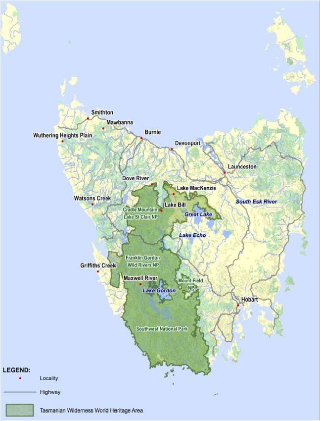
Page 11 of 62Figure 2: Tasmanian Local Government Areas [12] Box 3: The Tasmanian Wilderness World Heritage Area The TWWHA became a UNESCO World Heritage site in 1982. While most sites meet only a couple of criteria for inclusion on the World Heritage List, the TWWHA meets seven; Mount Tai in China is the only other site in the world that meets as many criteria [13]. The TWWHA covers an area of more than 1 million hectares and represents one of the last significant regions of temperate rainforest globally [14]. With some of the last stands of Gondwanan vegetation left in the world, the region is not only environmentally important, but also has significant cultural heritage. There is evidence that Indigenous people lived in the area for more than 20,000 years before colonization in the early 1800s. As discussed throughout this report, the TWWHA is the foundation for Tasmania’s growing tourism industry, which is a key pillar of the economic development strategy for the region. Page 12 of 62
Figure 3: Aerial view of bushfire damage to King Billy pine forest on the slopes of Mt Bobs. Photo credit: Rob Blakers.

                              Figure 4: Tasmanian Wilderness World Heritage Area [15]

                                                                                                                          Page 13 of 62
The Huon Valley Land Use and Development Strategy, adopted by the Huon Valley Council in 2007 [16], describes the
physical and environmental setting of the Huon Valley as making it particularly susceptible to bushfire. The presence
of volatile Eucalyptus together with steep topography have resulted in several major bushfires in the region’s history.
The Strategy further argues that bushfire risk may be increasing due to landscape change as former grazing land is
repurposed to forestry plantation.
Climatic conditions
Styger et al [17] argue that education campaigns such as the ‘fuel stove only’ policy have been very successful in
reducing human ignited fires in the TWWHA. Yet the area burnt by wildfire has increased rapidly since 2000 (see Figure
5), largely as a result of dry lightning ignitions. A fire responder interviewed for this study commented that “before 2000
our major concern was arson, now it’s dry lightning.”
Many studies [17] [8] [18] have found that climate change is increasing the frequency and severity of wildfire across
Tasmania. Fox-Hughes et al [18] found that under the high emissions climate change scenario we are currently on,
Tasmania will see a steady increase in fire danger, particularly in spring. The fire season will lengthen and the number
of days where the forest fire danger index (FFDI) is extreme will increase.
The southwest fires of summer 2018/19 were ignited by lightning. Evidence is mixed as to whether changed weather
patterns from climate change are resulting in more frequent lightning during summer, or if monitoring is simply picking
up more lightning strikes. What is uncontroversial is that climate change is leading to historically low soil and vegetation
moisture - and hence flammability - in what has typically been wet vegetation [7] [8]. Not only is this resulting in an
increased proportion of lightning strikes igniting fires [17], but also fires burning through wet, tall Eucalyptus regnans forest
and rainforest ecotone vegetation, which have traditionally served as natural control lines [7]. One interviewee stated:
“The lightning strikes ignite something and they’ll sit there until the bad weather comes and the smouldering
trees just ignite fires. Until they come out you can’t deal with them. And then they all ignite at once with
the weather.”
Fire ignitions from lightning can smoulder in the landscape for several days until hot, dry and windy weather conditions
turn them into wildfires, which can quickly expand and combine.
Figure 5: Average area burnt per fire season (ha) by lightning fires for five yearly periods between 1980/1981-2014/2015 and 2015/16. Lowess
(segmented regression) line is shown. Reproduced from Styger et al [17]
Page 14 of 62The Tasmanian branch of the United Firefighters Union of Australia stated in its submission to the AFAC report [19] that:
“Firefighters do not profess to be climate change experts or scientists, but firefighters’ experiences are that the
fire seasons are longer, with days of extreme temperatures resulting in more protracted and intense bushfires.”
This perspective is congruent with the discussions the PERC study team had with experienced Tasmanian firefighters.
This experiential evidence or anecdotal reporting is backed up by the science - the AFAC report [7] clearly and strongly
states that:
“Consistent with strong scientific evidence and following the significant fire events in Tasmania in 2013, 2016
and 2019 there is broad acknowledgement and acceptance that projected changes to climatic conditions will
result in longer, more severe fire seasons for the State, as with other parts of the country.”
The perspective from both the fire and emergency management sector in Tasmania, and the scientific literature, is that
since about the year 2000 Tasmania has entered a new fire regime, driven largely by climate change. This new fire
regime has profound implications for fire risk management and firefighting operations, including in the TWWHA.
Page 15 of 62Section II: Socio-Economic Disaster Risk
Management Landscape
Institutional arrangements
Tasmania’s formal bushfire management framework, as shown in Figure 6, sets out the roles and responsibilities of
government organisations. However, bushfire risk management involves much more than this. It involves a network of
state and local government entities, private sector corporations, non-government and community-sector organisations,
and individuals.
At a general level, exposure of property and infrastructure is largely under the formal control of state and local planning
authorities, with involvement of private sector infrastructure providers. Building regulations, which are developed by the
National Building Codes Board and implemented locally, set out requirements to manage the vulnerability of the built
environment. Construction is undertaken by private contractors often with minimal oversight, and this is important in
determining the actual risk. Householders often make alterations to their properties and surrounding landscapes after
the initial build, in turn changing the fire risk. During a bushfire, all fire and emergency service organisations are usually
active in advising and evacuating those at risk.
Figure 6: Tasmanian Bushfire Management Framework. Source: reproduced from [7].
Page 16 of 62The AFAC review sets out the formal arrangements for managing a fire crisis:
“The Emergency Management Act 2006 is the primary overall piece of legislation relevant here, and where
there is an inconsistency, it prevails over other legislation relating to emergency management (Emergency
Management Act, 2006, at s.5).“ [7]
Emergency management committees are established at three levels mirroring the three levels of government: state,
regional and municipal. The roles of the different levels are essentially the same, however, the hierarchy of the different
levels of government is maintained in the committee structure:
“to institute and coordinate, and to support the institution and coordination of, emergency management
including the preparation and review of the ... Emergency Management Plan and Special Emergency
Management Plans that relate to [the jurisdiction] (Emergency Management Act 2006, at ss. 7-9 and 19-22
respectively)” [7]
In addition, the government has discretion to establish a Ministerial Committee chaired by the Premier, including the
State Controller. This committee has the power to operate as determined by the Premier and set out in the Emergency
Management Act 2006 (at s. 12).
Initial responsibility for firefighting operations sits with the organisation - TFS, PWS or STT - who have jurisdiction over
the land where the fire is burning. STT has approximately 220 staff and contract firefighters and is responsible for fires
on state forest. PWS has approximately 200 firefighters and is responsible for fires in reserves. TFS has approximately
250 career firefighters and 4800 volunteers, and is responsible for all other land. TFS is made up of four career brigades
in major towns and 232 volunteer stations throughout the State. Volunteer firefighters are not monetarily compensated
when they take part in fire risk reduction or suppression activities.
Incident Management Teams (IMTs) are activated by Regional and then State Controllers when bushfires escalate beyond
the control of the initial agency responsible, with level 3 IMTs being multi-agency under the coordination of TFS, as set out
in the Tasmanian Interagency Protocol. During such a significant bushfire the State Crisis Centre is activated with the state
Emergency Management Committee in overall command - in close communication with the Tasmanian cabinet.
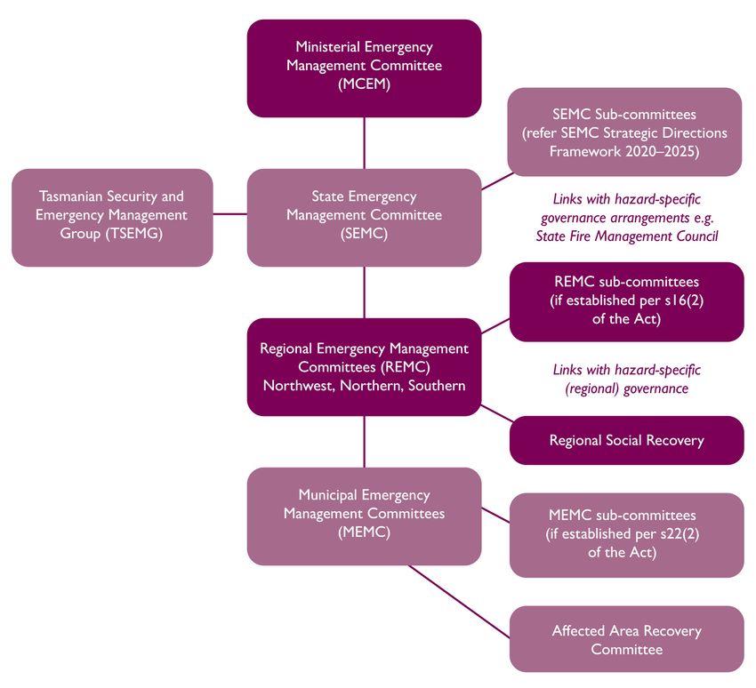
The Tasmanian Emergency management Arrangements (TEMA) sets out the key roles and responsibilities for
emergency response [20], see Figure 7. As a fire threatens, and during a fire, evacuation shelters and related services
for evacuees are run by municipal government and a range of NGOs. Short-term relief and longer-term recovery are
coordinated by regional recovery committees, chaired by the Health Department, consisting of a mix of government
and NGO members. The Southern Regional Social Recovery Committee (the region relevant to the fire examined in
this report) is made up of all NGOs drawn on in an emergency. It meets every three months and undertakes practice in
“peace-time”. Under the relevant legislation, the Health Department is the lead agency for disaster recovery, providing
services and staff. There are three regions in the state. In a bushfire event, local councils are in charge, but they can be
overruled by state agencies. It is notable that the private sector, including insurers and groups with potentially useful
resources that could benefit national and local businesses, are not formally engaged in these arrangements.
Page 17 of 62Figure 7: Tasmanian emergency management governance structure [20] Exposure and vulnerability Socioeconomic conditions The socioeconomic conditions in southwest Tasmania, in particular the Huon Valley Council area, form an important part of the story about wildfire risk in the region. Located in the southern region of Tasmania (see Figure 2), the Huon Valley is a sparsely populated rural municipality with a population of approximately 17,500 [21], a high proportion of whom are elderly [22]. Almost all interviewees spoke of the strong sense of community in the region, and peoples’ willingness to trust and help each other. According to the Australian Bureau of Statistics (cited in [21]) there are 1,255 local businesses in the Huon Valley. The largest industry is Agriculture, Forestry and Fishing; aquaculture employs approximately 20% of employed residents (having almost doubled since the 2012/13 financial year), followed by agriculture at 9%. In contrast, forestry and logging account for only 0.8% of jobs in the Huon Valley, with the number of jobs more than halving in the last 5 years [21]. The Mayor of the Huon Valley also identified the tourism sector as of growing significance; statistics [21] show that food retailing, accommodation, and food and beverage services are growing modestly and providing many jobs in the region. While there is established wealth and prospering businesses in the region, only approximately 42% of residents in the Huon Valley are reportedly employed [21]. While this does not account for informal employment, un- and under- employment – particularly reliance on casual, seasonal jobs – is a concern for the region, resulting in many people being economically vulnerable. Compared to the national average, Tasmania has lower income levels, a higher level of unemployed people than the mainland states and lower levels of literacy and educational attainment [22]. Page 18 of 62
Exposure
The United Nations Office for Disaster Risk Reduction [23] defines exposure as: “People, property, systems,
or other elements present in hazard zones that are thereby subject to potential losses.”
Here we look specifically at trends in exposure to bushfire in southwest Tasmania, starting with population trends.
The population in the Huon Valley is growing modestly. Unlike other regional areas in Tasmania, the Huon Valley has
seen consistent population growth of approximately 0.7% per annum between 2005 and 2015 [22]. The Huon Valley
Economic Development Strategy 2015-2020 [22] identifies retirement migration, consisting of older people, and low
housing prices that are attracting young families, as two key drivers. Interviewees also reported that a portion of the
population growth in the region comes from hobby farmers or ‘tree changers’. The influx of new residents is resulting
in new development in rural areas, which is increasing exposure. GHD [16] reports that these lots are often located right
on the forest boundary, are difficult to access and lack water supplies sufficient for fire suppression.
The tourism industry in the Huon Valley is also growing. NIEIR [21] estimate that in 2017/18 the value of the tourism and
hospitality sales sectors to the Huon Valley Council area was $23.8m. Indeed, growing the tourism sector is the first
pillar of the Huon Valley Economic Development Strategy 2015-2020 [22]. The Strategy recognises the proximity to
Tasmania’s pristine wilderness as a key drawcard for tourists. Growth in environmental tourism further necessitates
growth close to what the tourists have come to see - the forest.
In interviews a town official stated that “a lot of roads are not accessible by emergency vehicles. 70% of our roads are
unsealed. (On) many you can’t pass another vehicle at all.” Narrow and unsealed (unpaved) roads were also raised by
several respondents as an issue for the capacity of community members to evacuate and for emergency vehicles to
access fires.

Vulnerability
The PERC Manual [1] follows UNDRR [23] to define vulnerability as “The characteristics and circumstances of
a community, system or asset that make it susceptible to the damaging effects of a hazard.” It then adds that
“Vulnerability is driven by a combination of physical, social, economic, and political factors.”
In southwest Tasmania the prevailing socioeconomic conditions and demographic trends may be increasing the
vulnerability of people and businesses to bushfire. Interviewees at the Huon Valley Council highlighted concern that an
ageing population together with an influx of new residents - including those who may not have experience with bushfire
risk - may be increasing the vulnerability of residents during fire events. These residents are considered by interviewees
to be less able to manage the risk around their property, evacuate or defend their property. The average age of rural
firefighting volunteers has also increased substantially as the local population has aged.
The fact that a significant proportion of population growth is made up of elderly people and children is a concern for
increasing vulnerability to the impacts of smoke. ONE interviewee – an epidemiologist who works on the impacts of
bushfire smoke on health – warned that people over 65, smokers, those with chronic health conditions, pregnant people
and young children are particularly vulnerable to even small air quality reduction from smoke. Startlingly, they estimated
that 30-60% of the population of southwest Tasmania falls into this vulnerable category.
With regard to the vulnerability of businesses, it is important to note that poor economic growth in the region indicates
that many businesses are already struggling. As a tourism industry expert stated: “Many tourism operators are marginal
anyway, a downturn [for example caused by a bushfire in the region] can push them over the edge.” There is also
concern that Tasmania’s growing viticulture industry is vulnerable to economic loss from both burnt vine and smoke taint
of wine grapes. The suggestion of smoke taint in one area carries a reputational risk for all vineyards across the state.
The community residents that work under these economic conditions are particularly vulnerable when bushfire impacts
the region. A social services employee reported that many residents are casual employees who depend solely on the
summer tourist season: “That’s where the casual workers get their income, a few months over the summer and that
tides them over.” Under these already precarious conditions many residents are highly economically vulnerable to the
type of downturn that a bushfire can bring to tourist numbers in the region, even if they or their employer are not directly
impacted by the fires. Tourists, who typically swell southwest Tasmania during summer, are themselves highly vulnerable
to bushfire. Tourism experts and the AFAC report [7] highlighted that tourists may not speak English, nor be aware of the
need to, or how to, monitor warning messages.

                                                                                                                  Page 19 of 62
Prospective risk reduction
Prospective risk reduction is a term used in disaster research and refers to “actions taken to avoid the build-up of
new or increased risks” [1]. In the case of wildfire, prospective risk reduction is often thought of as involving land use
and building regulations intended to prevent more vulnerable assets being placed in areas at high risk of wildfire.
In regard to prospective risk reduction in the form of land-use planning and building regulations relating to wildfire risk
in Tasmania, overall we find these to be present but limited. Across Tasmania there are building regulations that apply
to new developments, subdivisions and changes in use type in ‘bushfire-prone areas’. These are defined at the Local
Government Area (LGA, municipal council) level, where local planning decisions are made. TFS states [24] that:
A ‘bushfire-prone area’ for the purposes of Tasmanian planning and building legislation includes:
• Land that is within the boundary of a bushfire-prone area shown on an overlay on a planning scheme map; or
• Where there is no overlay on a planning scheme map, land that is within 100m of an area of bushfire-prone
vegetation equal to or greater than 1 hectare.
These building regulations apply in the Huon Valley [25]. When there is a planning application for a new development,
subdivision or change of use within a bushfire-prone area, applicants must comply with building regulations set out in
‘Australian Standard AS3959: Construction of buildings in bushfire-prone areas’ [26] and submit a certified bushfire hazard
management plan. These requirements include provisions such as ensuring the property is accessible to emergency
vehicles, clearance zones between the property and vegetation, and reliable water supply. TFS holds ultimate responsibility
for the certification of bushfire hazard management plans and run an accreditation scheme for building surveyors and
planners to be able to certify plans. An interviewee from TFS stated that “people complain about the work involved [to gain
accreditation], we just hold strong ‘this is about community safety’. We’re not making a profit, if anything it costs us.”
According to interviewees, the bushfire-prone area building restrictions are the extent of prospective risk reduction for
bushfire in Tasmania. Critically, there are no land-use restrictions that might prevent the placement of new assets in high
bushfire-risk areas. Our review of planning regulations concurs with this, although there do seem to be restrictions on
placement of highly vulnerable building types - such as schools, aged care and detention facilities - in high risk areas.
The need for economic growth creates a disincentive for restricting asset growth in bushfire-prone areas. Particularly
in regard to the tourism industry, which is a target growth industry for the state, locating assets in bushfire-prone areas
has economic benefit because these are the areas visitors come to see. At the same time, as discussed above, slow
economic growth is driving vulnerability to bushfires. Development in at-risk areas is therefore a wicked problem within
the disaster-development system [27].
When it comes to the TWWHA, the question of prospective risk reduction takes on a different form. Instead of
prospective risk reduction being about avoiding the build-up of more assets in at-risk areas, it is a question of avoiding
the creation of more risk to the (ecological) asset; an asset that would ideally be increasing. Unfortunately, beyond
reducing emissions, options for arresting increasing bushfire risk in the TWWHA are limited, because bushfire weather
and dry lightning strikes are the main drivers of increasing risk. One, less commonly considered option, could be to
increase the size of the TWWHA to bring in precious but less protected areas on the borders of the TWWHA.
Corrective risk reduction: prescribed burning
Corrective risk reduction is “Actions taken to reduce risk to already at-risk assets” [1]. Other common words include
disaster mitigation and ex-ante risk reduction.
In southwest Tasmania prescribed burning, also known as fuel reduction burning or planned burning, is the mainstay of
corrective risk reduction. Considered the most cost-effective risk reduction strategy [28] [29], prescribed burning is the
deliberate setting of fires by fire services and private landowners in times of low bushfire risk. It is designed for “reducing
the rate of spread and intensity of fires, for minimising the damage caused by bushfires, and to provide fire-fighters with
safe opportunities to contain and extinguish future fires” [29].
Prescribed burning in Tasmania is overseen by TFS via the Fuel Reduction Program, who work in cooperation with
PWS, STT, local councils and private landowners. TFS [28] states that the “cross-agency, whole-of-state fuel reduction
program includes both public and private land, focusing on those areas that pose the greatest risk of bushfire,
regardless of who owns the land.” Tasmania’s 10 Fire Management Area Committees, together with the SFMC, identify
high risk locations. Risk assessments draw on both local knowledge and computer modelling utilising Phoenix RapidFire
and SPARK, as well as the Bushfire Risk Assessment Model (BRAM) tool [7].
Page 20 of 62You can also read