The Corridor Des Arts - LSU Digital Commons - Louisiana ...
←
→
Page content transcription
If your browser does not render page correctly, please read the page content below

Louisiana State University
LSU Digital Commons
LSU Master's Theses                                                                                                              Graduate School

April 2019

The Corridor Des Arts
Kade M. Jones
Louisiana State University and Agricultural and Mechanical College, kjon157@lsu.edu

Follow this and additional works at: https://digitalcommons.lsu.edu/gradschool_theses
   Part of the Landscape Architecture Commons, and the Urban, Community and Regional
Planning Commons

Recommended Citation
Jones, Kade M., "The Corridor Des Arts" (2019). LSU Master's Theses. 4930.
https://digitalcommons.lsu.edu/gradschool_theses/4930

This Thesis is brought to you for free and open access by the Graduate School at LSU Digital Commons. It has been accepted for inclusion in LSU
Master's Theses by an authorized graduate school editor of LSU Digital Commons. For more information, please contact gradetd@lsu.edu.
THE CORRIDOR DES ARTS

               A Thesis

Submitted to the Graduate Faculty of the
    Louisiana State University and
 Agricultural and Mechanical College
      in partial fulfillment of the
    requirements for the degree of
   Master of Landscape Architecture

                   in

 The School of Landscape Architecture

                   by
          Kade Michael Jones
B.F.A., Louisiana State University, 2015
               May 2019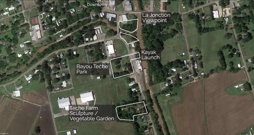
Copyright 2019 Kade Michael Jones

               ii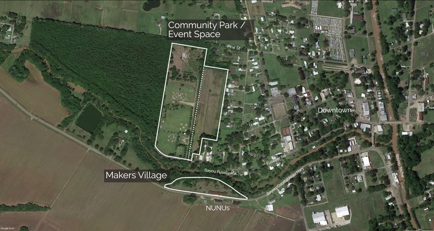
Acknowledgments

       I express my gratitude to my committee chair Professor Lake Douglas for

encouraging me to succeed during significant moments of my graduate studies. I sincerely

thank Professor Bruce Sharky and Professor Traci Birch of my thesis committee for being

mentors, holding insightful discussions, and emboldening me to think open-mindedly

about challenges. I would also thank the rest of the faculty and staff of the Robert Reich

School of Landscape Architecture for educating me about our profession.

       I would like to thank the members of NUNU Art and Culture Collective, including

a special thanks to George Marks and Jackie Cochran, whose hospitality and willingness

to meet with me were invaluable to the development of this thesis.

       I express a very special gratitude to the Dean of the College of Art and Design,

Alkis Tsolakis, who has been a mentor and friend to me since 2013.

       I would like to thank my studio mates, the M.L.A. class of 2019: Josh Black, Taylor

Fehmel, Phil Fernberg, Peihong Han, Chadd Hippensteel, Surabhi Jain, Xiaoman Ji, Sophie

Lott, Yuta Masakane, Mai Nguyen, Murong Xu, and Yue Zhang. I will forever cherish the

times that we’ve spent together.

       Finally, I would like to thank my mother and father, Maria and Timmy Jones for

the unfailing love and support, as well as all of the rest of my family whom have supported

me along the way.

                                            iii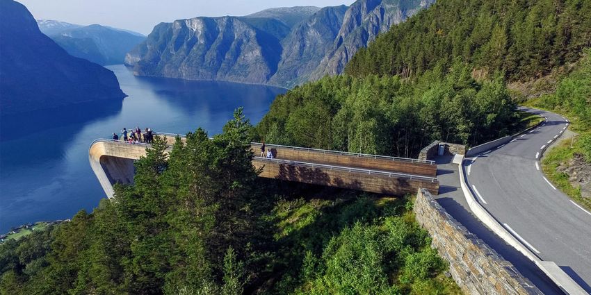
Table of Contents

Acknowledgments.............................................................................................................. iii

Table of Contents ............................................................................................................... iv

Abstract ............................................................................................................................... v

Chapter I. Introduction ........................................................................................................ 6
       Corridor des Arts..................................................................................................... 6
       NUNU Art and Culture Collective ......................................................................... 7
       The Open Studio Tour ............................................................................................ 9

Chapter II. Creative Placemaking in Rural Communities ................................................ 10
       Defining Creative Placemaking ............................................................................ 10
       Success through Creative Placemaking ................................................................ 11

Chapter III. Defining Rural and the Need for Rural Planning .......................................... 12
       What Does it Mean to be Rural? ........................................................................... 12
       Challenges Faced by Rural Communities ............................................................. 12
       Multi-Functionality of Roads and Traffic Calming .............................................. 14

Chapter IV. Cultural Landscapes ...................................................................................... 16
       What is a Cultural Landscape? ............................................................................. 16
       Arnaudville as a Vernacular Landscape ............................................................... 16

Chapter V. Precedent Studies ........................................................................................... 18
       The National Tourist Routes, Norway .................................................................. 18
       Les Rencontres de la Photogaphie, Arles ............................................................. 20
       Socrates Sculpture Park, New York City .............................................................. 21
       Playable Cities ...................................................................................................... 22

Chapter VI. The Design Process ....................................................................................... 25
       Site Analysis ......................................................................................................... 25
       Site Design ............................................................................................................ 25

Chapter VII. Conclusion ................................................................................................... 30
       Goals ..................................................................................................................... 30

Bibliography ..................................................................................................................... 32

Vita .................................................................................................................................... 35

                                                                    iv
Abstract

       Arnaudville is a small rural town in south central Louisiana with a population of

1200. In 2010, the National Endowment of the Arts (NEA) named Arnaudville as one of

fourteen cities that were classified as a successful case study of “Creative Placemaking.”

The NEA defines creative placemaking as community partnerships that use arts and culture

to shape the social, environmental, and economic identity of a place. The NUNU Arts and

Culture Collective, a Louisiana Cajun French non-profit arts organization centered in

Arnaudville, is the main catalyst of this effort.

       Members of NUNU have identified five other rural towns within close proximity

to Arnaudville as locations of cultural value, all just west of the Atchafalaya Basin: Sunset

(2,298), Grand Coteau (935), Arnaudville (1,067), Cecilia (1,980), and Henderson (1,722),

and they are connected by what they call the “Corridor des Arts.” These five communities

represent an arc of 21.7 miles envisioned as the first phase of an eventual circle that will

include, when complete, a number of communities in the region. Each rural town represents

a different aspect of Louisiana French culture, including art, crafts, music, and food. The

mission of the Corridor des Arts is to tie these towns together via an art and culture trail

through the connecting roads and highways. The aim of this research is to explore how the

concept of creative placemaking can be applied through the practice of landscape

architecture to conserve the communities’ unique cultural heritage, increase economic

activity, and establish environmental stability. The scope of work will focus on the design

of projects in the town of Arnaudville as the center of the Corridor des Arts.

                                               v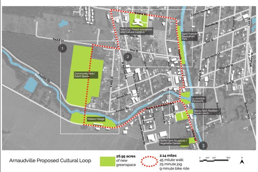
Chapter I.

                                              Introduction

         Corridor des Arts

         A small group of artists and merchants from the Louisiana towns of Sunset, Grand

Coteau, and Arnaudville gathered in April 2012 to discuss how to better market and

promote local art. The group identified artists and venues along an existing set of roads in

the Acadiana region connecting these towns that showcase the work of local artists in

neighboring communities all within the designated Louisiana Cultural Districts of St.

Landry and St. Martin Parishes. The primary goal of the Louisiana Cultural Districts

Program is to “spark community revitalization based on cultural activity through tax

incentives, technical assistance, and resources.”1 The Corridor des Art group’s focus

quickly narrowed to joining communities together through promotion of culture and

presentation of local art. From this small group of creative individuals, the concept of the

Corridor des Arts was born.

         Throughout the following months, the Corridor des Arts Committee was

established with representatives from the towns of Sunset, Grand Coteau, and Arnaudville.

To operate as a non-profit, Corridor des Arts Committee partnered with a local

collaborative arts group called the NUNU Art and Culture Collective. The Corridor des

Arts Committee contacted each venue and artist within the 21.9-mile corridor and invited

1
 Louisiana Cultural Districts | Office of Cultural Development, www.crt.state.la.us/cultural-
development/arts/cultural-districts/.

                                                     6
them to be a part of Corridor des Arts, with the goal of showcasing art year-round and

offering bi-annual open studio tours.

Map of the Corridor des Arts

       NUNU Art and Culture Collective

       The NUNU Arts and Culture Collective is a 501(c)3 non-profit arts and culture

incubator centered in Arnaudville, Louisiana with a focus on Louisiana Cajun French

culture and heritage. The NUNU Collective’s mission statement is to “work to encourage

the development of artistic talents, skills, knowledge and business savvy by connecting

artists with other artists, businesses, organizations and programs. It serves as a

stage/platform/gallery for creative living by facilitating community, economic, and

                                          7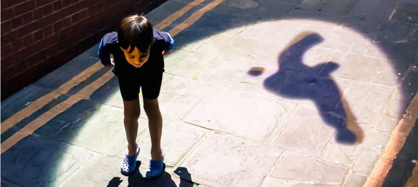
artistic/cultural development.”2 Established in 2005, this group of creative thinkers is the

main catalyst of the Corridor des Arts project. The physical establishment of the NUNU

Collective relocated to a new building in Arnaudville in February 2018 after a man crashed

his vehicle into the building, which was also a historic sweet potato warehouse, resulting

in a fire that destroyed an estimated $60,000 of art.3 Being situated in a new building, the

NUNU Collective is an example of the resilience needed to thrive in rural communities.

Being an active mouthpiece of the Corridor des Arts project and the Open Studio Tour, the

group has established a demand for design interventions and systems that may facilitate a

sustainability in small rural communities.

NUNU Art and Culture Collective, Arnaudville

2
 “About,” NUNU Collective. https://nunuaccollective.homesteadcloud.com/about.
3
 Fatherree, Dwayne. “Historic Building, Part of Nunu's Art and Culture Collective in Arnaudville,
Destroyed.” News15 | Lafayette, LA, 4 Feb. 2018, kadn.com/historic-building-part-of-nunus-art-and-
culture-collective-in-arnaudville-destroyed/.

                                                   8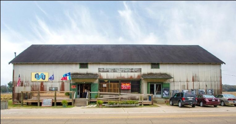
The Open Studio Tour

       The first Corridor des Arts Fall Open Studio Tour was in November of 2012 and

was sponsored by both St. Landry Parish and St. Martin Parish tourist commissions. The

tour featured venues, studios, and galleries within several communities of the corridor.

Upon reviewing and evaluating the results of the tour, it was discovered that the result was

an increase in tourism and a demand for continued art displays along the corridor. The 2013

Corridor des Arts Spring Open Studio Tour featured the addition of the community of

Cecilia, Louisiana, an outside market of juried artists, and local musicians showcasing

Acadian and Creole culture. The Corridor des Arts Open Studio Tours presented the

opportunity for a future vision of creativity and economic development. As the Corridor

des Arts continued to grow, new communities have been added as well as community

representatives. The Corridor now includes the town of Henderson in St. Martin Parish,

and with this addition a link to the major Interstate 10.

       The Corridor des Arts is a grassroots effort by local merchants, cultural workers,

area residents and artists. It is dedicated to the continued growth and expansion of

participants for the purpose of community and cultural economy. It serves to create new

partnerships and expand opportunities for businesses and communities in rural areas that

do not have the funding or cultural resources necessary to command public attention.

                                              9
Chapter II.
Creative Placemaking in Rural Communities
Defining Creative Placemaking
The National Endowment of the Arts (NEA) is “an independent federal agency that
funds, promotes, and strengthens the creative capacity of our communities by providing all
Americans with diverse opportunities for arts participation.”4 In 2010, the NEA named
Arnaudville as one of fourteen cities that were classified as a successful case study of
“Creative Placemaking.” The NEA defines creative placemaking as “community
partnerships that use arts and culture to shape the social, environmental, and economic
identity of a place.”5 Focusing on the social and cultural capitals of a community to
influence physical spaces, partnered with spatial planning that focuses on safety and
comfort will create a destination that promotes economic development and the general
welfare of the town. Creative placemaking requires characters from within the community
that display traits of determination and originality that will initiate and activate the public.
When the members of a community are connected to a collaborative group, they gain the
agency of power in regard to the decisions made about the place in which they live.
Through the acknowledgement of the problems faced by a community, plans of
revitalization can animate a space, resulting in economic development. Economic
development in turn results in a higher standard of livability, employment opportunities,
and social diversity.
4
“NEA,” National Endowment of the Arts. https://www.arts.gov (accessed September 25, 2018).
5
Markusen et al., Creative Placemaking (Washington, D.C., National Endowment for the Arts, 2010).
10Success through Creative Placemaking
Successful creative placemaking requires a local initiator with for the location and
the drive to activate the community. The initiator, be it an entity or a highly motivated
individual or leader, develops strategies to define the unique characteristics of a place. The
initiator will then engage the public, leading to collaborative efforts that will incentivize
private sector financial opportunities, as a well-established plan will have multiple sources
of potential funding. Plans, designs, and local programs will include artists and leaders of
culture, history, and vernacular. The establish placemaking plan will then further attract
entities that are both private or governmental for the continued sustainability to the place.
.
Creative Placemaking Diagram, Markusen, Ann, and Anne Gadwa. Creative Placemaking.
Washington, D.C.: National Endowment for the Arts, 2010.
11Chapter III.
Defining Rural and the Need for Rural Planning
What Does it Mean to be Rural?
The term “rural” is often associated with specific images of fields and farms, small
houses on large landscapes, and certain stereotypes of social identifications. While the
delineation of urban to rural edges may often be ambiguous and hard to determine, The
U.S. Census Bureau defines rural as “what is not urban; that is, after defining individual
urban areas, rural is what is left.6” Those responsible for planning and design solutions
must address the needs and desires of rural communities much differently than their urban
counterparts. Communities are often described as being rural when they share a “cohesive
identity linked to an extensive landscape.”7 Towns are often identified as rural based on
the proximity to other towns or urban centers. While there are generally fewer resources, a
certain level of ingenuity and innovation are required to compensate for the resources that
urban residents may have access to while those that live in rural communities do not.
Challenges Faced by Rural Communities
Rural communities share common challenges with urban communities but also face
a set of challenges that are unique. These challenges are generally related to isolation and
low levels of resources. Rural areas suffer from economic and financial disparities due to
lower incomes and fewer employment opportunities than urban areas, resulting in a
6
Ratcliffe et al., Defining Rural at the U.S. Census Bureau: American Community Survey and Geography
Brief (United States Census Bureau, 2016.)
7
Cloke et al., Handbook of Rural Studies (SAGE Publications Ltd; 1 edition, 2006) 20-21
12prevalence of poverty. In the instance of Arnaudville, the median household income is
$38,583, which is below the median annual income of the state of Louisiana ($45,146).
The largest industries in Arnaudville are retail trade and construction.8
Rural towns require proactive responses to social issues of race, class, age, and
income, as different demographic groups require specific service needs. As a community
becomes more diverse, new solutions must be developed in order to manage intra-class
conflicts.9 When planning for rural communities, strategic partnerships must be established
to mobilize the community, encouraging communication and equitability. To combat social
exclusion, affordability of housing must be considered. When this is ignored, people of
lower incomes are marginalized because keeping up with rising economies can be
challenging. Equal opportunity for employment can be achieved through several strategies
such as seasonal employment, training programs for vocational skills and self-employment,
and an emphasis on tourism and the unique assets of said communities.
Partnership opportunities with the universities of nearby cities such as the
University of Louisiana at Lafayette or Louisiana State University in Baton Rouge
introduce new education opportunities to rural communities. While health trends in rural
towns are generally better than those in urban environments, access to hospitals, doctors,
and other health facilities is limited due to proximity. The nearest hospital to Arnaudville
is St. Martin Hospital in Breaux Bridge, which is thirteen miles away by car, or an average
of twenty minutes.
8
“Arnaudville,” Data USA. https://datausa.io/profile/geo/arnaudville-la/#economy (accessed October 8,
2018).
9
Gallent et al., Introduction to Rural Planning (Routledge, 2008), 25.
13When considering spatial planning for rural towns, a range of alternative
transportation methods must be provided. Dependency on vehicular traffic and a lack of
transportation variety and accessibility promotes social exclusion. Nationally, traffic and
transportation enforcement tend to be more difficult in rural communities. “Of the 37,461
motor vehicle traffic fatalities in 2016, there were 18,590 (50%) that occurred in rural areas,
17,656 (47%) that occurred in urban areas, and 1,215 (3%) that occurred in unknown
areas.”10 With nearly half of vehicular fatalities occurring in rural areas, especially
considering this statistic relative to populations of rural towns juxtaposed to urban areas, it
is clear that solutions of both design and enforcement are necessary.
Multi-Functionality of Roads and Traffic Calming
In order to address the need for safe and active travel in small and rural towns,
planners and designers must consider a range of speed control and traffic calming solutions
to encourage multi-functionality of the use of roadways. Alternate forms of transportation
can serve the double purpose of recreation and travel, and the design of roadways to
facilitate these different types of transportation can be used to address the need for
vehicular speed control. Several traffic calming methods can be utilized to achieve this.
Visual design solutions such as landscape plantings, entrance signs, and gateways improve
the aesthetics of a town and encourage drivers to slow down. It also offers the opportunity
to develop a unique identity of branding and cohesive design style for the town. Having a
change of road materials can help to delineate a hierarchy of vehicular and pedestrian
priority. The repurposing or reassigning of lanes is another method to control speeds and
10
Traffic Safety Facts (National Highway Traffic Safety Administration, 2018).
14traffic. Lane conversions from strictly vehicular to multifunctional, the restriping of lanes
to incorporate bike and pedestrian lanes, the widening of shoulders when plausible, and the
introduction of a pedestrian element to otherwise vehicular only roads can work to
encourage drivers to be aware and slow down. More direct speed solutions may also be
utilized such as speed bumps, transverse rumble strips, dynamic speed displays,
roundabouts, and bollards.11
11
Hallmark et al., Speed Management Toolbox for Rural Communities (Center for Transportation Research
and Education, Institute for Transportation, Iowa State University, 2013).
15Chapter IV.
Cultural Landscapes
What is a Cultural Landscape?
The Cultural Landscape Foundation defines cultural landscapes as “landscapes that
have been affected, influenced, or shaped by human involvement.”12 Cultural landscapes
range in size from small private lots to large regional landscapes and may include works
of art, cultural narratives, or examples of regional identity. There are four categories
defined by the Cultural Landscape Foundation: designed landscapes, ethnographic
landscapes, historic sites, and vernacular landscapes.12 Vernacular landscapes are defined
by the Cultural Landscape Foundation as
landscapes that evolved through use by the people whose activities or occupancy
shaped those landscapes. Through social or cultural attitudes of an individual,
family, or a community, the landscapes reflect the physical, biological, and cultural
character of those everyday lives (The Cultural Landscape Foundation).
Arnaudville as a Vernacular Landscape
Arnaudville sits just west of the Atchafalaya Basin at the junction of Bayou Teche
and Bayou Fuselier, representing an area of just 0.7 square miles. Arnaudville is twenty-
one miles north of Lafayette, fifty miles from Baton Rouge, and one-hundred thirty miles
from New Orleans. The local nickname of the town is the “Jewel of the Teche.” The
original name of the town was La Murière, then later name La Jonction, which is French
12
“About Cultural Landscapes.” About Cultural Landscapes | The Cultural Landscape Foundation,
tclf.org/places/about-cultural-landscapes.
16for the junction. In the nineteenth century, a pair of brothers from Jausiers, France with the
surname Arnaud donated large amounts of land to establish a desegregated church that
would be for both the white and black communities. At this point the town received its
final name, Arnaudville.13 Arnaudville was the original home of the Attakapas Native
Americans, settled by the French in the late eighteenth century, and incorporated as a town
in 1870. The town is a part of both St. Landry and St. Martin Parishes, which are located
in Louisiana’s intrastate region known as Acadiana. Acadiana is home to the majority of
Louisiana’s Francophone population of Acadian descendants, or Cajuns. The name
“Acadiana” was established in 1971 and classifies twenty-two Louisiana parishes that share
“a similar cultural environment of strong French Acadian cultural aspects.”14
Based on the concept of vernacular landscapes, the goal of any plan or design
should be to emphasize the unique cultural characteristics of the space, particularly the
Cajun and Creole French culture and history.
13
“Louisiana History: Old and New Place Names.” Cajun and Cajuns: Genealogy Site for Cajun, Acadian
and Louisiana Genealogy, History and Culture, www.thecajuns.com/oldnew.htm.
14
Carl W. Bauer, House Concurrent Resolution NO. 496 (1971)
17Chapter V.
Precedent Studies
The National Tourist Routes, Norway
Norway is home to a nationwide project of landscape architecture, infrastructure,
art and human interaction with nature. The National Tourist Routes of Norway encompass
eighteen scenic roads that meander through the mountains of south Norway, stretching
along Norway's west coast. Each route features multiple architectural and sculptural
attractions that are centered around the natural landscape. The routes supply travel
destinations, restaurants, and accommodations for tourists. The national scale of the project
incorporates many aspects of landscape architecture as well as innovative engineering and
contemporary design. Many of the projects along these routes have won national and global
awards for art and aesthetics for their cutting-edge styles. As a development that is
supported by the government of Norway and the local communities, it will prove to be a
long-term boost to the economy in terms of tourism and the sense of locality that it provides
the community.
The National Tourist Routes in Norway began in 1994 as four projects were
commissioned by the Norwegian Public Roads Administration. This is the entity that is
responsible for overseeing the wellbeing of all state and county roads and is given one of
the largest long-term budgets in Norway as a governmental agency. “The Norwegian
Public Roads Administration strives to ensure that all those who walk, cycle, travel by car
or use public transport should get to their destination safely. They plan, build, operate and
18maintain national and county roads in Norway. They are also responsible for carrying out
driver tests and inspection of vehicles and road users.”15
The first four routes, Sognefjellsvegen, Gamle Strynefjellsveg, Hardanger and
Helgelandskysten, were given the status of national tourist routes in 1997. The following
year, the national government of Norway, the Storting, approved a plan for the
development of the National Tourist Routes project. The municipalities of Norway were
asked to nominate notable roads within their regions to be developed and updated to the
National Tourist Routes quality standards, and this resulted in fifty-two nominations. In
2005, eighteen of the nominated roads were selected to be designated as National Tourist
Routes. The roads were then updated and populated with new attractions and architecture,
and the project was promoted at conferences and exhibitions, receiving multiple awards.
All eighteen routes were officially designated with the National Tourist Routes status by
2012. Updates continue to take place in regard to rest stops and service facilities, but all
developments are scheduled for completion by 2023. The eighteen routes are listed as
follows: Jæren, Ryfylke, Hardanger, Hardangervidda, Aurlandsfjellet, Valdresflye,
Gaularfjellet, Sognefjellet, Gamle Strynefjellevegen, Rondane, Geiranger - Trollstigen,
Atlanterhavsvegen, Helgelandskysten, Lofoten, Andøya, Senja, Hovøysund, and Varanger.
15
“The Norwegian Public Roads Administration Is a New CITA Full Member.” CITA International Motor
Vehicle Inspection Committee -, citainsp.org/2018/12/12/14978/.
19Stegastein, Aurlandsfjellet, Visit Norway. visitnorway.com
Les Rencontres de la Photogaphie, Arles
The annual Rencontres d’ Arles is a photography exhibition that takes place in the
historic city of Arles, which is located in the Camargue natural region of southern France.
The festival was founded in 1970 under the original name, Rencontres Internationales de
la Photographie d’Arles, by three individuals: photographer Lucien Clergue, author Michel
Tournier, and historian Jean-Maurice Rouquette. Since 1970, the summer photography
festival has attracted visitors from around the world, reaching as many as one hundred and
forty thousand in 2018.16 The Rencontres d’Arles features studio art tours, lectures, parties,
and several programs that showcase the historic assets of Arles, France such as museums,
chapels, and industrial buildings. The exhibitions animate both indoor and outdoor spaces,
filling the streets with public art and activating vacant buildings with surreal photo
displays. The global impact of the festival is profound as it has been a platform of discovery
16
d'Arles, Les Rencontres. “About the Festival.” About the Festival - Les Rencontres D'Arles,
www.rencontres-arles.com/en/a-propos-du-festival/.
20for many photographers and creative individuals. The work displayed in the festival is
exclusively unpublished work, encouraging the discovery of many new artists.
Rencontres d’Arles, SNCF Gares & Connexions - David Paquin. https://www.gares-
sncf.com/fr/actualites/rencontres-darles-festival-photographie-renomme-mondial-
decouvrir-4-gares-jusquau-24.
Socrates Sculpture Park, New York City
The Socrates Sculpture Park is located one block from the Noguchi Museum along
the East River, close to the neighborhood of Astoria, Queens, New York. The four-acre
park was established by the American sculpture artist, Mark di Suvero, in 1968 at the site
of abandoned landfill and illegal dump site.17 Through the efforts of local artists and youth,
the site was rehabilitated and developed into New York’s largest space for public sculpture
displays. The park was operated for fourteen years as a temporary city park, until it was
17
“Mission & History.” Socrates Sculpture Park, socratessculpturepark.org/about-us/mission-and-history/.
21designated as an official park by the New York City mayor Rudolph Giulliani in 1998.18
Since the parks creation, the open studio and exhibition space has presented over a
thousand artists. The park hosts several tours, workshops, and programs for the public such
as summer projects. It is also the site where GrowNYC, a local non-profit with the mission
of improving New York City’s quality of life, holds the Astoria Farmer’s Market every
Saturday during the summer.
The Socrates Sculpture Park, socratessculpturepark.org
Playable Cities
Playable Cities is a campaign that spans five continents in the cities of Melbourne,
Austin, Seoul, Oxford, São Paulo, Tokyo, Lagos, Recife, and Bristol.19 The campaign
was developed by the film culture and digital media center Watershed, located in Bristol,
18
Martin, Douglas. “Queens Sculpture Garden Is Made a Permanent Park.” New York Times, 6 Dec. 1998,
www.nytimes.com/1998/12/06/nyregion/queens-sculpture-garden-is-made-a-permanent-park.html.
19
“Playable City Is A Framework to Think Differently About Your City.” Playable City,
www.playablecity.com/cities/.
22with the goal of developing cultural engagement. Each city in the Playable City campaign
has developed a unique approach to forming a local identity through art and public
interaction. The featured art often addresses opportunities and constraints within the city
such as pedestrian safety and social isolation and offers the community a new form of
dialogue. Playable City projects are typically interactive and engaging to the public,
inducing a human response that brings a social cohesion to the community. The projects
are established during collaborative workshops as prototypes that are later developed into
executable ideas, through public art installations and residential labs.
Stop, Smile, Stroll is an example of a Playable Cities project located in Bristol.
The concept involves transforming a pedestrian crosswalk into a thirty second game, in
which the user interacts with a camera attached to the stoplight at intersections. A screen
asks the pedestrian a question, and records the interaction, then displays the moment for
the next user, usually with humorous graphics, establishing a running dialogue of people
who have interacted at the intersection.20 Stop, Smile, Stroll was the Playable City Award
2016 winner. Playable City projects are generally playful and bring strangers together.
Stop, Smile, Stroll, Playable Cities. https://www.playablecity.com/projects/stop-smile-
stroll/
20
“Stop, Smile, Stroll.” Playable City, www.playablecity.com/projects/stop-smile-stroll/.
23Another example of a Playable City project is called Shadowing, an installation
that also uses augmented streets lights in the cities of Austin, Tokyo, and Bristol to create
a user experience, but in a unique way. The concept is that a pedestrian walks under an
overhead streetlight, their movement is recorded by a camera, then projected back to the
ground seconds later in the form a shadow. The footsteps of the person are then looped as
a shadow continuously, so that when the next pedestrian walks near it, the shadow can be
seen on the ground.21 The effect is that it grabs the attention of people as they pass by
which causes them to stop to explore their curiosity. Shadowing was the recipient of the
Playable City Award in 2014.
Shadowing, Playable Cities. https://www.playablecity.com/projects/shadowing/
21
“Shadowing.” Playable City, www.playablecity.com/projects/shadowing/.
24Chapter VI.
The Design Process
Site Analysis
Site analysis for this project involved driving to Arnaudville and meeting with
members of NUNU Art and Culture Collective to determine the needs and desire for the
town. Through meetings involving mapping and public discussion, sites were determined
to develop a system of green spaces in the form of a loop through the town. The site will
work to promote economic development through cultural experiences that showcase the
cultural heritage and history of the sites. Arnaudville was documented by photographs and
by video, both in the form of a camera attached to the dash of the car and by drone.
Site Design
The proposed plan will be a system of public community spaces throughout the
town of Arnaudville that will facilitate the program demands of the community, as well as
the network of roads connecting them. The sites shall have an aspect of multi-functionality
and variety of programming. As per the concept of creative placemaking, the designs shall
emphasize the unique social aspects of Arnaudville, namely the French culture and
heritage. Best practices of rural planning and landscape architecture shall be applied in all
aspects of the design to ensure organization of spaces that will promote the safety and
comfort of pedestrians using the spaces.
25Arnaudville Proposed Cultural Loop Plan
A nine-and-a-half-acre community event and festival ground will serve the function
of facilitating large festivals that occur seasonally but will also serve the community year-
round. Methods of storm water management will be required to address areas of water
retention on the site. The site is located along the Bayou Fuselier, and a pedestrian bridge
will be installed which will connect directly to NUNU Art and Culture Collective. The site
is located parallel to the existing twenty-acre Arnaudville recreational complex, so the
circulation will address both sites. Programming for the event space will be multi-
functional with features such as a stage for music performance, a drive-in, and a water
retention pond planted with native vegetation. The site will feature both active and passive
spaces, including a large open space for sports, a children’s playground, and a picnic area.
26The Makers Village is a five-acre park located along Bayou Fuselier across the street from
NUNU Art and Culture Collective. It will be a site designated for the development of crafts
and sculptures, allowing space for vendors to come and sell their creations.
Plan of the Community Park / Event Space and the Makers Village
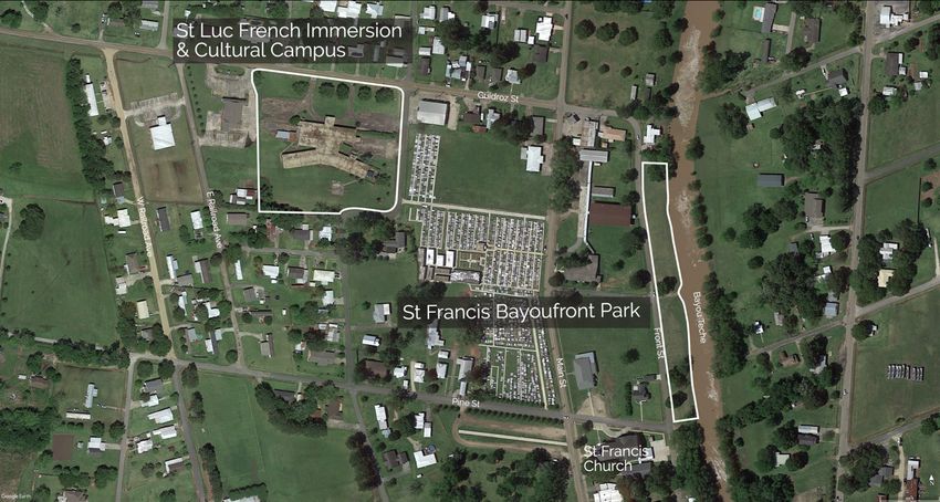
The five-acre Saint Luc French Immersion and Cultural Campus will be a place of
education for people of all ages, offering opportunities for a full Creole and Cajun French
experience. In close proximity to the Saint Luc French Immersion and Cultural Campus
will be the Saint Francis Bayou Park which will allow visitors to relax and experience
Bayou Teche.
27St. Luc French Immersion and Cultural Campus and the Saint Francis Bayou Park
The Bayou Teche Park and Kayak Launch is a two-acre site that will restore
water recreation to Bayou Teche and will be connected to the two- acre Teche Farm
Sculpture and Vegetable Garden. A key site in the overall plan will be the La Jonction
Viewpoint, which is a one-and-a-half-acre moment of land that sits at the Junction of
Bayou Teche and Bayou Fuselier. The site will feature terraced banks that allow visitors
to sit at on the oldest parts of Arnaudville.
28La Jonction Viewpoint, Bayou Teche Park and Kayak Launch, and Teche Farm Sculpture
and Vegetable Gardens
29Chapter VII.
Conclusion
Goals
To conclude this thesis research, the of design in landscape architecture for the
Corridor des Arts will be driven by the concepts of creative placemaking, rural planning,
and cultural landscapes. Through an understanding of the local cultural capital and
vernacular, designs will be established that reflect the unique aspects of Arnaudville that
promote economic incentive and establish the Corridor des Arts as an asset to the future of
Louisiana.
The goal of this design thesis is to utilize the cultural and ecological systems
develop and maintain the regional identity of a site and strengthen the bonds among rural
communities and the people who live there. With a focus on the cultural landscape, the
NUNU Arts and Culture Collective works to preserve and showcase Louisiana Cajun
French culture through a number of programs. The town of Arnaudville is the central hub
for the Corridor des Arts from which activities radiate out into the other towns. The
methodologies utilized in the development of the site designs for Arnaudville may be
replicated with the towns in further completion of the Corridor des Arts.
The expected result of this design thesis will be to complete designs for the first
phase of the Corridor des Arts, which includes Sunset, Grand Coteau, Arnaudville, Cecilia,
and Henderson. The future vision of the Corridor des Arts will connect many cities
throughout south central Louisiana, each town representing a unique aspect and focus of
Louisiana Cajun French culture (such as but not limited to art, language, music, culinary
interest, history, etc.).
30The design intervention will be site specific designs for projects within the rural
towns included in phase one, and to curate the roads between them through both vehicular
methods and alternative transportation methods such as bike lanes, recreational waterway
travel, and public transportation, which will include a wayfinding signage program with a
cohesive design language representing the local vernacular.
.
31Bibliography
“About Cultural Landscapes.” About Cultural Landscapes | The Cultural
Landscape Foundation, tclf.org/places/about-cultural-landscapes.
“About,” NUNU Collective. https://nunuaccollective.homesteadcloud.com/about.
“Arnaudville,” Data USA. https://datausa.io/profile/geo/arnaudville-la/#economy
(accessed October 8, 2018).
Beardsley, John. Harvard Design Magazine: A Word for Landscape Architecture.
Accessed May 01, 2018. http://www.harvarddesignmagazine.org/issues/12/a-word-for-
landscape-architecture.
Bolchover, Joshua, John Lin, and Christiane Lange. Designing the Rural: A
Global Countryside in Flux. Hoboken, NJ: John Wiley & Sons, 2016.
Boyle, Susan, Susan Buggey, and Michael Caratzas. Balancing Nature and
Culture in Historic Landscapes. Hancock, MI: George Wright Society, 1996.
Carl W. Bauer, House Concurrent Resolution NO. 496 (1971)
Cloke et al., Handbook of Rural Studies (SAGE Publications Ltd; 1 edition, 2006)
20-21
Deming, M. Elen. Values in Landscape Architecture and Environmental Design:
Finding Center in Theory and Practice. Baton Rouge (La.): Louisiana State University
Press, 2015.
Elizabeth England (2017) The Archive of Place and Land Art as Archive: A Case
Study of Spiral Jetty. The American Archivist: Fall/Winter 2017, Vol. 80, No. 2, pp. 336-
354.
Fatherree, Dwayne. “Historic Building, Part of Nunu's Art and Culture Collective
in Arnaudville, Destroyed.” News15 | Lafayette, LA, 4 Feb. 2018, kadn.com/historic-
building-part-of-nunus-art-and-culture-collective-in-arnaudville-destroyed/.
Gallent, Nick, Meri Juntti, Sue Kidd, and David Shaw. Introduction to Rural
Planning: Economies, Communities and Landscapes. New York: Routledge - Taylor &
Francis Group, 2015
Girot, Christophe, and Dora Imhof. Thinking the Contemporary Landscape. New
York: Princeton Architectural Press, 2017.
Hallmark et al., Speed Management Toolbox for Rural Communities (Center for
Transportation Research and Education, Institute for Transportation, Iowa State
University, 2013).
32Hvattum, Mari. Routes, Roads and Landscapes. Farnham, Surrey: Ashgate Pub.,
2011.
Jackson, John Brinckerhoff. Horowitz. Landscape in Sight: Looking at America.
New Haven, CT: Yale Univ. Press, 2000.
Lippard, Lucy R. The Lure of the Local: Senses of Place in a Multicentered
Society. New York: New Press, 1998.
Lowenthal, David, Donald Appleyard, Kevin Lynch, and John R. Myer. "The
View from the Road." Economic Geography 42, no. 3 (1966): 276. doi:10.2307/142014.
Louisiana Cultural Districts | Office of Cultural Development,
www.crt.state.la.us/cultural-development/arts/cultural-districts/.
“Louisiana History: Old and New Place Names.” Cajun and Cajuns: Genealogy
Site for Cajun, Acadian and Louisiana Genealogy, History and Culture,
www.thecajuns.com/oldnew.htm.
Markusen, Ann, and Anne Gadwa. Creative Placemaking. Washington, D.C.:
National Endowment for the Arts, 2010.
Martin, Douglas. “Queens Sculpture Garden Is Made a Permanent Park.” New
York Times, 6 Dec. 1998, www.nytimes.com/1998/12/06/nyregion/queens-sculpture-
garden-is-made-a-permanent-park.html.
Meinig, D. W. The Shaping of America: A Geographical Perspective on 500
Years of History. New Haven, CT: Yale University Press, 2004.
“Mission & History.” Socrates Sculpture Park, socratessculpturepark.org/about-
us/mission-and-history/.
Morris, Joe. Rural Planning and Management. Cheltenham: Edward Elgar, 2001.
“The Norwegian Public Roads Administration Is a New CITA Full
Member.” CITA International Motor Vehicle Inspection Committee -,
citainsp.org/2018/12/12/14978/.
“NEA,” National Endowment of the Arts. https://www.arts.gov (accessed
September 25, 2018).
“Playable City Is A Framework to Think Differently About Your City.” Playable
City, www.playablecity.com/cities/.
Ratcliffe et al., Defining Rural at the U.S. Census Bureau: American Community
Survey and Geography Brief (United States Census Bureau, 2016.)
33Ren, Yue, "Experiential Landscape Architecture: Land Art, As a New Language
in Landscape Architecture and A New Opportunity for Public Space Design" (2015).
Master of Landscape Architecture Terminal Projects. 6.
https://tigerprints.clemson.edu/mlatp/6
d'Arles, Les Rencontres. “About the Festival.” About the Festival - Les
Rencontres D'Arles, www.rencontres-arles.com/en/a-propos-du-festival/.
Schuler, Timothy. "THE ART OF INFRASTRUCTURE." Landscape
Architecture Magazine. April 03, 2017. Accessed May 01, 2018.
https://landscapearchitecturemagazine.org/2017/03/02/the-art-of-infrastructure/.
“Shadowing.” Playable City, www.playablecity.com/projects/shadowing/.
Shakespeare, Margaret. "Another Way for Highways." Landscape Architecture
Magazine. December 01, 2017. Accessed May 01, 2018.
https://landscapearchitecturemagazine.org/2017/11/09/another-way-for-highways/.
"Small Town Rural Multimodal and Networks." U.S. Department of
Transportation - Federal Highway Administration. December 2016. Accessed September
30, 2018.
https://www.fhwa.dot.gov/environment/bicycle_pedestrian/publications/small_towns/fhw
ahep17024_lg.pdf.
“Stop, Smile, Stroll.” Playable City, www.playablecity.com/projects/stop-smile-
stroll/.
Traffic Safety Facts (National Highway Traffic Safety Administration, 2018).
“Vernacular Landscapes.” Vernacular Landscapes | The Cultural Landscape
Foundation, tclf.org/places/learn-what-are-cultural-landscapes/vernacular-landscapes.
Waldheim, Charles. Landscape as Urbanism: A General Theory. Princeton, NJ:
Princeton University Press, 2016.
Wunderlich, Gooloo S. Rationalizing Rural Area Classifications for the Economic
Research Service: A Workshop Summary. Washington, D.C.: National Academies Press,
2016.
34Vita
Kade Michael Jones is a Master of Landscape Architecture candidate at Louisiana
State University, graduating in May 2019. He has earned a Bachelor of Fine Art with a
concentration in photography, also at Louisiana State University in 2015. Kade’s work
experience includes a graduate assistantship working with Professor Max Conrad and
working as a student intern at the Downtown Development District of Baton Rouge. Kade
was the recipient of the LSU Landscape Architecture Endowment Scholarship in May of
2018, and both the Louisiana Garden Club Federation Landscape Design Neil Christopher
Scholarship and the Shady Oaks Garden Club of River Ridge Scholarship in July of 2018.
35You can also read