SYDNEY EVENT MAP BOOK WALKING FOR MENTAL HEALTH - cloudfront.net
←
→
Page content transcription
If your browser does not render page correctly, please read the page content below
SYDNEY EVENT MAP BOOK WALKING FOR MENTAL HEALTH
Hey Coastrekker,

Are you ready?

You are about to embark on a life-changing adventure of fun with your friends, getting fit and fundraising
for Beyond Blue!

Did you know that teams who prepare and train on the route enjoy the day 150% more than those who
don’t? (YES! We made that stat up! But it’s also true!). That’s why we’ve prepared this printable route guide
for Sydney Coastrek (15km, 30km and 60km) to help you and your team train and navigate on Event Day.

How to use this guide
The 60km route starts on page 1, the 30km route starts on page 7 and the 15km route starts on page 9.

On one side, you have the map with the route highlighted in purple. On the other side, you’ll find detailed
track notes for that section of the route. The MAPS.ME map is still available for you to download onto your
phone – the two complement each other.

About our route
What makes Coastrek the best event ever (if we do say so ourselves!) is that we keep you visually connect-
ed to the coastline as much as possible. We want you to be IN nature, not on roads or urban footpaths.
When walking, stick to bush tracks and beaches (yasss soft sand) to experience the most beautiful walk.
Use the track notes to guide you onto the secret paths and trails. Shhh! These are for Coastrekkers only!

Toilets are available along the route approximately every 15km. We’ve marked the spots so you can see
where the next loos are. Remember if you’re training at night or very early morning, some toilet blocks are
locked – eeek! Plan carefully, learn ‘bush wee etiquette’ and please don’t leave any mess on the trail if you
do an unplanned stop.

Please note: We can’t control public works, council works, or other construction works, so please be open
minded when you have to navigate around obstacles. Please check our website for the most up-to-date
version of the Sydney Coastrek route and FAQs. If you encounter hazards or potential route changes on
Event Day, please notify us via text on 0411 344 138.

IMPORTANT: On Event Day each Luv Stop has a designated closing time. If your team doesn't reach a stop
before the times listed on the website or pocket guide, you will be required to withdraw from the event.
Sorry we cannot make exceptions – our insurance doesn’t cover us for that!

Some golden rules
  • Please keep noise levels low when walking near residential areas during early morning and at night.
  • Leave no trace! Take your reusable coffee cup, water bottle and a rubbish bag with you, and please be
    mindful of the waste you create.
  • Be patient… Coastrek is NOT a race!
  • If you’re seriously injured during training or on Event Day and need urgent medical assistance, please
    call 000.
  • If you need to withdraw on Event Day, please contact HQ on 0411 344 138. We must account for each
    participant and we will call you if you don’t cross the timing strips at all Luv Stops or Finish Line.
  • Remember to post on social media and #coastrek while training and on Event Day so we can give you
    a shout out.

Woohoo! Happy training, good luck and we can’t wait to see you at the finish line!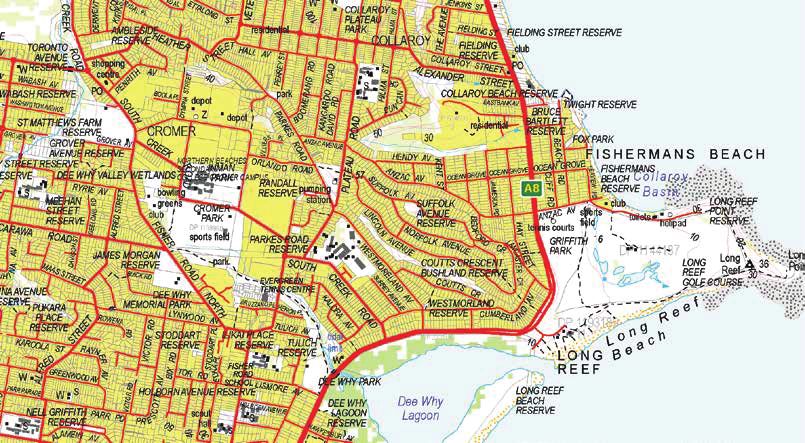
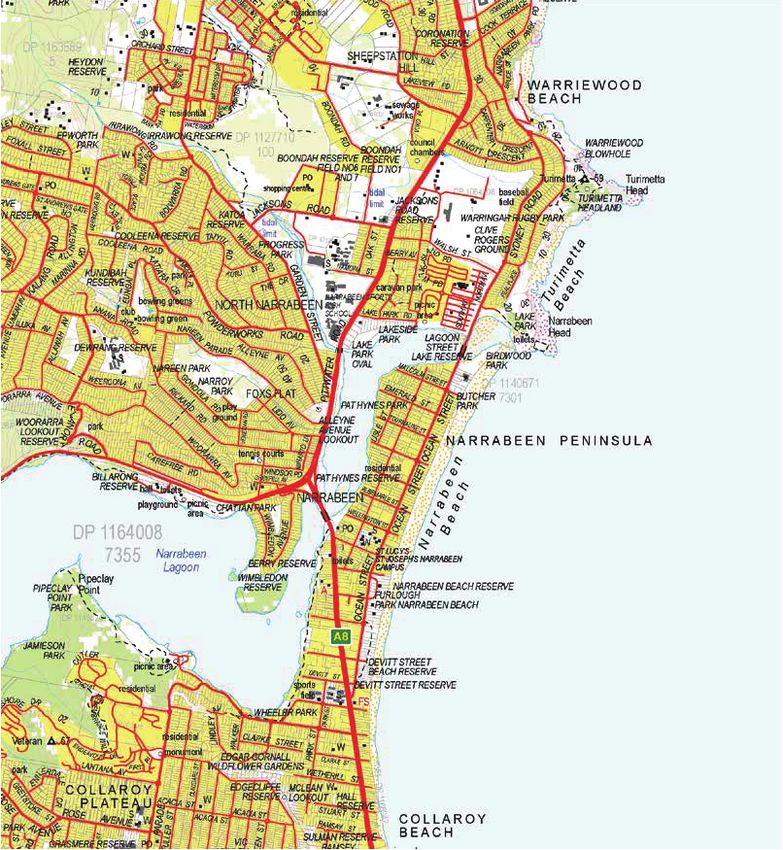
Palm Beach 60km start to Mona Vale
   Map 1 of 2

             KEY
           Route

           Next/Previous Section

           Start

           Luv Stop

           Public Toilets

           Road Crossing
                                            1

Source: Department
Source: Department Customer
                   Customer Services
                            Services 2019
                                     2019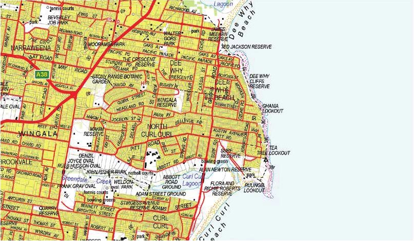
SYDNEY COASTREK 60KM
Palm Beach 60km start to Mona Vale Map 1 of 2
                                   Cumulative distance                           Must depart Newport
    Distance
                                      60km event                                     Luv Stop by

     +
     - 15km                                     +                                            11am
                                                - 15km

    114

    75
    50
    25
     3
         0             2.5                 5               7.5          10.6
                                   Distance (kilometres)

•        60km event starts here!
•        Start on beach just north of Palm Beach Surf Life Saving Club (SLSC) off Beach Road, Governor Phillip
         Park.
•        Head north on Palm Beach and turn LEFT at the last beach exit. Walk along the bush track to the Pittwa-
         ter side of the peninsula and turn RIGHT.
•        After 60m along the sand, turn RIGHT before the house at 1199 Barrenjoey Rd. As you past the house
         on your left, follow the trail LEFT behind the house. Before you hit the Barrenjoey track, you’ll see a set
         of stairs on your RIGHT. Take the stairs.
•        Follow the stair track all the way up to the Lighthouse and take in the spectacular views!
•        Turn LEFT in front of 1199C Barrenjoey Rd, and join the Barrenjoey Track to head back down towards
         the beach. Follow the Barrenjoey track back down towards the beach. Turn RIGHT just before the house
         at 1199 Barrenjoey Rd. Follow the coast south on Fishermans Track, along the sand.
•        When you get to the Boat House Café, turn LEFT towards the carpark. Cross the road in front of the
         Boat House to Governor Phillip Park and turn RIGHT.
•        Follow the grassy track between the trees until you get to Beach Rd. Before Beach Rd, turn LEFT
         towards Palm Beach.
•        Stay on beach to southern end. Keep off Ocean Road as buses/vehicles travel quickly and there are
         blind corners, so you may not be seen.
•        Go to southern end of Palm Beach and ascend the steps above the rock pools.
•        When you reach Florida Road, go RIGHT for 20m, then turn LEFT at house driveway. Go up driveway for
         50m and veer LEFT into smaller driveway (1A Rockridge), then up this veering LEFT to access a bush
         track (Public Land sign). Follow the track to Rock Bath Road.
•        Go along Rock Bath Road then turn LEFT into Pacific Road (Caution! No signpost or footpath!), then
         LEFT into Norma Road followed by RIGHT onto Whale Beach Road.
•        Follow Whale Beach Road for almost 300m, then go LEFT down Public Pathway steps (opposite house
         number 242).
•        Go RIGHT along Whale Beach (please keep off the dune vegetation).
•        At south end of the beach, go up onto the pathway, past toilets and then RIGHT upstairs to Malo Road.
•        Turn RIGHT at Malo Road, then LEFT into Whale Beach Road, keeping to the footpath.
•        Follow Whale Beach Road past Hal Baily Reserve and Careel Head.

                                                                                                                       2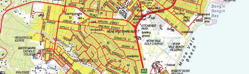
Palm Beach 60km start to Mona Vale
  MAP 2 OF 2

           KEY
         Route

         Next/Previous Section

         Luv Stop

         Public Toilets

         Road Crossing
                                            3
Source: Department Customer Services 2019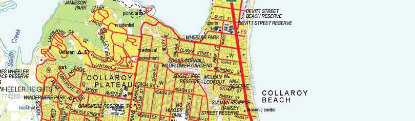
SYDNEY COASTREK 60KM
Palm Beach 60km start to Mona Vale, Map 2 of 2
                                      Cumulative distance                                  Must depart Newport
 Distance
                                         60km event                                            Luv Stop by

              15km                                    +
                                                      - 15km                                      11am

     66
     50
     40
     30
     20
     10
      1
          0    0.75   1.5    2.25     3        3.75         4.5   5.25   6   6.75   7.56
                                    Distance (kilometres)

 •            Turn LEFT into bush track to Bangalley Head Reserve (opposite house number 60).
 •            Follow main track up to top of headland. Here there is a vague track intersection (alongside a rock
              outcrop on LEFT and a sign that reads ‘Loop Trail’ on its southern side). Take LEFT fork of track up over
              rock outcrop past wooden marker-post to the very edge of the cliff-top (Caution! No guard-rail!). This is
              Blue Tongue Lookout, with incredible views north to Barrenjoey.
 •            Turn RIGHT at cliff edge and continue south along cliff edge track to next track junction.
 •            Here, turn sharp LEFT into track descending down south side of Bangalley Head. Follow track down to
              open grassy area at edge of North Avalon cliff line.
 •            At south end of grassy area, enter bush path that veers RIGHT towards Marine Parade.
 •            Turn LEFT onto Marine Parade.
 •            Follow Marine Parade to T-junction and turn LEFT into Avalon Beach Carpark. Walk down onto beach
              and continue to walk towards the grass reserve at south end of beach.
 •            Continue LEFT onto Avalon Parade, which eventually becomes Surfside Ave. Follow it until it becomes a
              dead end, then take path between houses numbered 4 & 5 to Barrenjoey Rd.
 •            Turn LEFT and follow track behind barrier rail and then grassy verge for about 100m. Turn LEFT onto
              The Serpentine. Continue along this around Bilgola Head. (Caution! NO footpath on The Serpentine
              for some sections.)
 •            Just beyond where The Serpentine runs parallel to Barrenjoey Rd, descend wooden stairs on LEFT
              leading down to Bilgola Beach.
 •            Follow path down to beach and walk across sand to car park on northern side of Bilgola SLSC (toilets
              to R). Go up wooden stairs to west (note: signed as Bilgola South Head).
 •            Veer LEFT into bush track that leads around headland and down to Newport Beach. Go straight ahead
              to walk along the sand at Newport beach.
 •            Exit Newport beach at Bert Payne Park and you have reached your first Luv Stop!
 •            Grab a snack, refill your water and take a quick rest! When you’re leaving, make sure you cross the
              timing point as a team and that your bib is on your front!
 •            Depart the Luv Stop and walk along Myola Rd and follow it to the LEFT before crossing Bungan Head
              Rd to reach Myola Rd walking track.
 •            Follow the track toward Bungan Beach and take a LEFT down the steps and steep driveway to the
              sand.
 •            Walk along beach until halfway across Bungan Beach, then turn RIGHT into sand path between dunes.
 •            Sand path becomes steps; take steps and then steep ramp up (the ramp is marked as Beach Rd) to
              Barrenjoey Rd.
 •            Turn LEFT into Barrenjoey Rd (footpath) and follow until you can turn LEFT into Hillcrest Ave (Caution!
              No footpath!) and follow it to dead-end at Mona Vale Headland Reserve.
 •            Go straight ahead and around the headland bus track, until you reach a signposted bush track
              towards Basin Beach.
 •            Track goes to RIGHT at bottom of descent into a wide grassy path and onto Basin Beach.
 •            Follow Basin Beach around to Mona Vale Beach.
 •            Walk along Mona Vale Beach and stay on the sand to the South end. Turn RIGHT upstairs to Robert
              Dunn Reserve.
                                                                                                                          4
Mona Vale to South Curl Curl
     MAP 1 OF 2

              KEY
            Route

            Next/Previous Section

            Luv Stop

            Public Toilets

            Road Crossing
                                            5
Source: Department Customer Services 2019
SYDNEY COASTREK 60KM
Mona Vale to South Curl Curl Map 1 of 2
                                    Cumulative distance                             Must depart Long Reef
    Distance
                                       60km event                                        Luv Stop by

    +
    - 15km                                           +                                    3.30pm
                                                     - 30km

    40
    30
    22
    15
     7
     0

         0   0.5   1   1.5   2        2.5        3       3.5   4   4.5   5   5.36
                                 Distance (kilometres)

•    Follow the pathway along until you can turn LEFT and join Narrabeen Park Parade. (Caution! No footpath!)
•    Continue south along Narrabeen Park Parade, and then go LEFT at round blue sign (opposite house
     number 156) downstairs to Warriewood Beach.
•    Once on beach, walk all the way to the southern end.
•    When alongside the Warriewood SLSC leave the beachfront and ascend a grassy bank to the far (eastern)
     corner of the clubhouse.
•    Follow Warriewood walking track past the lookout, through Warriewood Park and towards Turimetta Head
     lookout.
•    On way up to Turimetta Head the track exits into a small grassy clearing. Stay to the left and follow track
     out to the eastern-most point.
•    Continue along trail until summit of Turimetta Head to track junction.
•    Take the LEFT (eastern-most) track and follow this past a wooden lookout on the left-hand-side. Continue
     down track and then LEFT downstairs to Turimetta Beach.
•    On beach, turn RIGHT and walk across sand towards Narrabeen Head.
•    Near south end of Turimetta Beach, turn RIGHT. Take the sandstone steps and track up. Turn LEFT and go
     around Narrabeen Head Aquatic Reserve.
•    At the south end of the headland, take the left-hand-side track down to North Narrabeen Headland look-
     out. Turn RIGHT along the track and then LEFT towards the carpark. Walk around South Creek and onto
     Ocean St.
•    Cross Narrabeen Lagoon via bridge. Once across lagoon mouth, turn LEFT into track that leads to North
     Narrabeen SLSC. Turn LEFT past the SLSC and onto Narrabeen Beach.
•    Walk along the sand down Narrabeen Beach all the way South to Collaroy Beach.

                                                                                                                   6
Mona Vale to South Curl Curl
  MAP 2 OF 2

                                            30KM START

           KEY
         Route

         Next/Previous Section

         Luv Stop

         Public Toilets

         Road Crossing
                                                         7
Source: Department Customer Services 2019
SYDNEY COASTREK 60KM & 30KM
Mona Vale to South Curl Curl Map 2 of 2
Cumulative distance Must depart Long Reef
Distance
60km event Luv Stop by
+
- 15km + 3.30pm
- 30km
33
25
20
15
10
5
0
0 0.75 1.5 2.25 3 3.75 4.5 5.25 6 6.75 7.79
Distance (kilometres)
• At south end of Collaroy Beach take the steps just before the rock pool and head up to Stanley and
Florence Twight Reserve.
• Continue via grassy verge immediately east of houses and continue to stairs descending to Fisherman’s
Beach/The Basin.
• Continue along Fisherman’s Beach and past the Long Reef Golf Course clubhouse. Follow footpath and
grassy verge to the east to end of Long Reef Headland access road. Continue past boom gate onto wide
track around Long Reef Headland.
• The track begins to curve through bushes. At the next track intersection take the LEFT fork to Long Reef
SLSC.
• You’ve hit the halfway mark!!
• Grab a snack, refill your water and take a quick rest! When you’re leaving, make sure you cross the timing
strip as a team and that your bib is on your front!
• The 30km event starts here!
• From the SLSC continue onto Long Reef Beach via access way turn RIGHT & go past Dee Why Lagoon
onto Dee Why Beach.
• Continue on sand to southern end of Dee Why Beach. When you reach the staircase near the play-
ground, walk up and join the footpath.
• Continue past public toilets beside rock baths. Go up stairs here on RIGHT to footpath around car park.
• Veer LEFT into bush ‘Bicentennial’ track around headland keeping to track around the outer edge. Veer
RIGHT on track at Dee Why Head and go down to North Curl Curl Beach and mouth of Curl Curl Lagoon.
• Walk along the sand towards the South end.
8South Curl Curl to Balgowlah
15KM START
KEY
Route
Next/Previous Section
Luv Stop
Public Toilets
Road Crossing
9
Source: Department Customer Services 2019SYDNEY COASTREK 60KM & 30KM
South Curl Curl to Balgowlah
Cumulative distance Must depart Balgowlah
Distance
60km event 30km event Luv Stop by
+
- 15km + + 8pm
- 45km - 15km
98
75
50
25
0
0 1 2 3 4 5 6 7 8 9 10 11 12 13 14 14.8
Distance (kilometres)
• At the southern end of South Curl Curl beach go up the small set of steps into the car park, then take the stairs up
between the public toilets and rock baths and follow boardwalk.
• Turn LEFT into Lumsdaine Drive and after 100m turn LEFT again into McKillop Park car park.
• Follow footpath to toilet block to Freshwater Beach, cross beach to far end and turn RIGHT onto windy track/stairs
up to Bridge Rd.
• Continue straight ahead for 50m on road over top of headland past Pavilion Reserve, then take stairs down to
Greycliffe St; and continue on Bridge Rd, over the Manly Creek bridge.
• Veer LEFT in front of Queenscliff SLSC and walk along esplanade to Manly Beach SLSC, then continue onto Marine
Pde past Fairy Bower rock baths to Shelly Beach.
• Walk past The Boathouse café and up the stairs straight ahead to Bower St car park. Cross to top end of car park
and enter bush track leading up to North Head. Follow winding bush track.
• Cross Bluefish Dr to the follow the track to the RIGHT with Bluefish Dr to your right. At the Darley Rd fork, take a
sharp LEFT onto N Head Scenic Dr footpath.
• After 200m, carefully cross N Head Scenic drive and walk down Collins Beach Rd. (CAUTION! No Footpath on
Collins Beach Rd!).
• Go down Collins Beach Rd to car park before Australian Institute of Police Management.
• Turn RIGHT into bush track to Collins Beach. Cross beach and then locate stairs to bush track leading up to Stuart
St.
• Turn RIGHT onto Stuart St, follow road until turning RIGHT onto East Esplanade. Veer LEFT down ramp through
East Esplanade Reserve, then continue along footpath past Manly Wharf area.
• From Manly Wharf follow the Fairlight Walk past Fairlight Beach to the far end of Esplanade Park. Keep going past
Manly Boatshed and until you reach Lauderdale Ave – turn L here.
• Walk 50m along Lauderdale Ave, and then turn L into King Ave. Follow this around and then turn LEFT continuing
onto North Harbour Reserve.
• You have reached the Balgowlah Luv Stop!
10Balgowlah to Mosman Finish
15KM START
1
TO GO
4
TO GO
KEY 3
TO GO
Route 2
TO GO
Next/Previous Section
Finish
Luv Stop
Public Toilets
Road Crossing 11
Source: Department Customer Services 2019SYDNEY COASTREK 60KM, 30KM & 15KM
Balgowlah Luv Stop/15km start to Mosman Finish
Cumulative distance
Distance Finish closing time
60km event 30km event 15km event
+ +
- 60km +
- 30km +
- 15km - 15km 12.30am (Sat 28 March)
89
75
50
25
0
1 2 3 4 5 6 7 8 9 10 11 12 13 14.5
Distance (kilometres)
• The 15km event starts here!
• Depart North Harbour Reserve and follow track at water’s edge above oyster-covered rocks.
• Take the stairs up to RIGHT and then turn LEFT into North Harbour St. Follow road until a LEFT turn into Clarence
St, then turn LEFT towards North Harbour Walk.
• Go through yellow boom gate and follow wide bitumen track to Forty Baskets Beach. Stay on track and continue
along past Reef Beach.
• Follow track slightly R and uphill to Dobroyd Head – make sure to follow the “The Spit” signage at every junction.
• Traverse beneath Dobroyd Head Scenic Drive car park/Crater Cove lookout.
• Continue to T-junction 30m above Castle Rock Beach. Go RIGHT up concrete steps/creamy- yellow handrail for 25m
then LEFT following blue MSW signs to The Spit. Continue to Clontarf Reserve following bush track beneath houses.
• The track will end and the last section to Clontarf Reserve is on sand. Take the Monash Crescent detour if the tide is
high.
• Walk through the reserve, turn LEFT onto Sandy Bay Rd and then onto the pathway after Clontarf Marina.
• Follow the footpath at Sandy Bay and walk through the carpark and follow Fisher Bay Walk all the way around to
the Spit Bridge.
• Cross bridge, follow along Spit Rd and turn LEFT into Parriwi Rd.
• Go up Parriwi Rd and just before the bus-stop (after house #41) turn sharply LEFT down the steps into Cyprian St
and cross to footpath on South side of road.
• Follow road to RIGHT as it becomes McLean Cres to meet Rosherville Reserve.
• Cut across the Reserve and continue up the path and ramp on Rosherville Rd to Hopetoun Ave.
• Turn LEFT at Hopetoun Ave and follow road around as it becomes Burran Ave.
• Follow along Burran Ave until Stanton Rd – go to the end of this road and then onto the bush track. Follow track
down to Balmoral Beach.
• Walk south along the sand until you reach Balmoral Beach Esplanade.
• Continue along the Esplanade to south end of beach, past Balmoral Baths, onto grassy foreshore area near
Balmoral Sailing Club.
• Cut across Balmoral Oval onto bush track. Follow this to the LEFT and up that stairs that lead to Middle Head Rd.
• Turn LEFT just before Middle Head Rd through the bush. At Middle head Rd, follow the road RIGHT to Suakin Drive
and turn LEFT.
• Take a RIGHT down Dominion Cres with Georges Heights Oval on your right. At the cul-de-sac, enter the bush path
and turn LEFT.
• Follow the bush path down to Chowder Bay Rd and turn LEFT. Take a quick LEFT turn back onto another bush path
adjacent to the Drift Café.
• Follow the path through Headland Park and alongside Middle Head Rd. At Middle Head Rd, turn RIGHT and follow
the road on the footpath to the Y-Junction. Veer LEFT onto Govenors Road.
• Just after the newly built Middle Head Officier’s Quarters, on your left, veer LEFT off Govenors Road onto the secret
bush path.
• Follow the narrow bush path towards the Inner Middle Head battery and continue RIGHT.
• Emerge from the bush to the Finish! YOU DID IT! 12SYDNEY EVENT MAP BOOK WALKING FOR MENTAL HEALTH
You can also read