Sensitivity analysis of a simplified precipitation-runoff model to estimate water availability in Southern Portuguese watersheds Analisi di ...
←
→
Page content transcription
If your browser does not render page correctly, please read the page content below

DOI 10.7343/as-2021-514 2021-AS37-514: 33 - 47
journal homepage: https://www.acquesotterranee.net/
Sensitivity analysis of a simplified precipitation-runoff model to estimate water
availability in Southern Portuguese watersheds
Analisi di sensitività di un modello semplificato di precipitazione-deflusso per stimare la
disponibilità di acqua nei bacini idrici del Portogallo meridionale
Tiago N. Martinsa , Manuel M. Oliveiraa, Maria M. Portelab , Teresa E. Leitãoa
aHydraulics and Environment Department, National Laboratory for Civil Engineering, Lisbon, Portugal - email: tmartins@lnec.pt;
moliveira@lnec.pt; tleitao@lnec.pt
bTechnical University of Lisbon | UTL · Department of Civil Engineering and Architecture (DECivil) email: maria.manuela.portela@tecnico.ulisboa.pt
Riassunto
article info La stima della disponibilità idrica nelle grandi regioni è una procedura importante nella
Ricevuto/Received: 03 May 2021 definizione di una politica di gestione delle risorse idriche ad ampio spettro, ma può rivelarsi
Accettato/Accepted: 25 June 2021
Pubblicato online/Published online:
difficile a causa della mancanza di dati e dell’incertezza sulla relativa caratterizzazione idrologica
30 June 2021 ed idrogeologica regionale. BALSEQ, un modello di bilancio idrico sequenziale giornaliero,
Editor: Matteo Cultrera è stato implementato in una serie di ventidue bacini idrografici nel sud del Portogallo, con
l’obiettivo di comprendere le possibili relazioni tra i parametri del modello e le caratteristiche
dei bacini idrografici che possono consentire l’assemblaggio di funzioni di calibrazione per quei
bacini idrografici che non sono monitorati. È stata condotta un’analisi di sensitività confrontando
i risultati di BALSEQ con il deflusso superficiale misurato, concentrandosi in particolare sulla
Citation: frazione della potenziale ritenzione massima (φ) e la quantità massima di acqua disponibile
Tiago N. Martins, Manuel M.
Oliveira, Maria M. Portela , Teresa nel suolo per i parametri di evapotraspirazione (AGUT) e il modello concettuale idrogeologico
E. Leitão (2021) Sensitivity analysis sottostante che controlla infine le interazioni tra superficie e falda.
of a simplified precipitation-runoff I risultati complessivi non hanno permesso di identificare relazioni chiare che consentano
model to estimate water availability
l’estrapolazione ad altre regioni prive di dati, in quanto le procedure di analisi di sensitività
in Southern Portuguese watersheds.
Acque Sotterranee - Italian Journal of hanno restituito risultati simili per ampi intervalli di parametri per la maggior parte dei
Groundwater, 10(2), 33 - 47 bacini idrografici. I risultati hanno confermato che il contributo delle acque sotterranee è una
https://doi.org/10.7343/as-2021-514 componente importante per il deflusso superficiale complessivo misurato e che il parametro φ
Correspondence to: non deve essere trascurato nel calcolo del ruscellamento superficiale. Sono stati osservati scarsi
Tiago N. Martins : aggiustamenti complessivi tra i risultati del modello e il flusso misurato in bacini idrografici con
tmartins@lnec.pt un basso rapporto flusso superficiale - precipitazioni.
Abstract
The water availability estimation in large regions is a relevant procedure to define broad water resources
management policies but may prove difficult due to the lack of data and uncertainty to related regional
Keywords: surface runoff, aquifer
recharge, hydrological modelling, daily hydrological and hydrogeological characterization. BALSEQ, a daily sequential water budget model, was
sequential soil-water budget, BALSEQ. applied in a set of twenty-two watersheds in southern Portugal, aiming to understand the possible relations
between the model parameters and watershed characteristics that may allow assembling calibration functions
Parole chiave: ruscellamento for non-monitored watersheds. A sensitivity analysis was conducted by comparing BALSEQ results with
superficiale, ricarica della falda, measured surface flow, focusing specifically on the fraction of the potential maximum retention (φ) and
modellazione idrologica, bilancio the maximum amount of water available in the soil for evapotranspiration (AGUT) parameters and the
sequenziale giornaliero suolo-acqua,
underlying hydrogeological conceptual model that ultimately controls the surface-groundwater interactions.
BALSEQ.
The overall results did not allow to identify clear relations that permit extrapolation to other regions
without data as the sensitivity analysis procedures returned similar results for wide intervals of parameters
Copyright: © 2021 by the authors.
Licensee Associazione Acque Sotterranee. for the majority of watersheds. The results confirmed that the groundwater discharge is an important
This is an open access article component for the total measured surface flow and that the φ parameter should not be overlooked when
under the CC BY-NC-ND license: calculating direct runoff. Poor adjustments between the model results and measured flow were observed in
http://creativecommons.org/licenses/by-
watersheds with a low Surface flow – Rainfall ratio.
nc-nd/4.0/
33
DOI 10.7343/as-2021-514 Acque Sotterranee - Italian Journal of Groundwater 2021-AS37-514: 33 - 47
Inroduction south coastline. Water scarcity phenomena connected to
The characterisation of surface runoff and aquifer seasonal tourism and agricultural pressures require a robust
recharge is a fundamental procedure in water resources and integrated and effective management of water resources
watershed management (Sophocleous 2002). Being surface (Portuguese Environmental Agency (APA) 2020). On the
water availability one of the main factors for the successful opposite way, the region is also prone to flash flood events
implementation of alternative water management techniques (Ramos and Reis 2002), related to the low permeability rocks,
such as managed aquifer recharge (MAR) (Dillon et al. coupled with intense and time-concentrated rainfall episodes.
2009; Maliva 2014; Page et al. 2018; Alam et al. 2021), daily Figure 1 shows the study area and the selected set of 22
characterization of the behaviour of different hydrological watersheds, numbered from north to south. The selection of
components may be of relevance for watershed management, watersheds relied on the availability of surface flow data and
including the definition of solutions to mitigate the effects of that no surface water reservoirs existed when the river flow
extreme events, such as floods, while increasing groundwater measurements were conducted (watersheds under natural
storage. The precise recharge calculation is also an essential conditions).
process to characterize and manage the exploitable volume of
groundwater (Oliveira, 2006). Objectives and Methods
For this kind of characterization in large regions, where Sequential water budget model description
lack of data is common, the use of simplified surface-runoff The model used, BALSEQ, was developed by Lobo
models may be an acceptable solution as they require fewer Ferreira (1981). It is one of the several daily sequential water
input data if compared to large datasets essential in more budget models and has been widely applied, mainly for the
complex models (Jeon et al. 2014). The Soil Conservation evaluation of groundwater recharge, in Portugal in diverse
Service Curve Number (CN) based models consider the hydrogeological settings – from sedimentary basins (Oliveira
main watershed characteristics, such as soil type and land and Lobo Ferreira 1999; Leitão et al. 2001), to predominantly
use, while allowing the estimation of surface runoff from fractured lithologies (Oliveira et al. 1997) and volcanic regions
rainfall (USDA-NRCS 2004). Direct runoff is defined and (Novo et al. 1994) – but also in India (Chachadi et al. 2001;
may be relevant in the calibration of other parameters such as Chachadi et al. 2005) and Brazil (Leitão et al. 2017; Costa et
the initial abstractions relation (Ia = φS, being Ia the initial al. 2019).
abstraction, S the maximum potential retention, and φ a One of BALSEQs’ main advantages is that it estimates
fraction of S). Although φ is often set equal to 0.2 (USDA a set of hydrological components using information that is
NRCS 2004), several authors suggest that it varies from usually easily available. BALSEQ inputs are daily rainfall (P),
location to location (Ling et al. 2019) and that such value may potential evapotranspiration (PET), Soil Conservation Service
not be adequate for certain regions (Portela et al. 2000) as it Curve Number (CN) and the maximum amount of water
tends to overestimate the initial rainfall losses or abstractions. available in the soil for evapotranspiration (AGUT). The main
This suggests that the calibration of that parameter can be outputs are direct runoff (Ed) and soil deep infiltration (Ip).
of relevance when applying CN based models. For Portugal Considering a soil control volume, the model assumes that
mainland, Correia (1984) concluded that the assumption of inflow water is exclusively due to the infiltration, given by
φ = 0.2 was not verified, suggesting that it could be lower. rainfall minus direct runoff. The flow is purely vertical. Side
The main objective of this study, which is part of a outflow from the control volume and surface water extraction
broader work to characterise water availability, is to evaluate are not considered. Variables related to water fluxes are
the sensitivity of a simplified precipitation-runoff model expressed in mm. It uses the Soil Conservation Service (SCS)
and explore possible relations between intrinsic watershed formulation to calculate direct runoff (Ed), based on the CN
characteristics and the evaluated input parameters to define parameter (USDA-NRCS 2004), according to the following
calibration functions for similar ungauged watersheds. equations:
Study area (P − I )
2
Ed = a
The study area is the southern region of Portugal, ( P − I ) + S (1)
a
characterised by high seasonal variability of rainfall (Trigo
and DaCamara 2000; Durão et al. 2010; Gassert et al. 2015) 1000 1000
=
CN ⇔=
S − 10 ⋅ 25.4
and prone to extended periods of drought (Santos et al. 10 +
S CN
2010), which are expected to become increasingly recurrent 25.4 (2)
(Oliveira 2007). The region includes two of the most
important Portuguese river basins, Guadiana and Sado, with I a = ϕ S (3)
the presence of major surface water storage infrastructures on
which most economic activities depend. where Ia are the initial abstractions (mm), S is the potential
The area is mainly composed of low permeability maximum retention (mm) and φ is the fraction of S, defined
metamorphic and eruptive rocks (77%) with permeable as 0.2 based on the study by the SCS of a set of watersheds in
sedimentary and karstic formations mainly located near the the USA. By combining equations (2) and (3) and introducing
34
Acque Sotterranee - Italian Journal of Groundwater 2021-AS37-514: 33 - 47 DOI 10.7343/as-2021-514
Fig. 1 - Study area, schematic representation of the studied watersheds and numbering and identification of the corresponding river gauge stations.
Fig. 1 - Area di studio, rappresentazione schematica dei bacini idrografici studiati e numerazione e identificazione delle corrispondenti stazioni di sagoma fluviale.
the result achieved in equation (1) it is possible to address the be the most adequate approach for the studied area given it
variation of the generated direct runoff as a function of φ, as often experiences long dry periods followed by intense rain
expressed by equation (4): episodes – the model was adjusted to consider dry (CNI)
2
and wet (CNIII) antecedent conditions (Chow et al. 1988) –
P 1000ϕ
25.4 − + 10ϕ equation (6) and (7).
25.4 CN
Ed =
P 1000 − 1000ϕ CN = 4.2CN II (6)
(4) + − 10 + 10ϕ I
10 − 0.058CN II
25.4 CN
As φ increases Ia will also increase resulting in a decrease of 23CN
CN III = 10 + 0.13CN
II
Ed. Figure 2 shows the theoretical behaviour of the computed (7)
Ed for different rainfall values and φ for CN = 80. II
The formulation for Ed given by equation (4) was included
in the BALSEQ model (Fig. 3), replacing the original formula
defined by SCS. The daily deep infiltration (Ip) is calculated
by equation (5):
I p= P − Ed − AET − ∆Al (5)
where AET is the actual evapotranspiration and ΔAl is the
variation of water within the control volume during each day.
The difference between P and Ed corresponds to the Is (surface
infiltration), the amount of water that enters the soil control Fig. 2 - General variation of computed Ed by changing rainfall and φ.
volume. Given that CN values are extracted for regular Fig. 2 - Variazione complessiva del Ed calcolato a seconda delle variazioni delle
antecedent moisture conditions (AMC II) – which may not precipitazioni e di φ.
35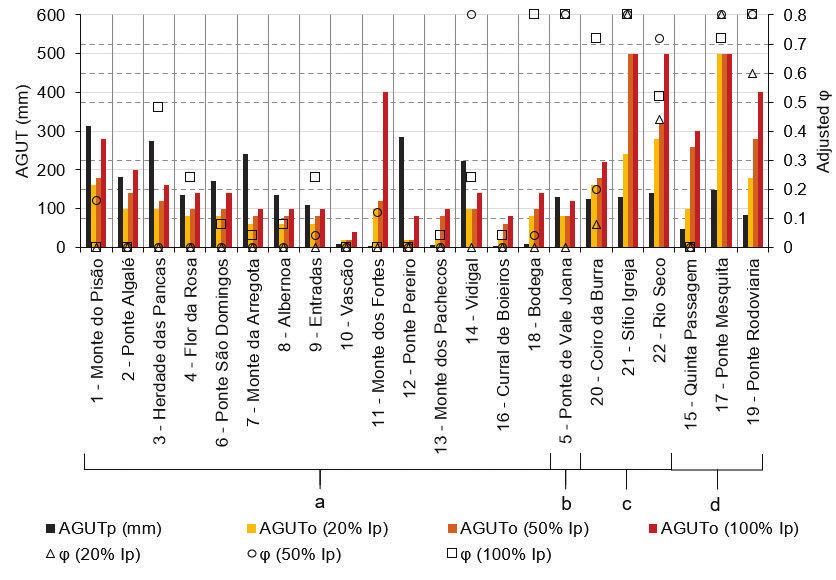
DOI 10.7343/as-2021-514                                                   Acque Sotterranee - Italian Journal of Groundwater 2021-AS37-514: 33 - 47

                                          Fig. 3 - Approach implemented in adapted BALSEQ model.
                                         Fig. 3 - Approccio implementato nel modello BALSEQ.

   Figure 4 shows the behaviour of BALSEQs’ main outputs
– direct runoff, Ed, and deep infiltration, Ip – for different
values of AGUT and φ, using rainfall, evapotranspiration, and
CN for the watershed of 9 – Entradas. For the same rainfall
episode, if φ is increased, the Ed decreases (Fig. 2) while the
amount of water that enters the control volume increases.
Since the AGUT parameter controls the amount of water that
is retained in the soil, higher AGUT results in the decrease of
the amount of water that exits the control volume to recharge
the aquifer (Ip).                                                     Fig. 4 - Variation of Ed and Ip BALSEQ components for different inputs.
   The model was implemented in a Python 3 script and run             Fig. 4 - Variazione celle componenti BALSEQ Ed ed Ip.
at a daily scale starting at the beginning of each hydrological
year – October 1st – assuming that Al = 0.

36
Acque Sotterranee - Italian Journal of Groundwater 2021-AS37-514: 33 - 47                                                             DOI 10.7343/as-2021-514

Preparation of input data and hydrogeological models                        water will flow in the saturated zone and sometimes discharge
   The daily rainfall dataset was assembled from rainfall series            to the surface. For the studied watersheds, this discharge may
collected and published by the Portuguese National Water                    occur almost completely inside the watershed, in the case
Resources Information System (https://snirh.apambiente.pt/)                 of underlying less permeable formations (fractured massifs),
for 191 rain gauge stations within the study area. A sub-set                where x%Ip assumes a value close to 100, or, in the case of
of stations was selected for each watershed, using proximity                more permeable watersheds, may discharge outside the
criteria, from which average rainfall series was computed                   watershed limit, x%Ip is closer to 0.
using Inverse Distance Weighting (IDW) based on a 1 km
cell-sized grid. The average PET series was generated using
the Thiessen polygons method from a dataset assembled
from data made available by regional agricultural authorities
and the Portuguese Environmental Agency (Supplementary
Materials, Tab. 5). The daily values of surface flow (SF) were
extracted from the Portuguese National Water Resources
Information System for each of the 22 selected watersheds.
   The extension of assembled meteorological input series
varied from 4 to 24 hydrological years depending on the
length of surface flow (SF) dataset. Table 1 summarizes the
studied watersheds characteristics, average meteorological
data and SF, as well as a SF-Rainfall ratio. The stations used
for generating rainfall, PET and SF series for each watershed
are presented in Supplementary Materials (Tab. 6 to Tab. 13).
   AGUT is computed based on three different parameters
– soil field capacity (fc), wilting point (wp) and root depth
(Rd) – associated with the soil use/occupation mapped
by CORINE Land Cover Inventory (CLC, in https://land.
copernicus.eu/pan-european/corine-land-cover) and soil type
maps. Root depth, even in annual average terms, is, e.g.,
highly dependent not only on the vegetation type but also
on pedologic or geologic characteristics; moreover, it changes
seasonally with the vegetation natural cycles. It is, therefore,
a parameter highly susceptible to calibration. Vermeulen et
al. (1993), Oliveira et al. (1997) and Oliveira (2004/2006)
established fc, wp and Rd for different types of soil and land
use. An adaptation of Rd was conducted to adjust Rd to
Lithosols (100 mm), in line with the pedologic characteristics
of the study area.
   CN was calculated based on the maps generated for
southern Portugal presented in Martins et al. (2021), from
which the soil and land use dataset was adopted to calculate
AGUT. These maps resulted from the implementation of the
method presented by Vermeulen et al. (1993) and adapted
by Oliveira et al. (1997) and Oliveira (2004/2006), which
assigned the CN value considering: (1) the soil type derived
from the Portuguese soil classification maps and (2) the
land-use description based on CLC. Spatial weighted AGUT
(AGUTp) and CN (CNp), were calculated for each watershed
(Tab. 1), i.e., a single average value computed from all AGUTs
and CNs weighted by the area of occurrence.
   To consider the effect of the exchanges that occur between
surface and subsurface, simulations were conducted assuming
different contributions of the deep infiltration, Ip, to the total
computed flow (Etotal = Ed + x%Ip, being x a percentage of                  Fig. 5 - Simplified schemes of watershed conceptual models under different hydrogeological
Ip) considering different conceptual models (CM) based on                   constraints.
hydrogeological characteristics (Fig. 5). After the recharge                Fig. 5 - Schemi semplificati di modelli concettuali di spartiacque in base a
                                                                            vincoli idrogeologici differenti.
process, calculated with BALSEQ, it is assumed that the

                                                                                                                                                               37
DOI 10.7343/as-2021-514                                                                  Acque Sotterranee - Italian Journal of Groundwater 2021-AS37-514: 33 - 47

                                                          Tab. 1 - BALSEQ input hydro-meteorological data.
                                                        Tab. 1 - Valori idrometereologici BALSEQ di input.

                                      Area              P              PET          SF           SF-R       Starting                                     AGUTp
          Watershed                                                                                                        # of years      CNp
                                     (km2)            (mm/y)          (mm/y)      (mm/y)         ratio        year                                        (mm)
 1 - Monte do Pisão                  227.5              812.7            1239.7    208.6         26%           1983            7            74.5          314.7 *
 2 - Ponte Algalé                     127.3             532.1            1100.7     74.7          14%          1985            9            68.0          182.8 *
 3 - Herdade das Pancas               57.1              672.6          1224.8       172.9        26%           1981            9            75.8          274.5 *
 4 - Flor da Rosa                    330.1              695.4          1222.6       199.4        29%           1941           24            75.2          134.9 *
 5 - Ponte de Vale Joana             180.0              532.8            1207.7     82.4          15%          2001            7            74.8         129.0 **
 6 - Ponte São Domingos              146.8              647.0            1297.7     164.3        25%           1982            7            75.6          170.6 *
 7 - Monte da Arregota                98.4              524.5          1299.7       96.6         18%           1981            9            81.0          240.6 *
 8 - Albernoa                         169.9             508.8          1296.1       108.5         21%          1970           21            83.7          136.1 *
 9 - Entradas                         51.2              530.1          1298.7       123.0        23%           1971           22            84.4          108.8 *
 10 - Vascão                         409.0              716.8          1464.2       350.1        49%           1960            14           78.1           8.1 *
 11 - Monte dos Fortes               283.2              839.2          1606.6       248.9        30%           1980            13           77.9           0.5 *
 12 - Ponte Pereiro                   50.0              718.3          1066.5      346.7         48%           2001            6            78.1         284.0 **
 13 - Monte dos Pachecos             394.2              752.0            1510.2    324.8         43%           1962            21           78.6            7.5 *
 14 - Vidigal                         18.8              663.9          1496.8       167.9        25%           1998            9            83.1          223.3 *
 15 - Quinta Passagem                100.5              708.3          1545.8       185.3        26%          2000             7            79.1          47.2 **
 16 - Curral de Boieiros              61.4              747.9          1546.7      256.2         34%           1984            11           77.7           3.4 *
 17 - Ponte Mesquita                  117.6             798.9            1559.8     34.5          4%           1984            6            83.6          147.0 *
 18 - Bodega                         133.2              744.8          1604.3       229.7         31%          1975            14           78.2           8.2 *
 19 - Ponte Rodoviaria               325.4              725.1            1524.0     90.4         12%           1980            14           80.5           82.5 *
 20 - Coiro da Burra                  35.8              834.3            1613.2     236.7        28%           1985            4            81.1          124.3 *
 21 - Sítio Igreja                    33.9              679.3            1612.9     36.9          5%           1996            9            81.3          130.2 *
 22 - Rio Seco                        63.5              728.0          1609.8       97.9          13%          1995            12           82.3          141.7 *
                                  P – rainfall (precipitazioni); PET – potential evapotranspiration (evaporazione potenziale); SF – surface flow (flusso superficiale);
                                  AGUTp – spatial weighted average AGUT (media spaziale ponderata di AGUT); CNp – spatial weighted average CN (media
                                  spaziale pondeata di CN); SF-R ratio – Surface Flow-Rainfall ratio (media flusso superficiale-pioggia)
                                  * AGUTp computed based in 1990 CORINE Land Cover Inventory version;
                                  ** AGUTp computed based in 2018 CORINE Land Cover Inventory version.

Sensitivity analysis procedures                                                      Five Ip percentages were used 0% (i.e., no deep infiltration),
  Two different simulation procedures were used for the                              20%, 50%, 80% and 100%, and 21 values of φ (from 0 to
evaluation of the model sensitivity based on the variation of                        0.8 with an increment of 0.04). The second procedure aimed
parameters (Tab. 2). The first procedure aimed to understand                         to understand the coupled impact of varying AGUT and
the impact of variation of φ using fixed spatial weighted                            φ using fixed CNp. This procedure only considered three
CN (CNp) and fixed spatial weighted AGUT (AGUTp),                                    different percentages of Ip: 20%, 50% and 100%. Sensitivity
with different x%Ip considered in the calculation of Etotal.                         to different CN was not studied as it is assumed that it is
                                                                                     supported by empirical data (Ponce et al. 1996).

                                                Tab. 2 - BALSEQ inputs considered in the sensitivity analysis conducted.
                                              Tab. 2 - Valori BALSEQ di input considerati per l’analisi di sensitività.

                                                                 Variables considered in simulations                            # of simulations conducted
 Sensitivity analysis designation
                                                 CN                  φ            AGUT (mm)                  x% Ip              for each watershed
 [1] Sensitivity of the parameters φ
                                                                                   AGUTp             0, 20, 50, 80, 100 *
 and percentage of Ip for fixed CNp                                                                                                              105
                                                                [0 – 0.8] *          [1]                      [5]
 and AGUTp                                       CNp
                                                                 Δ = 0.04
 [2] Sensitivity of the parameters                [1]                             [0 – 500] *
                                                                   [21]                                  20, 50, 100 *
 φ, percentage of Ip and AGUT for                                                   Δ = 20                                                      1575
                                                                                                              [3]
 fixed CNp                                                                            [25]
 Δ – Increments; * – parameters subject to variation in each simulation; [x] – number of elements

38
Acque Sotterranee - Italian Journal of Groundwater 2021-AS37-514: 33 - 47                                                          DOI 10.7343/as-2021-514

  The adjustment between computed surface flow (Etotal) and
measured surface flow (SF) was evaluated using the Nash-
Sutcliffe model efficiency coefficient, computed by equation (8):

                       ∑ (X                   − X isim )
                             n                             2
                                        obs

            NSE =   1−       i =1       i

                       ∑ (X                   − X imean ) 		 (8)
                            n                            2
                                    obs
                            i =1    i

   where n is the number of observations, Xiobs is the ith
observed/measured value, Xisim is the ith simulated/calculated
value and Xmean is the mean of the observed data. The                       Fig. 6 - Monthly (left) and yearly (right) computed Ed resulting from Avg. Ed and Avg
NSE ranges between ∞ and 1 (1 corresponds to the better                     CN computation methods. r is the coefficient of correlation.
adjustment and model performance). NSE
Acque Sotterranee - Italian Journal of Groundwater 2021-AS37-514: 33 - 47
Tab. 3 - Results of simulations with variable φ and fixed AGUTp and CNp.
Tab. 3 - Risultati delle simulazioni a seconda della variabile φ e con i valori di AGUTp e CNp imposti.
Ip contribution to total surface flow
Percentage of area Dom.
Watershed CM 0% 20% 50% 80% 100%
Geol.
E M K S Adj. φ NSEmax Adj. φ NSEmax Adj. φ NSEmax Adj. φ NSEmax Adj. φ NSEmax
01 - Monte Pisão 15% 83% 0% 2% M a 0.00 0.51 0.00 0.60 0.00 0.70 0.12 0.78 0.12 0.80
02 - Ponte Algalé 81% 19% 0% 0% E a 0.00 0.21 0.00 0.49 0.04 0.78 0.12 0.92 0.00 0.91
03 - Herdade das Pancas 12% 83% 0% 5% M a 0.00 0.34 0.00 0.40 0.00 0.48 0.00 0.55 0.04 0.58
04 - Flor da Rosa 62% 38% 0% 0% E+M a 0.00 0.31 0.00 0.49 0.00 0.70 0.08 0.85 0.12 0.89
05 - Ponte de Vale Joana 0% 78% 0% 22% M+S b 0.00 0.09 0.00 0.23 0.32 0.53 0.76 0.70 0.80 0.72
06 - Ponte São Domingos 0% 91% 0% 9% M a 0.00 0.44 0.00 0.54 0.00 0.66 0.08 0.76 0.12 0.81
07 - Monte da Arregota 11% 86% 0% 3% M a 0.00 0.34 0.00 0.40 0.00 0.48 0.00 0.55 0.00 0.58
08 - Albernoa 0% 96% 0% 4% M a 0.00 0.35 0.00 0.53 0.00 0.71 0.16 0.84 0.20 0.88
09 - Entradas 0% 100% 0% 0% M a 0.00 0.36 0.00 0.53 0.08 0.72 0.80 0.89 0.44 0.91
10 – Vascão 0% 100% 0% 0% M a 0.00 0.22 0.00 0.43 0.00 0.66 0.00 0.79 0.00 0.81
11 - Monte dos Fortes 0% 100% 0% 0% M a 0.00 0.83 0.04 0.87 0.64 0.86 0.80 0.52 0.16 -0.01
12 - Ponte Pereiro 10% 86% 0% 4% M a 0.00 -0.17 0.00 -0.17 0.00 -0.17 0.00 -0.16 0.00 -0.16
13 - Monte dos Pachecos 0% 100% 0% 0% M a 0.00 0.30 0.00 0.46 0.00 0.61 0.12 0.65 0.16 0.62
14 - Vidigal 2% 91% 2% 5% M a 0.00 0.05 0.00 0.07 0.00 0.09 0.00 0.10 0.00 0.11
15 - Quinta Passagem 5% 35% 22% 37% M+S+K d 0.00 0.39 0.00 0.43 0.60 0.43 0.80 -0.12 0.00 -0.89
16 - Curral de Boieiros 0% 100% 0% 0% M a 0.00 0.76 0.00 0.85 0.24 0.87 0.80 0.77 0.20 0.50
17 - Ponte Mesquita 2% 1% 40% 57% S+K d 0.80 0.38 0.80 -1.41 0.80 -10.82 0.80 -28.28 0.00 -38.90
18 - Bodega 0% 90% 0% 10% M a 0.00 0.56 0.00 0.64 0.20 0.67 0.80 0.58 0.56 0.34
19 - Ponte Rodoviária 3% 14% 26% 57% S+K d 0.24 0.41 0.80 0.55 0.80 0.37 0.80 -0.67 0.00 -1.59
20 - Coiro da Burra 0% 0% 12% 88% S c 0.00 0.59 0.00 0.64 0.08 0.69 0.04 0.73 0.00 0.75
21 - Sítio Igreja 0% 0% 10% 90% S c 0.80 0.01 0.80 -0.24 0.80 -4.31 0.80 -12.79 0.12 -20.22
22 - Rio Seco 0% 0% 13% 87% S c 0.24 0.38 0.76 0.55 0.80 0.44 0.80 -0.35 0.04 -1.04
Note: In red are overall computed NSE below zero (bad adjustment), while in black bold are represented the best results for that watershed (in rosso sono presentati gli NSE calcolati al di sotto di zero (adattamenti negativi),
mentre in grassetto nero sono rappresentati i migliori risultati per ciascun bacino).
DOI 10.7343/as-2021-514
E – Eruptive rocks (rocce effusive); M – Metamorphic rocks (rocce metamorfiche); S – Sedimentary rocks (rocce sedimentarie); K – Karstic areas (area carsica); Dom. Geol. – Dominant geology (geologia predominante);
CM – Conceptual model (modello concettuale)
a. Low permeability fractured rocks (rocce fratturate con bassa permeabilità) (Etotal = Ed + 100%Ip)
b. Low permeability fractured rocks with significant sedimentary influence (rocce fratturate con bassa permeabilità con influenza dal sistema sedimentario significativa) (Etotal = Ed + x%Ip)
c. Sedimentary with partial GW discharge outside watershed (Ricarica dal sistema sedimentario con parziale acque sotterranee al di fuori del bacin) (Etotal = Ed + 0%Ip)
d. Sedimentary with partial GW discharge inside watershed and significant karstic influence (Ricarica dal Sistema sedimentario con parziale portate di acque sotterranee all’interno del bacino ed una significativa influenza del
sistema carsico) (Etotal = x%Ip, with low x)
40
Adj, φ – Adjusted φ (adattato a φ); NSEmax – NSE related to adjusted φ (NSE riferito al valore adattato di φ).
Acque Sotterranee - Italian Journal of Groundwater 2021-AS37-514: 33 - 47                                              DOI 10.7343/as-2021-514

group, eleven watersheds resulted in adjusted φ < 0.2 and                   receives an important contribution from groundwater which
four with values varying between 0.2 and 0.44. In CM-b the                  is common in semi-arid areas and (2) reduce the number of
better adjustment was observed for maximum φ (0.8) and                      simulations to be conducted.
100%Ip.                                                                        Table 4 summarizes the results of the conducted simulations,
   In the three predominantly sedimentary watersheds (CM-                   presenting the pair of parameters (optimized AGUT –
c), 21 – Sítio Igreja showed better adjustment for 0%Ip,                    AGUTo – and adjusted φ) for each Ip that showed the best
22 – Rio Seco for 20%Ip and 20 – Coiro da Burra 80%Ip,                      adjustment considering the maximum computed NSE for
with adjusted φ varying from 0.04 (20 – Coiro da Burra) to                  the monthly data. Figure 8 compares the computed AGUTo
0.8 (21 – Sítio Igreja). It is not clear how to derive a specific Ip        with AGUTp by watershed and represents the distribution
for this group, from which the hydraulic heterogeneity of the               of the adjusted φ parameter. All results for the conducted
sedimentary rocks can result in different behaviour in terms                simulations, including spatial distribution, are presented in
of infiltration.                                                            the Supplementary Materials section (Fig. 20 to Fig. 33).
   For CM-d watersheds, 17 – Ponte Mesquita showed better                      The optimized AGUT (AGUTo) is generally lower for
adjustment for 0%Ip (φ = 0.8) and 15 – Quinta Passagem                      CM-a and CM-b when compared with CM-c and CM-b. For
(φ = 0) and 19 – Ponte Rodoviária (φ = 0.8) for 20%Ip.                      CM-a and CM-b the expected increase in AGUTo as a result
   12 – Ponte Pereiro (CM-a) showed NSE < 0 for all                         of increasing Ip is lower if compared with CM-c and CM-d.
simulations and 17 – Ponte Mesquita (CM-d) followed by 21                   This confirms the assumptions of the established conceptual
– Sítio Igreja (CM-c) showed the worst results for NSE (-38.9               models, considering that increased AGUTo results in lower Ip,
for 100% and -20.22 for 100%, respectively).                                which in predominantly sedimentary watersheds (CM-c) and
   Figure 7 compares average Etotal and Ed by measured surface              watersheds with a significant presence of karstic areas (CM-d)
flow, by watershed, for the more adequate percentages of Ip                 the discharge may occur outside the watershed bounds (hence,
given the established conceptual model (Tab. 3) – a = 100%Ip,               the lower contribution of the Ip in the Etotal). Considering the
b = 80%Ip, c = 0%Ip and d = 20%Ip. For all watersheds and                   model used, lower AGUTo means less water stored in the soil
particularly for CM-a it is possible to observe the increase of             and higher Ip. This is coherent with the assumption that in
r computed between Ed and Etotal confirming the importance                  watersheds with low permeability rocks (CM-a and CM-b),
of the Ip component to the total surface flow budget. That                  higher Ip is relevant in Etotal, even if a different percentage of
is similar to the CM-d group, in line with the established                  Ip may have to be considered if other rocks may influence the
assumptions of the conceptual model. It must be noted that                  infiltration. This is the case of CM-b (5 – Ponte de Vale Joana)
both CM-c and CM-d include a small number of watersheds                     which has >20% of the area composed of sedimentary rocks,
not allowing the extraction of relevant correlation.                        therefore the more adequate Ip may be lower than 100%.
   Adjusted φ was plotted against CNp, AGUTp and yearly                     Some exceptions are observed within the CM groups. CM-a,
average rainfall to evaluate possible relations that may allow              11 – Monte dos Fortes shows a relatively high AGUTo (400
extrapolating to other watersheds – Supplementary Materials,                mm) for 100% Ip. In CM-c, 20 – Coiro da Burra shows lower
Fig. 19a to Fig. 19c, respectively – and no relations were                  AGUTo for different Ip if compared with other watersheds
detected (r < 0.7).                                                         in the same group. This may be associated with increased
                                                                            average yearly rainfall and lower SF, having the higher SF-
Sensitivity of the parameters φ, percentage of Ip and                       Rainfall ratio in the group.
AGUT for fixed CNp                                                             In CM-d, 17 – Ponte Mesquita presents the better
  Concerning this sensitivity analysis, we opted to use three               adjustment for the highest AGUTo considered (500 mm),
percentages of Ip to (1) assume that at least 20% of the SF                 having the lowest SF-Rainfall ratio of the dataset. Concerning
corresponds to Ip, following the premise that baseflow                      CMs, in CM-a, for 100%Ip, the adjusted φ is lower than 0.24,

                                                                                                                   Fig. 7 - Computed Etotal (left) and
                                                                                                                   Ed (right) vs measured surface flow
                                                                                                                   (SF) for different Ip.
                                                                                                                   Fig. 7 - Valori calcolati
                                                                                                                   Etotal (sinistra) e Ed (destra)
                                                                                                                   confrontate con il flusso
                                                                                                                   superficiale misurato (SF) per
                                                                                                                   diversi valori di Ip.

                                                                                                                                                41
DOI 10.7343/as-2021-514                                                                            Acque Sotterranee - Italian Journal of Groundwater 2021-AS37-514: 33 - 47

                                                  Tab. 4 - Results of simulations with variable φ and AGUT and static CNp.
                                                Tab. 4 - Risultati delle simulazioni con φ variabile e AGUT e CNp statico.
                                                                                   20%Ip                                  50%Ip                                  100%Ip
              Watershed                      CM       AGUTp
                                                                     AGUTo         Adj. φ NSEmax            AGUTo         Adj. φ      NSEmax        AGUTo         Adj. φ      NSEmax
 1 - Monte do Pisão                            a        314.70          160         0.00         0.74          180         0.16         0.86           280         0.00           0.84
 2 - Ponte Algalé                              a       182.80           100         0.00         0.55          140         0.00         0.85           200         0.00           0.92
 3 - Herdade das Pancas                        a       274.50           100         0.00         0.57          120         0.00         0.79           160          0.48          0.93
 4 - Flor da Rosa                              a       134.90            80         0.00         0.52          100         0.00         0.74           140          0.24          0.89
 5 - Ponte de Vale Joana                       b       129.00            80         0.00         0.33          80          0.80         0.62           120         0.80           0.73
 6 - Ponte São Domingos                        a       170.60            80         0.00         0.62          100         0.00         0.78           140          0.08          0.86
 7 - Monte da Arregota                         a       240.60            60         0.00         0.56          80          0.00         0.77           100         0.04           0.84
 8 - Albernoa                                  a       136.10            60         0.00         0.6           80          0.00         0.82           100          0.08          0.94
 9 - Entradas                                  a       108.80            60         0.00         0.55          80          0.04         0.77           100          0.24          0.91
 10 - Vascão                                   a         8.10            20         0.00         0.41          20          0.00         0.64           40          0.00           0.83
 11 - Monte dos Fortes                         a         0.50           100         0.00          0.9          120         0.12         0.94           400          0.00          0.88
 12 - Ponte Pereiro                            a       284.00            20         0.00        -0.04          20          0.00         0.07           80          0.00           0.11
 13 - Monte dos Pachecos                       a         7.50            20         0.00         0.45          80          0.00         0.62           100          0.04          0.8
 14 - Vidigal                                  a       223.30           100         0.00         0.15          100         0.80         0.32           140          0.24          0.34
 15 - Quinta Passagem                          d        47.20           100         0.00         0.49          260         0.00         0.55           300         0.00           0.6
 16 - Curral de Boieiros                       a         3.40            20         0.00         0.84          60          0.00         0.89           80           0.04          0.81
 17 - Ponte Mesquita                           d        147.00          500         0.80         0.47          500         0.80         0.09           500          0.72          -1.89
 18 - Bodega                                   a         8.20            80         0.00         0.67          100         0.04         0.78           140         0.80           0.87
 19 - Ponte Rodoviária                         d        82.50           180         0.60         0.62         280          0.80         0.85           400          0.80          0.75
 20 - Coiro da Burra                           c       124.30           160         0.08         0.64          180         0.20         0.73           220          0.72          0.89
 21 - Sítio Igreja                             c       130.20           240         0.80         0.22         500          0.80         0.02           500          0.80          -0.19
 22 - Rio Seco                                 c        141.70          280         0.44         0.58          320         0.72         0.73           500          0.52          0.64
 Note: In red are overall computed NSE below zero (bad adjustment), while in black bold are represented the best results for that watershed.
 Nota: in rosso sono presentati i NSE calcolati al di sotto di zero (adattamenti negativi), mentre in grassetto nero sono rappresentati i migliori risultati per ciascun bacino

with exception of 3 - Herdade de Pancas. This watershed                                       in the same group and, shows similar NSE values for a broad
shows no substantial difference in terms of dominant                                          spectrum of φ (Supplementary Materials – Fig. 21).
lithologies, rainfall or SF in comparison with other watersheds

                                                                                                                             Fig. 8 - Results of simulations with variable φ, Ip and
                                                                                                                             AGUT and static CNp.
                                                                                                                             Fig. 8 - Risultati delle simulazioni a seconda delle
                                                                                                                             variabili φ, Ip e AGUT e CNp statico.

42
Acque Sotterranee - Italian Journal of Groundwater 2021-AS37-514: 33 - 47 DOI 10.7343/as-2021-514
The majority of watersheds show acceptable adjustment, low correlation (CM-a) and a low number of watersheds in
with exception of 17 – Ponte Mesquita and 21 – Sítio Igreja CM groups (CM-c and CM-d). In AGUTo vs AGUTp for
having low NSE and, as expected, with better adjustments if CM-a, 11 – Monte dos Fortes was excluded which increased
compared with previous sensitivity analysis. correlation but did not allow to achieve significance (r < 0.7).
The measured yearly surface flow (SF) is compared with Etotal
in Figure 9, using adjusted φ and AGUTo for each watershed Detailed analysis of the BALSEQ response for the watersheds
for the preestablished percentage of Ip for the conceptual with the best and the worst adjustments for adjusted φ and
model where each watershed was grouped (a = 100%Ip, AGUTo simulations
c = 20%Ip and d = 50%Ip). Although an acceptable coefficient Looking into the results in detail, 11 – Monte dos Fortes
of correlation (r => 0.7) is observed for all watersheds and each had the best adjustment in the dataset (NSEmax = 0.94 for
CM, achieving better results if compared with the previous AGUTo = 120 mm and φ = 0.12) while 17 – Ponte Mesquita
sensitivity analysis (Fig. 7), it must be noted that BALSEQ showed the worst results (NSEmax = -1,89, for AGUTo = 500
generally overestimates Etotal when analysing the results at mm and φ = 0,72).
this time scale.
11 – Monte dos Fortes watershed
The results of simulations for 11 – Monte dos Fortes has
many acceptable solutions (NSE > 0.5) for a broad spectrum
of values of both φ and AGUT (Supplementary Materials –
Fig. 24). In Figure 10 it is possible to observe that the model
reproduces the behaviour of the measured flow following the
rainfall occurrence and generally severe peaks in measured
flow well reproduced, with minor deviation of computed
values in smaller flow episodes. For the computed adjusted
φ, no general differences are observed between the response
of the model to rainfall with different values of AGUTo in
different Ip. It is important to note that this watershed shows
a relevant SF Rainfall ratio of 30%.
Considering the 50% Ip, which is not the expected
Fig. 9 - Computed Etotal vs measured surface flow (SF) for different Ip.
percentage of Ip for the CM established for this watershed,
Fig. 9 - Valore di Etotal calcolato confrontato con il flusso superficiale misurato Figure 11 shows the monthly results of the model for different
(SF) per diversi valori di Ip.
pairs of AGUTo and φ ([120, 0.12], [120, 0.8], [240, 0.2]
Possible relations were explored between watershed and [500, 0.8]). High [AGUTo, φ] pair (500, 0.8) shows a
characteristics: average annual rainfall vs adjusted φ, average relevant underestimation of Etotal, while the other pairs show
annual rainfall vs AGUTo, CNp vs adjusted φ and AGUTo similar results between themselves and NSEmax > 0.7. For this
vs AGUTp - Supplementary Materials, Fig. 34a to Fig. 34d, watershed, AGUT variation took a more significant impact
respectively. No clear relationship can be attained due to the on the results if compared with the variation of φ.
Fig. 10 - Etotal variation through time for 11 –
Monte dos Fortes.
Fig. 10 - Variazione di Etotal nel tempo per
11 – Monte dos Fortes.
43DOI 10.7343/as-2021-514 Acque Sotterranee - Italian Journal of Groundwater 2021-AS37-514: 33 - 47
Fig. 11 - Comparison between results for diffe-
rent pairs of adjusted φ and AGUTo but with Ip
that showed the best adjustment for 11 – Monte
dos Fortes.
Fig. 11 - Confronto tra i risultati di diverse
coppie di φ corretti e AGUTo, ma con Ip che
presenta la miglior interpolazione per 11 –
Monte dos Fortes.
17 – Ponte Mesquita watershed AGUTo, which lower the Ed and increase the Ip, ultimately
17 – Ponte Mesquita shows the lowest SF-Rainfall ratio of lowering Etotal (for the lowest Ip considered in the simulations
the dataset (4%), which may explain the poor adjustment for – 20%). This is also observed in 21 – Sítio Igreja results (SF
almost all AGUT/φ (Supplementary Materials – Fig. 30). The Rainfall ratio of 5%) although they belong to different CM
maximum NSE value computed was 0.4 (20%Ip). The better groups – cf. Supplementary Materials (Fig. 32).
adjustment refers to AGUTo of 500 mm and φ of 0.8. Figure 13 and Figure 14 show the computed model results
Figure 12 shows that due to the low surface flow measured, for monthly Etotal with 20%Ip and different φ with the same
possibly related to subsurface losses (40% of the area are AGUTo and different AGUTo with the same φ, respectively.
karstic rocks), the model will rely on high values of φ and It is possible to observe, with AGUTo = 500 mm, that lower
Fig. 12 - Etotal variation through time for 17 –
Ponte Mesquita.
Fig. 12 - Variazione di Etotal nel tempo per 17
– Ponte Mesquita.
Fig. 13 - Comparison between results for diffe-
rent values of adjusted φ and static AGUTo and
Ip that showed the best adjustment for 17 – Ponte
Mesquita.
Fig. 13 - Confronto tra i risultati per
diversi valori di φ corretti, AGUTo statico e
Ip che presenta la miglior interpolazione per
17 – Ponte Mesquita.
44Acque Sotterranee - Italian Journal of Groundwater 2021-AS37-514: 33 - 47 DOI 10.7343/as-2021-514
Fig. 14 - Comparison between results for static
values of adjusted φ, variable AGUTo and Ip
that showed the best adjustment for 17 – Ponte
Mesquita.
Fig. 14 - Confronto tra i risultati per valori
statici di φ corretti, AGUTo variabili and
Ip che presenta la miglior interpolazione per
17 – Ponte Mesquita.
φ results in higher computed Etotal as expected, decreasing as Conclusions
φ increases. With a maximum value of φ considered in the The overall results show that it may be difficult to reach
simulations (0.8) the decrease of AGUTo results in a decrease the clear conclusion that the parameter φ, defined as 0.2, is
of Etotal. This confirms that BALSEQ should be used carefully overestimated and inadequate for the studied region, but they
in areas with low SF and with relevant karstic regions or confirm the assumptions of Correia (1984) and Portela et al.
highly permeable sedimentary formations. In the simulations (2000) that this parameter should not be overlooked when
conducted it is perceptible that in the referred watersheds applying the SCS Ed calculation method outside the area for
better adjustments could be achieved if x%Ip was closer to 0. which it was defined.
No clear relations were identified between the φ parameter
Comparison of results between the two procedures for and the watershed characteristics, such as yearly averaged
sensitivity analysis rainfall, CN or between optimized AGUT and CN (both
Comparing the two approaches of sensitivity analysis reflect the soil type and land use), even if this evaluation is
([1] static AGUT, variable Ip and φ vs [2] variable AGUT, conducted for groups of watersheds with the same conceptual
Ip and φ) for the whole dataset, and looking specifically at model that considers the different contribution that deep
the maximum NSE and the adjustments between different infiltration can have in the total flow (Etotal = Ed + x%Ip
x%Ip, it is possible to observe that the increase of Ip resulted or Etotal = x%Ip for karstic areas where x is low, and Ed is
in an increase in the number of watersheds with NSEmax > 0.5 negligible). By not being possible to identify clear relations
(Fig. 15). The tuning of AGUT from the initially computed between the studied variables it is therefore not possible to
value resulting from the methods initially established in define a model to extrapolate an adjusted φ to other ungauged
Vermeulen et al. (1993) may be relevant to achieve more watersheds. The results seem to express that the variation of
accurate results. φ and AGUT occur under the influence of other phenomena
not considered in BALSEQ inputs and that may influence
the hydrological behaviour of the watershed, particularly the
influence, at local scale, of the exchanges between surface and
groundwater in geologically heterogeneous watersheds. Also,
AGUT is computed based on the root depth of vegetation,
which is itself a parameter that varies throughout the year,
particularly in agricultural regions. In future simulations, a
seasonal varying of AGUT – similar to varying CN given
antecedent moisture conditions – can be developed and
integrated into the model.
The main problem with the adopted sensitivity analysis
procedures is directly related to the model returning similar
results for a large set of different parameters considered.
For the simulation results with AGUTp (cf. Supplementary
Materials, Fig. 17), the variation of φ shows little effect in
NSE values, even for different percentages of Ip in certain
Fig. 15 - Variations of NSEmax with different Ip and simulation methods. watersheds. In this method, for Ip below 20%, there is a better
Fig. 15 - Variazioni di NSEmax per diversi valori di Ip e di metodi di simulazione. adjustment (maximum NSE) for lower values of φ.
45DOI 10.7343/as-2021-514 Acque Sotterranee - Italian Journal of Groundwater 2021-AS37-514: 33 - 47
For the simulations with varying AGUT (cf. Supplementary REFERENCES
Materials, Fig. 20 to Fig. 32), it is possible to identify intervals Alam S, Borthakur A, Ravi S, Gebremichael M, Mohanty SK (2021)
of optimized AGUT values in many of the studied watersheds Managed aquifer recharge implementation criteria to achieve water
but, again, low differences in NSE are observed with variation sustainability. Science of The Total Environment 768, 144992.
of φ. The exception is 17 – Ponte Mesquita and 21 – Sítio https://doi.org/10.1016/j.scitotenv.2021.144992
Beven KJ (2012) Rainfall-Runoff Modelling: The Primer. John Wiley &
Igreja, watersheds, with low SF-Rainfall ratio and different Sons, Ltd, Chichester, UK. https://doi.org/10.1002/9781119951001
conceptual models, where acceptable adjustments are Chachadi AG, Raikar PS, Lobo Ferreira JP, Oliveira MM (2001) GIS
computed only in a constrict interval of AGUT and φ, both and Mathematical Modelling for the Assessment of Groundwater
high, to handle low values of SF. Vulnerability to Pollution: Application to an Indian Case Study
Although it was not possible to correlate intrinsic Area in Goa. LNEC Report 115/01-GIAS, Lisbon.
Chachadi AG, Choudri BS, Lobo Ferreira JP (2005) Estimation
characteristics of the watersheds with adjusted parameters, it of Surface Runoff and Groundwater Recharge in Goa Mining
was possible to understand that, if the BALSEQ model is to be Area Using Daily Sequential Water Balance Model - BALSEQ.
applied in a large geologically heterogeneous region, it should Tunnelling and Underground Space Technology, 15.
be considered that the total flow results from the conjugation Chow V, Maidment D, Mays L (1988) Applied Hydrology. McGraw-
of direct runoff and an important contribution of the Ip Hill Book Company, New York.
Correia FN (1984) Proposta de um método para a determinação de
(above 50% in many parts of the region). The appreciation caudais de cheia em pequenas bacias naturais e urbanas “Proposed
of the adjustments may deter the use of the BALSEQ model method for the determination of flood flows in small natural and urban
for the evaluation of extreme events, as it may not keep up watersheds”. LNEC Technical Report ITH 6, Lisbon.
with peaks of flow (at monthly scale) specifically in some Costa WD, Marinho JM, Castelo Branco RL, Sousa SL, Ramos A,
watersheds where the SF–Rainfall ratio is low, which evidence Oliveira MM, Leitão TE, Mendes AC, Martins TAN, Teixeira JAC
(2019) Relatório síntese da modelagem numérica (RTP-6) (Relatório
critical losses due possibly to deep infiltration. As BALSEQ de Atividade No. 14), Estudos Hidrogeológicos e de Modelagem
always calculates Ed, the model must be used with caution Numérica para Identificação do Potencial dos Aquíferos das Bacias
when comparing with SF from watersheds with important Sedimentares de Cedro, Carnaubeira da Penha, Mirandiba e
karstic influence near the gauging station, or sedimentary Betânia “Numerical modeling synthesis report (RTP-6) (Activity Report
watersheds where infiltration is significant and does not No. 14), Hydrogeological and Numerical Modeling Studies for Identifying
the Aquifer Potential of the Cedro, Carnaubeira da Penha, Mirandiba
contribute to the groundwater discharge within its bounds and Betânia Sedimentary Basins”. Secretaria de Desenvolvimento
(e.g., discharges to the sea). Also, BALSEQ overestimates the Econômico, Recife, Pernambuco.
Etotal for the predefined CMs’ x%Ip which may indicate that Dillon PJ, Pavelic P, Page D, Beringen H, Ward J (2009) Managed
the used approach is oversimplistic. aquifer recharge. An introduction. Waterlines Report Series, 13,
Studies at a regional scale must cope with increased 1-64. Available from: https://recharge.iah.org/files/2016/11/MAR_
Intro-Waterlines-2009.pdf
degrees of uncertainty related, e.g., with mapping of initial Durão RM, Pereira MJ, Costa AC, Delgado J, del Barrio G, Soares
parameters such as CN or AGUT but also with rainfall and A (2010) Spatial-temporal dynamics of precipitation extremes
PET series. The simulations at these scales may lack the in southern Portugal: a geostatistical assessment study. Int. J.
detail for the implementation required (e.g., MAR methods) Climatol., 30: 1526-1537pp. https://doi.org/10.1002/joc.1999
giving a more general overview of the water availability. It Gassert F, Luck M, Landis M, Reig P, Shiao T (2015) Aqueduct Global
Maps 2.1: Constructing Decision-Relevant Global Water Risk
must be considered that the considered data was not for a Indicators. World Resources Institute. Available from: https://www.
common period of analysis, which only allowed for the wri.org/research/aqueduct-global-maps-21-indicators
comparison among average values which may integrate Hofstra N, Haylock M, New M, Jones P, Frei C (2008) Comparison of
meteorological anomalies (e.g., a long period of drought or six methods for the interpolation of daily, European climate data. J.
rainfall variability). We suggest that further synchronous Geophys. Res. 113, D21110. https://doi.org/10.1029/2008JD010100
Leitão TE, Oliveira MM, Lobo Ferreira JP, Moinante MJ, Diamantino C,
studies are conducted in small geologically and pedologically Henriques MJ (2001) Estudo das condições ambientais no estuário
homogeneous watersheds located within the study region, do Guadiana e zonas adjacentes. Componente Águas subterrâneas.
gathering complete SF, rainfall and PET series coupled with Diagnóstico da situação actual e identificação da situação de
soil characterization, which ultimately may help to define a referência “Study of environmental conditions in the Guadiana estuary
model of calibration to be applied in non-monitored regions. and adjacent areas. Groundwater component. Diagnosis of the Current
Situation and Identification of the Reference Situation”. 2nd Phase LNEC
report 212/01-GIAS, Lisbon.
Acknowledgements Leitão TE, Duarte Costa W, Oliveira MM, Novo ME, Martins T,
This paper was developed in the framework of LNEC’s 2013-2020 Research Henriques MJ, Charneca N, Lobo Ferreira JP, Viseu MT, Santos MAV,
and Innovation Plan, Risk Management and Safety in Hydraulics and Cabral JJ, Freitas Filho A (2017) Estudos sobre a Disponibilidade
Environment (Process Nr. 0605/112/20383). Tiago N. Martins thanks the e Vulnerabilidade dos Recursos Hídricos Subterrâneos da Região
Fundação para a Ciência e a Tecnologia (FCT), Portugal for the Ph.D. Grant Metropolitana do Recife. Relatório da Atividade 9: Síntese dos
PD/BD/135590/2018. resultados da modelagem numérica “Studies on the Availability and
Vulnerability of Groundwater Resources at the Recife Metropolitan Region.
Report on Activity 9: Synthesis of the numerical modelling results”. APAC
Competing interest
– Water and Climate Pernambuco Agency. Internal report, Recife,
The authors declare no competing interest.
Brazil.
46Acque Sotterranee - Italian Journal of Groundwater 2021-AS37-514: 33 - 47 DOI 10.7343/as-2021-514
Ling, L, Yusop, Z, Yap, W-S, Tan, WL, Chow, MF, Ling, JL (2019) Portuguese Environmental Agency (APA) (2020) Bases do Plano
A Calibrated, Watershed-Specific SCS-CN Method: Application to Regional de Eficiência Hídrica – Região do Algarve “Basis of
Wangjiaqiao Watershed in the Three Gorges Area, China. Water the Regional Water Efficiency Plan - Algarve Region”. Volume I –
12, 60pp. https://doi.org/10.3390/w12010060 Descriptive memory. Available from: https://apambiente.pt/_zdata/
Lobo Ferreira JP (1981) Mathematical Model for the Evaluation of Apresentacoes/2020/PlanoRegEficienciaHidricaAlg/PlanoEH_
the Recharge of Aquifers in Semiarid Regions with Scarce (Lack) Algarve_VFinal_26Ago2020__VOL_I.pdf
Hydrogeological Data. Proceedings of Euromech 143/2-4 Sept. Ramos C, Reis E (2002) Floods in Southern Portugal: their physical
1981, Rotterdam, A.A. Balkema (Ed. A. Verruijt & F.B.J. Barends). and human causes, impacts and human response. Mitigation and
Also in LNEC Memoir #582 (1982) Adaptation Strategies for Global Change 7(3) 267 – 284pp. https://
Maliva R (2014) Economics of Managed Aquifer Recharge. Water 6, doi.org/10.1023/A:1024475529524
1257–1279. https://doi.org/10.3390/w6051257 Santos JF, Pulido-Calvo I, Portela MM (2010) Spatial and temporal
Martins TN, Oliveira MM, Portela MM, Leitão TE (2021) Evaluation variability of droughts in Portugal, Water Resour. Res., 46,
of the SCS-Curve Number Distribution in Southern Portuguese W03503. https://doi.org/10.1029/2009WR008071
Watersheds. 15th Portuguese Water Conference. Portuguese Water Trigo RM, Da Camara CC (2000) Circulation weather types
Resources Association (APRH), Lisbon. and their influence on the precipitation regime in Portugal,
Moriasi DN, Arnold JG, Van Liew MW, Bingner RL, Harmel RD, Int. J. Climatol., vol. 20. https://doi.org/10.1002/1097-
Veith TL (2007) Model Evaluation Guidelines for Systematic 0088(20001115)20:13%3C1559::AID-JOC555%3E3.0.CO;2-5
Quantification of Accuracy in Watershed Simulations. Transactions Sophocleous M (2002) Interactions between groundwater and surface
of the ASABE 50, 885–900. https://doi.org/10.13031/2013.23153 water: the state of the science. Hydrogeology Journal 10, 52–67.
Moriasi DN, Gitau M, Pai N, Daggupati P (2015) Hydrologic and https://doi.org/10.1007/s10040-001-0170-8
Water Quality Models: Performance Measures and Evaluation U.S. Department of Agriculture – Natural Resources Conservation
Criteria. Transactions of the ASABE 58, 1763–1785. https://doi. Service (USDA-NRCS) (2004) Estimation of Direct Runoff from
org/10.13031/trans.58.10715 Storm Rainfall. Chapter 10. Part 630. National Engineering
Novo ME, Leitão TE, Tore C, Lobo Ferreira JP (1994) Avaliação dos Handbook. Available from: https://directives.sc.egov.usda.gov/
Recursos hídricos subterrâneos da Ilha da Madeira “Evaluation of OpenNonWebContent.aspx?content=17752.wba
the groundwater resources of Madeira Island”. LNEC Report 99/94- Vermeulen H, Lobo Ferreira JP, Oliveira MM (1993) A method for
GIAS, Lisbon. estimating aquifer recharge in DRASTIC vulnerability mapping,
Oliveira MM. (2004/2006) Recarga de Águas Subterrâneas – Métodos 1st Portuguese Groundwater Seminar, APRH, Lisbon.
de Avaliação “Groundwater Recharge - Assessment Methods”. LNEC
PhD Thesis.
Oliveira MM, Moinante MJ, Lobo Ferreira JP (1997) Cartografia
automática da vulnerabilidade de aquíferos com base na aplicação
do Método DRASTIC “Automatic mapping of aquifer vulnerability
based on the application of the DRASTIC Method”. Final report. LNEC
60/97-GIAS, Lisbon.
Oliveira, LGS (2007) Soluções para uma gestão adequada de bacias Additional information
Supplementary information is available for this paper at
hidrográficas e de sistemas aquíferos, em cenários de escassez hídrica
https://doi.org/10.7343/as-2021-514
extrema. Aplicação ao sistema aquífero Querença-Silves(Algarve)
Reprint and permission information are available writing to
no âmbito da Acção de Coordenação ASEMWaternet “Solutions for
acquesotterranee@anipapozzi.it
an adequate management of hydrographic basins and aquifer systems, Publisher’s note Associazione Acque Sotterranee remains neutral with regard
in scenarios of extreme water scarcity. Application to the Querença- to jurisdictional claims in published maps and institutional affiliations.
Silves aquifer system (Algarve) within the scope of the ASEMWaternet
Coordination Action”. MSc dissertation, Instituto Superior Técnico,
Lisbon.
Oliveira MM, Lobo Ferreira JP (1999) Comparação dos valores de
recarga das águas subterrâneas obtidos pela aplicação de diferentes
métodos em áreas seleccionadas dentro da área do Plano de Bacia
do Tejo “Comparison of groundwater recharge values obtained by applying
different methods in selected areas within the area of the Tagus Basin
Plan”. Portuguese Groundwater Seminar, Portuguese Water
Resources Association (APRH), Lisbon.
Jeon J-H, Lim K, Engel B (2014) Regional Calibration of SCS-CN
L-THIA Model: Application for Ungauged Basins. Water 6, 1339–
1359. https://doi.org/10.3390/w6051339
Page D, Bekele E, Vanderzalm J, Sidhu J (2018) Managed aquifer
recharge (MAR) in sustainable urban water management. Water
10, 239. https://doi.org/10.3390/w10030239
Ponce VM, Hawkins RH (1996) Runoff Curve Number: Has It
Reached Maturity? Journal of Hydrologic Engineering 1, 11–19.
https://doi.org/10.1061/(ASCE)1084-0699(1996)1:1(11)
Portela, MM, Silva, AT, Melim, CP (2000) O Efeito da Ocupação
Urbana nos Caudais de Ponta de Cheias Naturais em Pequenas
Bacias Hidrográficas “The Effect of Urban Occupation on Peak Flood
Flows in Small Hydrographic Basins”. 5th Portuguese Water Congress
(APRH), Lisbon.
47You can also read