PROTECTING RURAL AND NATURAL LANDS
IN SOUTHERN CHESAPEAKE:
The Future of the Open Space and Agricultural Preservation Program
←
→
Page content transcription
If your browser does not render page correctly, please read the page content below
PROTECTING RURAL AND NATURAL LANDS IN SOUTHERN CHESAPEAKE: The Future of the Open Space and Agricultural Preservation Program
TABLE OF CONTENTS

  EXECUTIVE SUMMARY………………………………… 3

  INTRODUCTION……………………………………….. 5
  PROGRAM FOCUS……………………………………… 6
  PROGRAM GOALS………………………………..……. 12
  LAND CONVERSION…………………………….….….. 13
  CONSERVATION TOOLBOX
      PURCHASE OF DEVELOPMENT RIGHTS………….. 19
      TRANSFER OF DEVELOPMENT RIGHTS…………… 20
      FEE-SIMPLE PURCHASE………………………….. 21
      TAX INCENTIVES—LOCAL/FEDERAL/STATE……. 22
      GRANTS………………………………………….. 23
      DEVELOPMENT REGULATIONS………………….. 24
  MOVING FORWARD—RECOMMENDATIONS…………… 25

Chesapeake Planning Department—November 2007     2
EXECUTIVE SUMMARY
Chesapeake’s Open Space and Agricultural Preservation (OSAP) Program began in January 2001 when City Council formed a task
force to explore options for city-wide open space and agricultural preservation. Earlier this year, the City closed on the first purchase
under the City’s Purchase of Development Rights Program. Since that time, the City has been implementing various aspects of the
program while exploring ways in which it can be enhanced, expanded, and improved. This report looks at the current status of the
program, trends in land conservation and land conversion, available conservation tools, and recommendations to move forward.

The tools that we have available to protect open space and working lands are uniquely suited to the types of land and resources found
in Southern Chesapeake. This area is defined in the City’s ordinances as the Rural Overlay and contains around 92,500 acres (not
including the Dismal Swamp). Within this larger area there are 12,400 acres (13%) of existing conservation land, 7,500 acres (8%)
of federal/institutional land, 8,250 acres (9%) of Fentress Easements, 1,650 acres (2%) owned by the City of Chesapeake, and 15,500
acres (17%) of land that has been either developed or platted for single family residential. This leaves 50,100 acres of undeveloped
and unprotected working lands (agriculture and managed forestry) and natural lands. It is this land area that is the true focus area of
the OSAP/rural program because this is where the City’s current and future land use policies will have the most direct impact on how
Southern Chesapeake and the City as a whole will look years into the future. The City has a unique opportunity and responsibility to
protect and enhance the valuable resources that this area contains. There are two other areas of interest in the Rural Overlay, the
Northwest River Watershed and the Southern Watershed Area Management Program (SWAMP) conservation corridor. The
Northwest River provides up to 10 million gallons a day of drinking water to the citizens of Chesapeake and in recognition of this
important resource, City Council adopted the Northwest River Watershed Protection Ordinance in June 2005. SWAMP is an
important regional partnership that has led to the development of conservation corridors which identified the most significant natural
resources that remain in this area and connected them through linear systems of open space. These conservation corridors also
generally identify the areas most critical to protect within the watershed of our main drinking water supply. Currently, 9,800 acres
(11% of Rural Overlay) within the SWAMP conservation corridor remains unprotected.

The goals of the OSAP program represent the articulation of the core values that make Southern Chesapeake a special area which has
sustained this community for many decades and contributes greatly to the unique quality of life of Chesapeake. It is an area that
creates a unique sense of place to this community that is distinct from the suburban development patterns and designs that have
dominated the City’s growth areas over the last few decades. The goals for this area as articulated by the OSAP ordinance, the
Northwest River Watershed Ordinance, and the 2026 Comprehensive Plan can be summarized as: helping to sustain and protect
working lands, preserving rural character, protecting valuable natural lands/natural resources, and providing public open space for
both passive and active recreation.

When considering how to reach our goals for natural and rural land protection one of the most important considerations is land
conversion to “rural” residential. The process occurs at a variable rate and is dependent on many factors such as adjacent land use
patterns, land use regulations, and land economics. It is a one-way process and once a certain threshold has been reached all other
adjacent undeveloped and unprotected land will ultimately be converted to residential uses. The conversion to rural residential
represents a permanent change to our landscape. Chesapeake only has one opportunity to ensure that we can accommodate limited
growth in a manner and location that complements and does not compromise the goals/values of the City’s unique rural landscape.
                                                                                                                                            3
EXECUTIVE SUMMARY (CONTINUED)
The landscape of Southern Chesapeake has already been impacted by the uncoordinated and fragmented spread of residential growth.
The last few decades have seen a large increase in the spread of residential growth in Southern Chesapeake. The overwhelming
majority of this growth has occurred on 3 acre lots. Improperly located residential development leads to conflicts with adjacent land
uses. This is particularly apparent when considering impacts to agricultural lands. Here is a list of potential conflicts: noise, dust,
pesticide use, odors, vandalism, traffic, and decreased incentive to invest due to imminent land conversion and rapidly increasing
land values. Each of these factors contribute to land conversion by making it no longer economically viable or operationally feasible
to continue farming the land. This is a process that leads to land conversion by default.

There is no silver bullet in terms of protecting our rural and natural lands. In fact, it is a series of tools and actions that when used in
combination will help the City achieve and maximize the goals/values for Southern Chesapeake. While OSAP has been designated
as a Purchase of Development Rights Program, Chesapeake will need to expand the toolset in order to make any significant progress
toward the City’s goals. This is especially important given the fact that there are 50,000+ acres of land that an open space/rural
preservation program potentially addresses and the City currently has limited funding to reach these goals. The following tools are
evaluated in this report: Purchase of Development Rights, Transfer of Development Rights, Tax Incentives—Local/Federal/State,
Grants, Fee-Simple Purchase, Development Regulations.

In order to increase the effectiveness and cost efficiencies of the City’s Open Space/Rural Protection Program, the following
prioritized list of recommendations are provided to help guide policy decisions in regards to implementation and next steps:

I) Focus, strengthen, and leverage the City’s existing PDR Program
         a) Address the development rights cost issue within the PDR program
         b) Focus the program on achieving multiple benefits with emphasis on rural character and natural areas
         c) Maximize state funding
         d) Provide for flexibility with the terms of purchase
II) Utilize and emphasize fee simple purchase for key priority parcels within Southern Chesapeake
         a) Create a targeted program for property within the SWAMP conservation corridor
         b) Actively seek partnerships with the State and Federal government for land acquisition within the Interfacility Traffic Area
         c) Explore partnership with Public Utility Department for targeted drinking watershed protection acquisition
III) Promote the availability of land conservation tax incentives
IV) Create a dedicated local funding stream for open space protection
         a) Identify a general fund revenue source
         b) Issue a general obligation bond for land preservation
V) Incorporate recently approved Rural Overlay Design Guidelines into City policy/regulations
         a) Rewrite the City’s Subdivision and Cluster Ordinances
         b) Update the City’s Public Facilities Manual (PFM) to reflect rural characteristics
VI) Create a limited, targeted TDR program
VII) Study the fiscal impact of rural residential growth
                                                                                                                                               4
INTRODUCTION
On December 29, 2006, Chesapeake City Council adopted Resolution #06-R-075 authorizing the first acquisition under the City’s
Purchase of Development Rights (PDR) program for the McPherson Farm located off Ballahack Road. This 108 acre development
right purchase was the result of many years of effort from staff representing departments throughout the City. The effort to obtain
this first PDR purchase began in January 2001 when City Council formed a task force to explore options for city-wide open space
and agricultural preservation. After two years of study, the task force issued a report in February 2003 recommending the adoption
of a PDR program modeled after the successful Virginia Beach Agricultural Reserve Program (ARP) as the best option to move
forward. During the study period, two citizen surveys were administered which indicated a tremendous level of support for open
space protection in general (87% and 89%), and specifically expressed very strong support for public funding of open space
protection (73% and 86%). City Council recommended having a dedicated funding source for open space protection in the
Council’s Two Year Goal Summary from January 20, 2007.

In response to the task force’s report, City Council adopted the Open Space and Agricultural Preservation (OSAP) Program within
Chapter 26 of the City Code. Much has happened since the task force report was issued and the subsequent program adoption. One
major event was the Council adoption of the 2026 Comprehensive Plan which identified conflicts between our existing City policies
and regulations and our rural preservation goals. The Comprehensive Plan included a follow up item to develop a comprehensive
strategy to synchronize the City’s rural preservation efforts. The City also learned many important lessons from our first PDR
purchase. Lastly, the City has been given more tools by the State to pursue OSAP goals. As a result of these factors, staff has been
tasked by Council to reevaluate the current OSAP program to ensure that moving forward, Chesapeake can have the most effective
program possible to meet the City’s goals in a cost efficient manner. This report will look at the current status of the program, trends
in land conservation and land conversion, available conservation tools, and recommendations to move forward.

                                                                                                                                           5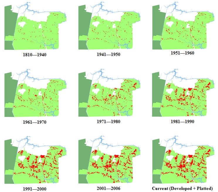
PROGRAM FOCUS
Although the City’s OSAP program was initially set up as a City wide program, it is best suited to address open space issues within
Southern Chesapeake. This is the location of the City’s prime agricultural land, high quality natural lands, and the watershed for one
of the City’s main drinking water supplies. The existing tools available for open space protection lend themselves very well to the
types of land and resources found in Southern Chesapeake. This is also an area that is under increased land conversion pressure
which will be discussed in more detail later in this report.

This is not to say that we should ignore open space needs in other sections of
the City, only that the City should use a different set of tools to accomplish
those goals. Due to the significant land values within areas of the City where
more intensive development is allowed and actively supported by public policy
(i.e. Urban and Suburban Overlay Districts), one of the best approaches is to
link open space provisions with the development of new residential areas. This
is exactly the approach taken by the Zoning Ordinance in Section 19-700,
which requires either the provision of open space within the new development
or payment into a fund for improvements to existing open space and acquisition
of new open space depending on the current open space availability within the
surrounding area. In January 2003, City Council adopted revisions to this
section of the ordinance to clarify the requirements for residential
developments. Linking development with open space protection can also have
limited application within Southern Chesapeake as limited planned growth
occurs. This will be discussed in more detail in the tool section of this report
along with a number of additional tools.

The City’s 2026 Comprehensive Plan recognized the unique characteristics of
Southern Chesapeake with the adoption of several policies that enhanced the
importance of the Rural Overlay District. The purpose of the Rural Overlay
District is to preserve and protect the rural character of the southern portion of
the City. The OSAP program is one of the primary tools that can be used to
meet this objective.

The total land area of the Rural Overlay that has been designated on the 2026 Land Use Plan as rural is around 92,500 acres. This
excludes Edinburgh, the Municipal Airport, and the designated light industrial node west of the Chesapeake Regional Airport, which
are all current or future development nodes in Southern Chesapeake. In order to get a better handle on the total land area that is
applicable to OSAP related policies and programs, the current Rural Overlay land uses located within the rural designation have been
broken down into the following general categories: Existing Conservation Lands, City of Chesapeake, Fentress Easements, Federal/
Institutional, Single Family Residential, and Rural/Natural Unprotected. There are also two other areas of note within the Rural
Overlay: the Northwest River Watershed and the Southern Watershed Area Conservation Corridor.
                                                                                                                                         6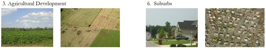
RURAL OVERLAY
    92,500 Acres                                                          =

 Existing Conservation Lands
 Within the Rural Overlay there is approximately 12,400 acres of
 land that can be classified as conservation land. This represents a
 land area of around 13% of the Rural Overlay (shown in dark
 green on the map).           This is land owned by three major
 landholders – the Nature Conservancy, the Virginia Department
 of Game and Inland Fisheries, and the Virginia Department of
 Conservation and Recreation. Due to these agencies respective
 missions, this land can be considered permanently protected from
 development. This category does not include existing or
 proposed wetland mitigation banks which would add
 approximately 3,000 acres to this total. Because of the existing
 mitigation bank credit supply in this area of the City, it is unlikely
 that any new banks will be proposed in the near future within the
 Rural Overlay. The 108 acre McPherson Farm is also included
 in this total. The last item to note is that the Great Dismal Swamp
 was also excluded from both the conservation land total and the
 total land area for the Rural Overlay because of its status as a
 Federal Wildlife Refuge. The Great Dismal Swamp
 occupies around 52,000 acres in Chesapeake.

                                                               +              7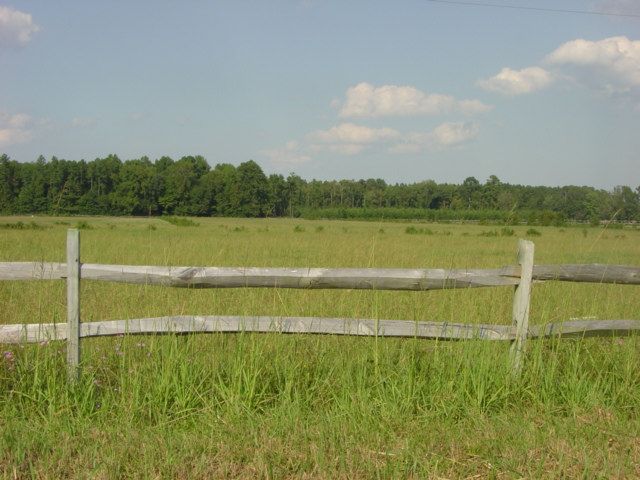
Federal/Institutional
                                                                     This category includes land owned by the Navy (Fentress and
                                                                     Northwest Radio Station), the City of Norfolk, and the Saint
                                                                     Brides Correctional Facility. The total land area covered by
                                                                     this category totals approximately 7,500 acres or 8% of the
                                                                     Rural Overlay (shown in gray on the map). Natural lands
                                                                     within the boundaries of both of the Navy’s holdings can play
                                                                     an important role in protecting and enhancing our natural
                                                                     landscape if they are managed appropriately. It is also
                                                                     important to note that the City’s OSAP program can play a
                                                                     critical role in helping manage the threats of encroachment
                                                                     around the Northwest Radio Station in a proactive manner.

Fentress Easements
                                                           +
Over the years the Navy has acquired approximately 8,250 acres
of easements surrounding the Fentress Landing Field. This
represents 9% of the land area of the Rural Overlay (shown in
orange on the map). The main purpose of the easements is to
protect the operation of the landing field from incompatible uses.
Due to the nature of these easements, the working and natural
lands around Fentress have been protected in a fashion very
similar to the City’s existing Purchase of Development Rights
Program. Two issues within this area merit future consideration.
The first are uses that are incompatible with the City’s existing
land conservation policies such as intensive logging of natural
hardwood forests. The second is the long term land use plan for
this area which is dependent on the future of the landing field.

                                                           +                                                                         8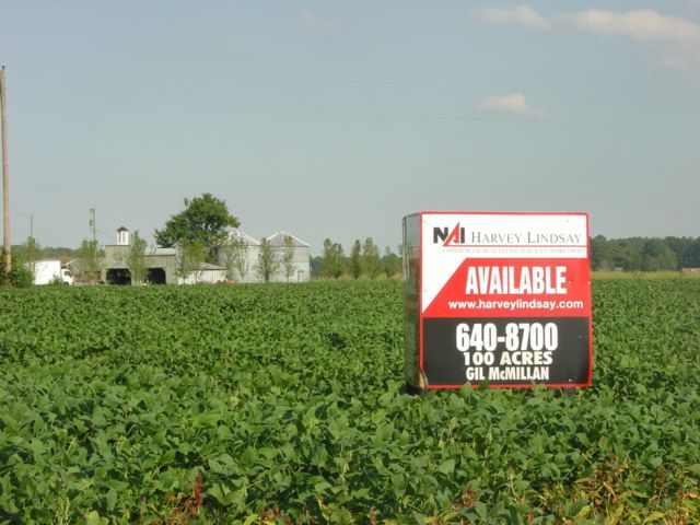
City of Chesapeake
                                                                        The City of Chesapeake owns approximately 1,650 acres or 2%
                                                                        of the Rural Overlay (shown in purple on the map). This
                                                                        includes land used for public facilities (e.g. fire stations) as well
                                                                        as land designated as recreational areas. Land such as the
                                                                        Northwest River Park and the land between the Cavalier Tract
                                                                        and the US Navy Northwest Radio Station could be classified as
                                                                        existing conservation land given the land use intent and the
                                                                        characteristics of the existing land cover. Both of these pieces
                                                                        can serve as useful models for the management and use of future
                                                                        City of Chesapeake land holdings within Southern Chesapeake.
                                                                        The Northwest River Park is used for passive recreational
                                                                        purposes that serve to complement the natural values of the site.
                                                                        The City land adjacent to the Cavalier Tract is managed for
                                                                        conservation purposes in partnership with the Virginia
                                                                        Department of Game and Inland Fisheries.

Single Family Residential
                                                               +
There is approximately 15,500 acres of land within Southern
Chesapeake that has either been developed or platted for single
family residential. This represents 17% of the Rural Overlay
(shown in red on the map). The overwhelming majority of this
acreage has been subdivided into 3 acre lots.             Residential
development in the Rural Overlay will be discussed in much
greater detail in the land conversion section of this report.

                                                               +                                                                                9
Rural/Natural Unprotected
This category includes all existing undeveloped and
unprotected working lands (agriculture and managed forestry)
and natural lands. This category includes approximately
50,100 acres or 54% of the Rural Overlay. This category is
the true focus area of the OSAP/rural program because this is
where the City’s current and future land use policies will have
the most direct impact on how Southern Chesapeake and the
City as a whole will look years into the future. The City has a
unique opportunity and responsibility to protect and enhance
the valuable resources contained in this area.

RURAL LAND MANAGEMENT UNITS

Because of the size of the area under the rural/natural unprotected category, it has been further broken down into management units to
help determine the unique threats, tools, and opportunities available to help preserve the special characteristics of each unit. For each
unit, different tools will be utilized as necessary to reflect the unique issues inherent within each. These categories were adapted from
the Southern Watershed Area—Rural Area Preservation Program Final Report from September 2001:

1. Agricultural Lands (AL) - Lands with prime agricultural soils and associated land units which are used for, or could be used for,
   productive agriculture and sustainably managed timber tracts.
2. Environmentally Sensitive Land (ESL) - Areas that contain significant natural resources such as non-tidal wetlands, natural resource
   buffers, and natural forested areas.
3. Scenic Resource Lands (SRL) - Areas that contain or constitute scenic viewshed resources important to the community character of
   Chesapeake. This unit is not a stand alone unit but serves as an overlay on portions of both the AL and the ESL units mainly along
   the rural road frontage.
4. Rural Infill Lands (RIL) - Land areas that are adjacent to areas of existing non-agricultural residential development that can
   accommodate additional residential development without substantial negative impacts to adjacent land and community character or
   impacts could be significantly minimized with proper layout and design.
5. Rural Development Lands (RDL) - Lands that are the most suitable for more intense future development. In the context of Southern
   Chesapeake, the only areas that fit into this category would be Edinburgh and the proposed commerce park west of the Chesapeake
   Regional Airport.
                                                                                                                                            10
OTHER UNIQUE AREAS WITHIN THE RURAL OVERLAY
Beyond the different land uses and management units located within the Rural Overlay, there are two other district areas that are
important to consider —the Northwest River Watershed and the Southern Watershed Management Program Conservation Corridor
Northwest River Watershed
The Northwest River runs through the lower middle half of the City’s Rural
Overlay. Its watershed is highlighted in blue on the map to the right and is
overlaid on the existing undeveloped land area in Southern Chesapeake as
described on the previous page. From an intake point located adjacent to South
Battlefield Boulevard (shown with a red dot on the map), the Northwest River
Water Treatment Plant provides up to 10 million gallons per day of drinking water
to the citizens of Chesapeake. In recognition of this important water resource, the
City adopted the Northwest River Watershed Protection Ordinance in June 2005.
This ordinance has many goals that overlap with the OSAP program. To protect
this critical water resource, steps need to be taken to actively manage this
important watershed and protect the land resources and forested wetlands that
provide tremendous source water protection and natural treatment.
Southern Watershed Area Management Program (SWAMP)
SWAMP was developed in partnership with the City of Virginia Beach, the
Hampton Roads Planning District Commission (HRPDC) and the Virginia
Coastal Program to protect natural resources, sensitive land, and water supplies
within the Southern Rivers Watershed Area. The area includes the watersheds of
Back Bay, North Landing River, and the Northwest River. This cooperative
effort has been ongoing for over a decade, first starting in the early 1990’s and
leading to many important studies and policies for this area. One of the most
important outcomes of this process was the development of conservation
corridors which identified the most significant natural resources that remain in
this area and connected them through linear systems of open space (shown in
purple on the map). These conservation corridors also generally identify the
areas most critical to protect within the watershed of one of our main drinking
water supply sources. Currently, 9,800 acres (11% of Rural Overlay) within the
SWAMP corridor remains unprotected. The HRPDC has used the SWAMP
approach to expand this network throughout the region with a recent study of
Green Infrastructure. Green Infrastructure helps us identify and recognize the
ecological services that our natural lands and open space provide to our
communities. 11Program Goals
When the City considers the goals for the OSAP program, we are really thinking about the values that we place on the land area of
Southern Chesapeake. These goals represent the articulation of the core values that make Southern Chesapeake a special area which
has sustained this community for many decades and contributes greatly to the unique quality of life of Chesapeake. It is an area that
creates a unique sense of place to this community that is distinct from the suburban development patterns and designs that have
dominated the City’s growth areas over the last few decades. Many of these values are reflected in the purpose statements of both
the OSAP Ordinance and the Northwest River Watershed Protection Ordinance. They are also articulated in the 2026
Comprehensive Plan. All of these documents contain numerous compatible goals that can be summarized for this analysis into four
main goal statements:
The City of Chesapeake will take an active role in:
• Helping to sustain and protect working lands
• Preserving rural character
• Protecting valuable natural lands/natural resources
• Providing public open space for both passive and active recreation
Within these broad goal statements we can explore how they relate to the rural land use management units and how these goals can
be met with the management of those land types. This concept will be articulated in more detail in the land preservation tool section
of this report. The flip side of this is to explore how a laissez-faire or hands-off approach to managing these land units can impact
the City’s goals/values. This will be considered in more detail within the land conversion section of this report.
The other point to consider is how to define progress in meeting the goals of OSAP and to provide benchmarks to measure successes
or failures. One method that related programs have used is to establish numeric goals. These goals can be expressed as a percent of
land protected as in Virginia Beach (20% of their agricultural lands), or as acreage targets as in Isle of Wight (2,000 acres by 2010).
Having numeric goals can be useful in helping measure the progress of the program but also can be somewhat arbitrary. The
attainment of such goals will largely depend on future land values and the availability of program funding. It is also unclear as to
what amount or percent of protected land represents a viable amount. How many acres of the 50,000 acre total focus area would the
City need to protect in order to meet our program goals? Is the protection of 20% of the working lands in Chesapeake enough to
make this type of land use economically sustainable? It is impossible to determine the answer to those questions since there are
many unknowns and also many factors which impact the dynamics of land use in Southern Chesapeake which the City has little
control over (e.g. commodity prices, age of farmers, etc.). It is clear though that the City will have to prioritize based on protecting
land that provides multiple benefits to the community and emphasize the quality of protected land over the quantity. Much of our
valuable natural and working lands have been identified within the SWAMP effort through conservation corridors within the Rural
Overlay. Chesapeake must evaluate all land use decisions on their relationship to our broad program goals and how they relate to our
management units and protection of resources within the established SWAMP conservation corridors.
12Land Conversion
When discussing natural and rural land protection, one of the most important factors to consider is land conversion. In particular, land
that is being converted to “rural” residential is key to this discussion. Land conversion to residential land is important for many
reasons and will ultimately determine the character of Southern Chesapeake. The photos below illustrate the general process by
which land conversion of rural and natural lands takes place using current photos from Chesapeake. The process occurs at a variable
rate and is dependent on many factors such as adjacent land use patterns, land use regulations, and land economics. It is very
important to note that this is a one-way process and once a certain threshold has been reached all other adjacent land uses will be
converted to residential uses. All of the City’s current undeveloped land will reach the ultimate endpoint of stage 6 (possibly stage 5
depending on land use regulations) unless we take steps to manage and protect our rural lands. The conversion to rural residential
represents a permanent change to our landscape. Chesapeake only has one opportunity to ensure that we can accommodate limited
growth in a manner and location that complements and does not compromise the goals/values of the City’s unique rural landscape.
13THE CHANGING CHARACTER OF SOUTHERN CHESAPEAKE:
Residential Growth in the Rural Overlay
This series of maps
illustrates the spread of
residential growth (shown
in red) throughout the
decades within the Rural
Overlay. It is this type of
uncoordinated and
fragmented growth that
can compromise the City’s
values/goals for this area
and lead to more land use
conversion.
14THE CHANGING CHARACTER OF SOUTHERN CHESAPEAKE:
Residential Growth in the Rural Overlay
15LAND CONVERSION PROFILE: 100 ACRES ON TAFT ROAD
As discussed previously, conversion to “rural” residential
1/3 mile
represents permanent change. This change occurs not only to the
land that is platted for residential but also to adjacent lands. 1/5 mile
Improperly located residential leads to conflicts with adjacent land
uses. This is particularly apparent when considering impacts to
agricultural lands. Here is a list of potential conflicts: noise, dust,
pesticide use, odors, vandalism, traffic, and decreased incentive to
invest due to imminent land conversion and rapidly increasing
õ
land values.
While there is no hard and fast rule to the extent of the conflict
area impacted by these factors, it is clear that units in closer
proximity to the operation leads to more conflicts, as does an
increase in the number of units. Studies by the American
Farmland Trust have seen measurable impacts at 1/5 to 1/3 Farmville Road
miles from the operation. Each of these factors contribute
to land conversion by making it no longer economically viable or
operationally feasible to continue farming the land. This is a
process that leads to land conversion by default.
100 ACRE FARM ON TAFT ROAD
To illustrate this type of land use change an actual example off of Taft
Road will be examined. The highlighted property is a 100 acre farm
tract that over time has been encroached upon by incompatible
residential uses. Recently this farm was being marketed as land in the
“path of development.” This is an example of how incremental and
unplanned change that can lead to “default” land conversion. In this
case, the land is changing from an Agricultural Land (AL) unit to a
Rural Infill Land (RIL) unit. If a build-out of residential uses adjacent
to this property was shown, we would see that this path was laid out
incrementally over many years, with a tremendous amount of
development pressure over the last decade or two. It was the result of
an accumulation of individual actions with no real relationship to the
land or the context of the rural environment.
16LAND CONVERSION PROFILE: 100 ACRES ON TAFT ROAD
This potential development site on Taft Road is an example of how the City’s rural values/goals can be compromised by a default
land use conversion. One of the only viable land uses left with all of the existing residential encroachment is more residential.
Chesapeake needs to restructure the City’s current land use regulations, policies, and land protection tools so that the norm of land
conversion complements and supports the City’s rural goals while providing for limited development. In terms of the particulars of
how this compromises the City’s values we can first look at rural character. With the entire road frontage of this site “piano-keyed”
with large lot residential, the rural character of this area has been greatly reduced. The residential uses dominate the visual landscape
obscuring the open fields and rural setting. This piano key development has also compromised the functionality and use of the
working farm land by introducing a number of conflicts. If this were prime soils, some of the City’s most productive farmland would
be compromised. This same scenario could be used as an example for conversion of natural lands, where habitat fragmentation
occurs and where lose of some of our valuable ecosystem services occur like drinking water source protection and filtration.
It is clear that the City must reach a balance between sometimes conflicting goals. Although the City may not be able to achieve
them all, we must strive to maximize the benefits and values that these lands hold to our livelihood and quality of life. In the case of
this area, a similar level of residential density could have been achieved, but better planned for and designed using tools such as
cluster zoning. This technique allows the City to preserve property rights while protecting our most valuable land assets.
Farm (in yellow) shown
in context with the
existing and platted
Farm (in red) shown in “rural” residential (red).
context with the existing
rural undeveloped land. 100 ACRE FARM ON TAFT ROAD -
LOOKING TOWARDS THE EAST
17Conservation Toolbox
There is no silver bullet in terms of protecting our rural and natural lands. In fact, it is a series of tools and actions that when used in
combination will help the City achieve and maximize the goals/values for Southern Chesapeake. While OSAP has been designated
as a Purchase of Development Rights Program, Chesapeake will need to expand the toolset in order to make any real progress toward
the City’s goals. This is especially important given the fact that there are 50,000+ acres of land that an open space/rural preservation
program potentially addresses and the City currently has very limited funding to reach these goals.
The following tools will be evaluated in this section of the report:
Purchase of Development Rights, Transfer of Development Rights, Tax Incentives—Local/Federal/State, Grants, Fee-Simple
Purchase, Development Regulations.
18PURCHASE OF DEVELOPMENT RIGHTS
Description: The program works by purchasing the development rights from a land owner to prevent the land from developing into
single family residential. The landowner still owns the land and can continue to live on the property and manage the land for
agricultural production, forestry, and/or conservation. A permanent conservation easement is placed on the property that is held by
the City and/or a qualified third party. The value of the development rights is currently determined by subtracting the appraised
value from the agricultural or open space value of the property. With the City’s program, each enrollment application is ranked by
criteria contained in the ordinance to help determine the priorities for purchase. Even with very minimal promotion of the program
during our first and only application period, the City received over 20 applications for enrollment covering over 2,000 acres of land,
indicating a very high level of interest in the program. One of the main disadvantages of a PDR program is the program cost. The
only purchase that has been made so far in the City’s program is the McPherson Farm which was purchased at a land value of
$14,500 per acre or $111,857 per development right (12 development rights purchased). When developing the program, the City
structured it to use an Installment Purchase Agreement (IPA) method versus an outright purchase of the development rights based on
the Virginia Beach PDR program. While the IPA approach helps the City finance the upfront cost of the transaction (~0.30 per
$1.00) at current land prices, the City has ongoing interest payment obligations over 25 years that in the McPherson case adds over a
million dollars to the cost of the transaction. If you extrapolate these costs over the City’s 50,000 acres of rural/natural unprotected
lands, the cost of buying the development rights on even a portion of that total is considerable. The success of Virginia Beach’s
PDR program (+7,000 acres enrolled) can be attributed to lower land costs and a substantial local dedicated funding source.
Goals Addressed: This tool addresses three of the main goals of the program. By protecting the traditional working land uses in
Southern Chesapeake the rural character is also preserved. If applied to the right land areas, this can also be used to protect sensitive
natural lands and resources. Because of the nature of some of these resources (e.g. forested wetlands), future land use will be more
restricted than when PDR is used for working lands. This tool does not address the goals of protecting lands for both passive and
active recreation because there is generally no public access with the easements.
Applicability to which Rural Management Unit:
• Can be applied to both the Agricultural Lands (AL) and the Environmentally Sensitive Land (ESL)
• Especially useful when the AL and the ESL is overlaid by the Scenic Resource Lands (SRL)
• Chesapeake's PDR program is currently structured to address both Agricultural land and Open Space
Advantages
• Voluntary
• Helps sustain the operation of working lands with influx of cash
• By using an Installment Purchase Agreement (IPA) the City pays lower upfront cost at the current land values
Disadvantages
• Expensive and requires long term funding commitment—25 years of interest payments with IPA
• No public access or use of land
• The use of an IPA for the purchase is administratively complex
19TRANSFER OF DEVELOPMENT RIGHTS
Description
In 2006, Governor Kaine signed legislation that allowed localities in Virginia to adopt a Transfer of Development Rights (TDR)
program for their communities. A TDR program is similar to a PDR program. In both programs, development rights are purchased
from willing landowners. In a TDR program a private developer rather then the City would buy the development rights from an area
of the City designated as a “sending area” and transfer those development rights to an area designated as a “receiving area” in order
to gain an increase in density. Some states with existing TDR programs allow cities to purchase and bank development right credits
to sell or transfer to a private developer. As with a PDR program, the landowner still owns the land and a conservation easement is
placed on the property. The price of the development right is negotiated by the two private parties involved in the transaction.
In general, the concept of TDR supports the land use policies of the City’s Comprehensive Plan by helping to protect land within a
designated area in the Rural Overlay (sending area) and encourage development and redevelopment in a designated area in the Urban
Overlay and possibly the Suburban Overlay (receiving area). It also has the potential to help the City meet other public policy goals,
such as encouraging the construction of affordable housing units by providing for increased density.
Goals Addressed
This tool addresses three of the main goals of the program. By protecting the traditional working land uses in Southern Chesapeake
the rural character is also preserved. If applied to the right land areas, this can also be used to protect sensitive natural lands and
resources. Because of the nature of some of these resources (e.g. forested wetlands), future land use will be more restricted than
when TDR is used for working lands. This tool does not address the goals of protecting lands for both passive and active recreation
because there is generally no public access with the easements.
Applicability to which Rural Management Unit
• Can be applied to both the Agricultural Lands (AL) and the Environmentally Sensitive Land (ESL)
• Especially useful when the AL and the ESL is overlaid by the Scenic Resource Lands (SRL)
Advantages
• Voluntary
• Helps sustain the operation of working lands with influx of cash
• Limited public funds are used
• Can be used to encourage redevelopment and infill development
Disadvantages
• Potentially difficult to administer
• Potentially time-consuming for developers
• No public access or use of land
• Increased densities can lead to citizen opposition if not placed in the appropriate location and properly designed.
20FEE SIMPLE PURCHASE
Description
This is a tool used by the City for many of our public facility/infrastructure needs. It is the most straightforward of all land
conservation tools and the most understood by the City. It is a tool that guarantees that the land purchased will be used for the
intended public purpose. It also is one of the few conservation tools that not only protects the resource, but also usually allows public
access and use of the property. Allowing public access to Chesapeake's rural and natural lands helps to greatly enhance the public
benefit and allows for residents to have a physical connection to a landscape that holds many important values to the community.
Purchased property can be used to meet many community needs such as recreation (passive and active), conservation, and limited
public facilities. Within this set of land uses we can also meet some of the City’s other strategic goals such as preventing
encroachment to our military facilities and protecting our drinking water source. The other possibility is land banking where we can
meet the City’s future needs with current land prices.
Goals Addressed
Can be the most effective tool for protecting natural lands, scenic resources, and recreational space. Because of public ownership of
the land it is not as effective for protection of working lands, although public land could be leased to farmers on a interim basis.
Applicability to which Rural Management Unit
• Can be applied to both the Agricultural Lands (AL) and the Environmentally Sensitive Land (ESL)
• Especially useful when the AL and the ESL is overlaid by the Scenic Resource Lands (SRL)
Advantages
• Voluntary
• Allows for public access or use of the land
• Ensures the long term protection of the land
Disadvantages
• Can be slightly more expensive than only buying development rights due to higher upfront cost
• Removes property from tax rolls (impact limited due to land use value taxation)
21TAX INCENTIVES — LOCAL/STATE/FEDERAL
Description
There are a number of very generous tax incentives that exist for landowners in Virginia. On the local level, the City already takes
advantage of one key tax incentive that is available to protect rural and natural lands. In Chesapeake, as with the majority of
localities with rural lands in the State, certain natural and agricultural lands are taxed at a land use value which can be substantially
less than the market value of property within the City. At the state level, the Virginia Land Preservation Tax Credit Program, is one
of the most generous tax credit programs in the country. It allows landowners to receive a tax credit for 40% of the fair market value
of a bargain sale (difference in market value vs. sales price) or a donation of a conservation easement. If the landowner does not
have the tax liability to take advantage of the tax credit, the credit can be sold on the open market to another tax paper for a slightly
reduced cost. On the federal level, there is a tax deduction program in place that allows for a maximum deduction of 50% of an
individual’s adjusted gross income (AGI) for donating a conservation easement or selling an easement at a bargain price. Qualified
farmers and ranchers can deduct up to 100% of their AGI.
Combining these incentives allows land owners to make up for a significant portion of the value of their donation or bargain sale.
These incentives can be combined with PDR purchases, fee-simple purchases, or conservation easement donations to create flexible
incentive packages that meet the needs of both the City and the landowner. The City is currently working with two landowners for
easement donations in Southern Chesapeake. These donations can be directly attributed to this combination of generous tax
incentives.
Goals Addressed
The goals that this tool addresses depends on the type of transaction it is used with (Conservation Easement Only vs. Fee Simple
Purchase).
Applicability to which Rural Management Unit
This also depends on the type of transaction it is used for.
Advantages
• Voluntary
• Helps sustain the operation of working lands with influx of cash
• Helps to leverage state and federal funds while limiting local expenditure
• Statewide this has been one of the primary drivers of many of the conservation donations throughout the State
Disadvantages
• To take full advantage of Federal Tax Deduction must be a qualifying landowner
• No public access or use of land (depending on transaction type)
• City does not control availability
22GRANTS
Description
Grants from both the state and the federal government are able to help supplement local funding for land protection efforts. Unlike
other government grant categories there is limited funding at the state and federal level for land conservation. The limited grant
programs that exist are also extremely competitive. As an example of this, the State received 31 applications totaling over $24
million for the last funding cycle of the Virginia Land Conservation Foundation and awarded only 15 grants for a total of $6.2
million. The City of Chesapeake’s grant application was not funded.
The City has had only limited success at securing outside grant funds for land conservation. Because of this fact, their applicability
to Chesapeake is limited and should only be thought of as a finite source of supplemental funding to enhance a local dedicated
funding source. Other disadvantages include the administrative burden associated with grant applications, tracking and reporting,
and the time lag that exists in most grant programs between the application period and eventual award. Most grant programs require
a minimum 50% local match with some requiring a higher percent.
Goals Addressed
Can address all goals depending on what type of transaction the grant is used for.
Applicability to which Rural Management Unit
Can apply to all units depending on the focus of the grant program.
Advantages
• Helps to leverage state and federal funds while limiting local expenditure
• Grant program focus compatible with the types of lands found in Southern Chesapeake (agricultural and natural)
Disadvantages
• Limited funds available
• A local match is almost always required
• Very competitive
• Administratively burdensome
• In most cases a significant time lag exists between application and award
23DEVELOPMENT REGULATIONS
Description
The City of Chesapeake has numerous regulations that cover every aspect of the development process. This holds true for Southern
Chesapeake although at a lesser degree due to the somewhat limited development opportunities as opposed to the northern half of the
City. Within these regulations exist certain loopholes and inconsistencies that undermine their effectiveness in helping to preserve
the rural character of Southern Chesapeake. The potential exists for these regulations to be revised to both protect the development
rights of landowners while ensuring that our development review and approval process complements rather then compromises our
values/goals for Southern Chesapeake.
A key tool under development regulations is the cluster subdivision ordinance provision. A properly structured cluster subdivision
ordinance can be one of the most effective tools that we have available. This type of ordinance can help us virtually eliminate piano
key subdivisions that ruin the rural character of Southern Chesapeake while providing for a connected system of open space linked to
regional conservation corridors. It also helps to protect and restore the City’s existing natural resources. The other key tool under
development regulations is to ensure that the layout, design, and engineering of any potential development in Southern Chesapeake is
consistent with the rural character of the area as opposed to the utilizing the same design standards of our suburban and urban
developments.
Goals Addressed
This tool mainly deals with protection of land for open space recreation use with some applicability to protection of natural
resources. It has the potential to help protect scenic resources. It can help to prevent use conflicts with adjacent agricultural land but
has limited potential to protect agricultural land.
Applicability to which Rural Management Unit
• Can be applied to both the Agricultural Lands (AL) and the Environmentally Sensitive Land (ESL)
• Can be especially useful when the AL and the ESL is overlaid by the Scenic Resource Lands (SRL)
Advantages
• Helps protect the investments of neighboring landowners in terms of the use value, market value, and conservation value
• Provides for an important balance to land conservation incentives programs
• Can provide for a predictable process
• Provides for a necessary balance between individual property rights and overall community goals
• Protected open space can be linked to community wide network
Disadvantages
• No public access or use of land (dependent upon the structure of the regulation)
• Landowners resistant to change
24Moving Forward: Recommendations
In order to increase the effectiveness and cost efficiencies of the City’s Open Space/Rural Protection Program, the following
prioritized list of recommendations are provided to help guide policy decisions in regards to implementation and next steps.
I) Focus, strengthen, and leverage the City’s existing PDR Program
a) Address the development rights cost issue within the PDR program
As discussed in the program tool section, the main disadvantage to a PDR program is the cost. While the City cannot directly control
the value of land in Southern Chesapeake, there are a number of ways in which we can help make the program more cost effective
while still providing benefits to the landowners. One method to help reduce the cost is to set up a cap on the price paid for each
development right. This is a strategy that Fauquier County uses for their program where they have capped the price at $30,000 per
development right. The value of a development right cap would need to be studied for Chesapeake and periodically adjusted based
on the market and available funding. This method can help the City take advantage of the state and federal tax incentives which were
discussed in the tool section. Taking advantage of these incentives can allow the land owner to regain much of their value for a
potential bargain sale to the City. The other way to take advantage of those incentives is to pay only a certain percent of the
appraised price of the land, such as 75% or 80%. The difference in value between the sales price and the market price would qualify
the landowner to take advantage of the tax incentives for a bargain sale.
b) Focus the program on achieving multiple benefits with emphasis on rural character and natural areas
Due to the amount of land eligible for this program (50,000 acres) and the land values in Southern Chesapeake, we need to prioritize
our efforts and do more with less. In order to achieve this the City should revisit the current PDR ranking system to ensure that
multiple benefits are achieved with each transaction. There will never be enough funding to sustain the viability of the agriculture
land uses in Southern Chesapeake with a PDR program.
c) Maximize state funding
In the last General Assembly session, $4,250,000 was allocated to the Virginia Department of Agriculture and Consumer Services
(VDACS) Office of Farmland Preservation to administer a 50:50 match program that is open to all of the State’s PDR programs.
Because of how the allocation is structured, Chesapeake is guaranteed to receive $300,000 in matching funds but could receive two
or three times that amount depending on what we have available to use as a local match. This is currently a one time infusion of cash
for local programs. A more permanent state funding solution may emerge out of the report of the General Assembly’s Joint
Subcommittee studying long-term funding for the purchase of development rights to preserve open-space and farmlands. This report
is due to the General Assembly by the beginning of next year’s legislative session.
d) Provide for flexibility with the terms of purchase
Although there are certain advantages to the City and the landowner by using the Installment Purchase Agreement approach to
purchasing development rights, there should be mechanisms that allow for the City to outright buy the development rights or to
modify the terms of the IPA purchase (e.g. 20 year bond vs. 25 year bond) depending on the needs of the landowner and the City.
25Moving Forward: Recommendations
II) Utilize and emphasize fee simple purchase for key priority parcels within Southern Chesapeake
a) Create a targeted program for property within the SWAMP conservation corridor
This is the type of purchase that has the potential for the City to partner with conservation groups and the State (e.g. Cavalier tract)
due to the nature of the resource that is being protected. If you look at the existing conservation lands in Southern Chesapeake, these
groups have provided for the overwhelming majority of land protection currently exhibited in Southern Chesapeake. The City cannot
assume that this trend will continue and relying solely on these partners to protect our resources will ensure that there are
opportunities lost for the protection of land that provides environmental services to the community and preserves our unique natural
heritage. Chesapeake has to take an active role in protecting this land to ensure that it continues to provide essential benefits to the
community.
b) Actively seek partnerships with the State and Federal government for land acquisition within the Interfacility Traffic Area
The City is currently involved in implementing this recommendation with the grant award from the State (Virginia Military Strategic
Response Fund) to purchase ~350 acres of land. The City is also currently working closely with the Navy to secure funding to
continue the purchase of high priority land adjacent to the land being acquired with the State funding. This is an example of the
multi-benefit approach to land acquisition, because not only will this land purchase help us to meet our BRAC directives but it will
also ensure that we protect high priority conservation land that is included within our proposed conservation corridor network.
c) Explore partnership with Public Utility Department for targeted drinking watershed protection acquisition
A few years ago the City gave a $100,000 grant to the Nature Conservancy for a Northwest River Watershed Study. The Nature
Conservancy and the City have been in contact recently with the Hampton Roads Planning District Commission (HRPDC) to work
on this project. This study has the potential to help quantify some of the benefits that land conservation has the City’s drinking water
resources. Research from the American Water Works Association in partnership with the Trust for Public Land indicates that this
type of approach is being implemented across the country with many positive results.
III) Promote the availability of land conservation tax incentives
As mentioned in the tool section, landowners in Virginia have access to generous tax incentives on both the State and Federal level.
Unfortunately, not many landowners are aware of these incentives. In order to help facilitate the utilization of these incentives, it
would be beneficial to promote them through targeted mailings and the use of the City’s website. Recently the City has had two
landowners approach us to accept an easement donation so that they could take advantage of these incentives. This could be a more
common occurrence if more landowners had information on the incentives.
26Moving Forward: Recommendations
IV) Create a dedicated local funding stream for open space protection
This recommendation was specifically listed as a City Council goal on the Council’s Two Year Goal summary from January 20,
2007. Without fulfillment of this recommendation, the implementation of recommendation’s I and II will not be possible. Currently
the OSAP program receives funding from 4 main sources as follows:
1) The largest contribution for OSAP comes from the annual appropriation of roll back taxes. The past two fiscal years have
provided around $400,000 to the OSAP account. With the real estate market slowing down it is likely that this number
will decrease over the next fiscal year.
2) The second largest contribution is the $300,000 transfer from excess Mosquito funds that has taken place over the last two
fiscal years.
3) The third contribution comes from revenues collected for public street closures. This is a very limited funding source
with revenues of $80,000 and $3,000 over the last two fiscal years.
4) The fourth source of funds is from grant funding. The City has only received $100,000 from this source over the past two
fiscal years, despite applying for a number of grants. The limitations of grant funding were discussed in the tool section
and should only be used in very limited cases to supplement funding for specific projects.
The OSAP program does not currently have a reliable funding source that can be depended on to sustain the program over the long
term. The current sources can fluctuate greatly from one year to the next and the total amount available in our current funding
streams do not raise the level of funding necessary to have a program that can implement our program goals for Southern
Chesapeake.
a) Identify a general fund revenue source
There are a number of possible revenue streams that could be considered for use by the OSAP program. Some possible sources of
additional funding for OSAP:
1) A dedicated portion of the local recordation tax. A dedicated recordation fee is used on the state level to help fund the
work of the Virginia Outdoor Foundation. As a tax on land transfers, it has a similar nexus to open space preservation as
with the appropriation of roll back taxes.
2) A dedicated portion of the real estate tax. Both James City County and Virginia Beach use this as the primary funding
source for their successful open space programs.
3) Redirection of existing Mosquito Funds. Although currently the OSAP program receives some funding from this source,
additional money may be available for OSAP.
27You can also read