Neighbourhood Plan 2020-2026 - ABBOTS LEIGH, HAM GREEN, PILL, EASTON-IN-GORDANO - North ...
←
→
Page content transcription
If your browser does not render page correctly, please read the page content below

Neighbourhood
  Plan 2020–2026

ABBOTS LEIGH, HAM GREEN,
PILL, EASTON-IN-GORDANO

The Abbots Leigh, Ham Green, Pill & Easton-in-Gordano
Neighbourhood Plan was prepared on behalf of the two Parish
Councils of Abbots Leigh and Pill & Easton-in-Gordano by
a Steering Group drawn from the parish councils, the local
community and Alliance Homes. The Steering Group was
representative of all parts of the area and brought a range of
knowledge and expertise to the task.

Membership
Sue Adamson                                              Jo Tuckwell
(Easton-in-Gordano), Parish Councillor)                  (Pill; local employer)

Jill Coleman                                             Peter Stanley
(Easton-in-Gordano, Board member Pill and                (Pill, Parish Councillor)
District Community Land Trust)
                                                         Murray Stewart
Don Davies                                               (Abbots Leigh; Parish Councillor, Pill and District
(Pill, North Somerset Councillor for Pill/Abbots Leigh   Community Land Trust)
wards, Pill and District Community Land Trust)
                                                         Cathryn Vallender
Lucy Byrne                                               (Alliance Homes)
(Ham Green, Climate Change and Environment
Group)                                                   Martin Walker
                                                         (Abbots Leigh: Parish Councillor)
Bob Langton
(Pill, Pill and Easton Parish Councillor)                Trevor Wraith
                                                         (Easton-in-Gordano, Parish Councillor)
Rob Harvey
(Pill, Environment)
                                                            The Steering Group is grateful for the
Lin Matthews
                                                            engagement and support of many
(Pill, Chair Pill and Easton Community Forum)
                                                            local individuals and organisations. A
Peter Milner                                                full list is included in the Consultation
(Pill, Community)                                           Paper submitted with the Plan.

Alison Needler                                              Special thanks go to Celia Dring our
(Ham Green, Community)                                      liaison from North Somerset Council
                                                            who, over three years, has been full of
Stephen Robertson
                                                            constructive support and advice.
(Abbots Leigh, Business West)

Simon Talbot-Ponsonby                                                                     October 2020
(Abbots Leigh, Chair Parish Council, Pill and
District Community Land Trust)

The Neighbourhood Plan was available for local consultation from April 6th 2020. As a
consequence of COVID-19 the consultation period has been extended to 12th September.
Comments should be sent to nhoodplan@btinternet.com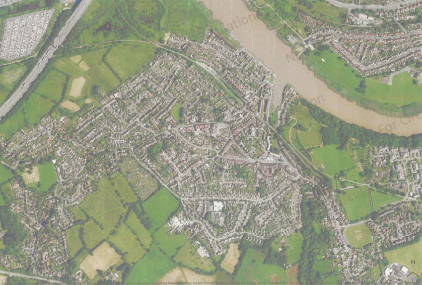
Contents
Volume 1 The Neighbourhood Plan

1     Introduction..................................................................................................................................................................4
2 Strategic Planning Framework......................................................................................................................... 5
3 The Neighbourhood Area and its History................................................................................................... 6
4 Vision, Principles, Objectives and Policies ................................................................................................ 8
5 Housing.......................................................................................................................................................................... 10
6 Transport and Movement.................................................................................................................................. 20
7     Landscape, Environment and Biodiversity............................................................................................. 29
8 Heritage.........................................................................................................................................................................33
9 Economy and Employment............................................................................................................................... 36
10 Climate Emergency................................................................................................................................................ 39
11 Community Assets and Facilities.................................................................................................................. 43
      Postscript......................................................................................................................................................................52

Volume 2 Background Papers                                                                     Maps

Housing                                                                                        Map 1             Neighbourhood Plan Area
Transport and Movement                                                                         Map 2             Pill Settlement Area
Environment                                                                                    Map 3             Community Land Trust:
Heritage                                                                                                         Search for sites

Economy and Employment                                                                         Map 4             Ham Green

Climate Change                                                                                 Map 5             Orchard View

Community                                                                                      Map 6             Chapel Pill Lane
                                                                                               Map 7             Rights of Way
                                                                                               Map 8             Pill Railway Station
     Copies of Volume 2 are to be found
     on the Neighbourhood Plan page                                                            Map 9             Landscape Features
     of the Neighbourhood Plan website                                                         Map 10 Abbots Leigh Heritage Area
     www.pillanddistrictplan.org                                                               Map 11            Open Spaces: Pill
                                                                                               Map 12 Open Spaces: Abbots Leigh
                                                                                               Map 13 Pill Precinct

                                                                                                Abbots Leigh, Ham Green, Pill and Easton-in-Gordano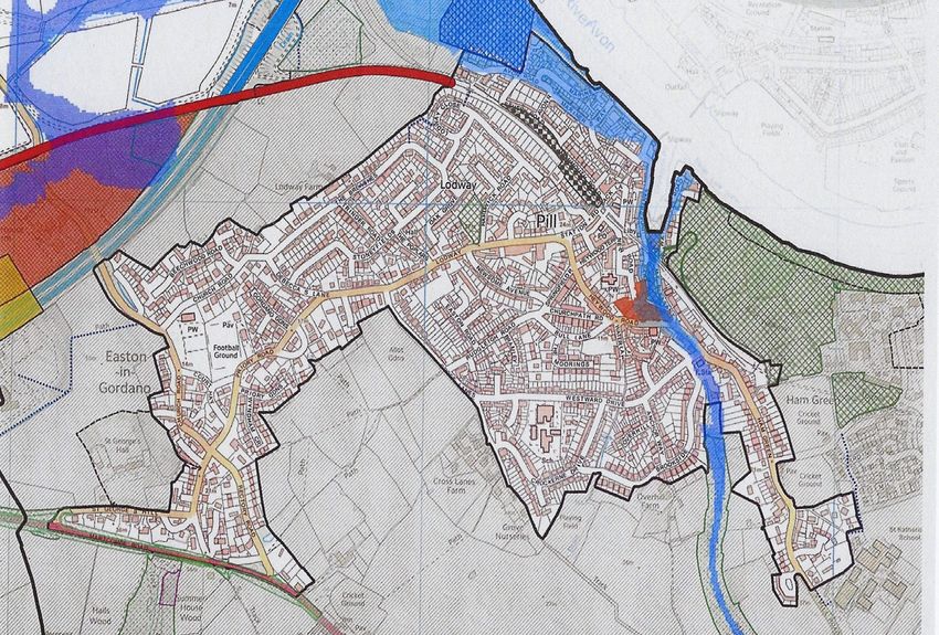
1 INTRODUCTION
1.1       What is the Neighbourhood Plan?

A Neighbourhood Plan is prepared in order      • A concern about urban sprawl from the
to guide the long-term development               edge of Bristol down to the M5 motorway
of an area. Set within the broader               should development be allowed to spread
context of national and local planning           along the A369.
policies and housing targets, the Plan         • A related concern over risks to the Green
reflects the community’s wishes about            Belt with valuable open space, together
the appropriate location and nature of           with environmental and heritage assets
local development. Underpinning all              at threat of loss.
aspects of the Plan is sustainability, with    • A recognition that the A369 is, and will
community engagement also crucial to             increasingly be, overloaded with related
the preparation of the plan. The Plan is         concerns about speed, safety, noise and
only approved after a local referendum.          pollution.
                                               • Appreciation that the Avon Gorge, the
The Localism Act 2011 encourages local           Avon itself and the longshore towards the
communities to draw up a Neighbourhood           Severn represented an asset valuable to
Development Plan. In areas where there           the whole neighbourhood area.
is a Parish Council it takes the lead in
neighbourhood planning. Abbots Leigh,          In July 2016, therefore, the Parish Councils of
Ham Green, Pill & Easton-in-Gordano are all    Abbots Leigh and Pill & Easton-in-Gordano
distinct settlements, but have a number of     agreed to undertake a joint Neighbourhood
important planning and development issues      Plan, with Pill & Easton-in-Gordano Parish
in common, including:                          Council having formal lead responsibility.

1.2       Preparing the Plan

A request to North Somerset Council in May     Through late 2018 and the first half of 2019
2016 for a Neighbourhood Area covering the     Background Papers were finalised and
whole of the two parishes was approved in      consultation moved ahead with a range
August 2016. Throughout 2017, effort was put   of events, meetings, interviews and mini-
into explaining to local communities what      questionnaires (details in the Consultation
the Plan involved, what were the challenges    Statement). A website was created and a
facing the area, and how preparation of        Steering Group established, drawn from the
the Plan would proceed. Initial consultation   two parish councils together with additional
revealed the key issues. In 2018 work was      community members with relevant skills
moving forward in the collection of data       and experience.
about the main themes of the Plan – housing,
transport, environment, heritage, economy,     From spring 2019 the outlines and structure
climate change and community. In the           of a plan emerged and in the autumn 2019
autumn of 2018 and again in autumn 2019        exhibitions of findings and proposals to be
grant funding was obtained from Locality,      included in the Plan were presented in three
and three consultants were commissioned        exhibitions across the Neighbourhood Area
to provide background analysis on transport,   in Abbots Leigh, Pill, and Easton-in-Gordano.
environment and energy.                        In November the Steering Group brought this
                                               material together and a first full draft plan

4     | Neighbourhood Plan 2020-2026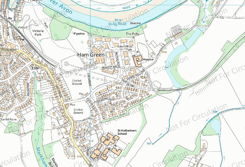
was finalised and agreed in January 2020.          Planning Policies which have a direct
The Plan was submitted to North Somerset           impact on plan-making and planning
Council for HRA/SEA screening in March 2020        applications (coloured in red).
and local consultation undertaken in a period
extended as a consequence of COVID-19              Community Action Policies which can
from mid-April to mid-September.                   be taken forward by the parish councils,
                                                   community organisations or other agencies
Background Papers were prepared to assist the      but are not explicitly planning focussed
community in understanding and responding          (coloured in blue).
to the key issues facing the neighbourhood.
They provide much of the information and           In order to assist both the local consultation
evidence on which the Plan is based but have       process and the subsequent North
been overtaken by further local consultation       Somerset Consultation (also six weeks),
and do not address recommendations for             and also to assure local residents that
policy. The main Plan text draws on, and           appropriate policies do exist, the policy
summarises, these Background Papers but is a       sections at the end of each chapter include
complete and free-standing document.               a list of those North Somerset Council
                                                   Core Strategy Policies and Development
Policy issues are addressed in the main plan       Management policies which apply, but are
and are divided into two categories:               not repeated in this Plan.

2 STRATEGIC PLANNING FRAMEWORK
For much of the time while this                    The strategic framework for this
Neighbourhood Plan was being assembled,            Neighbourhood Plan, however, remains North
the West of England Joint Spatial Plan (JSP)       Somerset’s current Development Plan which
was being prepared, and successive drafts          consists of its Core Strategy (January 2017), its
of the JSP provided a policy context for our       Development Management Policies (July 2016)
work. In August 2019, however, the strategic       and the Site Allocations Plan (April 2018). The
context changed. Public Examination of             implications of this are that our Plan assumes
the JSP and subsequent letters from the            that, with the exception of two sites in Ham
Inspectors indicated that they were minded         Green, the Green Belt remains as it is at
to conclude that the JSP was unsound.              present, the Pill Settlement boundary remains
                                                   unchanged and Abbots Leigh remains ‘rural’.
A new Local Plan 2038 is now being                 The policies suggested in the Plan relate only
developed and our Neighbourhood Plan has           to the period up to 2026.
been informed by the July Challenges and
Choices Consultation to which we made a            At the same time, however, much of our
submission. The two Parish Councils have           thinking still relates to the longer term and
also responded to the September 2020 Call          a number of the issues explored are clearly
for Sites by submitting the sites proposed         applicable to the fifteen years 2023-38. We
for the two development schemes set out            expect that once a strategic framework has
in Section 5.5 below. At the same time there       been finalised for North Somerset, hopefully
are Government proposals for changes to the        in early 2023, our Plan will be updated and/
planning system, to local housing numbers          or revised and we are happy to make a
and to the Green Belt, all of which will have an   commitment that this will be done.
effect on long-term thinking about our area.

                                              Abbots Leigh, Ham Green, Pill and Easton-in-Gordano   |   5
3 THE NEIGHBOURHOOD AREA AND ITS HISTORY
3.1        The Neighbourhood Plan Area

In May 2016 a proposed Neighbourhood                              public access walking and cycling for both
Plan Area (NPA) covering the whole of the                         leisure and travel to work. The employment
two parishes, including Royal Portbury                            opportunities offered by the Dock and the
Dock, was put to North Somerset Council.                          traffic implications of its operations have
Following community consultation and                              consequences for the rest of the NPA as
comments from a number of individuals,                            does an ongoing review of air quality.
agencies and organisations the Council
accepted the proposal in autumn 2016.                             In terms of traffic and movement the
                                                                  NPA is dominated by the busy and often
The 16 sq.km. NPA covers the two parishes                         overloaded east/west Bristol to Portishead
of Pill & Easton-in-Gordano and Abbots                            A369 road. The Ham Green/Pill/Easton
Leigh. It stretches from Leigh Woods on the                       settlement is accessed by a separate loop
outskirts of Bristol to the River Severn at                       running from the Haberfield junction and
Royal Portbury Dock. The NPA is bounded                           re- joining the A369 close to the M5 at St.
on the south-east by the parish of Long                           George’s Hill. The north/south M5 itself runs
Ashton, on the south-west by the parishes                         through the NPA with the Junction 19 Service
of Wraxall and Portbury and on its north-                         Area immediately adjoining. Along the
western edge by the River Severn with                             length of the A369 feeder and connecting
the River Avon marking the north-eastern                          roads and lanes link the main road to local
boundary.1 In 2017 the area had a population                      residential development. The advent of the
of 5,698, 80% of whom live within the Pill/                       Portishead to Bristol passenger rail line will
Easton/Ham Green settlement boundary.                             impact Pill in particular. Within the area lie
                                                                  the Avon Trail, the Gordano Round and a
Encompassing most of the Leigh Woods                              network of Public Rights of Way footpaths
woodland (including some Forestry England                         & bridleways and on and off-road cycle
and National Trust owned land) down to,                           routes criss-crossing the whole of the NPA.
but not including, the towpath along the                          The NPA has important heritage assets
Avon Gorge the NPA includes the village of                        (a Historic Gardens site at Leigh Court
Abbots Leigh and assorted woodland and                            and twenty-seven Historic England listed
farmland past Leigh Court to Ham Green, Pill                      buildings and monuments) plus a range of
& Easton-in-Gordano and as far as the M5                          protected environmental areas (SSSIs and
excluding the Gordano Motorway Services                           SNCIs, RAMSAR, Protection Areas) as well as
Area. Beyond the M5, but still within the                         flood defences.
parish of Pill & Easton-in-Gordano, lies
Royal Portbury Dock, owned and operated
by the Bristol Port Company. The Dock
benefits from specific regulation in terms of
development activity.2 The Plan, therefore,
cannot and does not, address strategic
or operational issues relating to the Dock.
Nonetheless the dock area makes an
important contribution to land-based and
marine conservation. In addition, it offers
1       The River Avon towpath remains owned by Bristol City Council and is thus technically outside the NPA
2       The role of the Bristol Port Company arises from primary legislation to establish the dock project, and exemptions
        provided via elements of the General Permitted Development Order 1995.

6   |    Neighbourhood Plan 2020-2026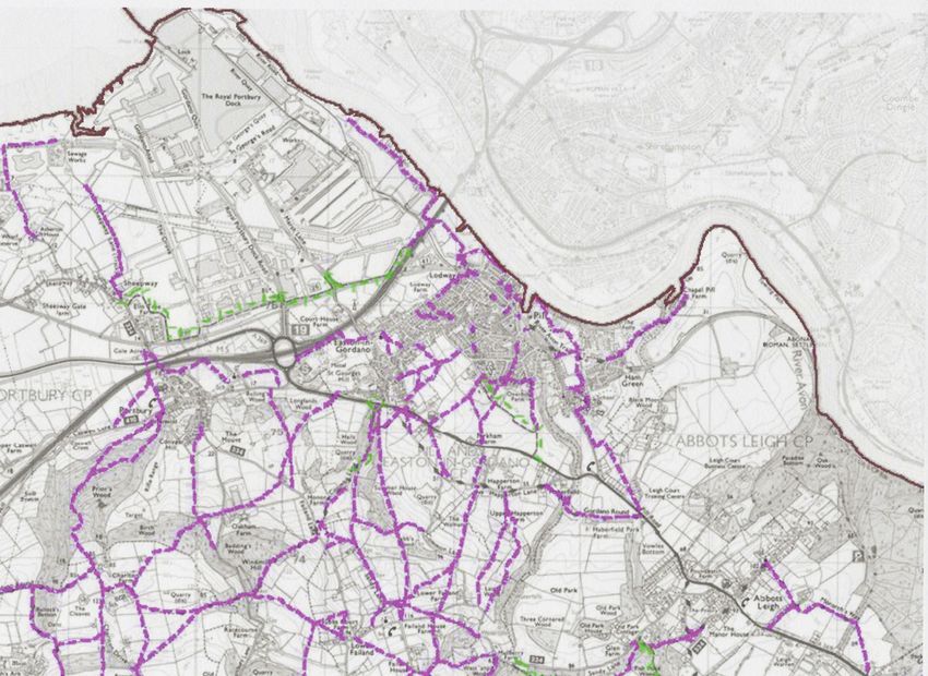
Map 1 Neighbourhood Plan Area

Abbots Leigh, Ham Green, Pill and Easton-in-Gordano   | 7

4 VISION, PRINCIPLES, OBJECTIVES
  AND POLICIES
4.1      Organisation of the Plan

The Neighbourhood Plan is based on a simple           the issues facing the community are covered
Vision behind which lie a set of three Principles     in a set of Background Papers. These papers
which acknowledge that the Plan must reflect          inform a set of Objectives followed by Policies
and respond to the past, the present and the          and Development Proposals which are the key
future. Detailed description and analysis of          component of the final Plan.

                                               VISION
                   A distinctive, stable and sustainable neighbourhood meeting
                          local needs and promoting strong communities

        PRINCIPLE 1                        PRINCIPLE 2                      PRINCIPLE 3
        PROTECTION AND                 RESILIENCE AND CHANGE                  COHESION AND
           CONTINUITY                  Flexibility for a sustainable         COLLABORATION
        Valuing the past –               future – recognition of            Working together to
    protection, enhancement             change and challenge in            reinforce community
       and sustainability of              the coming 20 years             identity and ensure the
    heritage and environment                                                social and economic
                                                                          inclusion of individuals,
                                                                        families and communities

                                  BACKGROUND PAPERS
           HOUSING               TRANSPORT               ENVIRONMENT             HERITAGE

                      ECONOMY              CLIMATE CHANGE              COMMUNITY

                                           OBJECTIVES

                   POLICIES AND DEVELOPMENT PROPOSALS

                             THE NEIGHBOURHOOD PLAN

8   |   Neighbourhood Plan 2020-2026
4.2   Primary Objectives

The primary objectives of the Plan are

       • Contribute to meeting local housing need through a mix of tenure, size
         and affordability.

       • Minimise the impact of road traffic on congestion, parking, safety, and
         pollution.

       • Encourage walking and cycling and ensure the accessibility, convenience
         and safety of cycle and walking routes.

       • Sustain and enhance the landscape, ecology and biodiversity of the area
         whilst protecting its environmental assets.

       • Respect, preserve and protect the history and the heritage of the built
         environment.

       • Support the generation of local job opportunities for local people.

       • Respond to climate change and move towards a carbon neutral
         neighbourhood.

       • Protect, maintain and enhance Open Spaces, Rights of Way and pathways
         for walking and cycling.

       • Celebrate and sustain the strengths, cohesion and inclusion of the diverse
         communities of the area.

We recognise that these objectives may pull    conservation, new development may
in different directions and may sometimes      create traffic and fail to encourage walking
appear contradictory. Not all the primary      and cycling. There have therefore been
objectives can be met across the whole         compromises which we hope our local
Neighbourhood Area. Meeting housing            communities will recognise and accept.
need may conflict with environmental

                                           Abbots Leigh, Ham Green, Pill and Easton-in-Gordano   |   9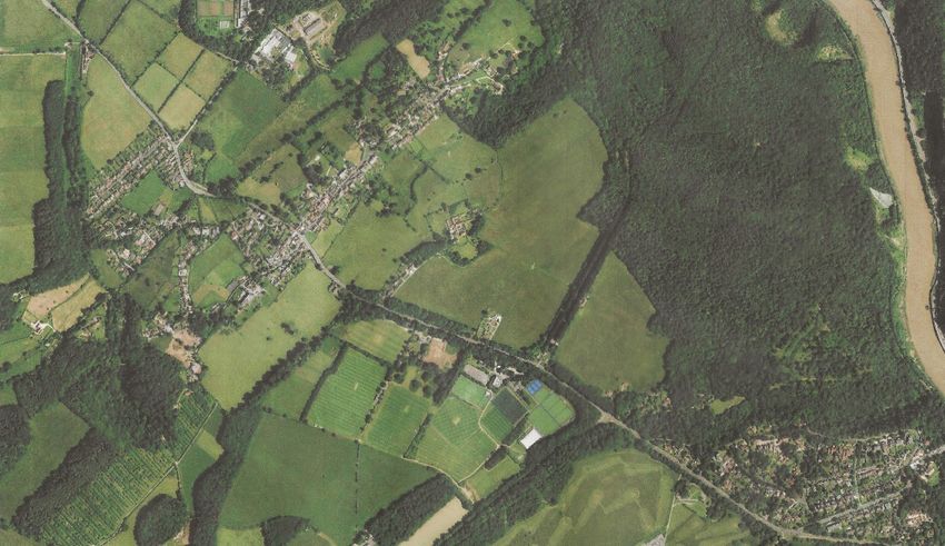
5 HOUSING (See also Background Paper 1)
                                                                and similar age distributions. The whole area
     Primary Objective                                          was predominantly ethnically white with a
                                                                population largely born in the UK.
     Contribute to meeting local housing
     need through a mix of tenure, size and                     In 2011 there were 2,416 households.in
     affordability.                                             occupied dwellings, occupying 96.8% of
                                                                the total dwelling stock. 80 dwellings were
                                                                unoccupied (3.2%). 63 dwellings were over-
5.1 Background3                                                 occupied. In Abbots Leigh 93% of dwellings
                                                                were in detached or semi-detached
In 2017 the population of the Neighbourhood                     houses, by comparison with Pill & Easton-
Plan Area (NPA) was 5,698 of whom 88%                           in-Gordano where 67.5% were in houses
lived in Pill & Easton-in-Gordano parish and                    and 29.6% in flats or terraces. Ownership
12% in Abbots Leigh parish. The population                      was the dominant tenure throughout
of Pill & Easton-in-Gordano had grown                           (89% in Abbots Leigh, 76% in Pill & Easton-
slightly since 2001 whilst that of Abbots                       in-Gordano) with some private rented
Leigh had declined slightly. Abbots Leigh had                   throughout the area. Social renting was at
a greater proportion of women and older                         7% in Pill & Easton-in-Gordano (and zero in
people. There were similar proportions of                       Abbots Leigh).
male and female residents in each parish

5.2        Household Growth

The Neighbourhood Plan Area is dominated                        see Map 2) are surrounded by Green Belt, as
by the Green Belt. The whole of the parish                      is Royal Portbury Dock.
of Abbots Leigh and the more recent St.
Katherine’s Park estate at Ham Green lie                        Pill & Easton-in-Gordano parish - 9 sq.km
within the Green Belt. The built areas of Pill                  including 6 sq km of Royal Portbury
& Easton-in-Gordano (the Pill Settlement –                      - is geographically constrained and

                          Map 2 Pill Settlement Area

3     This section draws on the National Statistics Office 2011 Census and 2017 population estimates.

10    |   Neighbourhood Plan 2020-2026
concentrated. 96.7% of the parish population houses in Ham Green. The proportion of
(4,478 residents) and 92.4 of the households parish population living within the main
(1,947 households) lived within the Pill body of the village is 55% (households 61%).
Settlement boundary. (see Map 2).
Between 2007 and 2017 completed
Within the Green Belt itself growth has been development sites within the Settlement Area
heavily constrained. Abbots Leigh parish of Pill & Easton-in-Gordano produced 60 new
(9.13 sq.km) lying entirely within the Green dwellings.4 In Abbots Leigh the figure was 5
Belt, has no formal settlement boundary new dwellings within the village.5 Residential
and is a much larger, more rural parish than expansion outside, but adjacent to the Pill
Pill & Easton-in-Gordano with a number of and Abbots Leigh settlements produced only
outlying areas beyond the village – Home a further five dwellings across the whole
Farm Road, Ashgrove Avenue, Blackmoor Neighbourhood Area - a reflection of the
Road, parts of the Pill Road and a few stringent application of Green Belt policy.
5.3 Housing Demand and Provision
There has been a recent tendency for and the attractiveness of Pill, traditionally a
existing owners to extend rather than less appealing location, has risen sharply in
sell property and many local planning the last couple of years. Pill was described
applications seek improvements and to us as ‘on the up’. Abbots Leigh has the
extensions – sideways or upwards. strongest links to Bristol, and housing at
Nevertheless there is strong housing demand Ham Green sells quickly. In part this level
throughout the Neighbourhood Plan Area. of housing market buoyancy in the NPA is
Developers believe that housing supply because there is relatively little movement
in North Somerset is insufficient to meet out – Pill has a strong sense of identity and
current housing targets and there have been community with many families keen to
speculative proposals both for major (1,000 remain, even if not in the same property.
dwellings) development projects at Chapel There is nevertheless movement in from
Pill, Martcombe, and St. George’s Hill (now Bristol and Portishead. The proposed
sometimes referred to as Plummer’s Hill) and Portishead rail line, with a station at Pill, is
at other smaller sites where landowners/ moving ahead with a planning Development
developers hold land with hope value. Consent Order submitted to Government in
late 2019. Already this is thought to be giving
Interviews with Portishead estate agents impetus to the housing market.
confirm there is an active housing market
5.4 Affordability and Housing Need
There have long been concerns about the amounting to 2.9% of all dwellings) and
availability of affordable housing for local the number of bedrooms (945 dwellings,
people in Pill and Easton. There is some amounting to 2.1% of dwellings). There are
over-occupation as measured by both the significant numbers of households with
number of rooms (63 rooms, dependent children and children under 4.
4 North Somerset Council: Parish Profiles:2017 Pill and Easton-in-Gordano
5 North Somerset Council: Parish Profiles:2017 Abbots Leigh
Abbots Leigh, Ham Green, Pill and Easton-in-Gordano | 11Pill West is the 35th most deprived LSOA6 2521 questionnaires were distributed to
in North Somerset, being the only area in all households in both parishes. 724 were
North Somerset outside Weston-super- returned (28.4% response rate).
Mare lying within the most deprived 40%
in England. On more detailed deprivation Key findings were:
indicators - low income, employment,
education and skills, health and disability - • 29 respondents were unable to buy or
Pill West scores relatively highly as it does rent in the open market
on income deprivation focussing explicitly • 10 additional respondents could not afford
on children and on older people. to buy a shared ownership property
• 2 respondents over the age of 55 could
Alliance Homes are the main providers not afford to buy/rent in the open market
of affordable housing, providing mainly • A further 10 households could afford to
social rented accommodation (former local meet their need in the open market
authority stock). They hold 297 properties, • 50 of the above respondents met the
many in the neighbourhood around Victoria local connection criteria
Park and the Creek in Pill. Curo, LiveWest • 71% of all respondents were in favour of a
(formerly Knightstone Housing) and Sovereign small development of affordable housing
Housing are also registered providers who for local people.
hold small developments in Pill.
Of the 29 households identified as being in
In order to provide more evidence on housing need 9 would have a need within
housing need Pill and District Community twelve months, 12 within 2-3 years and
Development Trust,7 in conjunction with 8 within 3-5 years. 15 homes would be
North Somerset Council, conducted a needed for single people or couples. 9 two-
housing survey in autumn 2016. The aims bedroom homes were needed for families
of the survey were to give an indication and 5 three-bedroom homes were needed
of the affordable housing need in terms also for families.
of tenure and house size for people with
a local connection in the two parishes, to The Survey Report is available in full on the
investigate the housing need and aspirations Neighbourhood Plan website at
of older residents in the parishes, and to www.pillanddistrictplan.org
establish the general level of support for a
small development of affordable housing for
local people with housing needs.
5.5 Neighbourhood Area Housing Strategy
The North Somerset Local Plan 2038 will site, and reconsideration of the Green Belt
provide a longer-term framework for and its boundaries. There will certainly be
development covering the years 2023-2038. a revision of the housing numbers required
The Plan may cover issues such as the of North Somerset, expected to increase to
introduction of a settlement boundary for around 1,700 dwellings a year.
Abbots Leigh, updating the Pill Settlement
boundary to include the housing built on In order to underpin their strategic thinking
and around the former Ham Green Hospital about the possible scale of future growth
6 Lower Super Output Areas (LSOAs) are the smallest area for which deprivation information is calculated
7 The Pill and District Community Land Trust (PDCLT) was set up in 2017 under the Housing and Regeneration Act 2008
12 | Neighbourhood Plan 2020-2026and provide a realistic context for their but would threaten biodiversity and the
thinking the Neighbourhood Plan Steering ecological framework of the Area, would
Group assessed a range of hypothetical exacerbate peak hour traffic congestion
longer-term housing scenarios. Three and overload on both the A369 and the Pill
scenarios were tested: Loop, would threaten environment and
biodiversity, would create further pollution
• Minimal growth - retaining tight control and would hinder attempts to address
of new development, maintaining the climate change. In short this scenario is both
Green Belt and accepting only infill and/or damaging and unsustainable. Whilst the Joint
‘exceptional’ new projects. Spatial Plan is now redundant it concluded
• Medium growth - allowing limited that the Easton in Gordano/Pill corridor
growth in the order of 100-150 new was ‘a very constrained location in terms of
dwellings – mainly in clusters around the transport, Green Belt, heritage, landscape
edges of Pill and Abbots Leigh with minor and ecology.10 Expansion of this scale would
adjustments to Green Belt boundaries. increase the number of households in Pill
• Major growth - development of up & Easton-in-Gordano by 50% and would
to 1000 dwellings making a major radically damage the social patterns of
contribution to North Somerset housing community life.
supply. The proposed development
known as ‘Pill Green’ was used to test Community opinion on the three scenarios
this scenario.8 was tested both at public exhibitions in
autumn 201911 and in Regulation 14 local
An analysis of these scenarios is provided consultation in April-September 2020.
in Background Paper 1. The Neighbourhood
Plan Steering Group, in consultation with At the Exhibitions 35% of the 210 local
the two parish councils and the local residents attending favoured Scenario 1 -
community, considered that: minimal new development. 61% favoured
Scenario 2 – medium growth. Only 4%
Scenario 1 made a minimal contribution welcomed Scenario 3 – major growth of
to meeting North Somerset housing need 1000 dwellings.
and would rely exclusively on infill and/or
‘exceptional’ sites. Local Consultation confirmed these
preferences - retention of the bulk of the
Scenario 2 - the development of 100- Green Belt, provision of affordable housing
150 dwellings in small clusters of housing and small-scale local development.
of around 20-30 dwellings adjacent to The possibilities of major development
existing settlements would retain the bulk schemes of up to 1000 dwellings put
of the Green Belt, would offer a modest forward by developers were universally
contribution to the housing needed in unwelcome to residents.
service villages and other settlements and
would offer close linkage with existing local Results from the 2016 Housing Survey
services in Pill. provided both evidence of housing need and
(71%) a preference for a small development
Scenario 3 not only runs counter to Green of affordable housing. Whether the survey
Belt and Landscape Quality policies,9 remains up to date was checked with North
8 Consultation Comment 15796321/2 submitted to the West of England Joint Spatial Plan Examination by Barton
Willmore on behalf of Gallagher Estates
9 North Somerset Council. Landscape Sensitivity Assessment, 2018 pp 45-47
10 Joint Spatial Plan: Towards an Emerging Spatial Strategy, October 2016, Table 2
11 The Exhibitions are described in the separate Consultation Statement
Abbots Leigh, Ham Green, Pill and Easton-in-Gordano | 13Somerset Council and the survey results Somerset, the Steering Group considered
were found to be still valid. that a slightly larger dwellings target was
more realistic. Scenario 2 was adjusted,
This evidence led the Steering Group therefore, to suggest 150-200 dwellings
to confirm that Scenario 2 was the by 2038 provided in clusters of up to 20-
best option because, in the light of the 30 dwellings. The evidence also led the
most recent estimates of the levels of Steering Group to confirm that Scenarios 1
dwellings likely to be required in North and 3 were unacceptable.
5.6 Proposals 2020-2026
Whilst the three scenarios were developed New Development The Neighbourhood Plan
to assist strategic thinking and provide a Steering Group, in collaboration with the Pill
long-term context, particularly relevant and District Community Land Trust, identified
given that the North Somerset Local Plan a number of potential sites that could meet
2038 is under way, the Abbots Leigh, the need for a cluster of affordable housing.
Ham Green, Pill & Easton-in-Gordano Nine sites were considered (see Map 3 on
Neighbourhood Plan covers only the years page 14).
up to 2026. The housing targets established
for this period in the Core Strategy 2017 • The former Pill Baptist Church
required 2,100 dwellings for service villages • Land off the main road at Ham Green
(including Easton-in-Gordano/Pill) and
985 for other settlements and countryside These two sites lay within the Pill Settlement
(including Abbots Leigh). Specific targets for boundary but were severely constrained in
individual parishes were not specified but terms of access, size, legal and construction
with the Neighbuorhood Area being largely obstacles, and feasible housing type. The
Green Belt little, if any, growth was built into remaining six sites lie in the Green Belt, just
the 2017 Strategy. outside the Pill Settlement boundary.
In the period to 2026 housing possibilities • Land at the top of St. George’s Hill
in the Neighbourhood Area are limited (sometimes referred to as Plummer’s Hill)
by the Green Belt (CS 6), and the status of • Land off Marsh Lane (lower Plummer’s Hill)
Abbots Leigh as a ‘rural’ parish (CS,16, 32). • Land off Cross Lanes (beside the
Nevertheless, the Neighbourhood Plan offers allotments)
a planned increase in the supply of housing • Land adjacent to St. Catherine’s Mead
units of fifty-five (55) by 2026 together with • Land off the A369 beyond St Katherine’s
re-use of a largely derelict brownfield site. School
• Land at Orchard View/Somerset Lodge
Infill There is scope for some limited • Land off Chapel Pill Lane/Hayes Mays Lane
residential infill within the Pill Settlement
boundary together with the possibility of On the first four of these latter sites, all the
residential gain in Abbots Leigh through landowners held strong ‘hope value’ views
the adaptation or conversion of agricultural and were unwilling to consider a sale to
buildings.12 Together with windfall sites the Land Trust. Land beyond St. Katherine’s
across the Neighbourhood Area this might School was thought to be both Green Belt
produce in the order of fifteen (15) new and too far from existing services. The land
dwellings by 2026. at Orchard View, not in single ownership
12 NSC Development Management Policies DM 45
14 | Neighbourhood Plan 2020-2026Baptist Chapel
Orchard View
Marsh Lane
Chapel Pill Lane
Cross Lanes
St. George’s Hill
Pill Road
St. Catherine’s Mead
A 369
Map 3 Community Land Trust Search for sites
at the time, was too constricted to allow development of around thirty (30) mixed
a viable development. A further site – tenure housing comprising both market
Brookside – was also considered but, lying and affordable housing, together with a
in the Green Belt and important for play and sixty-bed care home.
recreation (see Chapter 11), was rejected by • AFFORDABLE HOUSING: A one-and-
the Steering Group. Two potential sites were a-half-acre exception scheme of up to
identified in Abbots Leigh but the primary sixteen (16) affordable housing units to
need for affordable housing is in Pill and the rent on Chapel Pill Lane in the Green
Land Trust recommended that Abbots Leigh Belt (proposed by the Pill and District
was not a priority for its first development. Community Land Trust).
Chapel Pill Lane was well located and the It should be noted that the provision
only site where the landowner was willing of a 60 bed care home would release
to engage and sign terms of agreement. accommodation elsewhere in North
The whole of the brown field site at Somerset and beyond and hence making a
Orchard View/Somerset Lodge has since further contribution to meeting housing need.
come into single ownership and offers the
potential for mixed-use redevelopment Both these sites lie within Ham Green (see
within the plan period. Map 4). The former Ham Green Hospital site
has been redeveloped to become the Eden
For the period to 2026, therefore, the Plan Business Park, the St Katherine’s Housing
allocates two new development sites in Estate and the Penny Brohn Centre. The
Ham Green which would offering a further majority of Ham Green remains outside the
forty (40) new dwellings in the Plan Area by Pill Settlement boundary and within the
2026 (see map 4): Green Belt.
• ORCHARD VIEW: a 3-acre brownfield site
at Perrett Way in Ham Green for a mixed
Abbots Leigh, Ham Green, Pill and Easton-in-Gordano | 15Orchard View
Chapel Pill Lane
Map 4 Ham Green
5.7 Improvement Area 1
Improvement Area 1 Orchard View Pill Community Orchard and is the final
undeveloped part of the former Ham Green
This proposal brings together what were Hospital complex (see Map 5). In addition
formerly two separate care units owned by to the two main buildings there are some
the North Bristol NHS Trust until Ham Green outbuildings. The whole site is now in
Hospital was closed in the 1950s. Sold to the single ownership and the owner is keen
Milestones Trust, Somerset Lodge became to redevelop it into mixed-use – twenty-
a 35-bed dementia and mental health care four market and rental housing dwellings
home, whilst Orchard View was until, 2010, (including an affordable housing element)
an Intermediate respite care unit. plus a new and up to date care home with
sixty beds and a staff of sixty. Up to sixty jobs
Located on Perrett Way, the site is would be created, many for local people.
bounded by Eden Business Park and the The intention would be to build smaller units,
Map 5 Orchard View
16 | Neighbourhood Plan 2020-2026including some apartments, at a range of size whom there are no local facilities. There
and cost. New housing provision might be up is a walk past the community orchard on
to thirty (30) dwellings incorporating some Watchhouse Hill down to Pill centre (a section
affordable housing. of the River Avon Walkway). The hill is a hugely
popular leisure/recreation site and a small
The site is in the Green Belt and outside the café would attract a number of walkers.
(now outdated) Pill Settlement boundary.
It is within walking distance of Pill Precinct As yet there are no design plans, and only
and there is a bus stop and pub at the end informal discussions have been held with the
of Macrae Road. It has easy access to St. planning authority. This is an already developed,
Katherine’s School. The site is unoccupied brown field site and the proposal is for a
(other than as a temporary rental at continued health and social care use. The
Somerset Lodge) and the buildings are run- proposal addresses housing need and demand,
down and dilapidated (see below). and might have additional value in so far as
long-term care home residents moving to the
There could be a small café/shop for care home might release other local dwellings
residents, visitors to the home, local residents into the housing market. The scheme would
and employees on Eden Business Park for also offer significant local job opportunities.
5.8 Improvement Area 2
Improvement Area 2 Affordable Housing and offers an outlook over open ground
and across to the Leigh Court Estate. The
Recognising the need for affordable housing, development would make joint use of a
the PDCLT Board has, between 2017-2019, new MetroWest entrance adjacent to Hayes
been seeking sites for affordable housing Mays Lane to be constructed to give access
and engaging in discussion with landowners to the Portishead rail tunnel which runs
about their willingness to collaborate with beneath St. Katherine’s estate.
a PDCLT project. Subject to final agreement
with the owner and planning approval, a site Although there is some existing housing on
of one and a half acres has been identified Chapel Pill Lane and Hart Close, the proposed
lying between Chapel Pill Lane and Hayes development would be well screened by
Mayes Lane. (see Map 6 on p17). trees and could not be seen from nearby
housing. Penny Brohn UK, a national cancer
The site is on sloping ground falling down care centre, lies on the opposite side
towards Ham Green Lake (a Wildlife Site of Chapel Pill Lane and again would be
and a Site of Nature Conservation Interest) screened by trees on both sides of the lane.
Abbots Leigh, Ham Green, Pill and Easton-in-Gordano | 17Map 6 Chapel Pill Lane (Site plan and aerial view)
The one and half acre development would site amounts to around 450 motor vehicles
consist of up to 16 dwellings offering on a weekday (200 on weekend days) with
a mix of one, two and three-bedroom the heaviest traffic at morning and evening
units. The precise number would depend peaks. Traffic serves Chapel Pill Farm and
on final negotiations on land purchase, Rock Cottages on the lane as well as Penny
timing of the MetroWest access road, and Brohn where car parking for 80 cars is full
available grant for housing and consequent throughout the day. The lane is also well used
affordable rents. The housing would be by cyclists and walkers but the proposed
provided (built and managed) through a development site is privately owned with no
partnership of PDCLT and Alliance Homes public access. Ham Green Lake is a private
and would offer affordable housing to fishing lake to which local walkers have
households with a local connection. A local access with the permission of the owner.
allocation process has been developed to Hayes Mays Lane is an old track which comes
ensure that the new development would to a dead-end above the entrance to the
meet these requirements. rail tunnel which runs through to Pill. The
proposed development site is within reach
There is a path past the community orchard of local services at Pill Precinct and is close
on Watchhouse Hill down to Pill centre and to St. Katherine’s School. Pedestrians would
there is a bus stop at the end of Macrae access services either through Chapel Pill Lane
Road. Although formally not open to motor or a dedicated pathway from the bottom
vehicles other than residents, traffic on Chapel of the site and up Hart Close and thence via
Pill Lane below the proposed development Watchhouse Hill to the Precinct.
18 | Neighbourhood Plan 2020-2026The proposed Chapel Pill Lane development site
Both development proposals (Section 5.5 consultation, reported in the Consultation
above) are close to important heritage Statement, demonstrated considerable
and environmentally important sites at Pill local opposition to the Chapel Pill Lane
Community Orchard and Ham Green Lake. development, but on balance two thirds (65%)
Any threat to landscape can be addressed of the 130 respondents expressing a view
sensitively to preserve heritage vistas through were in favour of the scheme.
appropriate screening and tree-planting. Local
5.9 Housing Design
Whilst the volume and location of new The Core Strategy is reinforced in NSC
development is important, so also is the Development Management Policies
quality of new housing in terms of energy which highlight the importance of place
efficiency, building design, safety and local making, accessibility, housing mix and
environment. The National Planning Policy density.16 Design of the built environment
Framework stresses the importance of should be sympathetic to local settings
well-designed places and we endorse its and landscapes. Where there is historic or
recommendations.13 North Somerset Council heritage value in, for example, traditional
Core Strategy also emphasises both that buildings, conversion may be inappropriate.
‘quality design should be accorded priority if In the two proposals for development
places are to be shaped as sustainable, and in this Plan emphasis should be given to
socially, economically and environmentally environmental amenity - tree planting,
responsive’.14 ‘New development, both water run-off, wildlife habitats. Planning
residential (including conversions) and applications for new development should
non-residential, should demonstrate a be required to include proposals for
commitment to sustainable design and management and maintenance of the
construction. In relation to climate change, immediate and surrounding environments.
increasing energy efficiency through design,
and prioritising the use of sustainable low There is a growing incidence both in
or zero-carbon forms of renewable energy the more rural parts of the area but also
generation are all important objectives.15 within Pill of the conversion to residential
use, often without recourse to planning
permission and often of poor design
13 National Planning Policy Framework. Section 12, paras 124-127
14 North Somerset Council, Core Strategy CS 32
15 North Somerset Council, Core Strategy CS 2
16 North Somerset Council, Development Management Policies DM 32, 33,34, and 36
Abbots Leigh, Ham Green, Pill and Easton-in-Gordano | 19quality, of stables, outbuildings etc. Where local character and avoids inappropriate
this is ‘infill’ it may damage the character design. Conversion of non traditional
and appearance of neighbouring buildings. barns and utilitarian shelter structures
Where it takes the form of the conversion to residential uses should be exempted
of an existing barn or other outbuilding it from a Permitted Development status that
needs to be done in a manner that respects currently exists in North Somerset.
5.10 Policies
Existing North Somerset Core Strategy HO 4 Infill development in keeping with
and Development Management Policies local scale and character will be acceptable
already in place address the Green Belt within the Pill Settlement boundary.
(CS 60), High Quality Design and Place
making (CS12), Affordable Housing (CS16), HO 5 Planning applications for new
Rural Exception Schemes CS 17), Healthy development should be required to include
Living (CS 26), Quality Design (DM 32) and proposals for the sustainable management
Care homes (DM 41), Conversion of rural and maintenance of the immediate and
buildings to residential use (DM 45). surrounding environment.
Policies HO 6 Restrictions should be placed on
the conversion for residential use without
HO 1 Site A (Orchard View as shown on Map planning permission of outbuildings within
5) is allocated for a Care Home and thirty the curtilage of a main dwelling.
(30) houses.
Community Action
HO 2 Site B (Chapel Pill Lane as shown on
Map 6) is allocated as an exception site of CA/HO 1 The Parish Councils should encourage
up to sixteen (16) affordable housing units. and stimulate improvement of the energy
efficiency of the existing housing stock.
HO 3 (also CC 03) New development should
be conditional on an energy assessment
which minimises carbon footprint and
energy requirements.
6 TRANSPORT AND MOVEMENT (See also Background Paper 2
Transport and Movement)
This Chapter was informed by a
Primary Objective
consultancy study commissioned from
the Peter Evans Partnership, Bristol, whose
Minimise the impact of road traffic on
full report is included as an appendix to
congestion, parking, safety, and pollution.
Background Paper 2.
Encourage walking and cycling and
ensure the accessibility, convenience
and safety of cycle and walking routes.
20 | Neighbourhood Plan 2020-20266.1 Background
Movement within the Neighbourhood Plan itself there are concerns about the volume of
Area is dominated by the A369 bisecting the traffic through the village, as well as anxieties
area from the edge of Bristol to the M5. There about parking and safety. Feeding into both the
are major community concerns about the A369 and the Pill Loop run a number of side
traffic associated with this busy trunk road roads and lanes, many narrow and twisting.
- volume, speed, pollution and safety. Also Motorised traffic is the largest worry for
important is the Pill Loop, running from the residents, but there is growing commitment to
Haberfield junction on the A369 and rejoining walking and cycling and there are high hopes
at St. George’s Hill close to the M5. Within Pill for the re-opening of the Portishead rail link.
6.2 Traffic Volumes
The A369 is heavily loaded and congestion School towards Bristol with around 30%
occurs at peak times. A local resident-led then taking a right turn to Martcombe
survey in October 2018 showed total daytime and the remainder joining the A369 traffic
traffic flow into and out of Bristol amounting towards Bristol. Roughly the same number
to around 17,000 motorised vehicles (2,190) leave the A369 to go into Pill past
(excluding bicycles). Flow in off-peak day- St. Katherine’s School. Cars are dominant
time hours varied, but on average amounted throughout the day (84%) and even more
to 71% of peak hour flow. Both the daily flow so at peak hours - 77% towards Bristol, 88%
and the peak and off-peak split figures are towards Pill, a balance in part explained
broadly consistent with North Somerset by the school run in the morning to St
Council figures which suggest a typical split Katherine’s School.
of 60% off-peak. Peak-hour traffic into Bristol
accounted for 22% of all daytime traffic. At St George’s Hill 2,356 vehicles a day leave
12-hour daytime traffic is estimated to have Easton-in-Gordano to join the M5 whereas
made up 81% of all 24-hour traffic. a slightly larger number (2,539) leave the
A369 to enter Easton-in-Gordano. (the
Cars dominated traffic volumes, amounting disparity is probably as a result of the one
to over 80% both through the day and way exit from Easton onto the A 369 via
at peak hours. Heavy Goods vehicles Rectory Road). By contrast with the main
flowed throughout the day – around 220 A369, the volume of traffic is spread more
in each direction but making up only 2.5% evenly throughout the day. The volume and
of all traffic. By contrast vans - 1440 a speed of traffic – especially heavy lorries
day towards Bristol and 1210 outwards - - creates major anxieties at a number of
comprised 15.5% of all traffic. points, with the Sandy Lane/Leigh Court
junction on the A369 identified in local
On the Pill Loop over two thousand (2,105) consultation as a major danger point.
vehicles per day passed St. Katherine’s
6.3 Traffic Growth
Not only are the current levels of traffic but further growth seems likely. The latest
causing some congestion at peak hours, draft Joint Transport Plan17 suggests that
17 West of England Combined Authority. Joint Transport Plan. January 2020
Abbots Leigh, Ham Green, Pill and Easton-in-Gordano | 21without major change the most likely in and around the Neighbourhood Plan local outcomes by 2036 are vehicle trips Area over the next seven years18 although up by 26%, CO2 emissions up by 22%, and due to COVID-19 and lockdown the level congestion costs running at £800m a of homeworking has increased and traffic year. The removal of tolls on the Severn levels have dropped. Nevertheless further Bridges and/or the opening of the South increases in peak-hour congestion should Bristol Link together with growth at Royal be avoided. Portbury Dock may influence traffic levels 6.4 Method of Travel Throughout the Neighbourhood Plan Neighbourhood Area and probably have Area over seventy per cent of journeys to work journeys of less than 2 kilometres.19 work are by car or van either as driver or Some Pill residents also make long journeys, passenger, 7% by foot or bicycle, 3% by bus although half of the journeys to work from with 10% working at or from home. Travel Pill/Easton residents in employment are to to work is dominated by use of car or van. Portishead, nearby villages and Avonmouth. Around a fifth of residents work within the 6.5 Safety The Neighbourhood Plan Area is not a high cross the main road from side roads and/or accident area,20 but despite the relatively cycle paths. small numbers of accidents reported there are fears in the community about speeds In Pill there have been concerns about a on the A369 and the risk of accidents. number of danger points on narrow streets/ These are most severe at junctions, where lanes and/or where visibility is poor. In the the majority of accidents occur, notably 2006-16 Parish Plan for Easton-in-Gordano, junctions on the A369 and the several side Pill and Ham Green there was support for a roads joining between the Beggar Bush one-way priority system and for a safety rail Lane and the M5 motorway.21 In particular on the raised footpath at Lodway. A more there are major concerns about the risk recent local transport survey (late 2019) to cyclists as they cross side-roads and demonstrated that there was continuing private entrances when on the cycle path support for a 20 mph. speed limit within the (for example, the exit to the Clifton College Pill & Easton-in-Gordano parish (a wish that sports ground) and when they join and has recently been agreed). 6.6 Parking Parking is also one of the issues which around Victoria Park. These would be an has emerged in discussions about the Pill important element in planning the future Precinct and potential improvements to of the Precinct. The local transport survey parking arrangements e.g. on Pill Street and endorsed tighter parking policies in Pill – 18 See Chapter 9 below 19 Neighbourhood Plan Background Paper 2, Para 2.6-2.7 20 Neighbourhood Plan Background Paper 2, Para 2.8 21 Police accident data provided by North Somerset Council 22 | Neighbourhood Plan 2020-2026
double yellow lines (64% in favour), time                      on pavements and verges. Parking on
limited parking (56%), more enforcement                        pavements obstructs pedestrians especially
(69%). There was mixed support for a                           those with prams or pushchairs. Verges are
residents parking scheme in some areas                         often a protection for pedestrians but also
(40% for, 33% against). Elsewhere there is                     offer important habitats for insects or small
likely to be a spillover demand for parking                    mammals. They can also be useful play
space as a consequence of the opening of                       spaces for young children.
the rail station.
                                                               Generally there is a tension between those
In Abbots Leigh current parking difficulties                   who want access to parking to be limited
have arisen in Church Road and Manor Road                      and others wanting it to be made easier,
as a consequence of the combination of the                     a tension evident from local consultation
re-opening of the George Inn, the opening                      responses to the Plan in relation to Pill on
of a Fitness Gym behind the Village Hall,                      Macrae Road and to Abbots Leigh on Church
and the more frequent presence of delivery                     Road. Throughout the area there is also
vans. Improvements to traffic management                       tension between motorists – parking on
and parking arrangements in the village                        pavements – and pedestrians obstructed by
need to be considered as a distinct issue                      parked cars. It is particularly in the interests
- closely related to, but distinct from, the                   of those walking with pushchairs or buggies
possibilities of a Conservation Area (see                      that pavements should be kept clear.
Chapter 8 Heritage).                                           Finally there is tension between those who
                                                               concrete over gardens to provide parking
Clear verges help to provide safe walking                      space and those who wish to see all green
routes. Throughout the Neighbourhood                           space around dwellings protected.
Area there is a growing incidence of parking

6.7      Capacity, Overload and Congestion

Through Abbots Leigh at the George Inn,                        side and a pedestrian walkway (without
the A369 is congested and traffic flow                         railings) on the other only two cars can
constrained at peak hours and to a lesser                      pass and on-site observation provides
extent through the day. The road has                           evidence that the road is on occasions
frontage access, side roads, bus stops, and                    in practice one way.23 The frequent
an at-grade pedestrian crossing. The speed                     misdirection of heavy vehicle bound for
limit is now 30 mph. Heavy vehicles/buses                      Royal Portbury Dock creates unwelcome
are often unable to pass each other. Up                        traffic through Easton-in-Gordano.
the Pill Road and towards Martcombe the
road is heavily used and at St. George’s Hill                  There is much cycle movement on the A369
traffic flow is limited by the provision of a                  and cycle and pedestrian movement within
T-junction traffic light control.                              Pill on the Pill Loop. Residents are hindered
                                                               by the frequency of the traffic both within
The Pill Loop creates resident concern at                      Pill, and especially at the Precinct and in
the Precinct and the narrow part of the                        Abbots Leigh where crossing from Manor
Loop at Lodway has been a concern for                          Road to Church Road and vice versa is
years.22 Technically the road width allows a                   hazardous.
car and lorry to pass, but with walls on one
22    The 2006-26 Parish Plan for Easton-in-Gordano, Pill and Ham Green highlighted major traffic concerns, and a recent
      2019 local survey called for a 20mph speed limit in the parish
23    PEP consultants observed traffic flows as part of their work for us

                                                        Abbots Leigh, Ham Green, Pill and Easton-in-Gordano         |   23
6.8 Pollution
The main pollutant measured by NSC to April inclusive, however, the level of air
locally is nitrogen dioxide (NO2) originating quality was above 30.0 and reached 45.1,
primarily from road traffic emissions. again the third highest level for any month
There are two monitoring sites in the across the whole district.24 Increases in
Neighbourhood Area – in Pill at the end of road traffic emissions should be avoided.25
Avon Road (the Railway Line) and at the Concerns were expressed in consultation
junction of the A369 and the Pill Road (the that air pollution levels around the M5 and
A369). At the A369 site the mean annual Junction 19 were severe and that monitoring
level was 28.0 – the third highest annual should be extended to give better coverage.
level in North Somerset. From November
Cycling and Walking
6.9 Cycle Networks
A shared-use traffic free path runs alongside Port of Bristol. The route is unsurfaced and
the A369 from Bridge Road in Leigh Woods unlit and is very poorly maintained so that
all the way to the road into Pill at Ham in wet conditions it has become almost
Green. The section to the George in Abbots impassable in places. Nevertheless this offers
Leigh has been designated as National a level access into Bristol and is popular as
Cycle Route 334 and following Manor Road, both a commuting and recreational route.
past Abbots Pool and then Sandy Lane this Due to lack of maintenance, however, its
continues to Lower Failand and Portbury. condition has deteriorated so much that
This cycle path attracts both commuter it is now almost impassable in places and
riders to Bristol but also recreational cycling, needs significant repair works. National Cycle
accessing, for example, Leigh Woods, Abbots Route 26 branches off Route 41 before the
Pool and Snake’s Well. There are several side Avonmouth Bridge and goes through Royal
entrances and ‘give way’ markings which Portbury Dock to Sheepway and Portishead.
slow down and deter hardened cyclists. As
a result and despite the poor quality of the The 2011 Census shows that only 7.4%
road surfaces in some places, some cyclists of Neighbourhood Area residents in
choose to cycle on the main road because it employment travelled to work by bicycle
is quicker even if it slows down traffic flow. (199 cyclists). Since then the numbers
choosing the bicycle as a means of travel
The cycling and walking National Cycle – to work and elsewhere – has risen
Route 41 (using part of the Avon Trail) runs significantly. Cycling has become more
along the towpath beside the River Avon popular, cycling has become safer, the cycle
through the Avon Gorge to Chapel Pill, through path beside the A369 has made travel to
Watchhouse Hill and Pill and then connects and from Bristol more acceptable.
to the cycle route on the Avonmouth Bridge
across the river. One section of this route lies Cycling numbers measured at the
within the boundary of Bristol City Council, four cycling census points within the
having been historically the towpath up the Neighbourhood Area suggest that some
river through the Avon Gorge leading to the cyclists use the path from Pill to Sheepway
24 North Somerset Council, 2018 Air Quality Annual Status Report, June 2018
25 A reduction in emissions is one of several possible actions being considered in the current Bristol Port Company Air
Quality Strategy consultation, February 2020. See also para 10.6 following
24 | Neighbourhood Plan 2020-2026You can also read