Maylands Growth Corridor - Hemel Hempstead INVESTMENT PROSPECTUS January 2018 - Hertfordshire LEP
←
→
Page content transcription
If your browser does not render page correctly, please read the page content below

AECOM

     Maylands
     Growth
     Corridor
     Hemel Hempstead
     INVESTMENT PROSPECTUS
     January 2018

Hertfordshire Local Enterprise Partnership
Dacorum Borough Council   St Albans City & District Council Hertfordshire County Council
Highways England The Crown Estate
Contents
Context                    Pages 3-4

Why investment is needed   Pages 5-7

Stakeholders and Policy    Page 8-9

Developing the Study       Page 10

Proposals                  Pages 11-30

The way ahead              Page 31-32
Context
In 2015, Hertfordshire Local Enterprise Partnership commenced work on the Maylands Growth Corridor Study.
The purpose of the study was to identify current and future transport constraints and opportunities facing the
Maylands area of Hemel Hempstead. The area is set to undergo a transformation in the future as a result of
planned new housing and employment development. There was a need therefore to confirm the challenges re-
lating to the transport network in and around the Maylands area, and identify the priorities for investment in
transport infrastructure and services.

The Study has been developed in partnership with Hertfordshire County Council, Dacorum Borough Council, St
Albans City and District Council, Highways England and The Crown Estate.

Maylands forms part of Hertfordshire’s Enviro-Tech Enterprise Zone (EZ).

The overarching aim of the EZ is to support and develop the existing
enviro-tech sector in west Hertfordshire and attract more businesses
to the area thanks to its excellent national and international transport
links. The multi-site EZ covers Maylands Business Park as well as underused land and buildings at the Building
Research Establishment (Bricket Wood) and Rothamsted Research (Harpenden).

The aims of the EZ are to harness Hertfordshire’s relationship with London and elsewhere (the area benefits
from direct access to the M1, with easy links to London, international hubs including London Luton Airport, the
wider South East and the Midlands and provides a gateway to the UK economy); to maintain global excellence in
science and technology (the EZ sits at the heart of the Golden Research Triangle (Cambridge-London-Oxford)
so attracts inward investment and supports businesses seeking expansion space from constrained sites within
Greater London); it will harness the expertise of partnership organisations including BRE, Rothamsted Re-
search and the University of Hertfordshire to establish Hertfordshire as a globally renowned centre of excel-
lence in green technology; and it will provide the foundations for growth.

The EZ is expected to deliver over 8,000 new jobs, 800 new businesses , many of which will be based in May-
lands, and an uplift in land values in the region of £120m .

                                                     Maylands Business Park is already one of the largest business parks in the
                                                     East of England and it is currently home to over 650 businesses that em-
                                                     ploy over 18,000 people. It benefits from superior access to the motorway
                                                     network meaning that businesses can benefit from being well connected
with the rest of Hertfordshire, Greater London, the South East of England and beyond. The site contains a range
of premises and uses to suit all business needs. From large scale warehousing to small incubator units for new
business start-ups. The area is currently subject to regeneration. The Maylands Gateway Development brief
design guidance sets the context for delivering future phases of the Maylands Urban Realm Improvements
(utilising Section 106 contributions from expected development in the area).

With new jobs comes new pressures placed on the transport network, be it on the highway network with addi-
tional vehicle movements or the increasing need to provide employees attractive and viable alternatives to the
car to get to and from work, whether this is on foot, by bike, by bus or by train.

It is not just about new jobs and economic growth. Hemel Hempstead is expanding with current plans to build
around 10,000 new homes in and around the town up to 2031 including large urban extension developments at
Spencer’s Park and East Hemel Hempstead which will sit adjacent to the existing Maylands business park area.
Residential development is already occurring within the Maylands area, including the Maylands Plaza develop-
ment. A greater mix of residential and employment will change travel demand and movement patterns.

The study has therefore been critical in confirming what is needed to support growth and to ensure the
transport network can and will operate efficiently and sustainably in the future.

                                                                                                                                  3
Maylands Growth Corridor Study — Investment Prospectus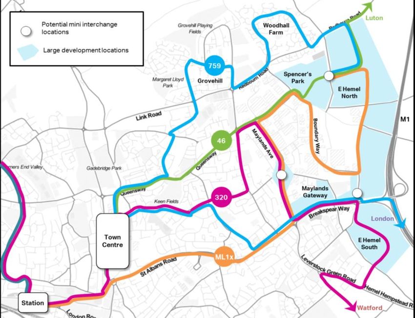
Location

     Maylands is located on the eastern side of Hemel                  Maylands in the local context
     Hempstead. The area is approximately 3km from Hemel
     Hempstead town centre and 4.5km from the town’s
     main railway station. St Albans is located around 6km
     to the east.                                            Maylands and the eastern Hemel Hempstead area
                                                             is located at the crossroads of the M1 (north-
                                                             south) and A414 (east west) strategic corridors.
             Maylands in the strategic context               M1 Junction 8 is located on the south-eastern
                                                                                               side of Maylands and
                                                                                               acts as the main east-
                                                                                               ern transport gateway
                                                                                               to Hemel Hempstead.
                                                                                               It is through M1 Junc-
                                                                                               tion 8 that the A414
                                                                                               crosses the M1, link-
                                                                                               ing Hemel Hemp-
                                                                                               stead with the rest of
                                                                                               Hertfordshire. The
                                                                                               M25 is located
                                                                                               around 6km to the
                                                                                               south of Maylands
                                                                                               and Luton Airport is
                                                                                               located 13km to the
                                                                                               north.

43
                                                                         Maylands Growth Corridor Study — Investment Prospectus
Why investment in infrastructure
in Maylands is needed

New homes and new jobs

                                          The Maylands and eastern Hemel Hempstead area will be a focus of new homes
                                          and jobs in the coming years. Over 4,000 new homes are planned in the immediate
                                          area, including the East Hemel Hempstead urban extension and Spencer’s Park. As
                                          part of the EnviroTech Enterprise Zone, around 8,000 new jobs are planned with
                                          renewal and intensification of the existing business park area and brand new office
                                          and logistics space provided within the Eastern Hemel Hempstead urban extension.

                                                                     Key Developments in the local area

                                                                                                                                5
Maylands Growth Corridor Study — Investment Prospectus
Transport Challenges
      Maylands attracts people in for work not just from Hemel Hemp-
      stead but from a wide area spanning towns such as Luton, Leigh-
      ton Buzzard and North Watford. Longer distance commuting
      journeys are more likely to be made by car than by public
      transport given the edge of town location of the business set
      away from Hemel Hempstead town centre and railway station.
      Roads like the M1 and A414 are key commuter corridors.

                                                      For commuting jour-
                                                      neys into Maylands
                                                      from within Hemel
                                                      Hempstead, a higher
                                                      proportion are from areas which immediately surround the busi-
                                                      ness park including Grovehill, Woodhall Farm and Adeyfield. There
    Al

                                                      are also commuting journeys from Bennetts End and Apsley on the
      lm
      od

                                                      southern edge of the town.
       es
           of
           tra
               vel

      For commuting journeys into Maylands from everywhere
      (including from other towns), nearly 80% of these trips are
      made by private car. This is over 11,000 trips to work. Howev-
      er, only 6% of people walk (around 900 trips) and 3% travel by
                                                                                          79%
      bus ( around 400 trips). Fewer travel by bike or by rail. There is
      untapped potential to increase non-car mode share, particular
      on foot and by bike for shorter distance journeys within Hemel Hempstead, but also by bus/coach from sur-
      rounding towns such as Luton and Watford.

      With so much reliance placed upon the private car to get to and from work in Maylands, this inevitably places
      highway links under strain within and surrounding the area. Severe traffic congestion is a regular occurrence
      during morning and evening peak periods on the A414 Breakspear Way (which is a main arterial route serving
      the entire town) especially so eastbound (towards the M1) and also on roads within Maylands including Bound-
      ary Way, Green Lane and Maylands Avenue. Observations indicate that it can take up to 10 minutes to travel
      just under 1km approaching the A414 Breakspear Way-Green Lane roundabout, with average speeds of less
      than 15mph (on a road with a speed limit of 70mph).

      Planned growth will generate additional demand on the transport network. If the current level of car mode
      share to work was maintained in the future, this could mean an extra 6,000 car movements to/from work every-
      day, many occurring during the morning and evening peak periods. Additional homes will also create additional
      travel demand , and whilst it is anticipated that some of the residents of the planned new housing develop-
      ments will work in Maylands and would therefore be less reliant on the car for commuting journeys, there will be
      people who need to travel elsewhere for work and other trip purposes. The planned additional homes in May-
      lands alone could generate an extra 5,500 cars, and a notable proportion of these could be using the road net-
      work during the peak periods.

      It is not just commuters who are affected. Many of the businesses in Maylands rely on the highway network to
      transport goods and services.—they need a quick and reliable transport network. Traffic congestion and de-
      lays can be damaging to the local economy.

6                                                                                  Maylands Growth Corridor Study — Investment Prospectus
Current problems
                                                                     A number of problems have been identified
                                              4                      through evidence gathering and discussions
                                                                     with stakeholders. The most prevalent issues are
         2
                                                                     shown in the figure to the left.
                    4
                                                                     1 - A dominant right turning movements from
                                             3
                                                                     the M1 towards Maylands (Green Lane north)
                                        5                            causes very long queues and delays on all other
                                                                     approaches.

                                                                     2 - Severance caused by very busy, heavily
                                                          5          trafficked roads makes crossing the road for
                                                                     pedestrians and cyclists quite difficult and po-
                                                                     tentially unsafe.

                                                                     3 - Traffic is rat-running on narrow lanes through
                                                                     the area to avoid queues elsewhere, including
                                                                     Cherry Tree Lane, Buncefield Lane and part of
                                              3
                                                                     Green Lane (south) through Leverstock Green
                                                              1
                                                                     4 - Access to the Nickey Line for pedestrians
                                                                     and cyclists is difficult especially from Chery
                                         2                3          Tree Lane and Three Cherry Trees Lane (very
                                                                     steep)

                                                                     5 - Obstructive HGV parking can cause damage
                                                                     to the highway verge, create litter and cause dis-
                                                                     ruption to traffic. on other roads
          Locations of problems

What might be the cause of these problems?
These problems may be caused by a number of underlying issues. The Maylands and eastern Hemel Hempstead
area is remote from Hemel Hempstead town centre and rail station making it too far to walk or cycle for many peo-
ple. The area’s close proximity to the M1 is an asset (making it attractive to business) but this also encourages the
use of the car. There is an unclear hierarchy of roads which is leading to less suitable, narrow lanes being used by
traffic when they could be reserved for pedestrians and cyclists. There is a lack of HGV parking both on and off road
for deliveries, leading to inconsiderate HGV parking in some locations. The type of employment provided in May-
lands is not always conducive to travelling by public transport or on foot/by bike because people are travelling at

How can these problems be tackled?
There are different approaches that can be used to tackle these problems. Planned development presents oppor-
tunities to deliver positive change to the Maylands area by providing much needed new and improved transport
infrastructure and services. Improvements will tackle these issues and deliver the following key outcomes

                                                                                                                          7
 Maylands Growth Corridor Study — Investment Prospectus
Stakeholders and Policy

     The Maylands Growth Corridor Study has been led by Hertfordshire Local Enterprise Partnership in collabora-
     tion with Dacorum Borough Council and St Albans City and District Council (the two local planning authorities),
     Hertfordshire County Council, Highways England and The Crown Estate (major landowner and promotor of the
     East Hemel Hempstead urban extension development).

     Since the Maylands Growth Corridor Study was commissioned, the EnviroTech Enterprise Zone Board has
     been set up to oversee the creation of the Enteprise Zone including the delivery of key transport improve-
     ments.

     The stakeholder group has helped to shape and direct the development of different aspects of the study, in-
     cluding the formation of supporting evidence and the generation of interventions (or Scheme Concepts as
     they are referred to in the study).

    Local businesses have been engaged at points during the development of the study to gather views on their
    priorities and preferences for infrastructure investment. All of these stakeholders will play a critical role in the
    realisation of the Maylands Growth Corridor Study proposals going forward.

                                                                                   Maylands Growth Corridor Study — Investment Prospectus
8
The transformation of Maylands is enshrined in policy and is supported by other strategies at a local and
more strategic level.

Supporting policy and strategy framework

 In a broader growth context, Hertfordshire’s Local Enterprise Partnership’s Strategic Economic Plan ’Perfectly
 Placed for Business’ 2017-2030, sets out the LEP’s priorities and aims for facilitating economic growth and main-
 taining prosperity across Hertfordshire. It provides the strategic background for growth in Maylands and under-
 pins the Enviro-Tech Enterprise Zone which was established in 2016.

 In a local planning context, the two local planning authorities—Dacorum Borough Council and St Albans City and
 District Council—have Local Plans (either adopted or emerging) which set out the level and spatial distribution of
 housing and economic growth across the area. Maylands and the East Hemel Hempstead area spans both plan-
 ning authorities therefore it is important to take on board both authorities’ future visions and proposals for hous-
 ing and economic growth as well as the need to maintain services and protect the environment. In addition to the
 local development plans, Dacorum Borough Council has an adopted masterplan and a series of planning briefs to
 guide the transformation of the Maylands business park.

 In a transport context, Hertfordshire County Council’s Local Transport Plan provides county-wide policy, objec-
 tives and proposals for the transport network. The emerging South West Hertfordshire Growth and Transport
 Plan translates LTP policies and goals at a sub-county level, and identifies packages of interventions within Hemel
 Hempstead and along inter-urban corridors such as the M1 and A414.

 In a broader context, Highways England has an ambitious programme to improve the Strategic Road Network,
 including the M1. The London to Scotland East Route Strategy (part of their Road Investment Strategy 2) identi-
 fies M1 Junction 8 as a key congestion point.

Maylands Growth Corridor Study — Investment Prospectus
                                                                                                                        9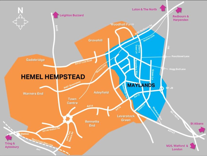
Developing the Study

     Work commenced in 2015 on the Maylands Growth Corridor Study.
     The study has been developed through a series of stages. Stage 0
     involved preparatory work to confirm the locations and severity of
     existing problems on the transport network and to clarify the levels of
     housing and employment growth coming forward. Stage 1 involved
     building the supporting evidence base and tools that would be used
     to inform the development of the study, including updates to the
     Hemel Hempstead Traffic Model. Stage 2 took the findings from
     Stages 0 and 1 and developed a series of Scheme Concepts that
     would address the transport problems and respond to future growth.
     The study has culminated in Stage 3 which has involved a process of
     appraisal, sifting of options and consideration of the phasing and
                                                                                           Study stages
     packaging of interventions.

     The study is presented in full across a series of core documents aligned with the study stages. These are summa-
     rised below. In addition, there is a range of supporting documents which align with the study’s findings and pro-
     posals, and these including the Local Transport Plan 4, South West Hertfordshire Growth and Transport Plan,
     Hemel Hempstead Evidence Pack, the local planning authorities’ Local Plans and the LEP’s Strategic Economic

       Maylands
       Growth Corridor
       Study core doc-
       uments

     A full list of core and
     supporting docu-
     ments are provided
     on page 32.

10
                                                                                  Maylands Growth Corridor Study — Investment Prospectus
Proposals
A series of interventions, known as Scheme Concepts,
have been devised to help facilitate important economic
growth in the Maylands and East Hemel Hempstead area
and to address existing and future challenges on the sur-
Interventions to improve walk- rounding transport network.
ing and cycling access and con-
The Scheme Concepts are wide ranging and designed to
nectivity cater for different users of the transport network in the
area.
Some of the interventions will provide additional highway
capacity, improved connectivity and enable more efficient
use and management of the road network in and around
Maylands. These interventions should reduce journey
times and traffic queues, and take traffic off narrower and
Interventions to improve route- less suitable parts of the highway.
ing and parking for large goods Some of the interventions recognise the importance of
vehicles providing safe, attractive and prioritised routes for pedes-
trians and cyclists, especially where these users are likely
to interact with and potentially come into conflict for mo-
torised vehicles. These interventions will open up May-
lands to its immediate surroundings and make journeys
on foot and bike to and through the area a more viable,
healthier and enjoyable mode of choice.
Interventions to introduce new Given Maylands’ edge of town location, some distance
from large parts of Hemel Hempstead including the town
and altered bus services and
centre and railway station, and in recognition that many
supporting infrastructure
employees live in other neighbouring towns, bus services
will continue to provide important short and medium dis-
tance connections. Enhancements to existing services as
well as new services and supporting infrastructure will
make bus and coach a far more attractive proposition.
Finally, the efficient movement of goods is vital to May-
Interventions to reduce con- lands, therefore recognition is given to a package of inter-
gestion and improve journey ventions which help local businesses transport goods
around more efficiently.
times
The full schedule of Scheme Concepts is shown over the
page along with a map identifying their broad locations.
Maylands Growth Corridor Study — Investment Prospectus
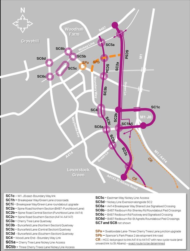
11The Maylands Scheme Concepts
Overview map of Scheme Concepts
Maylands Growth Corridor Study — Investment Prospectus
12Schedule of Interventions
Scheme
Concept Name ID Description
c M1 J8 east – Boundary Way link road
A414 Breakspear Way/Green Lane staggered signalised
h
SC1 Eastern Gateway crossroads including pedestrian/cycle bridge
A414 Breakspear Way/Green Lane roundabout signalisa-
i
tion upgrade
a Northern Section (B487-Punchbowl Lane)
Multi-Modal
SC2 b Central Section (Punchbowl Lane-A414)
Spine Road
c Southern Section (A414-A4147)
a Cherry Tree Lane Quietway
Quietway Green b Buncefield Lane (Northern Section) Quietway
SC3
Corridor c Buncefield Lane (Central Section) Quietway
d Buncefield Lane (Southern Section) Quietway
Wood End Lane-
SC4 Boundary Way - Wood Lane End - Boundary Way Link
Link Road
a Cherry Tree Lane Nickey Line Access
Nickey Line En- b Three Cherry Trees Lane Nickey Line Access
SC5
hancements c Eastman Way Nickey Line Access
d Nickey Line ‘branchline’ extension alongside SC2
a A414 Breakspear Way Shared Use Signalised Crossing
b B487 Redbourn Rd-Shenley Rd Roundabout Ped Crossings
Foot and Cycle
SC6 c B487 Redbourn Rd Footway and Signalised Crossing
Access Routes
d B487 Redbourn Rd-St Agnells Roundabout Ped Crossings
e A4147 Redbourn Rd crossing (Nickey Line)
a1 Further investigations re. expansion of Furnell's facility
a2 Expand Watling Street lorry park
a3 Introduce new lorry parking facility
b Subsidy of local HGV parking
c1 Better signage of Furnell’s Lorry Park and A5 Lorry Park
Lorry Parking c2 Promotional campaign to raise awareness of lorry parks
SC7
and Routing d1 Introduce Bollards
d2 Traffic Regulation Orders
d3 Awareness Campaign
e1 Formalise HGV laybys on Green Lane
e2 Introduce lay-bys on Eaton Road
f Revise delivery arrangements
Amended ML1 + Extension (2-way working on Maylands
a4
Avenue)
Bus Service En-
SC8 c Re-route Centrebus ‘46’
hancements
e Re-route Arriva ‘320’
f Extension of Greenline 759 commuter coach
Maylands Growth Corridor Study — Investment Prospectus
13Scheme Concept 1 (SC1)
Eastern Gateway
Improvements to M1 Junction 8 and A414
Breakspear Way-Green Lane Junction
One of the most significant and immediate challenges facing the Maylands and East Hemel Hempstead area is
severe congestion and delays on the A414 Breakspear Way and in the vicinity of M1 Junction 8. This is not only
critical to the immediate local area — the A414 is a major distributor route running through the middle of Hemel
Hempstead and it is also a major east-west arterial route crossing Hertfordshire and therefore provides a vital
inter-urban route between towns.
The A414 and M1 Junction 8 is the main gateway to Hemel Hempstead for people accessing jobs and ser-
vices. The A414 carries a mixture of local shorter distance and more strategic longer distance journeys by pri-
vate car, coach and HGV freight traffic.
What is the aim?
The aim of Scheme Concept 1 is to reduce current and future delays on the A414 Breakspear Way and adjoin-
ing routes in the vicinity of M1 Junction 8, and to provide additional capacity to enable planned new develop-
ments in Maylands and primarily the East Hemel Hempstead urban extension to go ahead.
What is proposed?
A range of highway-focused options have been considered, each varying in terms of scale and impact. It is im-
portant not to view each Scheme Concept in isolation, and that as a package the interventions will complement
each other. Whilst Scheme Concept 1 will deliver increased highway capacity which will reduce queues and
delays to motorists, it will also take pressure off other parts of the transport network so that they can facilitate
movements by bike or on foot and free up capacity for buses.
A phased approach has been devised. As shown below.
OPTIONAL FIRST STEP
Indicative phasing of SC1 options
Maylands Growth Corridor Study — Investment Prospectus
14SC1i A414 Breakspear Way-Green Lane roundabout signalisation
SC1i comprises of the implementation of full-time traffic signals on the A414-Green Lane roundabout and re-
shaping the central island and some approach arms to provide additional capacity for traffic.
SC1i is a potential interim measure which can deliver a moderate reduction in existing queue levels but is unlikely
to be sufficient to accommodate additional traffic generated by planned new development in the longer term.
The advantage of SC1i is that it will be quick to deliver and could have quite immediate beneficial effects on
transport users, albeit only for a short period.
SC1h Staggered signalised crossroads
SC1h could be delivered in the short-term in place of
SC1i (there would be no point in delivering them both
within a short timeframe which would be disruptive
and wasteful of limited funds) or it can follow SC1i af-
ter several years.
SC1h is integral to the emerging East Hemel Hemp-
stead development masterplan. It comprises of re-
placement of the existing A414-Green Lane rounda-
bout with a staggered signalised crossroads. This will
provide greater management and control to different
traffic movements. In the future, the junction will be an
important conduit not only for east-west traffic along
the A414 and to/from the M1, but also for north-
south movements between different parts of the East
Hemel Hempstead development. The existing Indicative Illustration of SC1c
roundabout layout will not be fit for purpose for deal-
ing with this change in pattern of movements in the longer term.
An important component of SC1h is a new high quality pedestrian and cyclist only bridge over the A414. This
bridge will link the East Hemel Hempstead North and South urban extensions together and form part of the cy-
cleway ‘branch’ off the Nickey Line to the north which will connect to a new off-road cycleway alongside the
A4147 to St Albans planned by Hertfordshire County Council. The bridge will be very user-friendly for pedestri-
ans and cyclists, with clear,
well lit and attractive
routes connected to the
development on either side
of the A414.
Cycle route via
SC1h bridge
Maylands Growth Corridor Study — Investment Prospectus
15SC1c M1 J8-Boundary
Way Link Road
Longer term, it is recognised that if May-
lands is to continue to thrive, a larger piece
of infrastructure will be needed which can
also help ensure traffic can exit and enter
the M1 motorway efficiently and safely.
SC1c is integral to planned new develop-
ment and the growth and continued pros-
perity of Maylands and Hemel Hempstead
as a whole. It comprises of a new rounda-
bout on the eastern side of the M1, con-
nected to the slip roads serving the south-
bound M1 carriageway and A414 towards
St Albans/Park Street. A new road will link the Indicative Illustration of SC1c
roundabout around the east of the M1 and over the
motorway, connecting into an enlarged and improved
Boundary Way-Green Lane roundabout. Traffic heading towards the A414 (Park Street) and M1 South (including
M25) from Maylands/East Hemel Hempstead, or coming from the north on the M1 towards Maylands/East Hem-
el Hempstead, will no longer need to use the A414 Breakspear Way. Traffic from the south on the M1 will still use
the A414 Breakspear Way
When will it happen?
SC1i could come forward within 2 years. Its delivery will be strongly tied to the Maylands Gateway development.
SC1h could come forward within 2-5 years during the early phases of East Hemel Hempstead urban extension
development, depending on when or if SC1i is implemented.
SC1c is a more complex intervention which could be delivered within 5-10 years, before the completion of East
Hemel Hempstead urban extension development.
Who will be responsible for delivering it?
SC1i can be delivered within the existing highway boundary and will be funded by local developers and delivered
by Hertfordshire County Council.
SC1h will require land outside of the existing highway boundary but within the control of The Crown Estate and
will be funded entirely by local developers including The Crown Estate. It will be delivered by Hertfordshire Coun-
ty Council or by the developer themselves.
SC1c will require land outside of the existing highway boundary but within the control of The Crown Estate and
will require funding from a mixture of sources including local developers and central Government. It will be deliv-
ered by Hertfordshire County Council. Or the developer themselves. As it will interact with the strategic road net-
work, Highways England will need to be heavily involved in the development and delivery of SC1c.
How much will it cost?
SC1i - < £250k
SC1h - £2m - £5m (depending on whether dualling of Green Lane is included or not)
SC1c - £15m - £25m (depending on composition of scheme)
Maylands Growth Corridor Study — Investment Prospectus
16Scheme Concept 2 (SC2)
Multi-Modal Spine Road
A new road linking together the Eastern
Hemel Hempstead development
The East Hemel Hempstead urban extension along with other key developments including Maylands Gateway and
Spencer’s Park, will change the volume and patterns of journeys across Maylands and the wider area. Future resi-
dents, employees and businesses will need access to the wider transport network.
New road links will be required to connect new development to the wider area.
What is the aim?
The aim will be to provide a highway connection be-
tween the B487 Redbourn Road in the north and the
A4147 St Albans/Hemel Hempstead Road in the south
via the A414 Breakspear Way. The link will utilise and
upgrade part of the existing Green Lane, and will enable
future residents and employees to access different
parts of the development. The link is necessary to en-
sure that the existing road network does not come un-
der increasing pressure in the future.
What is proposed?
For the purposes of the Maylands Growth Corridor
Study, the road link is divided into three parts.
SC2a – the northern stretch linking the B487 Redbourn
Road and Punchbowl Lane – 30mph single carriageway
road with potential for 20mph zones. Where it dissects
the Nickey Line, a new traffic signal controlled pedestri-
an/cyclist crossing will be provided.
SC2b – the central stretch linking Punchbowl Lane and
A414 Breakspear Way – 30mph mix of single and dual
carriageway road. Existing junctions with Three Cherry
Trees Lane and Boundary Way will be upgraded. It will tie
in with SC1h (the staggered crossroads).
SC2c – the southern stretch linking the A414 Break-
spear Way and A4147 St Albans Road – 30mph single
carriageway road with the potential for 20mph zones.
The existing Green Lane (from Leverstock Green) will be
diverted to meet the new link road. Where SC2c crosses
Westwick Row (part of the SC3 Quietway Green Corri-
dor) a pedestrian/cyclist crossing will be provided.
SC2 connectivity Importantly, SC2 is not envisaged to act as a high ca-
pacity bypass for Hemel Hempstead. It will be single car-
riageway and a 30mph speed limit (with potential for 20mph zones) will be in place over much of its length. The re-
quired access and connectivity for planned new development needs to be balanced with opportunities to provide
an alternative route for traffic within the wider Hemel Hempstead area.
Maylands Growth Corridor Study — Investment Prospectus
17Spine road cross-
section
Indicative alignment of SC2
When will it happen?
Scheme Concept 2 will be phased in line with planned development at Spencer’s Park Phase 2 and East Hemel
Hempstead. The northern stretch will be strongly associated with Spencer’s Park Phase 2 and East Hemel
Hempstead North (residential), as will the central section. The central section will be phased in line with devel-
opment of the commercial element of the East Hemel Hempstead development and also the northern part of
the development. The southern stretch will be strongly associated with East Hemel Hempstead South
(residential and employment).
Who will be responsible for delivering it?
The developer of East Hemel Hempstead will be exclusively responsible for delivering Scheme Concept 2 as an
integral element of the planned development, albeit the road could have wider benefits. Once completed, the
new road will eventually be adopted by Hertfordshire County Council formally as part of the wider highway net-
work.
How much will it cost?
The cost of SC2 is to be determined. It is expected to be funded entirely by the East Hemel Hempstead devel-
oper.
Maylands Growth Corridor Study — Investment Prospectus
18Scheme Concept 3 (SC3)
Quietway Green Corridor
A new north-south quiet route primarily for
pedestrians and cyclists
What is the aim?
The Maylands area is currently criss-crossed by a series of attractive narrow lanes which are quite rural in char-
acter despite running through or close to industrial uses. Running from the B487 Redbourn Road to the A4147
St Albans Road, via the A414 Breakspear Way, Cherry Tree Lane, Buncefield Lane and Westwick Row com-
bined form a green artery through the Maylands area.
Some sections however also serve as rat-runs for motorists trying to avoid traffic congestion on other routes,
for example Cherry Tree Lane acts as a northern gateway to the Maylands area and an alternative route to-
wards M1 Junction 8 for traffic from places like Redbourn and parts of northern Hemel Hempstead and be-
yond. Cherry Tree Lane is undulated and quite narrow in parts so it is not possible for two vehicles to pass each
other easily.
Similarly, the section of Buncefield
Lane between Wood Lane End and
the A414 can often be used by traffic
heading out of the Maylands area,
wishing to avoid long queues on the
A414 heading towards the M1.
As Maylands and the eastern Hemel
Hempstead area evolves and devel-
ops, there is real opportunity to safe-
guard these attractive green lanes,
with pedestrians, cyclists and other
non-motorised users given more pri-
ority over traffic. Three Cherry Tree
Lane, Buncefield Lane and Westwick View southwards along Buncefield Lane
Row combined will provide a continuous link near to Wood Lane End
for leisure and commuter trips on foot and by bike
into and out of Maylands and for residents and employees in the area to enjoy.
View southwards along
Cherry Tree Lane
Maylands Growth Corridor Study — Investment Prospectus
19What is proposed?
The proposal is to convert the existing lanes into
Quietways. A mix of new signs and kerbed build-
outs will the implemented to discourage through
movements along with areas where vehicles will
be banned.
Scheme Concept 3 comprises of interlocking
components:
SC3a - Cherry Tree Lane (from B487
Redbourn Road to the junction with Three Cher-
ry Trees Lane)
SC3b – Buncefield Lane northern section
(from Three Cherry Trees Lane to Boundary
Way)
SC3c – Buncefield Lane central section (from
Boundary Way to A414 Breakspear Way)
SC3d – Buncefield Lane southern section
(from A414 Breakspear Way to Green Lane) +
Westwick Row (from Green Lane to A4147 St
Albans Road)
Restrictions will be made more effective by the
provision of new alternative highway links which
are designed to cater for traffic unlike these
lanes. These alternative routes include Scheme
Concept 2 (the eastern development spine
road) and Scheme Concept 4.
New and improved crossing facilities will be re-
quired where the Quietway corridor intersects
with heavily trafficked routes such as the A414.
Apart from new signage at entrances, the lanes
themselves will not alter in character – there will
be no need for widening of the roads, installation of Scheme Concept 3 indicative
footways or additional street furniture for exam- alignment
ple.
When will it happen?
All of these components will be simple to deliver, Who will be responsible for delivering it?
however they cannot be implemented until the al-
ternative road links are in place otherwise there is a Hertfordshire County Council will bring forward Scheme Con-
risk that traffic will continue to use the lanes which cept 3.
means that pedestrians and cyclists will not feel
How much will it cost?
safe using them.
The cost of all components could be in the region of £225k
and £275k, subject to more detailed feasibility investigations.
Maylands Growth Corridor Study — Investment Prospectus
20Scheme Concept 4 (SC4)
Wood Lane End-Boundary Way
Link Road
A new link road to facilitate access to Maylands
Gateway
What is the aim?
Traffic congestion is occurring on
routes within Maylands and in particu-
lar Boundary Way, Maylands Avenue
and key access points along the A414
and B487 corridors. The section of
Wood Lane End running east from
Maylands Avenue to Buncefield Lane,
and the section of Buncefield Lane
running down to the A414 can be used
as a rat-run for traffic in weekday
morning and evening peak periods,
especially as a way of avoiding queues View northwards along Buncefield Lane
and delays on the A414 heading to- towards Boundary Way
wards the M1. Wood Lane End is a two
-way road with residential and com-
mercial land uses at the western end SC4 and surrounding roads
near to Maylands Avenue, and pre-
dominantly residential at the eastern
end. Proposed commercial develop-
ment at Maylands Gateway will change
traffic volumes and routeings on Wood
Lane End.
The aim of the Wood Lane End-
Boundary Way link road is to help facili-
tate the proposed commercial devel-
opment at Maylands Gateway, and in
conjunction with SC3 (Quietways), re-
lieve Buncefield Lane of rat-running
traffic.
Maylands Growth Corridor Study — Investment Prospectus
21What is proposed?
A new two-way single carriageway link
road will be constructed from Boundary
Way to the existing highway on Buncefield
Lane.
The section of Buncefield Lane between
Wood Lane End and Boundary Way is cur-
rently used as a segregated cycleway/
footway. There is a wide bridleway be-
tween two fence lines along the eastern
side of the cycleway/footway. The cy-
cleway/footway and bridleway join the
southern side of an access road that has
been provided for Martin Brower UK
(Bryanston Court) which forms the south-
ern arm of a roundabout on Boundary
Way.
The new link road will be wide enough to
accommodate a cycleway/footway and
bridleway (part of SC3 Quietway corridor)
alongside the eastern side of the new two-
way road.
Measures will be put in place to discour-
age traffic entering the Maylands area via
the new link road, other than the proposed
Maylands Gateway development.
When will it happen?
Scheme Concept 4 will be delivered in line
with the proposed Maylands Gateway de-
velopment which could come forward in Scheme Concept 4indicative
the short term. This will then help unlock alignment
the central section of Scheme Concept 3
along Buncefield Lane, and Scheme Con-
cept 6d which comprises of a new pedestrian/cycle crossing on the A414 Breakspear Way.
Who will be responsible for delivering it?
The developer of the Maylands Gateway site will be responsible for delivering the new road link as it will pri-
marily serve as access to the development site. The road link will eventually be adopted by Hertfordshire
County Council as part of the local road network.
How much will it cost?
The road link has been initially estimated to cost between £750k and £1m, however this is subject to more
detailed design and feasibility investigations being undertaken by the developer for the proposed commer-
cial development at the central part of the Maylands Gateway in discussions with Hertfordshire County
Council.
Maylands Growth Corridor Study — Investment Prospectus
22Scheme Concept 5 (SC5)
Nickey Line Enhancements
Improved Accesses and ‘branchline’ extension
What is the aim?
Poor linkage between the Nickey Line (National Cycle Route 57), Cherry Tree Lane and Three Cherry Trees
Lane has been identified. The existing connections from these roads onto the Nickey Line are steep and un-
made – the existing facilities do not conform to preferred widths and gradients.
This is likely to deter pedestrians and cyclists from using the Nickey Line as either a leisure or commuting
route. With planned housing and employment development coming forward in the area, the Nickey Line has
the potential to become a vital, largely traffic-free, route east-west between Hemel Hempstead town centre
and Maylands. Furthermore, better north-south links connecting into the Nickey Line, such as the SC3 Qui-
etway, as well as a new ‘branch’ off the Nickey Line which feeds through the East Hemel Hempstead urban
extension will open up many new local journey opportunities.
What is proposed?
Improved access facilities are proposed from
Cherry Tree Lane (SC5a) and Three Cherry
Trees Lane (SC5b) where they route over and
under the Nickey Line respectively.
On Cherry Tree Lane, it is envisaged that a sys-
tem of ramps with appropriate gradients for cy-
clists and pedestrians to negotiate would be
provided between the level of the road and the
level of the track.
On Three Cherry Trees Lane, two options could
be considered for this location: 1 – A direct
route along the line of the current unmade con-
nection; or 2 – a route with a quarter turn so that
a longer path with appropriate ramp gradients
between the road and the Nickey Line can be
provided.
Access steps to the Nickey Line
from Cherry Tree Lane
Directional signage along the
Nickey Line
Maylands Growth Corridor Study — Investment Prospectus
23Eastman Way is a two-way road cul-de-sac,
which provides access to a light industrial
area. The Nickey Line is severed by Eastman
Way near the eastern end of the estate
road. There is a section of estate road be-
tween the western and eastern ends of the
Nickey Line. Pedestrians and cyclists are
directed along the northern footway be-
tween these junctions with the Nickey Line.
However, there is a vehicular entrance to a
household waste site near the western junc-
tion with the Nickey Line, two further direct
access points across the northern footway,
and no crossing point where pedestrians
and cyclists are required to cross the road
to join the eastern junction with the Nickey
Line.
There is an opportunity to widen the north-
ern footway on Eastman Way between the
western junction with the Nickey Line and
the junction with the northern arm of the cul
-de-sac (SC5c).
A new cycleway ‘branchline’ (SC5d) off the
Nickey Line will route alongside SC2a and b
as a segregated cycleway, with at-grade
crossings at all intermediate junctions
(including a potentially signalised crossing
on the new SC1c ‘loop’ link road) and a pe-
destrian/cycle bridge over the A414 between Scheme Concept 5 locations
Green Lane and the M1, and eventually connect
with a brand new cycleway which will run alongside the A4147 towards St Albans (with onward connection to Ver-
ulamium Park and the St Albans Green Ring). The bridge over the A414 will be delivered as part of SC1h.
When will it happen? SC5a and b (the improved Nickey Line access points) could happen in the short
-term but should be timed to coincide with the implementation of SC3a (Cherry Tree Lane quietway) SC5c
(Eastman Way improvements) is not linked to other interventions and can come forward in the short term.
Illustration of new access ramp linking SC5d (the cycleway ’branchline’) is strongly
Three Cherry Trees Lane and the Nickey tied to the phased construction of SC2a and
Line b. (the East Hemel Hempstead spine road).
Who will be responsible for
delivering it?
SC5a-c will be delivered by Hertfordshire
County Council in discussion with the Friends
of the Nickey Line, Sustrans and local authori-
ties.
SC5d will be delivered by the EHH developer
along with SC2 in discussion with Hertford-
shire County Council who will eventually adopt
it as part of the highway.
How much will it cost?
SC5 - approximately £220k-£335k (excluding
SC5d)
Maylands Growth Corridor Study — Investment Prospectus
24Scheme Concept 6 (SC6)
Foot & Cycle Access Routes
Improved footway/cycleway accesses and
crossings on routes into Maylands
What is the aim?
The Maylands business park attracts people from a large catchment area. There are however a notable pro-
portion of the area’s employees who live within Hemel Hempstead and within easy walking or cycling distance
of the area. It is recognised however that there are potential barriers which could be discouraging people from
walking to work.
Maylands is surrounded and dissected by heavily-trafficked roads which could be quite difficult to cross be-
cause existing facilities are not well linked to footways or cycleways or there are not enough of them serving
the journeys people need to make.
Several key roads are considered to cut-off Maylands from its surroundings. The B487 Redbourn Road sepa-
rates the Woodhall Farm and Grovehill residential areas from Maylands. It is estimated that around nearly 1,000
commuting journeys are made to Maylands from these areas but not all of these are on foot—some are by car.
The northern and southern arms of Buncefield Lane are severed by A414 Breakspear Way. Breakspear Way is
a two-lane dual carriageway subject to the national speed limit, which provides the main link east/west link be-
tween the M1 motorway and Hemel Hempstead Town Centre.
The aim of Scheme Concept 6 is to reduce severance caused by heavily trafficked roads and make walking
and cycling over short distances into, out of and through Maylands a more attractive travel mode of choice.
SC6 locations
A414—location of SC6a
Maylands Growth Corridor Study — Investment Prospectus
25What is proposed?
Scheme Concept 6 comprises of five component interventions:
SC6a involves a new shared use, pedestrian/cyclist signalised Toucan crossing on the A414 Breakspear Way in
proximity to the two petrol filling stations. SC6a will be critical to the delivery of the SC3 Quietway as well as im-
proving access on foot and by bike to Breakspear Park and the Holiday Inn hotel.
SC6b involves improving crossing facilities at the B487 Redbourn Road-Shenley Road roundabout. The rounda-
bout will remain, however crossing distances
will be reduced and footway pavement widths
will be enlarged. SC6b will be strongly linked
to the improved access to the Nickey Line
(SC5b).
SC6c involves providing a new signal-
controlled crossing on Redbourn Road near
the Shenley Road roundabout. The new
crossing would be located between the east-
bound and westbound bus stops, and a new
footway would be provided in the southern
verge between the crossing and the west-
bound bus stop.
SC6d involves improving crossing facilities at
the B487 Redbourn Road-St Agnells Lane-
Link Road roundabout.
SC6e involves the implementation of a new
signal-controlled crossing on the A4147
Redbourn Road. There is currently an uncon-
trolled crossing via a central refuge located SC6a indicative drawing
approximately 200m from the St Agnells Lane
roundabout, which provides continuity between the west-
ern and eastern sections of the Nickey Line. This section
of Redbourn Lane is subject to a 40mph speed limit with street lighting present.
A new signal-controlled crossing for cyclists as well as pedestrians would be provided to replace the uncontrolled
crossing. The central refuge island would be removed and footways on both sides of Redbourn Road will be wid-
ened and larger waiting areas will be provided to receive the new signal-controlled crossing, to improve condi-
tions for those cyclists and pedestrians attempting to cross.
When will it happen?
All SC6 component interventions can come forward in the short term. This is critical, as it will help improve access
to Maylands on foot and by bike for existing users.
Who will be responsible for delivering it?
Hertfordshire County Council as highway authority will be responsible for delivering all of the SC6 component in-
terventions.
How much will it cost?
SC6 components in combination could cost between £410k and £675k, subject to further more detailed feasibil-
ity investigations.
Maylands Growth Corridor Study — Investment Prospectus
26Scheme Concept 7 (SC7)
Lorry Parking and Routeing
Improved parking and routeing for heavy goods
vehicles visiting Maylands
Heavy Goods Vehicle traffic generated in Maylands require good access to the wider road network. The
main access route is via the A414 Breakspear Way and M1 Junction 8 which facilitates movements north-
south along the M1, towards the M25 (and to Watford, London and the South and South-West of England
beyond) and east along the A414 to the rest of Hertfordshire and the A1(M) corridor.
Despite the numerous highway connections into Maylands, many are not suitable to HGVs. The three main
access routes are Green Lane and Maylands Avenue (from the A414) and A4147 Redbourn Road and Swal-
lowdale Lane. Three Cherry Trees Lane has height and width restrictions in place to prevent and discourage
HGV movements, and Cherry Tree Lane has a weight limit in place. Other routes are either residential in na-
ture, such as the western end of Wood Lane End or narrow country lanes such as Hogg End Lane and
Punchbowl Lane which have weight restrictions in place.
Businesses in Maylands, including Amazon, Next, Martin Brower UK, Gist, Robert Dyas and many more are
reliant upon the highway network to transport goods across a wide area. Quick and reliable access to the
A414, M1 and A4147 is therefore essential.
Roads surrounding Maylands are susceptible to congestion especially during weekday morning and evening
peaks. This can be disruptive to businesses both in terms of employees having difficulties getting to/from
work, but also in the transport of goods and services. Many of the logistics firms in Maylands operate on
tightly managed schedules to maintain efficiency. If goods and services cannot arrive or depart on time due
to congestion on surrounding roads, this can have a detrimental effect on businesses and their prosperity.
HGV parking is also an issue. Intermittent parking by HGVs on constrained roads within Maylands can create
a lot of disruption. There is not enough space for HGVs to park up, albeit for a short time (for instance if they
are awaiting a specific delivery time slot) without causing difficulties for other vehicles trying to get around
the HGVs.
There is also a wider parking issue caused by HGV drivers using the M1 and taking advantage of some qui-
eter roads in Maylands for a longer stay during the daytime or overnight. HGVs can park on Three Cherry
Trees Lane and on Green Lane, and whilst this may not be hugely disruptive to traffic movements, vehicles
can cause a lot of damage to highway verges and there is also a problem with litter.
HGVs parked on Three Cherry Furnells Lorry Park, Maxted
Trees Lane Road
Maylands Growth Corridor Study — Investment Prospectus
27Lorry Parking Signage
What is proposed?
A package of interventions are recom-
mended, most of which will require more
detailed investigations and discussions
with stakeholders. To help address a lack
of off-road parking for HGVs, either expan-
sion of the existing Furnells lorry park or
the A5183 Watling Street lorry park, or
provision of a brand new lorry park could
be undertaken. All of these options will
require additional land and could be very
expensive. There is considered to be a
reluctance by HGV drivers to pay for park-
ing. Investigations into a potential subsidy
of local HGV parking could be investigated.
The cost of this will be dependent upon Current HGV access routes into Maylands
the level of uptake and subsidy. Better
signage of existing parking facilities such
as Furnells Lorry Park should be consid- Eaton Road is one location where a layby for short term HGV park-
ered as drivers may not be aware the facili- ing could be introduced. Further investigations will be required to
ty is available. This could be combined with determine if this is feasible and how it can be ensured that the layby
a promotional campaign to raise aware- is not used by cars. Further engagement with logistics companies
ness of all lorry parks, through engage- in the Maylands area to determine how they can optimise their op-
ment with local and national logistics com- erations in terms of HGV delivery arrangements should be under-
panies. To manage HGV parking in appro-
taken. Also, further work is required to determine the potential for a
priate places, bollards and other control-
new logistics park for the area, providing short and long term park-
ling measures can be introduced. Bollards
ing facilities with sufficient capacity and high quality facilities.
and earth bunding were introduced on
Green Lane in early 2017 in addition to
new Traffic Regulation Orders that will When will it happen?
make parking in specified locations an
Some of the interventions could be quite quick to deliver within 2-5
offence. It is also recommended that new
years. The creation of dedicated lorry parking facilities off the high-
laybys be considered.
How much will it cost?
The cost of measures is to be
determined, based on more de-
Eaton Road —potential tailed investigations and prioriti-
location for short term
sation of measures.
lorry parking
Maylands Growth Corridor Study — Investment Prospectus
28Scheme Concept 8 (SC8)
Bus Service Enhancements
New and improved bus service routes for local
and longer distance journeys
What is the aim?
Buses do not currently play a major role in transporting people into and out of
Maylands. There are services which skirt the edges of Maylands along the A414
Breakspear Way, B487 Redbourn Road and also along Maylands Avenue. There
is only one service which penetrates the eastern part of the Maylands employ-
ment area. Looking ahead, with an increased residential population to the east
of Maylands there will be opportunity to improve bus service connectivity to key
locations including Hemel Hempstead town centre, railway station and sur-
rounding urban centres including Watford and Luton. Bus and coach services
can therefore play a crucial role in providing an attractive alternative to the car,
especially if services are frequent and accessing them is convenient for both
new residential areas and Maylands business park.
What is proposed?
A series of bus service alterations are being considered, as shown below. This Centrebus 46 &
section sets out one potential strategy but other options could be considered. Arriva Greenline
Further dialogue with bus operators, Hertfordshire County Council and other 758/9
parties will be required to determine the potential for bus service improvements.
Potential bus route changes
29The emphasis will be on the enhancement of existing services as opposed to providing brand new services. This will
ensure that existing services can continue to serve local communities, but the usage of these services could be in-
creased as the service routes are extended and altered to connect with Maylands and new developments including
Spencer’s Park and East Hemel Hempstead urban extension.
Arriva Greenline 758/9 is a commuter coach service linking Hemel Hempstead and Central London. Peak time ser-
vices commence in the Woodhall Farm area. The service will instead start in the Spencer’s Park/East Hemel Hemp-
stead UA (North) area but will continue to serve Woodhall Farm. Centrebus 46 links Luton and Hemel Hempstead. It
does not currently serve the main part of Maylands. The proposal is to re-route this service to connect with new de-
velopments. Arriva 320 links Watford and Hemel Hempstead via Leverstock Green and Maylands Avenue. The ser-
vice can be re-routed via East Hemel
Hempstead South. Finally, the exist-
ing ML1 service can be extended to
serve most of East Hemel Hemp-
stead North development and Spen-
cer’s Park.
To complement these service
changes, supporting infrastructure
will be required such as attractive bus
stops (with seating, shelters and real
Example bus interchange time information panels indicating
when services are due to arrive). One
or a series of mini coach/bus inter-
Hemel Hempstead bus
changes will act as focal points for
interchange
more than one service, enabling peo-
ple to change buses. A larger eastern
Potential interurban bus connectivity gateway hub, located close to the
A414 corridor could provide shorter
and longer distance services. The
proposed East-West cross-county
bus rapid transit system (promoted in
LTP4) linking Hemel Hempstead and
Hatfield could also call at the eastern
hub, improving inter-urban connec-
tivity to Maylands.
When will it happen?
Service changes will be reliant upon
new road links being in place such as
SC2 and the build-out of planned
development.
Who will be responsible
for delivering it and how
much will it cost?
Further engagement with local bus
operators is required before service
changes are committed and more
detailed service specifications can
be drawn up.
Maylands Growth Corridor Study — Investment Prospectus
30The way ahead
The Maylands Scheme Concepts will be delivered over a number of years, governed by when and how much
funding is available, when key housing and employment developments come forward, on the adoption of Local
Plans and when more detailed design and feasibility investigations are complete.
The full schedule of interventions is provided on page 13.
First...
By 2020/21 / Within 2 years
Business case for SC1c completed
Planning Application submitted for East
Hemel Hempstead urban extension
SC7c4 SC7c2 SC5b-c
Maylands Gateway completed
SC7d3 SC7f SC6b-e
New Local Plans for Dacorum and St Albans
SC1i
Public realm improvements
First set of interventions delivered
Then... East Hemel Hempstead development gets underway
By 2023/24 / Within 5 years
Additional public realm
SC5d SC2a SC8a4 SC2b SC2c improvements
SC8c&f SC7e2 SC1h SC8e
SC4 Scope for further innovative
Next set of interventions measures for achieving modal
SC5a SC3a-d SC6a delivered shift identified in planning
documents
Finally...
By 2028/29 / Within 10 years East Hemel Hempstead development nearing completion
Further public realm im-
SC1c provements
Final intervention delivered
Maylands Growth Corridor Study — Investment Prospectus
31Next Steps
The Maylands Growth Corridor Study sets out the broad framework of proposals and supporting evidence to
deliver positive change and facilitate growth in the area as part of the EnviroTech Enterprise Zone.
However, more detailed work will need to be undertaken in order to bring forward the proposals set out in this
document. The Stage 3 Phasing and Packaging report provides more detail on the next steps for individual
Scheme Concepts. A set of generic steps is provided below. These steps should be commenced in 2018 and
Maylands Growth Corridor Study — Investment Prospectus
32You can also read