Macquarie Park Planning Proposal - Harvey Norman Group May 2013 - City of Ryde
←
→
Page content transcription
If your browser does not render page correctly, please read the page content below

Macquarie Park Planning
               Proposal
           Harvey Norman Group

                       May 2013
URBIS STAFF RESPONSIBLE FOR THIS REPORT WERE:

Director                               Stephen White
Senior Consultant                      Norelle Jones
Job Code                               SA4757
Report Number                          Final
xdisclaime rx

© Urbis Pty LtdAll Rights Reserved. No material may be reproduced without prior permission.
ABN 50 105 256 228

Disclaimer

This report is dated April 2013 and incorporates information and events up to that date only and excludes any information arising, or event occurring, after that date which
may affect the validity of Urbis Pty Ltd’s (Urbis) opinion in this report. Urbis prepared this report on the instructions, and for the benefit only, of Harvey Norman (Instructing
Party) for the purpose of Planning Proposal application (Purpose) and not for any other purpose or use. Urbis expressly disclaims any liability to the Instructing Party who
relies or purports to rely on this report for any purpose other than the Purpose and to any party other than the Instructing Party who relies or purports to rely on this report for
any purpose whatsoever (including the Purpose).

In preparing this report, Urbis was required to make judgements which may be affected by unforeseen future events including wars, civil unrest, economic disruption, fin ancial
market disruption, business cycles, industrial disputes, labour difficulties, political action and changes of government or law, the likelihood and effects of which are not
capable of precise assessment.

All surveys, forecasts, projections and recommendations contained in or made in relation to or associated with this report ar e made in good faith and on the basis of
information supplied to Urbis at the date of this report. Achievement of the projections and budgets set out in this report will depen d, among other things, on the actions of
others over which Urbis has no control.

Urbis has made all reasonable inquiries that it believes is necessary in preparing this report but it cannot be certain that all information material to the preparation of this
report has been provided to it as there may be information that is not publicly available at the time of its inquiry.

In preparing this report, Urbis may rely on or refer to documents in a language other than English which Urbis will procure the translation of into English. Urbis is not
responsible for the accuracy or completeness of such translations and to the extent that the inaccurate or incomplete translation of any document results in any statement or
opinion made in this report being inaccurate or incomplete, Urbis expressly disclaims any liability for that inaccuracy or incompleteness.

This report has been prepared with due care and diligence by Urbis and the statements and opinions given by Urbis in this report are given in good faith and in the belief on
reasonable grounds that such statements and opinions are correct and not misleading bearing in mind the necessary limitat ions noted in the previous paragraphs. Further,
no responsibility is accepted by Urbis or any of its officers or employees for any errors, including errors in data which is either supplied by the Instructing Party, supplied by a
third party to Urbis, or which Urbis is required to estimate, or omissions howsoever arising in the preparation of this report, provided that this will not absolve Urbis from
liability arising from an opinion expressed recklessly or in bad faith.

URBIS
Australia Asia Middle East
urbis.com.au

Executive Summary ............................................................................................................................ 1
    Overview....................................................................................................................................... 1
    Proposed Concept Masterplan ...................................................................................................... 1
    Proposed LEP Amendment ........................................................................................................... 2
    Planning Outcomes ....................................................................................................................... 3
    Assessment .................................................................................................................................. 3
    Conclusion .................................................................................................................................... 4

1      Introduction ................................................................................................................................. 5

2      Land to which the Planning Proposal applies ........................................................................... 7
       2.1   Site Description .................................................................................................................. 7
       2.2   Existing Development ......................................................................................................... 8
       2.3   Surrounding Context ........................................................................................................... 9
       2.4   Planning Context .............................................................................................................. 13

3      Planning Proposal Overview .................................................................................................... 15

4      Part 1 – Objectives or Intended Outcomes .............................................................................. 17
       4.1    Objectives......................................................................................................................... 17
       4.2    Intended Outcomes .......................................................................................................... 18

5      Part 2 – Explanation of the LEP Provisions ............................................................................. 29
       5.1    Overview .......................................................................................................................... 29
       5.2    LEP Amendments ............................................................................................................. 29
       5.3    Proposed land use zoning................................................................................................. 30
       5.4    Height & FSR Controls...................................................................................................... 31
       5.4.1 Relationship to Existing Local Planning Instrument............................................................ 32

6      Part 3 – Justification for the Planning Proposal ...................................................................... 33
       6.1.1 Section A – Need for the Planning Proposal ...................................................................... 33
       6.1.2 Section B – Relationship to strategic planning framework .................................................. 35
       6.1.3 Section C – Environmental, social and economic impact ................................................... 45
       6.1.4 Section D – State and Commonwealth interests ................................................................ 47

7      Part 4 - Community Consultation ............................................................................................. 49

8      Conclusion ................................................................................................................................ 51

Appendix A               Concept Masterplan and Urban Design Report .................................................... 53

Appendix B               Traffic Report ......................................................................................................... 55

Appendix C               Civil and Structural Report .................................................................................... 57

Appendix D               Proposed LEP Map................................................................................................. 59

Appendix E               Proposed Voluntary Planning Agreement Offer ................................................... 61

URBIS
SA4757_PLANNING PROPOSAL_MAY 2013                                                                                                      TABLE OF CONTENTS   I
FIGURES:
        Figure 1 – Site Description .......................................................................................................................... 7
        Figure 2 – Site Plan..................................................................................................................................... 8
        Figure 3 – Medium and High Density Residential Development within Macquarie Park ................................ 11
        Figure 4 – Eastern and Western Extent of Macquarie Park Corridor Defined by Mixed Use Development..... 11
        Figure 5 – North Ryde Station Precinct Site (Extract from State Significant Study) ....................................... 12
        Figure 6 – Existing Land Use Zone ............................................................................................................ 13
        Figure 7 – Relevant Development Controls ................................................................................................ 14
        Figure 8 – Indicative Building Envelopes .................................................................................................... 19
        Figure 9 – Concept Masterplan .................................................................................................................. 20
        Figure 10 – Proposed Open Space ............................................................................................................ 21
        Figure 11 – Proposed Internal Street Network ............................................................................................ 22
        Figure 12 – Preferred Alternative Concept - Site Boundary ......................................................................... 24
        Figure 13 – Preferred Alternative Concept.................................................................................................. 26
        Figure 14 – Proposed Land Use Zoning ..................................................................................................... 30
        Figure 15 – Subject Site comprises a Residual Parcel of Land Adjacent to the North Ryde Station Urban
                     Activation Precinct .................................................................................................................. 33
        Figure 16 – Emerging Mixed Use Precincts within Macquarie Park ............................................................. 34
        Figure 17 – Macquarie Park Specialised Centre ......................................................................................... 36
        Figure 18 – Global Economic Corridor ....................................................................................................... 37

TABLES:
        Table 1 – Site Description............................................................................................................................ 7
        Table 2 – Local Development .................................................................................................................... 10
        Table 3 – Summary of Proposed Development........................................................................................... 18
        Table 4 – Comparison of Proposed Development under Concept Masterplan and Preferred Alternative Concept
                    .............................................................................................................................................. 25
        Table 5 – Contribution of the Planning Proposal to the Strategic Objectives of the Metro Plan ..................... 39

II   TABLE OF CONTENTS
                                                                                                                                                             URBIS
                                                                                                                                  SA4757_PLANNING PROPOSAL_MAY 2013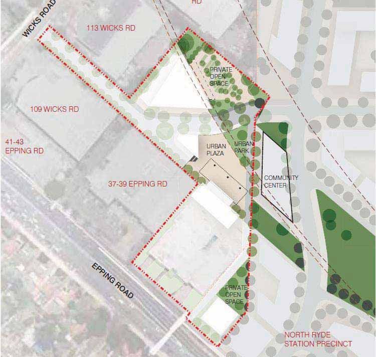
This page is intentionally blank

URBIS
SA4757_PLANNING PROPOSAL_MAY 2013

This page is intentionally blank

                                                              URBIS
                                   SA4757_PLANNING PROPOSAL_MAY 2013
Executive Summary
OVERVIEW
This Planning Proposal has been submitted on behalf of the Harvey Norman Group. The Planning
Proposal is for an amendment to the local environmental planning controls for land at 111 Wicks Road
(Lot 10 in DP1046090), 29 Epping Road (Lot 2 in DP52488) and 31-35 Epping Road (Lot 1 in
DP1151499), Macquarie Park (“the site”). The site equates to approximately 1.97 hectares and is
strategically located in the south-eastern edge of Macquarie Park, close to the North Ryde rail station.
The purpose of the Planning Proposal is:
To revitalise this significant landholding enabling the development of a mixed use scheme that
integrates commercial office, retail, hotel and residential uses on the site.
To provide a detailed Concept Masterplan that delivers a new public road and urban square, capable
of being translated into Development Control Plan (DCP) controls and complementary to the
proposed development on the adjacent North Ryde Station Urban Activation Precinct (NRSUAP).
Enable the development of commercial floor space of a scale that will support occupation by:
Proposed headquarters of international company Harvey Norman.
A new hotel operator.
PROPOSED CONCEPT MASTERPLAN
To assist in conceptualising the character of the envisaged development, a Concept Masterplan that
would ultimately form the basis of a future staged development application has been prepared by
architects Allen Jack + Cottier.
The key features of the Concept Masterplan include:
New public road: Extending east-west through the site connecting to Wicks Road (North) and the
NRSUAP to the east.
New open space: A new urban square and associated landscaped spaces will be developed to help
activate the ground level of the development. Pedestrian and cycle links seamlessly connecting to the
NRSUAP will be provided.
Commercial offices for proposed headquarters of international company Harvey Norman: An 8 storey
addition at the rear of the existing Domayne / Harvey Norman store (existing 3 storey building)
providing office space for the Harvey Norman group.
Commercial offices: A new 6 storey commercial building with main road frontage to Epping Road.
Neighbourhood Shops: Neighbourhood facilities including shops and cafes (and potentially a child
care centre) at ground level to meet the local convenience needs of existing and future residents and
activate the new urban square.
Hotel: 200 hotel suites owned and managed by an operator accommodated within the lower 10 levels
of a new building at 111 Wicks Road.
Residential Apartments: Approximately 160-170 apartments accommodated within the upper 17
levels of a new building at 111 Wicks Road.
Domayne / Harvey Norman Store: The existing Domayne / Harvey Norman store will remain in its
current location.
URBIS
SA4757_PLANNING PROPOSAL_MAY 2013 1
EXECUTIVE SUMMARY
In addition, the proposal is accompanied by an offer to enter into a Voluntary Planning Agreement (VPA)
with Council to provide a monetary contribution (subject to any offsets for works in kind, including but not
limited to roads and open space) to Council to use on capital works projects at its discretion.
PROPOSED LEP AMENDMENT
This Planning Proposal has been prepared to enable the provision of a mixed use scheme on the subject
site through the preparation of a site specific amendment to RLEP 2010. The subject site is primarily
zoned B3 Commercial Core with a small portion zoned B7 Business Park. With the exception of the
proposed residential apartments the remainder of the proposed uses under the Concept Masterplan are
permissible within the current zones and do not require rezoning.
The proposed outcome will therefore be achieved by amending RLEP 2010 as follows:
Amending the RLEP 2010 Land Zoning Map applicable to 111 Wicks Road, Macquarie Park in
accordance with the proposed zoning map shown at Appendix D which indicates a B4 Mixed Use
zone.
Amending the RLEP 2010 Height of Building Map applicable to the site in accordance with the
proposed height map shown at Appendix D which indicates:
A maximum permissible height of 89m applicable to 111 Wicks Road.
A maximum permissible height of 50m applicable to 31-35 Epping Road.
2 EXECUTIVE SUMMARY
URBIS
SA4757_PLANNING PROPOSAL_MAY 2013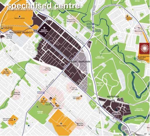
[NOTE: The Concept Masterplan as it relates to 29 Epping Road is consistent with the existing LEP
controls (21m proposed)].
Amending the RLEP 2010 Floor Space Ratio Map in accordance with the proposed floor space ratio
map, shown at Appendix D which indicates a maximum permissible floor space ratio of 2.4:1 for the
combined site.
PLANNING OUTCOMES
In summary, the site will achieve the following key planning outcomes with resultant community benefits:
The proposal is consistent with State government policy which supports growth within existing
centres: The proposal maximises commercial and residential opportunities in major centres well
serviced by public transport. It would generate new employment and housing opportunities creating
more than 880 new jobs (in addition to existing jobs within the site (within Domayne / Harvey
Norman)) and approximately 160-170 new dwellings.
Reinforcing the viability of North Ryde train station: by increasing development activity in the vicinity
of the station.
Masterplanned and collaborative approach to planning the Macquarie Park Specialised Centre: A
collaborative process with the NRSUAP project team has facilitated the development of a cohesive
structure plan with land uses, building placement and road layout arrangements that are compatible
with development proposed on the adjacent lands.
Improved pedestrian access and connectivity: It provides an opportunity for improved pedestrian
access and connectivity through the Macquarie Park Specialised Centre through the creation of a
new local road that is consistent with Council’s strategic plan to establish a finer grain network within
Macquarie Park and interconnects with public spaces and circulation networks within the NRSUAP
site.
It provides opportunities for an integrated network of open spaces which are visually linked with
community uses proposed to be developed within the NRSUAP site.
Street activation: It involves the creation of a new urban square and local retail facilities that will
activate the streets and complement the proposed land uses on the NRSUAP site to encourage
pedestrian activity and vibrancy.
Residential amenity to existing properties on southern side of Epping Road is maintained. The design
and siting of new buildings has been informed by a comprehensive site analysis to ensure that
development will not result in adverse impacts on existing residential properties.
Flood management: The proposal will improve the current situation, supporting a flood-free
development that will improve the existing flooding condition affecting properties on the southern side
of Epping Road.
ASSESSMENT
The site has few environmental constraints that would restrict its future development in accordance with
this Planning Proposal. The existing traffic congestion within the local area is considered to be the most
significant issue which this Planning Proposal has considered and addressed. A traffic report has been
prepared by Traffix (Appendix B) which confirms that the traffic impacts associated with the proposal can
be suitably managed and that the road network will be able to cater for the additional traffic from the
proposed development. Of note, a comparison of the traffic impacts of the proposal and a scheme
compliant with the relevant FSR and height controls applicable to the site under draft LEP Amendment
No.1 has been undertaken. This analysis confirms that the traffic generated by the proposal is broadly
consistent with that generated by a scheme that complies with the relevant height and FSR controls
under Draft LEP Amendment No.1.
URBIS
SA4757_PLANNING PROPOSAL_MAY 2013 3
EXECUTIVE SUMMARY
An internal street network has been designed that will provide suitable access for future development and
importantly will improve the permeability of the precinct in which the site is located providing a direct
connection to the NRSUAP site to the east. The access arrangement proposed does not rely on land
outside the site boundaries and can be delivered without compromising the development of surrounding
lands.

Careful consideration has also been given to the potential overshadowing impacts of the proposal on
existing residential properties to the south (on the opposite side of Epping Road). Analysis of the shadow
impacts of the proposal has confirmed that compliance with applicable criteria can be achieved; access to
sunlight is maintained to existing residential properties to the south between 9.30am and 3pm in mid-
winter.

CONCLUSION
Following our extensive analysis of the site and its surrounding context, and the applicable State and
local planning policies, we believe there is an overwhelming public benefit of proceeding with this
Planning Proposal.

The Planning Proposal supports the State government’s current direction of increasing density in major
centres and broadening land uses in the south-eastern end of Macquarie Park. Accordingly, the proposal
achieves the right balance of maintaining a strong employment focus while also recognising the benefits
of providing limited residential development to take advantage of the locational and amenity benefits this
part of the Centre can provide. This proposal therefore will not dilute the overarching goal of growth
employment in Macquarie Park. According to Council’s own analysis there is abundant potential for jobs
growth within the current and planned new zoning controls to meet State government targets.

Therefore we recommend that this Planning Proposal be favourably considered by Council; that Council
resolve to forward it to the Department of Planning and Infrastructure to allow the Department of Planning
and Infrastructure to consider the Planning Proposal for Gateway Determination under Section 56 of the
Environmental Planning and Assessment Act, 1979.

4 EXECUTIVE SUMMARY
                                                                                                              URBIS
                                                                                   SA4757_PLANNING PROPOSAL_MAY 2013
1 Introduction
This Planning Proposal has been prepared by Urbis (on behalf of the Harvey Norman Group (“the
applicant”)) to initiate the preparation of a Local Environmental Plan (LEP) to rezone land at 111 Wicks
Road, 29 Epping Road and 31-35 Epping Road, Macquarie Park (“the site”).
The proposal is to establish revised site specific floor space ratio (FSR) and height controls and rezone a
small part of the site to allow for mixed use development (including residential use on part of the site).
The site is currently zoned B3 Commercial Core and B7 Business Park under Ryde Local Environmental
Plan 2010 (RLEP 2010). The applicable built form controls that currently apply to the site include:
Height of buildings: 30 metres (maximum).
Floor space ratio: 1.5:1.
LEP Amendment No. 1, which was reported to Council in April and will subsequently exhibited, supports
an increase in the floor space ratio (FSR) control applicable to the site to 2:1 and an increase in building
height to 45m.
Two amendment options to RLEP 2010, to allow high density mixed use development on the site, are
proposed for consideration by Council:
Amend the land use zoning and the height of buildings and floor space ratio controls applicable to the
site to allow for high density development including commercial, bulky goods retail, hotel, retail and
residential development; or
Alternatively, include the subject site in RLEP 2010 by inserting an additional clause within Schedule
1 to permit high density development including commercial, bulky goods retail, hotel, retail and
residential development on the site.
The Planning Proposal has been prepared in accordance with Section 55 of the Environmental Planning
and Assessment Act 1979 (the EP&A Act) and the relevant guidelines prepared by the NSW Department
of Planning and Infrastructure including A Guide to Preparing Local Environmental Plans and A Guide to
Preparing Planning Proposals. It includes the following:
Description of the subject site and its context.
Indicative site plan showing sufficient detail to indicate the effect of the proposal (concept
masterplan).
Statement of the objectives and intended outcomes of the proposal.
Explanation of the provisions of the proposal.
Summary of the justification of the proposal.
Description of the community consultation process that would be undertaken by the proponent.
The Planning Proposal is accompanied by a range of plans and reports to provide a comprehensive
analysis of the site opportunities and constraints. These include:
Urban Design.
Traffic.
Civil and Structural Planning.
Each of the above plans and reports has informed the proposed rezoning of the site to allow for high
density mixed use development under the provisions of a site specific LEP.
URBIS
SA4757_PLANNING PROPOSAL_MAY 2013 INTRODUCTION 5This page is intentionally blank
6
INTRODUCTION
URBIS
SA4757_PLANNING PROPOSAL_MAY 20132 Land to which the Planning Proposal applies
2.1 SITE DESCRIPTION
The Planning Proposal relates to an irregular shaped parcel of land which comprises three landholdings
(all within the control of the applicant) as described in Table 1 and shown in the site aerial photograph in
Figure 2.
The site comprises an area of approximately 1.97 hectares. It is highly accessible within Macquarie Park
and the wider Sydney area given the presence of regional train, bus and road networks. Consequently it
has convenient access to a wide range of employment, retail, entertainment, medical, education, cultural,
sporting, recreation and other services and amenities. The site therefore has all the ingredients to be a
highly attractive location for commercial office and hotel operations as well as residents.
FIGURE 1 – SITE DESCRIPTION
TABLE 1 – SITE DESCRIPTION
EXISTING USE PROPERTY ADDRESS LEGAL DESCRIPTION SITE AREA
1 Industrial warehouse 111 Wicks Road Lot 10 DP1046090 9,805m2
Access road
2
2 Domayne store (bulky goods 31-35 Epping Road Lot 1 DP1151499 7,718m
retail)
2
3 North Ryde Smash Repairs 29 Epping Road Lot 2 DP 528488 2,240m
2
TOTAL: 19,763m
URBIS
SA4757_PLANNING PROPOSAL_MAY 2013 LAND TO WHICH THE PLANNING PROPOSAL APPLIES 72.2 EXISTING DEVELOPMENT
FIGURE 2 – SITE PLAN
1
2
3
The key existing features of the land to which the Planning Proposal applies are illustrated in Figure 2 and
described below:
Topography: The site has been heavily modified to facilitate its current use. The site slopes from
south to north. Levels vary from a high point in the south of RL52.11m to a low point of RL43.75m in
the north.
Site Layout and Built Form: An Urban Design report has been prepared by Allen Jack + Cottier which
describes the existing features of the site. A copy of the report is submitted with the Planning
Proposal (Appendix A). The site is fully developed and comprises a range of buildings which
accommodate a mix of industrial and bulky goods retail uses as follows:
1) 111 Wicks Road: Built development occupies the eastern side of this site and consists of a single
storey industrial warehouse / showroom and associated car parking (40 spaces). The western
portion of the site consists of an access handle connecting to Wicks Road.
2) 31-35 Epping Road: This portion of the site comprises two distinct sections: (1) Domayne /
Harvey Norman store situated immediately adjacent to Epping Road; and (2) a triangular shaped
parcel of land to the rear of the site consisting of landscaping.
3) 29 Epping Road: Built development comprises a small single storey warehouse building occupied
by a panel beaters workshop (North Ryde Smash Repairs). The site has direct vehicle access
from Epping Road.
Landscape: The site is fully developed and sparsely vegetated. Existing vegetation is limited to
landscaping along the site boundaries and road frontages.
Vehicle Access: A transport report has been prepared by Traffix which describes the existing local
traffic context, including existing access arrangements. A copy of the report is submitted with the
Planning Proposal (Appendix B). The main vehicle entry and car park for 111 Wicks Road are
accessed via a private lane / access handle off Wicks Road. The access handle also provides
delivery access for the adjacent Officeworks site to the west. The access handle is included within the
site boundary and would be improved to form a public road facilitating access through the site and
connecting into the street network being created within the adjacent NRSUAP site.
8 LAND TO WHICH THE PLANNING PROPOSAL APPLIES
URBIS
SA4757_PLANNING PROPOSAL_MAY 2013The Domayne / Harvey Norman store and 29 Epping Road adjacent are accessed from Epping Road
via a dedicated slip lane which also serves the adjacent Officeworks site. The access road lies
outside the site boundary.
Pedestrian Access: Pedestrian access is available via footpaths along the road verges but
permeability through the site is extremely poor. An existing footbridge is located immediately adjacent
to the site on Epping Road.
Easements and Encumbrances: A railway tunnel corridor associated with the Epping to Chatswood
Rail Line (ECRL) runs beneath the north eastern corner of the site and is protected by an easement
in favour of Transport for NSW. The easement comprises two zones: (1) the first reserve and (2) the
second reserve. Above and below ground works within these zones are subject to restrictions which
seek to prevent any potential encroachment on the rail corridor.
Officeworks has right of access over the Wicks Road access handle. The access handle is used by
servicing and delivery vehicles accessing the premises.
Flood Risk: The site is partly flood affected. Redevelopment will provide for the effective management
of stormwater flows across the site and has the potential to improve existing conditions both within
the site and on adjacent lands.
Acoustics: The key noise sources that may impact on the site include traffic noise most notably from
Epping Road and existing industrial operations. There are no existing residential properties within the
immediate vicinity of the site. The closest residences are to the south on the opposite side of Epping
Road.
Utility Services: The site is currently serviced by potable water, sewer, stormwater, electricity and
telecommunications, with potential for services upgrades as part of the proposed redevelopment.
The immediate surrounds comprise a variety of land uses which are described below:
North: The land immediately to the north comprises commercial office buildings and industrial
buildings further north.
East: The site is situated immediately adjacent to the NRSUAP site as described in Section 2.3.
West: Officeworks is located immediately to the west and comprises a warehouse style development
with main road frontage to Epping Road. Customer access to Officeworks is gained from the existing
slip lane on Epping Road. Servicing and delivery vehicles access the site from the rear via the Wicks
Road access handle.
South: Epping Road is immediately to the south and consists of a multi-lane road. The road separates
the site from low density housing opposite which generally comprises single storey detached
dwellings.
2.3 SURROUNDING CONTEXT
The site is located at the south-eastern edge of Macquarie Park. The area is well advanced in its
transition from older style light industrial / warehousing into a modern business park precinct incorporating
some high technology businesses. This transition is being supported by current development activity,
recent approvals, transport improvements and further planned development.
The key features of the surrounding area are generally summarised as follows:
Global Economic Corridor: Macquarie Park is an integral part of the Global Economic Corridor which
is an area of global economic activity stretching from Port Botany and Sydney Airport, through the
Sydney Central Business District (CBD), North Sydney and St Leonards to Parramatta. This region
accounts for the majority of Sydney’s globally oriented commercial businesses and over 50% of the
National Gross State Product. Macquarie Park will make a significant contribution to this, providing
61,000 jobs by 2031.
URBIS
SA4757_PLANNING PROPOSAL_MAY 2013 LAND TO WHICH THE PLANNING PROPOSAL APPLIES 9 Transport infrastructure: The site is closely situated to the intersection of Epping Road and the M2
motorway. Epping Road connects to Epping in the west and the M2 motorway to the east which
continues on to the Sydney CBD and also provides a direct connection to the North West Growth
Centre.
Public transport services to Macquarie Park are well established. High frequency bus connections
operate along Epping Road (bus stops are located to the front of the site), Herring Road and
Waterloo Road providing direct services to Chatswood, Epping, Parramatta, North Sydney and
Sydney CBD. There are also three new railway stations (Macquarie Park, Macquarie University and
North Ryde (adjacent to the subject site). Regular train services to Chatswood and the Sydney CBD
are available from these stations.
Development trends within Macquarie Park:
Increased density and scale: Recent development has redefined the character of the area and
this will continue to evolve over the coming years in line with State government policies for the
area (as articulated in the Metro Plan and the Subregional Strategy). New higher density
development has been approved as illustrated in Table 2 (locations shown in Figure 3).
TABLE 2 – LOCAL DEVELOPMENT
SITE FLOOR SPACE RATIO HEIGHT DWELLINGS
1. Stamford
110-114 Herring Road:
Concept Plan (as approved) 2.05:1 8 - 20 storeys 652 (approved)
Section 75W modification (under 2.28:1 5 – 22 storeys
assessment
2. Macquarie Central
120-124 Herring Road 2.64:1 9 – 12 storeys 550
3. St Hilliers
Talavera Road 2:1 7 – 9 storeys 232
6. TCA Site
North Ryde UAP (public exhibition) Maximum 4:1 4 – 32 storeys 2,500
Residential use: The character of Macquarie Park is evolving from a purely employment based
hub to support a more diverse range of uses. New development includes high density residential
uses which complement (rather than replace) its commercial focus and help to activate the
Centre outside business hours. New residential uses are generally concentrated at the northern
and southern ends of the Centre, focused around the Macquarie University and North Ryde train
stations. Recent approvals and current applications for residential development within and around
the Centre are shown in
Figure 3 over the page.
10 LAND TO WHICH THE PLANNING PROPOSAL APPLIES
URBIS
SA4757_PLANNING PROPOSAL_MAY 2013FIGURE 3 – MEDIUM AND HIGH DENSITY RESIDENTIAL DEVELOPMENT WITHIN MACQUARIE PARK
Urban Activation Precincts: State Government has recently announced 8 Urban Activation Precincts
(UAP), areas where land is available and has the potential for more intensive development by virtue
of access to infrastructure, transport, services and job. The UAPs will support a significant level of
new housing. Two of these UAPs (North Ryde Station and Herring Road) are located at the
northern and southern ends of Macquarie Park. As the development of these precincts progresses
they will reinforce the northern and southern ends of the Centre as mixed use zones which support
high density residential uses as well as commercial development. As illustrated in Figure 4 below, this
creates a “dumbbell effect,” i.e. two mixed use / high density residential zones at either end of the
Centre which frame the central commercial core and provide a transition to surrounding residential
development beyond.
FIGURE 4 – EASTERN AND WESTERN EXTENT OF MACQUARIE PARK CORRIDOR DEFINED BY MIXED USE
DEVELOPMENT
Subject Site
URBIS
SA4757_PLANNING PROPOSAL_MAY 2013 LAND TO WHICH THE PLANNING PROPOSAL APPLIES 11 North Ryde Station Urban Activation Precinct comprises approximately 14ha of primarily government
owned land and includes land surrounding North Ryde train station. The precinct is immediately to the
east of the subject site. Development planning to support the comprehensive redevelopment of the
precinct is at an advanced stage. Application documentation to support the rezoning and
establishment of a site specific planning regime for the Precinct is currently on public exhibition. The
primary aim of the proposal is to better activate the North Ryde train station, improve station access
and provide for a mixed use development that supports patronage of the train station and the ECRL
generally. The concept will support 2,500 new dwellings and 2,400 new jobs.
Figure 5 below identifies the boundary of the NRSUAP site and its relationship to the subject site.
FIGURE 5 – NORTH RYDE STATION PRECINCT SITE (EXTRACT FROM STATE SIGNIFICANT STUDY)
Subject site
12 LAND TO WHICH THE PLANNING PROPOSAL APPLIES
URBIS
SA4757_PLANNING PROPOSAL_MAY 2013SUMMARY In summary, the emergence of the UAPs in the Centre reinforces the structural composition of the centre as having two mixed use “ends” and a commercial core in the heart as illustrated in Figure 4. This Planning Proposal supports the state government’s current direction of increasing density and broadening land uses in the south-eastern end of Macquarie Park. Accordingly, this Planning Proposal achieves the right balance of maintaining a strong employment focus while also recognising the benefits of providing limited residential development to take advantage of the locational and amenity benefits this part of the Centre can provide. This proposal therefore will not dilute the overarching goal of growth employment in Macquarie Park. By Council’s own analysis there is abundant potential for jobs growth within the current and planned new zoning controls to meet state government targets. 2.4 PLANNING CONTEXT EXISTING PLANNING CONTROLS Ryde Local Environmental Plan 2010 (RLEP 2010) is the relevant planning instrument for the site. Under RLEP 2010, the site is zoned B3 Commercial Core. A small portion of the site (Wicks Road access handle) is zoned B7 Business Park. A plan showing the existing zones is provided at Figure 6. FIGURE 6 – EXISTING LAND USE ZONE The development standards under RLEP 2010 that are applicable to the majority of the site include: Floor Space Ratio – Maximum 1.5:1 (S1) Building Height – Maximum building height 30 metres (U1) The existing access handle in the eastern section of the site is subject to an FSR control of 1:1. No height control applies. URBIS SA4757_PLANNING PROPOSAL_MAY 2013 LAND TO WHICH THE PLANNING PROPOSAL APPLIES 13
FIGURE 7 – RELEVANT DEVELOPMENT CONTROLS

PICTURE 1 – FLOOR SPACE RATIO                        PICTURE 2 – HEIGHT

DRAFT LEP AMENDMENT NO.1
City of Ryde Council is in the process of making significant changes to increase the density of the
controls which apply to Macquarie Park. An amendment to RLEP 2010 (draft LEP Amendment No. 1) has
been given gateway approval from the DP&I and will be on public exhibition shortly for the final time
before the policy change is implemented.

The purpose of draft Amendment No. 1 is to provide substantial uplift in floor space across Macquarie
Park in recognition of the objectives identified in the Sydney Metropolitan Plan, the draft Inner North
Subregional Strategy and the City of Ryde Local Planning Study 2010 and to support the substantial
infrastructure requirements needed to support the increase in residents and workers.

Draft LEP Amendment No.1 proposes bonus height and FSR incentives for sites within the Macquarie
Park Specialised Centre, including the subject site, in exchange for contributions towards roads and open
space delivery. The amendment allows for incentive / bonus floor space of up to 2:1 and a height of 45m
in exchange for the relevant monetary contributions (via a Voluntary Planning Agreement) to support
local infrastructure provision. Once adopted the relevant standards for the Macquarie Park contained
within draft LEP Amendment No. 1 would be included in the draft RLEP 2011. The draft amendment has
been reported to Council and is expected to be publicly exhibited at the end of April 2013.

14  LAND TO WHICH THE PLANNING PROPOSAL APPLIES
                                                                                                               URBIS
                                                                                    SA4757_PLANNING PROPOSAL_MAY 2013
3 Planning Proposal Overview This Planning Proposal has been prepared in accordance with Sections 55(1)and (2) of the Environmental Planning and Assessment Act 1979 with consideration of the relevant guidelines, namely “A guide to preparing planning proposals” issued by the Department of Planning and Infrastructure (April 2013). Accordingly, the proposal is discussed in the following four parts: Part 1 – A statement of the objectives or intended outcomes. Part 2 – An explanation of the provisions that are to be included in the proposed LEP. Part 3 – The justification for the planning proposal and the process for the implementation. Part 4 – Details of community consultation that is to be undertaken for the planning proposal. Discussion for each of the above parts is outlined in the following chapters. URBIS SA4757_PLANNING PROPOSAL_MAY 2013 PLANNING PROPOSAL OVERVIEW 15
This page is intentionally blank

16
 PLANNING PROPOSAL OVERVIEW
                                                                                            URBIS
                                                                 SA4757_PLANNING PROPOSAL_MAY 2013
4 Part 1 – Objectives or Intended Outcomes
4.1 OBJECTIVES
The primary objective of the proposed rezoning is the creation of a high quality mixed use development
that, alongside the redevelopment of the NRSUAP lands, will make a meaningful contribution to the
growth of Macquarie Park. This will be achieved by:
Providing compatible land uses that will create a vibrant and active community, including residential
and commercial.
Integrating the site with the broader local community through improved pedestrian and vehicular
connections with the adjoining established commercial and residential areas and planned mixed use
areas.
Avoiding unacceptable impacts on the character and amenity of surrounding residential development
by generally locating increased density and building heights away from existing residential dwellings
to the south.
Utilising the established physical and social infrastructure which currently services the site and
adjacent urban areas.
Future development of the land is to be guided by the detailed principles outlined within the Urban Design
Report prepared by Allen Jack + Cottier and as summarised below:
Pedestrian and bicycle connectivity: promote walking and cycling and therefore reduce car trips and
facilitate public transport use:
Introduction of a high level of permeability and increased connectivity through the site by creating
a new network of public roads and an urban square.
Introduction of pedestrian crossings at key locations to improve existing pedestrian connections
through the site to and from North Ryde train station.
Vehicle connectivity: maximise site permeability and vehicular connections to the site:
Creation of a new public road connecting to Wicks Road consistent with the requirements of City
of Ryde DCP 2010.
Modification of existing slip road on Epping Road to facilitate access to the site.
Creation of a one-way driveway located between the existing Domayne / Harvey Norman store
and the proposed commercial building fronting Epping Road. The driveway will extend from
Epping Road and connect into the new public road.
Creation of a logical street network through the site forming an extension of the existing public
road network.
Vehicle access to the Domayne / Harvey Norman store will remain unchanged.
Open space: provide a diversity of open spaces within walking distance of proposed dwellings. A
central urban square complemented by a park will provide a focal point for the neighbourhood and
responds to the proposed development of community uses on the adjacent NRSUAP site.
View corridor and views: create a view corridor through the site to proposed open space within the
adjoining site and arrange built form to allow views to Lane Cove National Park, Chatswood and
Sydney CBD.
URBIS
SA4757_PLANNING PROPOSAL_MAY 2013 PART 1 – OBJECTIVES OR INTENDED OUTCOMES 17 Solar access: ensure that built form does not unreasonably impact on solar access by:
Maintaining solar access to proposed urban square between 12pm and 2pm in midwinter.
Maintaining solar access to existing residential properties between 9.30am and 3pm in midwinter.
Use: Incorporate uses that are compatible with and will contribute to the objectives for the NRSUAP
site.
Ecologically Sustainable Development: Achieve best practice in sustainable design.
Flood management: The proposal will improve the current situation, supporting a flood-free
development that will improve the existing flooding condition affecting properties on the southern side
of Epping Road.
4.2 INTENDED OUTCOMES
The intent of the Planning Proposal is:
“To allow high density mixed use development comprising commercial, retail, hotel and
residential development on Lot 10 in DP1046090, Lot 2 in DP528488 and Lot 1 in DP151499.”
Two options are proposed for consideration to allow high density mixed use development on the site as
follows:
Amend the land use zoning and the height of buildings and floor space ratio controls applicable to the
site to allow for high density development including commercial, bulky goods retail, hotel, retail and
residential development; or
Alternatively, include the subject site in Schedule 1 to permit high density development including
commercial, bulky goods retail, hotel, retail and residential development on the site.
The intended outcome of the Planning Proposal is to facilitate the timely delivery of the redevelopment of
the site to accommodate a high quality mixed use scheme that successfully integrates with the adjoining
NRSUAP development.
PROPOSED CONCEPT MASTERPLAN
To assist in conceptualising the character of the envisaged development, a Concept Masterplan has been
prepared by Allen Jack + Cottier which identifies the potential opportunities associated with the
redevelopment of the site. The approach would allow the site to be developed independently. It does not
rely on access from adjoining lands.
The 1.97 hectare site has a potential developable area of 6,795m 2. The balance of the site would
accommodate open, landscaped spaces and public roads.
Land Use
The key elements proposed are described below:
TABLE 3 – SUMMARY OF PROPOSED DEVELOPMENT
ELEMENT 111 WICKS ROAD 31-35 EPPING ROAD 29 EPPING ROAD
Land Use Residential Commercial Commercial
Hotel Bulky goods retail
Café
18 PART 1 – OBJECTVES OR INTENDED OUTCOMES
URBIS
SA4757_PLANNING PROPOSAL_MAY 2013ELEMENT 111 WICKS ROAD 31-35 EPPING ROAD 29 EPPING ROAD
Indicative yield Approx. 160-170 apartments:
1 bed units – 40%
2 bed units – 55%
3 bed units – 5%
Approx. 200 hotel rooms
2 2 2
Gross Floor Area Residential – 14,840m Commercial – 11,289m Commercial – 3,188m
2 2
Hotel – 9,144m Bulky goods – 8,663m
2
Café – 150m
2
Total Floor space: 47,274m
Floor Space Ratio 2.4:1
Built Form Distinctive triangular shaped Existing Domayne / Harvey 6 storey office building aligned
building. Norman store retained with with existing building frontage.
new 8 storey addition to the
Single storey retail premises rear of the building.
complemented by an urban
square.
Building Heights 23-27 storeys (89m) 3 / 12 storeys (10 - 50m) 6 storeys (21m)
Single storey café (5m)
FIGURE 8 – INDICATIVE BUILDING ENVELOPES
URBIS
SA4757_PLANNING PROPOSAL_MAY 2013 PART 1 – OBJECTIVES OR INTENDED OUTCOMES 19FIGURE 9 – CONCEPT MASTERPLAN
20 PART 1 – OBJECTVES OR INTENDED OUTCOMES
URBIS
SA4757_PLANNING PROPOSAL_MAY 2013Public Spaces
Publicly accessible open space will be integrated into the development concept as a defining element of
the visual character of the site and has been sited to form a logical extension to the network of open
space proposed within the NRSUAP site. Open space provision will include:
Urban Square and Park: Located at the northern end of the subject site this public square and an
adjoining park will provide a focus for the site and has the potential for community activities and
organised events.
Private Open Space: Private open space will be located in the northern portion of 31-35 Epping Road
directly opposite the proposed urban square and park. This space will provide an opportunity for
informal recreation and has the potential to provide a visual and physical link to the network of open
spaces proposed within the adjacent NRSUAP site.
Pedestrian Links: The proposed pedestrian network seeks to maximise the permeability and legibility
of the site. A central tree lined boulevard will form the main vehicular spine road through the site and
will connect entry points at Wicks Road and the adjacent site.
No changes are proposed to the existing pedestrian footbridge which extends across Epping Road
but improvements to the pedestrian environment on the northern side of Epping Road will improve the
useability of this footbridge.
FIGURE 10 – PROPOSED OPEN SPACE
URBIS
SA4757_PLANNING PROPOSAL_MAY 2013 PART 1 – OBJECTIVES OR INTENDED OUTCOMES 21Traffic, Access and Parking
The key transport and traffic measures proposed to accommodate the proposed rezoning and future
development of the site are described below:
FIGURE 11 – PROPOSED INTERNAL STREET NETWORK
Vehicle access: The primary access to the site is proposed from Epping Road (left in access only),
with secondary access from Wicks Road (north).
Epping Road: The existing service lane which facilitates access to properties within the block
fronting Epping Road will be upgraded. A new access driveway from the service lane would be
introduced between the existing Domayne / Harvey Norman store and the proposed commercial
building on Epping Road. The access driveway would provide one way access through the site
connecting to the new public road. The existing access to the Domayne / Harvey Norman site
would be retained allowing access to the Domayne / Harvey Norman store and proposed
commercial extension.
22 PART 1 – OBJECTVES OR INTENDED OUTCOMES
URBIS
SA4757_PLANNING PROPOSAL_MAY 2013 Wicks Road (north): The existing access to 111 Wicks Road will be upgraded to form a public
road which would extend through the site and connect with the new local road proposed as part
of the NRSUAP site proposal. Access would be restricted to left in left out vehicle movements to
prevent potential queues extending back to Epping Road.
Road layout: The internal road layout seeks to maximise the permeability and legibility of the site
through the creation of a central spine road extending from Wicks Road. The proposed road layout
will support pedestrian access to North Ryde train station to the east.
Bus stops: The existing bus stops on Epping Road immediately adjacent to the site will be retained.
Car parking: It is anticipated that future car parking rates will be determined by way of a site specific
development control plan that seeks to minimise car dependency and maximises the use of existing
public transport infrastructure while avoiding any unacceptable impacts on the street network and
surrounding areas. The car parking requirements of the proposal can be adequately met on-site
(basement parking).
Reduced sized copies of the drawings that outline the proposal are provided on the following pages.
A copy of the Concept Masterplan, including the Urban Design Report and accompanying drawings, is
submitted with the Planning Proposal.
Voluntary Planning Agreement
The applicant offers to enter into a Voluntary Planning Agreement (VPA) with Council to provide monetary
contributions (in addition to Section 94 contributions payable in respect of the proposed development) for
Council to use for planned capital works spending. These contributions could be used by Council for a
range of public purposes one of which may include the acquisition of land for a new public park on
Waterloo Road as identified in recent studies supporting LEP Amendment No. 1.
A copy of the offer to enter into a VPA with Council is appended to this document at Appendix E.
PREFERRED ALTERNATIVE CONCEPT PLAN
An assessment and analysis of site opportunities and constraints undertaken by the applicant, together
with analysis of the NRSUAP application documentation currently on public exhibition, concluded that
there is further potential to optimise the masterplanning of the site by further integrating the development
access with the adjoining NRSUAP lands.
Marginal adjustments to the site’s eastern site boundary would create a more logical site boundary for
both sites and enhance development potential. Therefore we have included for consideration, a longer
term “preferred alternative concept”.
This concept could be achieved through a land swap arrangement with TfNSW involving the transfer of
land within the subject site into the adjacent NRSUAP “M2 site” and vice versa. This approach would
further enhance the community benefits that could be achieved from the development of the lands by
simplifying access arrangements. The land swap arrangement would not impact on the overall size of the
site which would remain at approximately 1.97ha. It would involve the following (as illustrated in
Figure 12):
2
Transfer land within the north eastern and south eastern corners of the subject site (746m ) to the
NRSUAP site.
2
Incorporate a triangular shaped parcel of land (746m ) currently within the boundaries of the
NRSUAP site into the subject site.
Based on this potential site boundary, an alternative concept for the subject site has been explored (“the
Preferred Alternative Concept”). This option has been presented within this Planning Proposal for
information.
URBIS
SA4757_PLANNING PROPOSAL_MAY 2013 PART 1 – OBJECTIVES OR INTENDED OUTCOMES 23FIGURE 12 – PREFERRED ALTERNATIVE CONCEPT - SITE BOUNDARY
Land within control of
the applicant to be Land within NRSUAP
transferred to NRSUAP P site to be incorporated
site into the subject site
24 PART 1 – OBJECTVES OR INTENDED OUTCOMES
URBIS
SA4757_PLANNING PROPOSAL_MAY 2013Land Use
The Preferred Alternative Concept is broadly consistent with the Concept Masterplan in terms of land use
mix and built form with the exception of development proposed on 29 Epping Road. A comparison of the
development mix and indicative floor space achievable under the two schemes is shown in Table 4.
TABLE 4 – COMPARISON OF PROPOSED DEVELOPMENT UNDER CONCEPT MASTERPLAN AND PREFERRED
ALTERNATIVE CONCEPT
ELEMENT CONCEPT MASTERPLAN PREFERRED ALTERNATIVE CONCEPT
Commercial 8 Storey addition above the rear of the 8 Storey addition above the rear of the
existing Domayne / Harvey Norman existing Domayne / Harvey Norman store
store (three storey building). (three storey building).
6 storey building on 29 Epping Road.
Bulky goods retail Domayne / Harvey Norman store as Domayne / Harvey Norman store as
existing existing
Retail Neighbourhood facilities including Neighbourhood facilities including shops,
shops, cafes cafes
Residential accommodation 17 levels of apartments within 27 storey 17 levels of apartments within 27 storey
building. building.
Total Dwelling Yield: 160 - 170 12 storey residential apartment
apartments building on 29 Epping Road.
Total Dwelling Yield: 250 - 260
apartments
Hotel Lower 10 levels of 27 storey building. Lower 10 levels of 27 storey building.
200 rooms 200 rooms
Child care centre N/A Potential for child care centre at
ground floor level of residential
apartment building on 29 Epping Road.
Gross Floor Area 47,274m2 49,417m2
- Commercial 2 2
14,477m 10,860m
- Hotel 2 2
9,144m 9,144m
- Bulky goods retail 8,663m2 8,663m
2
(existing)
- Residential 2 2
14,840m 20,120m
- Cafe 2 2
150m 150m
- Childcare Centre N/A 480m2
URBIS
SA4757_PLANNING PROPOSAL_MAY 2013 PART 1 – OBJECTIVES OR INTENDED OUTCOMES 25FIGURE 13 – PREFERRED ALTERNATIVE CONCEPT
Single consolidated vehicle access point
off Epping Road
Potential new landscaped
feature entry to precinct
26 PART 1 – OBJECTVES OR INTENDED OUTCOMES
URBIS
SA4757_PLANNING PROPOSAL_MAY 2013You can also read