M2 Junction 5 Improvements Highways England Statement of Case - In respect of Orders under Provisions of the Highways Act 1980
←
→
Page content transcription
If your browser does not render page correctly, please read the page content below
M2 Junction 5 Improvements

    Highways England Statement of Case

In respect of Orders under Provisions of the Highways
                                            Act 1980
                                           October 2019
M2 Junction 5 Improvements
Highways England Statement of Case

                                 STATEMENT OF CASE

                                         for

      THE HIGHWAYS ENGLAND (A249 TRUNK ROAD STOCKBURY
                 ROUNDABOUT IMPROVEMENTS)

                     COMPULSORY PURCHASE ORDER 2019

                                         and

      THE HIGHWAYS ENGLAND (A249 TRUNK ROAD STOCKBURY
                 ROUNDABOUT IMPROVEMENTS)

                             (SIDE ROADS) ORDER 2019

                                         and

        THE A249 TRUNK ROAD (A249 TRUNK ROAD STOCKBURY
                   ROUNDABOUT IMPROVEMENTS)

                                     ORDER 20[..]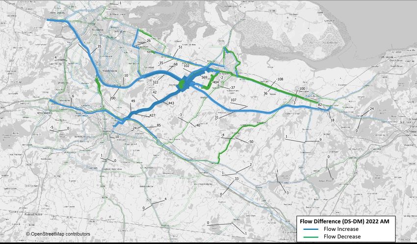
M2 Junction 5 Improvements
Highways England Statement of Case

Table of contents
Chapter                                               Pages
1.    Introduction                                        1
1.1   Overview                                            1
1.2   The Scheme                                          1
1.3   Secretary of State’s Responsibilities               2
2.    Background                                          3
3.    Environmental Assessment of the Scheme              7
3.1   Introduction                                        7
3.2   Summary of the environmental assessment             7
4.    Traffic and Economic Assessment of the Scheme      13
4.1   Introduction                                       13
4.2   The strategic traffic model                        13
4.3   Operational model assessment                       27
4.4   Economic performance of the Scheme                 28
5.    The Orders                                         31
5.1   The Planning Position                              31
5.2   The Compulsory Purchase Order                      31
5.3   The Line Order                                     33
5.4   The SRO                                            33
6.    The Case for Compulsory Acquisition                36
6.1   Introduction                                       36
6.2   Compelling case in the public interest             36
6.3   Government Transport Policy                        40
6.4   Acquisition of Land & Rights by Agreement          50
6.5   Summary                                            54
7.    Special Considerations                             54
7.2   Statutory undertaker apparatus and land            55
7.3   Kent Downs Area of Outstanding Natural Beauty      56
8.    Objections and Representations                     57
8.1   Summary                                            57
8.2   Responses of support                               58
8.3   Statutory Objections                               59
8.4   Non-Statutory Objections                           68
8.5   Representations                                    74
8.6   General Enquiries                                  78
9.    Specialist Evidence and Deposit Documents          79
9.1   Proofs of Evidence                                 79
9.2   Proofs of Evidence                                 79
                                                          iii
M2 Junction 5 Improvements
Highways England Statement of Case

Appendices                                                                                                                                         80

Appendix 1 – Deposit Documents
Appendix 2 – Status of negotiations with landowners

Tables
Table 4.1 Journey time - AM peak ................................................................................................................... 24
Table 4.2 Journey time - Inter Peak ................................................................................................................ 25
Table 4.3 Journey time - PM peak ................................................................................................................... 26
Table 4.4 Network performance results – AM peak hour ................................................................................ 27
Table 4.5 Network performance results – PM peak hour ................................................................................ 28
Table 6.1: Accidents and Casualties over Appraisal Period............................................................................ 38

Figures
Figure 4.1 Cordoned model area ..................................................................................................................... 14
Figure 4.2 Flow Difference Between DS and DM - 2022 AM (Veh/hr) ............................................................ 17
Figure 4.3 Flow Difference Between DS and DM - 2022 IP (Veh/hr) .............................................................. 18
Figure 4.4 Flow Difference Between DS and DM - 2022 PM (Veh/hr) ............................................................ 19
Figure 4.5 Flow Difference Between DS and DM - 2037 AM (Veh/hr) ............................................................ 20
Figure 4.6 Flow Difference Between DS and DM - 2037 IP (Veh/hr) .............................................................. 21
Figure 4.7 Flow Difference Between DS and DM - 2037 PM (Veh/hr) ............................................................ 22
Figure 4.8 Journey Time Routes ..................................................................................................................... 23

                                                                                                                                                    iv
M2 Junction 5 Improvements
Highways England Statement of Case

Glossary of terms and abbreviations
  Abbreviation      Definition

   ALA               Acquisition of Land Act
   AM                Ante meridiem
   AMMS              Archaeological Mitigation and Management Strategy
   AoNB              Area of Outstanding Natural Beauty
   ARN               Affected Road Network
   AQMA              Air Quality Management Areas
   AW                Ancient Woodland
   BCR               Benefit to Cost Ratio
   BMV               Best and Most Versatile
   BT                BT Group plc
   CEMP              Construction Environmental Management Plan
   CPO               Compulsory Purchase Order
   DCLG              Department for Communities and Local Government
   DfT               Department for Transport
   DM                Do Minimum
   DMRB              Design Manual for Roads and Bridges
   DS                Do Something
   DVS               District Valuer Services
   D2                Dual 2 lane
   D2AP              Dual 2 lane all purpose
   D3                Dual 3 lane
   D4                Dual 4 lane
   D2M               Dual 2 lane motorway
   ECHR              European Convention on Human Rights
   EIA               Environmental Impact Assessment
   ES                Environmental Statement
   GA                General Arrangement
   GPDO              General Permitted Development Order
   ha                Hectare
   HA                Highways Act
   HE                Highways England
   IAN               DMRB Interim Advice Note
   IP                Inter peak period
   KCC               Kent County Council
   KMBRC             Kent and Medway Biological Records Centre
   LED               Light-Emitting Diode
   LTAM              Lower Thames Area transport Model
   LTC               Lower Thames Crossing
                                                                         v
M2 Junction 5 Improvements
Highways England Statement of Case

  Abbreviation      Definition

   MCCF              Maidstone Cycle Campaign Forum
   MHCLG             Ministry of Housing, Communities and Local Government
   NIA               Noise Important Areas
   NMU               Non-motorised user
   NN NPS            National Networks National Policy Statement
   NPPF              National Planning Policy Framework
   NPV               Net Present Value
   NO2               Nitrogen Dioxide
   NRSWA             New Roads and Street Works Act (1991)
   NRTS              National Roads Telecommunications Services
   NSIP              Nationally Significant Infrastructure Project
   OEMP              Outline Environmental Management Plan
   PM                Post meridiem
   PRoW              Public Right of Way
   PVB               Present Value of Benefits
   PVC               Present Value of Costs
   REAC              Register of Environmental Actions and Commitments
   RNR               Roadside Nature Reserve
   RIS               Road Investment Strategy
   RSA               Road Safety Audit
   SAC               Designated Special Area of Conservation
   SAR               Scheme Assessment Report
   SATURN            Simulation and Assignment of Traffic in Urban Road Networks
   SPA               Special Protection Areas
   SRN               Strategic Road Network
   SRO               Side Roads Order
   SSSI              Sites of Special Scientific Interest
   S2                Single carriageway
   TUBA              Transport User Benefit Analysis
   Veh/hr            Vehicles per hour
   WebTAG            Web based Transport Analysis Guidance
   WFD               Water Framework Directive

                                                                                   vi
M2 Junction 5 Improvements
Highways England Statement of Case

1.        Introduction
1.1       Overview
1.1.1     This Statement of Case relates to the M2 Junction 5 Improvements (the
          "Scheme") and the Orders that were submitted by Highways England Company
          Limited (the "Applicant") to the Secretary of State for Transport (the "Secretary
          of State") on 13th June 2019. It relates to the making of the following orders:

          •   The Highways England (A249 Trunk Road Stockbury Roundabout
              Improvements) Compulsory Purchase Order 2019 (the "CPO");
          •   The Highways England (A249 Trunk Road Stockbury Roundabout
              Improvements) (Side Roads) Order 2019 (the "SRO"); and
          •   The A249 Trunk Road (Stockbury Roundabout Improvements) Order 20[..]
              (the "Line Order"),
          together, the "Orders"
1.1.2     The decision on whether the Scheme will be subject to a Public Inquiry is made
          by the Secretary of State. A notice was issued by the Department for Transport
          on 30th August 2019 confirming that the Secretary of State intends to hold a
          Public Local Inquiry.

1.1.3     This Statement is provided pursuant to Rule 6 of the Highways (Inquiries
          Procedure) Rules 1994 (Appendix 1, E.1) and Rule 7 of the Compulsory
          Purchase (Inquiries Procedure) Rules 2007 (Appendix 1, E.2). It sets out the
          case that the Applicant will present at the Public Local Inquiry in support of the
          Orders, although the Applicant reserves the right to supplement the issues to be
          addressed and produce further documents and evidence in response to
          submissions made by other parties to the Inquiry.

1.2       The Scheme
1.2.1     The Scheme is located within the administrative boundaries of Maidstone
          Borough Council and Swale Borough Council in Kent. Kent County Council is the
          planning authority for the area and the local highway authority. The Scheme is
          within the Stockbury Valley, approximately 5km south west of Sittingbourne,
          approximately 7.5km south east of Gillingham.

1.2.2     An indicative layout of the Scheme illustrating the works referred to in the
          following paragraphs is provided on the General Arrangement Drawings
          (Appendix 1, A.9 to A.15).

1.2.3     The Scheme comprises the following elements:

                                                                               Page 1 of 92
M2 Junction 5 Improvements
Highways England Statement of Case

        1.2.3.1   The replacement of the existing Stockbury Roundabout with a new grade-
                  separated junction;
        1.2.3.2   Stockbury Roundabout would remain at-grade and would be enlarged to
                  accommodate connections to the roundabout. The A249 mainline would
                  flyover the Stockbury Roundabout, with the approaches on embankments
                  and retaining walls, and with two single span bridges over the roundabout;
        1.2.3.3   Four new slip roads, three of which include dedicated left turn lanes at the
                  roundabout for the following turning movements:
                  •   A249 southbound to M2 westbound;
                  •   A249 northbound to M2 eastbound; and
                  •   M2 eastbound to A249 northbound.
        1.2.3.4   The existing Maidstone Road connection with Stockbury Roundabout will be
                  stopped up and a new Maidstone Road Link will be provided, connecting to
                  Oad Street to the north of the M2;
        1.2.3.5   A new link road will be provided between Stockbury Roundabout and Oad
                  Street, with the new link road connecting into Oad Street near the existing
                  junction of Oad Street and the A249. The existing Oad Street and A249
                  junction would be closed. Oad Street will remain open for local access to
                  properties but will not have direct access onto the A249 as currently exists.
                  The existing southbound lanes of the A249 will be retained south of the
                  existing junction with Oad Street and this will be converted into a two-way
                  single carriageway to provide continued access to properties and land
                  fronting onto this section of road and connection to South Green Lane; and
        1.2.3.6   The Honeycrock Hill junction with the A249 will be stopped up.

1.2.4       The works described above would be subject to specific mitigation requirements,
            for example, landscaping and environmental mitigation. These are set out in the
            Outline Environmental Management Plan (OEMP) and the Register of
            Environmental Actions and Commitments (REAC) and shown on the Preliminary
            Outline Environmental Design drawings, which are included as Figure 2.3 in the
            Environmental Statement Volume 2 (Appendix 1, B.3).

1.3         Secretary of State’s Responsibilities
1.3.1       The Applicant is the government-owned company charged with operating,
            maintaining and improving the strategic road network (motorways and trunk
            roads) in England on behalf of the Secretary of State.

1.3.2       The Applicant is the Highway Authority for the M2 Motorway including the
            sliproads and roundabout M2 Junction 5 Stockbury Interchange, as well as for
            the A249 Trunk Road north of the Stockbury roundabout. Kent County Council is
            the Highway Authority for the A249 south of the Stockbury Roundabout and all
            other public roads connecting at the junctions.

                                                                                Page 2 of 92
M2 Junction 5 Improvements
Highways England Statement of Case

2.        Background
2.1       Existing Conditions
2.1.1     The M2 is part of the Strategic Road Network (SRN) serving east-west
          movements between the Port of Dover and London and also serving major urban
          areas around Canterbury, Medway, Gravesham and Dartford. The A2/M2
          corridor ranges from being dual 3 lane (D3) and dual 4 lane (D4) carriageway
          standard in the west to predominantly dual 2 lane (D2) carriageway standard in
          the east. The M2 through the study area is currently dual 2 lane motorway
          standard (D2M).

2.1.2     The A249 provides a local and strategic route between Maidstone and the Isle of
          Sheppey, serving a number of smaller villages and Sittingbourne along the way.
          The A249 crosses the M20 and M2 routes. The A249 is generally to dual 2 lane
          all purpose (D2AP) carriageway standard except for single carriageway (S2)
          sections in Maidstone and on the Isle of Sheppey.

2.1.3     The A249 sits within a valley with ground elevations typically increasing relatively
          steeply on either side of the road. Access to the eastbound M2 is west off
          Stockbury Roundabout and access to the westbound carriageway is east off
          Stockbury Roundabout.

2.1.4     There are four other local access roads within the site area. Maidstone Road is
          accessible from Stockbury Roundabout and runs sub-parallel with the A249
          towards Sittingbourne. The other access routes are situated in the south eastern
          extent of the site area, providing access to occasional farm houses / residential
          properties.

2.1.5     Maidstone Road runs parallel to the A249 north of the roundabout and serves
          villages such as Danaway and Chestnut Street. It also provides a potential
          alternative route for traffic from the A2 and Sittingbourne during the peak
          periods. Maidstone Road is subject to a 50 mph restriction through Danaway and
          a 30 mph restriction through Chestnut St. There is also a 6’6’’ width restriction
          through Chestnut Street due to the narrow lanes.

2.1.6     Oad Street joins the A249 approximately 250m south of the roundabout, having
          served a number of small settlements and rural properties. Vehicles are currently
          allowed to turn both left and right out of Oad St, whilst only left turns in are
          enabled. The right out of Oad St involves a manoeuvre crossing the southbound
          dual carriageway, through the central reserve and joining the A249 north bound
          carriageway, which is a potential safety risk. Oad St provides an alternative route
          into the southern side of Sittingbourne and therefore has traffic calming
          measures installed in the hamlet of Oad Street (parish of Borden).

                                                                               Page 3 of 92
M2 Junction 5 Improvements
Highways England Statement of Case

2.2       Scheme History
2.2.1     A study undertaken by Highways England in July 2009 identified capacity issues
          at the M2 J5 and the need for long term solutions to accommodate future
          planned development. Further work was undertaken in September 2012, which
          considered options for improvements and looked at fundable capacity
          enhancements for M2 J5.

2.2.2     The performance of the M2 was considered in Highways England’s Kent
          Corridors to M25 Route Strategy. In addition to existing capacity constraints at
          the junction, it was also identified as being joint 10th out of the top 250 collision
          locations nationally for the total number of casualties per billion vehicle miles for
          the period 2009-2011.

2.2.3     A commitment to undertake a detailed improvement study at M2 J5 was made as
          part of the 2014 Autumn Statement, and subsequently detailed in the
          Department for Transport’s (DfT) Road Investment Strategy (RIS). The RIS
          (December 2014) included an investment of between £50m - £100m for
          improvements to M2 J5.

2.2.4     Highways England established their investment priorities for the Kent Corridor in
          March 2015. It was identified that the M2 at junction 5 would benefit from
          improvements to increase capacity to assist the delivery of residential and
          employment growth.

2.3       Alternatives Considered
2.3.1     The Scheme Assessment Report (May 2018) (Appendix 1, C.3) describes how
          twelve options for improving road capacity at the junction were identified,
          assessed and sifted during Stages 0, 1 and 2. Only one option was considered
          to be a viable solution. This, along with three other discounted options, were
          presented at a Public Consultation in September/October 2017.

2.3.2     The consultation resulted in 518 questionnaire responses, with 47 further written
          responses from stakeholders and the public. A total of 1,307 people visited the
          public consultation exhibitions. There was overwhelming support for a scheme at
          the junction with 94% of respondents agreeing that something needs to be done.

2.3.3     However, there was little support for the proposed solution with 68% of the
          general public not supporting this option. The local MP, Local Authorities and
          South East Local Enterprise Partnership expressed a preference for an
          alternative option that included the grade-separation of the A249 at Stockbury
          roundabout with a flyover.

2.3.4     Highways England therefore undertook a review of the rejected flyover option
          presented during the public consultation to determine if there were opportunities
          to reduce the cost of the scheme, whilst maintaining the benefits of this option.

                                                                                 Page 4 of 92
M2 Junction 5 Improvements
Highways England Statement of Case
2.3.5 As a result, a revised flyover scheme, was developed, and presented as the
Preferred Route in May 2018.
2.4 Need for and Benefits of the Scheme
2.4.1 The Scheme forms part of the Department for Transport (DfT) and the Highways
England (HE) Regional Investment Programme (RIP) and is needed to primarily
address the capacity and performance deficiencies of the junction. The approach
to the junction experiences high levels of delay and the junction is included on
the list of the top 50 national casualty locations on the England's major 'A' roads
and motorways network. The upgrades are required to increase the capacity of
the network to accommodate traffic from planned new developments.
2.4.2 The M2 Junction 5 has capacity constraints resulting in unsatisfactory network
performance. This affects M2 east-west movements and A249 north-south
movements between Sittingbourne and Maidstone, with current traffic demands
significantly exceeding capacity. In particular, the approach to the junction from
the east experience’s high levels of delay.
2.4.3 The Scheme is required to provide for planned residential and commercial
development. Swale Borough Council is planning for an additional 14,124
dwellings and 130,000m2 of employment land up to 2031 (Swale Borough
Council, 20171). This scale of development is expected to have a significant
impact on the performance of the M2 Junction 5. Growth plans set out in the
Local Economic Partnerships' Strategic Economic Plan2 are likely to be inhibited
by a lack of capacity at this junction. In addition, the Kent Corridors to M25 Route
Strategy Evidence Report (Highways Agency, 2014) identified that more efficient
operation of the M2 Junction 5 would be essential to secure the economic
development potential of the area.
2.4.4 The Scheme is also required due to safety concerns, as identified during the
route-based strategy sifting process. The M2 Junction 5 is one of the top 50
national casualty locations on England's major 'A' roads and motorways, and one
of the main areas within the Kent Corridors to M25 Route Strategy Evidence
Report3 which interacts with vulnerable road users. There were 111 personal
injury accidents recorded between January 2011 and December 2015, with
almost half of these occurring during the morning and evening peak periods.
2.4.5 Additionally, people travelling to and from the Maidstone area currently use the
rural Oad Street to avoid the congested M2 Junction 5. This puts pressure on the
local road network, which is not suited to large volumes of traffic and results in
increased safety risk.
1
Bearing Fruits 2031: The Swale Borough Local Plan 2017
2
Local Economic Partnerships' Strategic Economic Plan (South East Local Enterprise Partnership, 2014)
3
Kent Corridors to M25 Route Strategy Evidence Report, former Highways Agency, April 2014
Page 5 of 92M2 Junction 5 Improvements
Highways England Statement of Case
2.4.6 The commitment to undertake a detailed improvement study at the M2 Junction
5 was initially made as part of the 2014 Autumn Statement.4 This commitment
was subsequently confirmed in the DfT Road Investment Strategy (RIS). The
improvements will contribute to national transport objectives by:
• Providing additional capacity;
• Enhancing journey time reliability;
• Improving the safety of the M2 Junction 5 and surrounding local road network
for road users; and
• Supporting the development of housing and the creation of jobs.
2.4.7 Further information on the need for the Scheme, including details of the traffic
modelling, is included in Section 5 of this Statement and the Scheme
Assessment Report which was published at the Scheme Option Selection Stage.
2.5 Scheme Objectives
2.5.1 In line with the National Policy Statement for National Networks (NPSNN) and
the overarching objectives of the DfT RIS, the objectives of the Scheme are to:
• Support economic growth - To enhance the capacity, connectivity and
resilience provided by the M2 J5, in order to contribute positively to
strengthening the local and regional economic base, delivering housing
allocations within the Swale Local Plan and promoting economic growth
across the region;
• A safe network – To improve safety and security offered by M2 J5 to all road
users. By reducing the number of people killed or seriously injured (KSI) and
slight collisions;
• A more free-flowing network – To improve the journey quality and journey
time and reliability for all routes through M2 Junction 5; and
• An improved environment – To deliver a high standard of design for any
M2 J5 improvement that reflects the quality of the landscape and setting, and
that minimises the adverse environmental impact of new construction.
4
Autumn Statement 2014, HM Treasury, the Rt Hon Danny Alexander and the Rt Hon George Osbourne, 8 December
Page 6 of 92M2 Junction 5 Improvements
Highways England Statement of Case
3. Environmental Assessment of the Scheme
3.1 Introduction
3.1.1 An Environmental Statement assessing the environmental impact of the Scheme
was published with the Orders on 13 June 2019; a copy of the Environmental
Statement is included in the documents on deposit (Appendix 1, B.1 to B.4).
3.1.2 The full Environmental Statement comprises four volumes in total, as follows:
• The Environmental Statement Main Text setting out the environmental
assessment in chapters (Volume 1);
• The Environmental Statement Appendices (Volume 2);
• The Environmental Statement Figures, including drawings, photos and other
illustrative material (Volume 3); and
• The Environmental Statement Non-Technical Summary (Volume 4).
3.1.3 The following environmental topics have been assessed as part of the
Environmental Impact Assessment (EIA):
• Air Quality;
• Noise and Vibration;
• Biodiversity;
• Road Drainage and the Water Environment;
• Landscape and Visual;
• Geology and Soils;
• Cultural Heritage;
• Materials and Waste,
• Population and Human Health; and
• Climate.
3.1.4 The EIA has been undertaken by a team of specialists working in collaboration
with the design engineers responsible for the preliminary design of the Scheme.
This has maximised the opportunity to avoid or reduce environmental effects and
to identify the most effective mitigation of those effects that cannot be avoided.
3.1.5 The Scheme has been designed to avoid key environmental constraints as much
as possible.
3.1.6 The engineering and environmental designs will continue to be developed
through detailed design and will seek further opportunities to reduce or avoid
residual environmental impacts.
3.2 Summary of the environmental assessment
Air Quality
Page 7 of 92M2 Junction 5 Improvements
Highways England Statement of Case
3.2.1 There is one Air Quality Management Area (AQMA), where national air quality
objectives have been breached, within the air quality study area that could be
affected by changes in traffic with the Scheme. The Air quality assessment
considered the impacts of the Scheme during construction and operation.
3.2.2 During construction, there will be no significant effects with the implementation of
suitable mitigation measures outlined in the Outline Environmental Management
Plan (OEMP) in the Environmental Statement Volume 2 Appendix A.
3.2.3 During operation, there is not expected to be any exceedances of the NO 2
(Nitrogen Dioxide) annual mean objective at the human health receptors in the
opening year (with or without the Scheme). Four receptors are expected to have
a small increase in NO2 concentrations with the Scheme and all other receptors
are expected to experience an imperceptible change or small decrease in NO 2
concentrations, with one having a very large decrease due to the realignment of
the A249. There are not expected to be any exceedances of the PM10 objectives
with the Scheme. The Scheme is expected to result in an increase in NO x
concentrations at the Wouldham to Detling Escarpment Site of Special Scientific
Interest (SSSI), which overlaps with the North Downs Woodlands SAC SSSI,
although changes in nitrogen deposition rates are expected to be less than 0.1
kg/N/ha/year. In summary, during operation, the Scheme is not expected to have
a significant adverse effect on human health or ecological receptors.
Noise and Vibration
3.2.4 There are 119 residential properties and 2 non-residential properties within 600
m of the Scheme. There are a number of Defra Noise Important Areas (NIAs)
which are areas that have been identified as being subject to high levels of noise
located near the Scheme. The noise and vibration assessment considered the
impacts of the Scheme during construction and operation.
3.2.5 During construction, there will be potentially significant night time noise effects.
The frequency of these impacts will be reduced, if night time construction works
are limited to essential works only. Mitigation measures including best practice,
are identified in the OEMP in the Environmental Statement Volume 2 Appendix
A.
3.2.6 During operation, the Scheme will not have a significant adverse effect on any
residential properties including NIAs or at any non-residential sensitive receptors.
A significant beneficial effect is expected at a small number of properties,
including two NIAs. No significant noise effects are predicted for the Kent Downs
AONB.
Biodiversity
3.2.7 There are no statutory sites designated for nature conservation within the
Scheme. Queendown Warren Site of Special Scientific Interest (SSSI), North
Downs Woodlands Special Area of Conservation (SAC) and Wouldham to
Page 8 of 92M2 Junction 5 Improvements
Highways England Statement of Case
Detling Escarpment SSSI are located adjacent to the Affected Road Network
(ARN) for the Scheme5. There are two non-statutory sites designated for nature
conservation located within the Scheme area: Honeycrock Hill Roadside Nature
Reserve (RNR) and Church Hill, Stockbury RNR. Church Wood Ancient
Woodland (AW), Chestnut Wood AW and one veteran oak tree are located
adjacent to the Scheme.
3.2.8 The Scheme and immediately adjacent land comprise notable habitats including
hedgerows, traditional orchard, lowland mixed deciduous woodland, lowland
beech and yew woodland, lowland calcareous grassland as well as other
habitats including ponds, scrub, poor semi-improved grassland, tall ruderal,
species poor hedgerows, arable farmland and amenity grassland.
3.2.9 The Scheme and immediately adjacent land support notable and protected
species comprising of man orchid colonies, notable species of pyramidal orchid
and bee orchid, roosting, foraging and commuting bats, hazel dormice, notable
birds, reptiles (common species), and terrestrial invertebrates. The non-native
invasive plant species cotoneaster is also present within the Scheme area.
3.2.10 The biodiversity assessment considered the impacts of the Scheme during
construction and operation.
3.2.11 During construction, the assessment concluded that there will a slight adverse
temporary effect due to the direct loss of habitat within Honeycrock Hill RNR and
Church Hill, Stockbury RNR and on habitats including broadleaved semi-natural
woodland, plantation woodland, hedgerows and standing water until translocated
hedgerows, grassland and new planting become established. There will be a
moderate adverse temporary effect on the population of hazel dormice due to
habitat loss and disturbance. There will be no significant effects on other
designated sites, ancient woodland, the veteran tree, bats, reptiles, breeding and
wintering birds, terrestrial invertebrates and invasive non-native plant species
due to the mitigation measures incorporated into the Scheme.
3.2.12 During operation, once habitats are established, the Scheme is likely to result in
beneficial effects for habitats, hazel dormice and breeding and wintering birds
due to the improved quality of newly created habitats.
Road drainage and the water environment
3.2.13 There are no Main Rivers near the Scheme. The key water environment features
for the Scheme include an attenuation pond which forms part of the existing
surface water management system for the highway network and a small artificial
pond with no ecological value. The Scheme is within Flood Zone 1 (low flood
risk), underlain by the North Kent Swale Chalk groundwater body Water
Framework Directive (WFD), Principal Aquifer and a Secondary A Aquifer, and
5
The Affected Road Network is the parts of the road network surrounding the Scheme that may be affected by a change in traffic levels
as a result of the Scheme.
Page 9 of 92M2 Junction 5 Improvements
Highways England Statement of Case
Groundwater Source Protection Zones 1, 2 and 3. The assessment has
considered the effects of the Scheme during construction and operation.
3.2.14 During construction, there will be no significant effects, with the implementation
of mitigation measures, on surface water, flood risk, groundwater and WFD
compliance.
3.2.15 During operation, there will no significant effects with the implementation of
mitigation measures, on surface water, flood risk, groundwater and WFD
compliance.
Landscape and visual
3.2.16 The existing junction is largely screened by mature roadside vegetation, with the
existing M2 viaduct a noticeable feature in the local landscape. It lies partly
within the Kent Downs Area of Outstanding Natural Beauty (AONB) which is
renowned for its special characteristics, including: dramatic landform, panoramic
and long-ranging views, rich habitats, tranquillity, remoteness and built heritage.
The assessment has considered the effects of the Scheme during construction
and operation.
3.2.17 During construction, loss of existing screening vegetation due to construction
activities and building of structures and significant earth movements will lead to a
dynamic and disruptive character to the local landscape which will result in
increased visibility towards the Scheme and will exacerbate the impacts of the
construction works on nearby receptors. Significant effects on nearby landscape
character areas, various residential properties along Maidstone Road, the A249
and Oad Street, users of Public Rights of Way (PRoW) and transport receptors
are due to the loss of screening vegetation opening up views of the new
infrastructure.
3.2.18 During operation, views of the Scheme opened up during construction would
remain until the proposed mitigation planting has matured. The Scheme will have
led to the diversification of landscape elements within the soft estate of the
development, strengthening and enhancing fragmented field boundaries and
other fragmented landscape elements. The Stockbury Flyover will have been
sensitively designed using local, natural stone to respond to the sensitive setting
of the Kent Downs AONB. Although a significant local impact to the AONB is
anticipated at Operation Year 1, the Scheme would not impact upon the wider
extent of the Kent Downs AONB and design measures have been employed to
reduce the long-term visual and landscape impacts resulting from the Scheme in
its immediate context. At Operation Year 15, it is anticipated that mitigation
planting will have reached relative maturation and there will be no significant
residual effects on the landscape character areas. There will be a residual
significant effect upon the residential receptor Whipstakes Farm along Oad
Street.
Page 10 of 92M2 Junction 5 Improvements
Highways England Statement of Case
Geology and soils
3.2.19 The assessment has considered the effects of the Scheme during construction
and operation.
3.2.20 During construction, there will be no significant effects on geology and soils with
the implementation of suitable design and mitigation measures. There will be no
significant effects to agricultural holdings although some Best and Most Versatile
(BMV) land will be lost permanently but this is well below Natural England’s
threshold of significance.
3.2.21 During operation, it is unlikely that new pathways will be created however
accidents and incidents have the potential to create new sources. To minimise
contamination, accidents and incidents will be minimised by good practice
measures outlined in the Outline Environmental Management Plan in the
Environmental Statement Volume 2 Appendix A.
Cultural heritage
3.2.22 Potential historic resources within the Scheme study area include one Scheduled
Monument, the Ringwork and Baileys at Church Farm, six listed buildings, 28
non-designated heritage assets and historic landscape types, prehistoric activity
dating from the Mesolithic to Neolithic or Early Bronze Age periods and the Iron
Age or early Roman age and the presence of World War I Land Front Defence
lines. The assessment has considered the effects of the Scheme during
construction and operation.
3.2.23 During construction, a significant effect on two non-designated heritage assets
will occur from partial removal during the construction of the northbound A249
slip, and the Oad Street link. There is high potential for encountering both known
and unknown heritage assets and buried archaeological remains during
construction works. An Archaeological Mitigation and Management strategy
(AMMS) will be prepared that includes archaeological excavation, targeted
watching briefs, monitoring any future geotechnical works and geoarchaeological
monitoring and sampling. The mitigation will ensure preservation by record of the
known heritage assets and will enable identification and preservation by record
of any previously unrecorded archaeological remains.
3.2.24 During operation, there will be no significant effects with the implementation of
mitigation measures.
Materials and Waste
3.2.25 During construction, there will be significant effects on the waste infrastructure
capacity due to large quantities of earthworks and minimal quantities of re-used /
recycled material assets required for the Scheme. Design improvement ideas
including; reducing cut and fill material from the highway realignment and
reducing cutting along embankments have helped decrease material use and
Page 11 of 92M2 Junction 5 Improvements
Highways England Statement of Case
waste generation. Further mitigation measures include best practice waste
management, not over-ordering materials, reusing materials and training staff.
3.2.26 During operation, only small quantities of materials will be used and waste
generated will be minimal.
Population and human health
3.2.27 The construction of the Scheme will result in the demolition of the Gate House
and permanent land take at Bowl Reed resulting in significant effects on these
private residential dwellings. However, this effect is considered to be small scale,
in a core study area that comprises 3,912 households and therefore does not
constitute an overall significant adverse effect on private residential dwellings in
the core study area as a whole. Temporary disruption on local businesses and
vehicle travellers from increased traffic congestion and/or delays during
construction and for Non-Motorised Users (NMUs) from increased journey times
are anticipated during construction. Mitigation measures will help to reduce
effects and include: minimising permanent land take, ensuring access is retained
where possible to private residential dwellings, community land and facilities, and
local businesses; notifying NMU and vehicle travellers of changes to routes;
providing clear signage; reducing public transport disruption; and ongoing
community engagement.
3.2.28 During operation, there will be beneficial effects at two NIAs and residential
dwellings in the Stockbury Valley. There will also be beneficial effects for NMU
using the improved route for pedestrians and others at Honeycrock Hill to Church
Wood. In addition, beneficial effects are anticipated for families with children and
adolescents and people who are physically or mentally disadvantaged through
reduced risk of injuries associated with improvements to NMU routes, improved
safety and access to local services. Mitigation will include proposed screen
planting to reduce views and the use of low noise surfacing.
Climate
3.2.29 The climate chapter assessed the effects of the Scheme on climate and the
vulnerability of the Scheme to climate change. During both construction and
operation, there would be no significant effects on climate from emissions from
the Scheme and the Scheme itself is assessed to have no significant climate
change impact.
Page 12 of 92M2 Junction 5 Improvements
Highways England Statement of Case
4. Traffic and Economic Assessment of the Scheme
4.1 Introduction
4.1.1 The assessment of traffic impacts of the Scheme has been undertaken using
both a strategic and local operational transport model developed specifically for
this study. A copy of key reports outlining the modelling approach and findings,
are presented in Appendix 1. These include the following:
• Transport Data Package – Traffic data collated and used in the development of
the traffic models (Appendix 1, H.4.)
• Transport Model Package – development of the base year traffic models
(Appendix 1, H.5)
• Transport Forecasting Package – future year forecasts and impacts of the
Scheme (Appendix 1, H.6)
• Transport Economics Package – economic assessment of the Scheme
(Appendix 1, H.7)
4.1.2 The traffic modelling and economic assessment has been undertaken by a team
of specialists working in collaboration with the design engineers and
environmental assessment team.
4.1.3 A summary of the assessment is given below.
4.2 The strategic traffic model
4.2.1 In developing the strategic traffic model for the Scheme, a cordon of the Lower
Thames Area transport Model (LTAM) has been used as the basis. This
approach was considered appropriate as it ensured that the Scheme model was
based on the most recent survey data collected, retains a level of consistency
between the models and enables the impacts of the Lower Thames Crossing
(LTC) scheme to be incorporated within the Scheme assessment, which is
important particularly for movements at M2 Junction 5. The extent of the
cordoned model area is shown in Error! Reference source not found..
4.2.2 The Scheme model has been based on a March 2016 Base year for the
following time periods:
• AM – the morning peak hour from 07:00 to 08:00
• Inter-Peak (IP) – Average hour between 09:00 and 15:00; and
• PM – the evening peak hour from 17:00 to 18:00
4.2.3 This model has been further updated to ensure that it meets the Department for
Transport’s WebTAG guidance (Web based Transport Analysis Guidance) for
the key study area, shown below. The study area is sufficiently wide in coverage
to allow a detailed analysis of the routeing decisions that are likely to be affected
by the Scheme.
Page 13 of 92M2 Junction 5 Improvements
Highways England Statement of Case
Figure 4.1 Cordoned model area
Model calibration/validation
4.2.4 Validation and convergence standards for highway assignment models are
specified in WebTAG Unit M3.1.
4.2.5 The model has been validated and calibrated to WebTAG guidance including
individual link traffic flows, screenlines and journey times as outlined in Sections
5 and 6 of the Transport Model Package. Accordingly, the model is suitable for
the purpose of developing traffic forecasts to inform economic, environmental
and operational appraisal of highway infrastructure schemes around Junction 5
of the M2.
Strategic traffic forecasts
4.2.6 In forecasting traffic flows for the opening and design years of the Scheme, the
traffic model takes into account the response of drivers to changes in journey
times and costs.
4.2.7 For the purpose of model forecasting and economic assessment, the following
forecast year models have been developed:
• Forecast year 2022 (‘scheme opening year’);
• Forecast year 2026 (‘LTC opening year’);
• Forecast year 2031. This is a mid-point forecast year between the scheme
opening year and the design year, in line with the local plan;
Page 14 of 92M2 Junction 5 Improvements
Highways England Statement of Case
• Forecast year 2037 (‘design year’). This is 15 years after opening; and
• Forecast year 2051 for economic assessment of the scheme.
4.2.8 In line with WebTAG guidance, the modelled years take into account all transport
network and development proposals in the area of the model that have been
categorised by the relevant local authorities as ‘near certain’ or ‘more than likely’
by the modelled years. These schemes are outlined in the Transport Forecasting
Package Section 2.3 (see Appendix 1, H.6). Further sensitivity tests have been
undertaken to consider low and high growth in line with WebTAG.
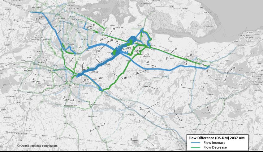
Scheme effect on traffic flows
4.2.9 Error! Reference source not found.to Figure 4.7 show the difference in flow
between the Do Minimum (DM) and Do Something (DS) scenarios for the
opening year (2022) and design year (2037). These figures provide an overall
picture of the wider impacts of the scheme but are unable to accurately identify
changes at the M2J5 itself as the node structure of the network differs between
the DM and DS.
4.2.10 The demand matrices used in the DM and DS scenarios are identical. The only
differences between the two scenarios relate specifically to the M2J5
improvements. The DM network includes all schemes identified in the uncertainty
log as ‘near certain’ or ‘more than likely’, excluding the M2J5 improvements. In
addition to the schemes present in the DM network, the DS network also
includes the M2J5 improvements.
4.2.11 The following observations have been made based on the traffic flow results
presented in Figure 4.2 to Figure 4.7:
• There are greater traffic volumes in both directions on the A249 and the M2
mainline, most notably in the AM peak period;
• The scheme alleviates the high levels of observed congestion on the A249
Southbound between the A2 and M2J5 during the AM peak period. The grade
separation of the junction allows traffic on the A249 to pass through the junction
uninterrupted, leading to an increase in vehicles on the A249 Southbound and a
reduction in vehicles rat running via Oad Street;
• Capacity improvements at the M2J5 results in the reduction of vehicles using
competing north-south routes, especially between Sittingbourne and
Hollingbourne during the AM peak;
• Delay on the M2 Westbound increases between 2022 and 2037 during the AM
peak. Without further transport intervention the M2 struggles to cope with the
increase in demand, resulting in blocking back from the westbound on-slip in
2037;
• During the 2037 AM peak there is a reduction in flow on the southbound on-slip
at the A249 / A2 junction, due to an increase in congestion. The increase in
demand induced by the introduction of the scheme causes delay on the A249
Southbound on-slip, which results in vehicles re-routing to the junction
immediately north of the A249 / A2 junction to access the A249;
Page 15 of 92M2 Junction 5 Improvements
Highways England Statement of Case
• There is a reduction in flow on the M2J5 roundabout circulatory in all forecast
years and time periods. Due to the redesign of the junction vehicles can
continue on the A249 without needing to circulate the roundabout; and
• There is minimal evidence of reassignment in the IP as the junction is less
congested in the DM.
Page 16 of 92M2 Junction 5 Improvements
Highways England Statement of Case
Figure 4.2 Flow Difference Between DS and DM - 2022 AM (Veh/hr)
Page 17 of 92M2 Junction 5 Improvements
Highways England Statement of Case
Figure 4.3 Flow Difference Between DS and DM - 2022 IP (Veh/hr)
Page 18 of 92M2 Junction 5 Improvements
Highways England Statement of Case
Figure 4.4 Flow Difference Between DS and DM - 2022 PM (Veh/hr)
Page 19 of 92M2 Junction 5 Improvements
Highways England Statement of Case
Figure 4.5 Flow Difference Between DS and DM - 2037 AM (Veh/hr)
Page 20 of 92M2 Junction 5 Improvements
Highways England Statement of Case
Figure 4.6 Flow Difference Between DS and DM - 2037 IP (Veh/hr)
Page 21 of 92M2 Junction 5 Improvements
Highways England Statement of Case
Figure 4.7 Flow Difference Between DS and DM - 2037 PM (Veh/hr)
Page 22 of 92M2 Junction 5 Improvements
Highways England Statement of Case
Scheme Effects on Journey Times
4.2.12 Figure 4.8 shows the journey time routes used in the validation of the base year
model. Using these validation routes, Table 4.1 to Table 4.3 show the difference
in journey times between the DM and DS for 2022 and 2037 by time period.
4.2.13 Most journey time routes remain relatively unaffected by the scheme, except the
A249 routes. There is a reduction in journey times on the A249 southbound
across all time periods, owing to the scheme junction configuration which
alleviates queuing on the northern A249 arm of the junction. There are similar
impacts northbound, but not of the same magnitude.
4.2.14 There is an increase in journey times on the M2 in both directions during the AM
and PM peak periods, most notably westbound in the AM peak. The scheme
capacity improvements have increased traffic volumes accessing the M2 at
junction 5. As a result, the increase in demand devoid of traffic improvements on
the M2 has increased delay on the mainline.
4.2.15 However, despite the three-minute increase in journey times on the M2
Westbound in the AM peak, there is a three-minute journey time saving on the
A2 Westbound. The attractiveness of the A249 has increased following the
mitigation measures implemented at M2J5, which has resulted in vehicles re-
routing from the A2 Westbound to the M2 Westbound.
Figure 4.8 Journey Time Routes
Revision P01.3 Page 23 of 92M2 Junction 5 Improvements
Highways England Statement of Case
Table 4.1 Journey time - AM peak
2022 2037
Network Performance Route Name Dir.
DM DS Diff. Diff. (%) DM DS Diff. Diff. (%)
Isle of Sheppey Crossing to NB 00:12:37 00:12:12 00:00:25 -3.3% 00:12:48 00:12:34 00:00:14 -1.8%
A249
M20 Junction 7 SB 00:19:01 00:12:19 00:06:42 -35.2% 00:24:41 00:15:48 00:08:53 -36.0%
M2 Junction 1 to M2 Junction EB 00:22:36 00:22:45 00:00:09 0.7% 00:24:21 00:24:46 00:00:25 1.7%
M2
7 WB 00:27:10 00:27:58 00:00:48 2.9% 00:33:14 00:36:44 00:03:30 10.5%
M20 Junction 4 to M20 EB 00:20:14 00:20:15 00:00:01 0.1% 00:20:41 00:20:44 00:00:03 0.2%
M20
Junction 7 WB 00:21:58 00:22:07 00:00:09 0.7% 00:25:48 00:26:01 00:00:13 0.8%
A2/A231 Junction to M2 EB 00:41:41 00:42:07 00:00:26 1.0% 00:51:03 00:49:16 00:01:47 -3.5%
A2
Junction 7 WB 00:45:22 00:43:14 00:02:08 -4.7% 00:55:12 00:51:41 00:03:31 -6.4%
Hollingbourne to Hollingbourne/A20 Junction NB 00:18:22 00:18:22 00:00:00 0.0% 00:18:24 00:18:23 00:00:01 -0.1%
Sittingbourne to Sittingbourne/A2 Junction SB 00:18:23 00:18:23 00:00:00 0.0% 00:18:22 00:18:23 00:00:01 0.1%
Page 24 of 92M2 Junction 5 Improvements
Highways England Statement of Case
Table 4.2 Journey time - Inter Peak
2022 2037
Network Performance Route Name Dir.
DM DS Diff. Diff. (%) DM DS Diff. Diff. (%)
Isle of Sheppey Crossing to NB 00:12:18 00:11:56 00:00:22 -3.0% 00:12:27 00:12:03 00:00:24 -3.2%
A249
M20 Junction 7 SB 00:12:28 00:12:01 00:00:27 -3.6% 00:12:49 00:12:09 00:00:40 -5.2%
M2 Junction 1 to M2 Junction EB 00:22:00 00:22:00 00:00:00 0.0% 00:23:01 00:23:03 00:00:02 0.1%
M2
7 WB 00:22:32 00:22:32 00:00:00 0.0% 00:24:59 00:25:02 00:00:03 0.2%
M20 Junction 4 to M20 EB 00:19:51 00:19:51 00:00:00 0.0% 00:20:23 00:20:24 00:00:01 0.1%
M20
Junction 7 WB 00:19:37 00:19:37 00:00:00 0.0% 00:20:17 00:20:17 00:00:00 0.0%
A2/A231 Junction to M2 EB 00:39:07 00:39:02 00:00:05 -0.2% 00:42:50 00:42:38 00:00:12 -0.5%
A2
Junction 7 WB 00:38:27 00:38:32 00:00:05 0.2% 00:40:44 00:40:56 00:00:12 0.5%
Hollingbourne to Hollingbourne/A20 Junction NB 00:18:21 00:18:21 00:00:00 0.0% 00:18:22 00:18:22 00:00:00 0.0%
Sittingbourne to Sittingbourne/A2 Junction SB 00:18:21 00:18:21 00:00:00 0.0% 00:18:22 00:18:22 00:00:00 0.0%
Page 25 of 92M2 Junction 5 Improvements
Highways England Statement of Case
Table 4.3 Journey time - PM peak
2022 2037
Network Performance Route Name Dir.
DM DS Diff. Diff. (%) DM DS Diff. Diff. (%)
Isle of Sheppey Crossing to NB 00:13:04 00:12:41 00:00:23 -2.9% 00:13:38 00:12:59 00:00:39 -4.8%
A249
M20 Junction 7 SB 00:13:27 00:12:09 00:01:18 -9.7% 00:16:07 00:12:18 00:03:49 -23.7%
M2 Junction 1 to M2 Junction EB 00:26:51 00:26:58 00:00:07 0.4% 00:32:26 00:33:03 00:00:37 1.9%
M2
7 WB 00:23:08 00:23:10 00:00:02 0.1% 00:27:52 00:28:24 00:00:32 1.9%
M20 Junction 4 to M20 EB 00:23:31 00:23:29 00:00:02 -0.1% 00:26:17 00:26:20 00:00:03 0.2%
M20
Junction 7 WB 00:19:43 00:19:43 00:00:00 0.0% 00:20:03 00:20:03 00:00:00 0.0%
A2/A231 Junction to M2 EB 00:49:25 00:48:31 00:00:54 -1.8% 01:00:22 00:59:37 00:00:45 -1.2%
A2
Junction 7 WB 00:43:50 00:42:59 00:00:51 -1.9% 00:48:17 00:45:07 00:03:10 -6.6%
Hollingbourne to Hollingbourne/A20 Junction NB 00:18:22 00:18:22 00:00:00 0.0% 00:18:22 00:18:22 00:00:00 0.0%
Sittingbourne to Sittingbourne/A2 Junction SB 00:18:22 00:18:22 00:00:00 0.0% 00:18:24 00:18:24 00:00:00 0.0%
Page 26 of 92M2 Junction 5 Improvements
Highways England Statement of Case
4.3 Operational model assessment
4.3.1 The strategic model outlined above has been developed to assess the impact of
the Scheme across the entire wider study area, including how traffic will reroute
due to the changes in the highway network as well as accounting for the levels of
traffic growth forecast. An operational model has also been developed to provide
a more detailed assessment of M2 Junction 5. The base year model has been
validated in line with WebTAG guidance and has been used as a basis to
consider the performance of the Scheme. This operational model draws on the
traffic flow data from the wider strategic model providing a level of consistency
between the models.
Forecast results
4.3.2 Using the wider strategic model forecasts of traffic movements around M2
Junction 5, the impacts have been assessed within the operational model.
4.3.3 Table 4.4 and 4.5 present the key network performance parameters for both the
AM and PM peak respectively for the forecast years 2022 and 2037.
4.3.4 The network performance results show that the Scheme is predicted to provide
improvements in delay at M2J5, in addition to improvements in average journey
times in the AM and PM peak.
4.3.5 The average network speed is predicted to improve from around 40mph in the
DM scenario to 50mph in the DS scenario in both the AM and PM peak hours.
Table 4.4 Network performance results – AM peak hour
2022 2037
Parameters
DM DS Diff. (%) DM DS Diff. (%)
Average Network Journey Time (sec) 347 249 -28% 426 260 -39%
Average Delay time (sec) 153 36 -76% 210 48 -77%
Average Network Speed (mph) 36 50 38% 29 48 64%
Total Delay (hrs) 450 110 -76% 687 167 -76%
Total Latent Delay (seconds) 1564 1280 -18% 488418 2450 -99%
Page 27 of 92M2 Junction 5 Improvements
Highways England Statement of Case
Table 4.5 Network performance results – PM peak hour
2022 2037
Parameters Diff. Diff.
DM DS DM DS
(%) (%)
Average Network Journey Time (sec) 291 246 -16% 326 251 -23%
Average Delay time (sec) 62 35 -44% 136 40 -71%
Average Network Speed (mph) 40 50 24% 38 49 28%
Total Delay (hrs) 196 112 -43% 465 138 -70%
Total Latent Delay (seconds) 1595 1676 5% 6268 2132 -66%
4.3.6 Journey times on the A249 Southbound are predicted to improve by more than 8
minutes in 2022, and by 11 minutes in 2037 during the morning peak hour.
4.3.7 Journey times on the A249 Northbound are predicted to improve by 4 seconds in
2022 and by 2 seconds in 2037 forecast year during the morning peak hour.
4.3.8 In the evening peak hour, the 2022 model predicts about one-minute savings for
the A249 Southbound and 48 seconds for the A249 Northbound direction. The
A249 Southbound journey times are predicted to improve by 4 minutes, whilst
the A249 Northbound journey times are predicted to improve by nearly 2 minutes
in the 2037 evening peak hour.
4.3.9 Journey times through the M2 Eastbound diverge are predicted to increase in the
DM scenario in the 2037 forecast year. This is due to the high volume of traffic
exiting at this junction, which then impacts the M2 Eastbound through traffic.
With the Scheme the roundabout is predicted to operate well within capacity,
however, the M2 Eastbound diverge is predicted to operate over capacity.
4.3.10 As the Scheme does not include improvement at the Eastbound diverge, the M2
Eastbound through journey time is predicted to increase slightly.
4.3.11 The 2037 PM peak hour Do-Something operational model predicts queue at the
M2 Eastbound off-slip diverge.
4.3.12 The network performance results show that the Scheme is predicted to provide
extensive improvements by reducing delays. This is mainly due to the proposed
improvements on the A249 in both directions. Overall network journey times are
predicted to improve in both the AM and PM peaks.
4.4 Economic performance of the Scheme
4.4.1 The economic assessment compares the monetised costs and benefits of the
Scheme (the Do Something or DS) against the alternative without-Scheme
scenario (the Do Minimum or DM). The overall approaches and results are
presented in the Economic Appraisal Package (Appendix 1, H.7). The key
elements and overall result are outlined below.
Page 28 of 92M2 Junction 5 Improvements
Highways England Statement of Case
TUBA economics
4.4.2 User benefits during normal operation over a 60-year period, relating to savings
to travel times, vehicle operating costs and user charges, have been assessed
using the Department for Transport’s (DfT) Transport User Benefit Analysis
(TUBA) programme.
Accidents
4.4.3 The appraisal of accident savings due to the Scheme was undertaken using
COBA-LT software. The COBA-LT assessment provides an analysis of the
impact on accidents of a highway scheme, including a monetised impact for
inclusion in the Benefit to Cost Ratio (BCR) discussed below. Overall the
Scheme is forecast to provide £24.12 million of accident benefits (2010 values
and prices discounted to 2010) over the 60-year appraisal.
Environmental impacts
4.4.4 The impacts of the Scheme on greenhouse gas emissions, local air quality and
noise has been assessed using the traffic flow and speed data taken from the
strategic transport model. This has been undertaken in line with the DfT’s
WebTAG guidance. These results have then been included in the overall
economic assessment of the Scheme.
Reliability and Wider Economic Impacts and Social and Distributional
Impacts
4.4.5 Supplementary assessments have been undertaken to consider journey time
reliability benefits, Wider Economic Impacts, and Social and Distributional
Impacts in line with WebTAG guidance.
Costs
4.4.6 Scheme costs have been supplied and adjusted to 2010 values and prices to be
consistent with the economic benefits forecasts for the Scheme.
Overall economic benefits
4.4.7 Table 4.6 below shows the Initial Benefit to Cost Ratio (Initial BCR), which
includes all the elements described above apart from journey time reliability
benefits and Wider Economic Impacts. On this basis the Present Value of
Benefits (PVB) is estimated at £234.66m, and the Present Value of Costs (PVC)
at £74.83m. This produces a Net Present Value (NPV) of £159.83m and a BCR
of 3.14.
4.4.8 Journey time reliability benefits (£0.31m) and Wider Economic Impacts
(£10.74m) are then added to give an Adjusted BCR. Adding these increases the
PVB to £245.71m. The PVC is unchanged at £74.83m. This gives an adjusted
NPV of £170.88m and an adjusted BCR of 3.28.
Page 29 of 92M2 Junction 5 Improvements
Highways England Statement of Case
Table 4.6 Summary of economic assessment results
Item Core Scenario
Noise -£0.03m
Local Air Quality £0.05m
Greenhouse Gases -£8.02m
Accident Savings (COBA-LT) £24.12m
Economic Efficiency: Travel Time £217.53m
Economic Efficiency: Vehicle Operating Costs £6.16m
Economic Efficiency: Construction and Maintenance -£3.67m
Wider Public Finances (Indirect Taxation Revenues) -£1.48m
Initial Present Value of Benefits (PVB) £234.66m
Broad Transport Budget £74.83m
Present Value of Costs (PVC) £74.83m
Initial Net Present Value (NPV) £159.83m
Initial Benefit to Cost Ratio (BCR) 3.14
Journey Time Reliability £0.31m
Wider Economic Impacts £10.74m
Adjusted Present Value of Benefits (PVB) £245.71m
Adjusted Net Present Value (NPV) £170.88m
Adjusted Benefit to Cost Ratio (BCR) 3.28
Note: 60 year appraisal costs and benefits are expressed in 2010 values and prices
Page 30 of 92You can also read