Experiences with transit oriented development - (TOD)
←
→
Page content transcription
If your browser does not render page correctly, please read the page content below

Denne artikel er publiceret i det elektroniske tidsskrift
 Artikler fra Trafikdage på Aalborg Universitet
 (Proceedings from the Annual Transport Conference
 at Aalborg University)
 ISSN 1603‐9696
 www.trafikdage.dk/artikelarkiv

Light railways and busways as key driver for
sustainable urban development: The Swedish
experiences with transit‐oriented development
(TOD)
Todor Stojanovski, todor.stojanovski@abe.kth.se, Mats Johan Lundström,
mats.lundstrom@abe.kth.se, and Tigran Haas, tigran.haas@abe.kth.se
KTH Royal Institute of Technology, Stockholm, Sweden

Abstract
Sustainable urbanism and good placemaking revolve around creating and maintaining sustainable and
attractive places, by reviving planning and urban design paradigms, by experimenting and innovating and
by building synergies between the old and the new. The expectations for wide accessibility and networking
are very high and the challenge today is to integrate and improve the efficiency and effectiveness of urban
and transport systems. The transports have to fulfil the ongoing demands for enhanced efficiency, comfort,
safety and speed, as well as the environmental factors in the light of global climate change and energy
crisis. One accent in the last 20 years has been on transit‐oriented development (TOD), compact cities and
urbanity‐empowering public transports like light railways or light rail transit (LRT) or bus rapid transit (BRT)
with its busways as key drivers for sustainable neighbourhoods.

TOD in a Swedish (European) perspective is by no means a new idea. Three cases of newer light railway and
busway projects (Stockholm, Gothenburg and Norrkoping) are explored in this article and they are seen
through a historical overview of the TOD experiences in Sweden and around the world. We also investigate
and draw attention to the values of placemaking and sustainable urbanism via the advantages and
disadvantages of the urban and regional public transport systems and TOD principles.

Keywords: transit‐oriented development (TOD), Sweden, light railway (LRT), bus rapid transit (BRT),
sustainable urbanism, placemaking

Sustainable urbanism and good placemaking revolve around creating and maintaining sustainable and
attractive places, by reviving urban planning and design paradigms, by experimenting and innovating, and
by building synergies between the old and the new. The transports play crucial role in the sustainable urban
endeavour and the expectations for wide accessibility are very high today. The challenge is to integrate and
improve the efficiency and effectiveness of the urban and transport systems and the transports have to
fulfil the ongoing demands for enhanced efficiency, comfort, safety and speed, as well as the
environmental factors in the light of global climate change and energy crisis. One accent has been on public
transports and transit‐oriented development (TOD) or compact cities with urbanity‐empowering public

Trafikdage på Aalborg Universitet 2012          ISSN 1603‐9696                                                 1
transports like light railways or light rail transit (LRT) or bus rapid transit (BRT) with its busways as key
drivers for sustainable neighbourhoods. Transit, a shortening from mass transit, is an American catchall for
public transport (Cervero, 1998:15) and TOD can be described as a policy to synchronize urban planning
and development with public transports. Peter Calthorpe, who introduced the catchy coinage in the
beginning of the 1990s, defines TOD as design or development of moderate and high density mixed‐use
urban areas at strategic points along the regional public transport system (Calthorpe, 1993:41‐45).

The European parallel to the American TOD is roughly the compact city. It is advocated by the European
Commission (EC) and has been central in the European sustainable cities debate since the 1990s. The
vibrant and lively compact city and the contained and ecological green city are two principle sustainable
cities. The compact city favours architectural heritage, by respecting rather than imitating the old, greater
diversity by mixed uses, particularly housing in inner city areas, and solving urban problems within existing
boundaries of the city without extending its periphery (EC, 1990:30). The argument is that density and
diversity are more likely to result into people living close to work places and services that are required for
the everyday life (EC, 1990:40). The ambition of the compact city is also to make the private car an option
in cities rather than a necessity (EC, 1990:30) by creating integrated, intermodal transport systems which
fully exploits the potential of public transport (EC, 1997:11‐2). There are numerous experiments of compact
neighbourhoods in the last 20 years throughout Europe with a paramount accent on intermodality and
urbanity. Like in American TOD, LRT and BRT are preferred and widely applied in many European
sustainable neighbourhoods.

But TOD as policy to synchronize urban planning and development with public transports in a Swedish and
European perspective is by no means a new idea. There is wide body of knowledge and heuristics about
public transport systems, cities and their interplay. We focus in this paper on three cities with newer light
railway and busway projects (Stockholm, Gothenbourg and Norrkoping) and they are positioned in a
historical overview of TOD experiences in Sweden or through a prism of the principle public transport cities.

The principle public transport cities
The cities throughout the history have been shaped by transport technologies and the mobility of their
citizens. We made a simplified categorization (Figure 1) to describe and cluster the public transports
infrastructures as technologies which have similar effect on cities. There are three principle public transport
technologies by effect on cities: 1) public transports on streets (buses and trams); 2) completely separated,
either elevated or on the ground (heavy railways or busways); 3) underground (subways); contributed by a
hybrid of the three: 4) public transports partially separated on ground (light railways or busways). The
categories for technologies and infrastructures are unorthodox and open for further discussion. We
abducted the common distinction in transports (light versus heavy), where heavy means always complete
or full separation regardless if it is a bus or rail system, whereas light attribute is for systems that anchor on
partially separated, or are partially on street or partially fully separated.

Figure 1: The public transport technologies through infrastructures (designed with Karl Kottenhoff)
                        On streets in Dedicated lane Partially separated Fully separated on In tunnel or
                        traffic       on streets      on ground            ground or elevated underground
Bus line                X             X               (X)
Light busway                          (X)             X                    (X)
Heavy busway                                          (X)                  X                   (X)
Tramway                 X             X               (X)
Light railway           (X)           (X)             X                    (X)                 (X)
Heavy railway                                                              X                   (X)
Subway                                                                                         X

The categories show the anchor (designated by (X)) and ranges (designated by (X)) of the various public
transport infrastructures and their position as public transport technologies shaping cities. Two principle
technologies tend to concentrate over specialized infrastructures and excel either on urban (public

Trafikdage på Aalborg Universitet 2012               ISSN 1603‐9696                                             2
transports on streets) or regional scale (fully separated on ground or elevated public transports), whereas
the underground public transports excel both on urban and regional scale. The hybrids, public transports
partially separated on ground, also tend to have wide span claiming both domains.

Each principle technology enabled distinctive urban and regional growth pattern and unique placemaking.
The public transport on streets accelerated the urban life and enabled elongation and interweaving of the
cities along the bus lines and tramways. The completely separated public transport orchestrated
discontinuity of urban fabric and regional existence as temporal convergence of distant places: the railways
principled urban dispersal or fragmentation of the city in its region. The public transport underground
strengthened the polycentric agglomeration of the existing cities by adding speed, capacity and
concentration: the subways connected urban nucleuses in a network. There are four principle public
transport cities, analogous to the technologies (Figure 2): 1) the elongated and interwoven city of buses
and trams; 2) the railway city of pearls; 3) the networked city above the underground; and 4) the compact
city along the light railways and busways. The four principle public transport cities are fuzzy models for
TOD, each with its own history and future.

Figure 2: The principal public transport cities

The principle public transport cities in Sweden
Very few people lived in cities in the 18th century. In 1800 Stockholm had 75000 inhabitants, followed by
Gothenburg (Göteborg) with 13000, and Karlskrona and Norrkoping (Norrköping) with 10000. Only 10% of
the Swedish population was urban in 1800 and there were 6 cities that had more than 5000 inhabitants
(SCB, 1969).

From the 1830s the public transports facilitated rapid urbanization in Sweden and played different roles,
experiencing changing reputations, in the urban and regional growth of Stockholm, Gothenburg and
Norrkoping. There is regional growth (Figure 3) in the three cities, but the lines have very different
inclinations. Stockholm grew tenfold, Gothenburg four times, while Norrkoping region doubled its
population. Stockholm, Gothenburg and Norrkoping developed differently. The buses and trams influenced
the growth of the three cities in the 19th and the first half of the 20th century shaping their urban cores.
While Stockholm developed continuously as metropolis with railways and subways merging into a
metropolitan system, Gothenburg and Norrkoping preserved their tramways and began to disperse in their

Trafikdage på Aalborg Universitet 2012            ISSN 1603‐9696                                              3

regions or stagnate as consequence of the high motorization and excellent car accessibility. Stockholm
experienced decrease in urban density, but it increased the urban borders along the powerful public
transport network that gradually extended throughout the 20th century and made the public transports
competitive to the private car. The urban cores of Gothenburg and Norrkoping became literally urban
fragments in a regional road hierarchy crowned by speedy motorways.

From the 1990s the advocacy for compact and urban living influenced or reintroduced urban growth in
Stockholm and Gothenburg. Their city populations slowly recuperate or increase. There are ongoing infill
developments and redevelopments. Gothenburg reached its urban population level from the 1970s in the
2000s. Norrkoping had almost no change in urban population in the last 40 years with very slow regional
growth.

Figure 3: The population growth in Stockholm, Gothenburg and Norrkoping and their public transports

The buses and trams elongate and interweave the cities
The buses and trams as public transports on street elongate and interweave a continuous amoebic city. The
streets with public transports were and often remained as very attractive directions in the city. The
omnibuses, cable cars, horse cars, trams or streetcars, motorbuses or commonly buses, trolleybuses or
trolleys, are modification of a same public transport technology and if we consider capacity and speed they
did not change dramatically. Hindered by the traffic on the streets, they are slow transports, reaching
averagely 10‐20km/h, thus delimiting their line lengths to 10km. The longer lines are usual, but they are not
attractive to the travel time budgets of one hour per day1. Their lack of speed is compensated by a
longitudinal attractiveness, urbanity and wide access to the general public by shortening walking distances.
They add vibrancy on streets, give pleasant urban vistas and create mobile public spaces.

The omnibuses (omnibussar, hästomnibussar) in Sweden were introduced in Stockholm and Gothenburg in
1835 and 1837, while trams or horse cars on rails (hästspårvagnar) rolled in Stockholm and Gothenburg

1
 Yakov Zahavi researched and developed the theory behind the travel time budgets, while Cesare Marchetti popularized with his
article about human mobility invariants.

Trafikdage på Aalborg Universitet 2012               ISSN 1603‐9696                                                        4
from 1877 and 1879. The trams (spårvagnar) preceded the buses (bussar) in Norrkoping and opened
service in 1904 followed by the motorbuses (motorbussar) which came in 1921.

The buses and trams in Stockholm
The omnibuses arrived in Stockholm as inspiration from Paris. There were 6 lines with 15 and 30 minutes
service already in the 1860s. They reached its peak in the 1870s2 and they were continuous and fierce
competition to the trams. The central line in Stockholm was operated by omnibuses and motorbuses even
in the heyday of the trams in the beginning of the 20th century (Holmberg, 1958; 1960:75‐7).

The tramways came in Stockholm3 in the end of the 1870s and they expanded very quickly. Stockholm was
a stage where several tramway and railway companies competed for turf from the 1890s. As a
consequence the city made amoebic extensions northward, eastward, south‐eastward and southward to a
radius to 10km by 1920s shaping the urban core of Stockholm today. But already in the 1930s it was
decided to remove the tramways in the inner city and replace them with buses.

The slow public transport in the inner city of Stockholm relies almost completely on buses from the 1960s.
The buses are important part of the urban life today4 and it is it is almost impossible to think about
Stockholm without its blue buses that perpetually traverse the main streets and the sightseeing reds. They
give acceleration to walking, comfort and astonishing urban outlooks, vibrancy, quick refuge from the cold
and they often support the initial and final communication to the speedy metropolitan system, the
tunnelbana and other railway links.

The bus lines and tramways made attractive urban corridors (buses on Drottningatan or trams on
Hornsgatan, Sveavägen, Kungsgatan, Odengatan are some examples) and interwove the streets, squares,
churches and neighbourhoods along. They shaped the urban core of Stockholm in what is today.

The trams in Gothenburg and Norrkoping
Gothenburg and Norrkoping are only two cities in Sweden that kept their tramways throughout the history.
But the cities had very different growth patterns. Norrkoping is one of the oldest industrial centres in
Sweden that grew very slowly, whereas Gothenburg had accelerated growth, then quick dispersal and
urban decline.

Gothenburg experienced rapid industrialization in the second half of the 19th century and the city spread
out of the spiky city wall already in the 1860s. The trams arrived in Gothenburg in 1879 and facilitated the
radial expansion outward, supported by boats and ferries crossing the river (Göta älv) on the north. In the
1920s there was an extensive network of radial and orbital tramways within a radius of 5km and the city
grew rapidly and compactly along. As in Stockholm, the bus lines and tramways made attractive urban
corridors (Västra and Östra Hamngatan for example) and connected the main squares and neighbourhoods
along. But Gothenburg did not develop metropolitan system as Stockholm (see Figure 3). There were no
suburban railways and the two proposals for a subway (underbana from underground railway) in 1934 and
1967 remained on paper. Under the pressure of accelerated motorization the city experienced urban

2
  In the middle of the 1870s the most central omnibus line carried consecutively over 500000 passengers per year. The central line
was successful even in the heyday of trams transporting over 1 million passengers per year in the end of the 19th century.
3
  The first decision to lay 3 tramways in Stockholm came in 1870, but the company that got the concession bankrupted. Eventually,
a new company was established that started a service in 1877. The revenues on the first day showed that more than 10000
passengers took the trams. In the beginning of the 20th century there were 9 tram lines operated by two companies, 7 in the north
and 2 in the south of the city. The two companies were bought and incorporated in the public company in the 1910s that has been
responsible for the public transport in Stockholm until today. In the 1920s there were 12 urban and 9 suburban tramway or light
railway lines, and 3 urban bus lines.
4
  In 2009 there were almost 300000 daily journeys by bus within the inner city. The urban buses, especially the blue buses have
most prominent status, but buses exist with various interiors and purposes. Stockholm has been a laboratory for buses for almost
two centuries. There are urban and suburban buses coloured in red and blue. The interiors of the urban red and blue buses are
more carefully designed to look like mobile public spaces, with lower floors and less seats, whereas the suburban have interiors
enhanced for higher speeds with more seats.

Trafikdage på Aalborg Universitet 2012                 ISSN 1603‐9696                                                           5
decline and decentralization with very strong regional growth beyond the attractive radiuses of the
tramways. The city extends in a region with over 80km radius today (Hagson and Mossfeldt, 2008).

Norrkoping is one of the oldest Swedish industrial centres. It is located on a river that was regulated with
series a dams to power manufactures and factories since the 17th century. The city had a dense urban core
already in the 18th, but it developed much slower than the other industrial centres. It elongated
northeastwardly and southeastwardly along two tram lines which opened from 1902 and the buses in the
1920s completed a radial public transport network extending roughly 5km. Norrkoping developed
compactly within that radius until today and the tramways accent the most important directions in the city
with denser developments and enrich the urbanity and charm of Drottningatan, the most attractive street
in the city.

The railways principle the city’s suburbs
In the 19th century the railways were exciting and revolutionary technology of speed, infrastructures, clocks
and timetables, wagons and compartments, classes and tickets. They were hated and fenced for bringing
the industrial landscape and overcrowding in the city, but they were also esteemed, inciting inspiration,
fantasy and adventure. The railways had higher speeds and own infrastructure, and unlike the stops on the
streets, the stations were nodes, pearls on an impenetrable string. They were placed on distances that
prevented overlapping buffers, gave total control over the accessibility. The railway city of pearls was
motivated by monopolistic entrepreneurship that targeted twofold gains. The developers bought almost
worthless land on the periphery, laid railways and designed suburbs. The buildings were sold or leased,
while the fares were bringing continuous and lucrative profits.

The railways are speedy transports which make a hierarchy of access and desirability and link urban pearls
scattered over wide distances. The city of pearls can theoretically extend over 100km, far beyond the
access of the car. The city of pearls exists in reality as metropolis, a mother city, usually networked by
subways, buses and trams, which subordinates the pearls and other urban fragments scattered in the
region. Stockholm is the only city in Sweden which developed as metropolis or city of pearls with urban
fragments connected by heavy rail or bus links and the satellite pattern was visible already in the 1930s.
The urban fragments beyond the suburban railway network were connected by direct or express buses
even then.

Edelsvärd’s ideal railway city
The railways as exciting and revolutionary technology inspired many. Adolf Wilhelm Edelsvärd was an
architect which made a model of an ideal city with a railway station in its core which it is probably one of
the oldest TODs.

Figure 4: Adolf Wilhelm Edelsvärd’s ideal city/urban plan from 1859 in Tidskrift för Byggnadskonst och Ingenjörsvetenskap

Trafikdage på Aalborg Universitet 2012                ISSN 1603‐9696                                                        6

Edelsvärd’s city (Figure 4) is functionally divided. It has an urban core of public buildings (hatched blocks)
with a picturesque boulevard as an axis. The sequence of public spaces starts with a square in front of the
railway station, parks on both sides, square with church surrounded by court and other public buildings and
ends with fair and amusement park (tivoli). The industry (W) is located along the railway and the houses on
the wings (hollow blocks). In the core of the housing quarter there is a square (W). Each housing block is
around 400 feet and divided by an alley. There are 12 houses in each block and the building coverage of the
plots is 30‐40%, while the rest is used for gardening (Edelsvärd, 1859), reflecting the picturesque and
naturalism of the industrialization period.

The railway suburbs in Stockholm
The garden suburb was the realistic counterpart to Edelsvärd’s ideal railway city. The suburbanization of
Stockholm started in the 1890s. The tramway and railway companies who competed for turf in the city also
bought land in the countryside and laid suburban railways to profit on increasing land values (see
Svalhammer, 2008:57‐8). They even developed garden suburbs which achieved copious fame as cities of
villas (villastäder) in Sweden. The entrepreneurs quickly understood that railways dramatically increase
land values and that the garden suburbs are very attractive and the battle for turf in the city expanded in
the countryside.

Figure 5: Collage of photographs from Djursholm, the city of villas on the north of Stockholm, and Djursholmsbana or
                                                                  th
Roslagsbana today, the suburban railway, from the end of the 19 century and today (source for the historical photographs:
Stockholms Spårvägsmuseum/Stockholm Transport Museum)

There were two entrepreneurship models in suburbanization of Stockholm. Sometimes the development
and railway companies cooperated, whereas sometimes one company laid both railways and developed
land. Djursholmsbana (or Roslagsbana today) is a railway which connected Djursholm, one of the first

Trafikdage på Aalborg Universitet 2012               ISSN 1603‐9696                                                         7
garden suburbs with a terminus then on the north of the city. One company was running the trains and
extended the railway network northward, while another company planned and developed suburbs along.
Other companies had funds to invest both in the development of railways and land. Knut Agathon
Wallenberg was a banker and politician who both financed the Sältsjöbana, suburban railway which
terminated in Slussen, and developed a string of suburbs eastward (Svalhammer, 2008:43).

The ABC suburb and city
The ABC principle was a Swedish response to the modernist functional city5 inspired also by the advocacy
for polycentric metropolis and neighbourhood or community focus in Lewis Mumford’s Culture of cities
(Nyström and Lundström, 2004). The metropolis structure described by Mumford (1934:486‐93) existed in
Stockholm as an array of radial railways with suburban strings of pearls already in the 1930s and Sven
Markelius, the planning director in the city of Stockholm, recognized and established it as a model for
future development. The ABC principle was actualized either as suburb or a satellite city, a cluster of
suburbs. The suburb as a pearl (Figure 6) has urban sectors that should represent a Stockholm in a
miniature, whereas the satellite city6 literally suburbanizes the suburbs by a hierarchy of centres (Figure 6).

Figure 6: Suburb as pearl from Future Stockholm (Framtida Stockholm) in 1945 on the left (the numbers represent the floor area
ratios of the housing districts) and the satellite city by Sven Markelius on the right from Byggmästaren 1945 (C main centre, LC
local centre, H multifamily housing, R row housing, V villas, I industries)

Stockholm’s metropolis model one of the most successful TODs. Despite the high motorization in the
Stockholm region the share of public transport is very high, especially during rush hours. The centres in the
ABC suburbs or cities act as public transport nodes, whereas the diversity and density of the ABC city
attracts passengers and balances the public transport demand between the suburban pearls and the urban
nucleuses. The urban or suburban centres are interconnected with the speedy and frequent tunnelbana or

5
  The ABC city stands for arbete (working), bostad (housing) and centrum (centre) and is much inspired and critical to Le Corbusier’s
urbanism and the functional city in CIAM’s Athens Charter.
6
  Sven Markelius in two articles (Markelius, 1945; 1956) argued for larger suburbs with at least 50000 inhabitants with various
typologies to support the housing preferences. The satellite city of pearls was a response to that problem. Markelius planning office
produced both the visionary overture Future Stockholm (Framtida Stockholm) and the unbinding Generalplan för Stockholm 1952,
which shaped the ABC principle and what is Stockholm today.

Trafikdage på Aalborg Universitet 2012                  ISSN 1603‐9696                                                             8

other rail or bus links with high capacity. In a same time there is public transport hierarchy of slower and
faster, feeder and trunk lines which bring passengers from the less dense fringes of the ABC suburbs or
cities into the centres.

Figure 7: Collage of photographs from Vällingby, the first ABC city, from the 1950s and today. The photographs of the centre (C
element in ABC) are on the left and on the right are the photographs from the diverse residential areas (A element in ABC)
surrounding the centre (source for the historical photographs: Stockholms Spårvägsmuseum/Stockholm Transport Museum)

Networked inner Stockholm
The networked city in reality is the urban part, the heart of the metropolis hierarchy. The subways connect
suburban railways or expand as railways outward. Terribly expensive, they preserve the city above,
protecting the traditional urban fabric and historical heritage. In a same time they affect the vibrancy of
urban life by networking the places above. They rival or outperform any surface transport in congested
urban cores and they do not cause visual impacts as the elevated systems. They act much like the diagonals
of Rome or the baroque European capitals, just invisible to the city above.

Stockholm’s inner city and its tunnelbana
In 1913 Knut Agathon Wallenberg opened a debate about a subway that will network the radial suburban
railways and tramways. The subway was branded tunnelbana (railway in a tunnel) and the first tunnel
opened in 1933 under the south island between Slussen and Skanstull. In the 1930s the politics changed
favouring busses and subway over trams and the entire system adopted the catchy brand tunnelbana (see
Svalhammer, 2008:78‐92). The central station opened in 1957 connecting the radial tramways and railways
into a powerful system. More than one million passengers aboard the tunnelbana daily and the
Stockholm’s underground is a city itself which keeps the city above alive and vibrant. The urban buses give
attractiveness to the main streets and make slow links between the squares and monuments, the
tunnelbana connects them city very quickly and comfortably.

Trafikdage på Aalborg Universitet 2012                 ISSN 1603‐9696                                                             9

Compact city along light railways and busways as sustainable European
city
The light railways emerged as a compromise between tramways and railways in the 19th century as
systems partially on the street, partially fully separated. Many, especially American cities developed along
light railways or interurbans in the end of the 19th and the beginning of the 20th century. Los Angeles
developed the most extensive railway network in the world which in its peak, in the 1920s, had over
1600km of interurban railways connected with over 320km of tramways.

The advocacy behind the compact city in the last 20 years in Europe revives this historical public transport
city and revolves around partially separated public transport infrastructures like light railways and busways.
Stockholm and Gothenburg have started experiments with sustainable neighbourhoods having light
railways and busways as structuring urban elements, whereas Norrkoping extended its tramways in order
to renew, diversify and intensify the neighbourhoods along.

Hammarby Sjöstad and the other developments along the Tvärbana in
Stockholm

Figure 8: Tvärbana and new urban developments

Hammarby sjöstad (translated as waterfront city) evolved in a sustainable city model in the 1990s. It fuses
the traditional and ABC city in a compact unity along ideally sized light railway corridor. It has offices,
shopping and even industry, but these varied functions are mainly put in different parts, whereas the
buildings along the corridor have vertical mix of function as in the historical core. The politicians wanted a
true urban feel (stadsmässighet in Swedish) along the esplanade, as in the inner city. It is located south

Trafikdage på Aalborg Universitet 2012          ISSN 1603‐9696                                               10
from the inner city district Södermalm and separated by a lake. The northern waterfront developed a
pattern of quasi enclosed urban blocks in the early 1990s maximizing the lake views, which replicated on
the southern waterfront.

The winding green esplanade of the Tvärbana, the orbital light railway, is the backbone of the
neighborhood. This 37 meter wide urban corridor collects pedestrians, bikers, trams, buses and cars in
clearly defined linear stripes. The median tramway is partially separated from car traffic and fenced by
longitudinal park. The bicycle lane is placed between the car lane and a strip of on street parking. The
sidewalks are the last stripe having direct contact with the commercial frontage of the buildings.

Figure 9: The waterfront and the tramway bridge, the pedestrian zone parallel to the main esplanade, the main esplanade and
the Luma station on a square in Hammarby sjöstad

The city planning office wanted less private cars and high share of public transport and had heavy
restrictions on parking places. The sustainable mobility measures were subverted by the development
companies who had problems selling the apartments. Some apartments were sold in a package with a new
car.

The neighbourhood also attracted younger affluent families with high demand for mobility and wide
accessibility and the slower light railways and the extra transfer seemed like a worse alternative then the
car. The neighbourhood was not directly connected to the metro or railway lines, but the people needed to
make transfer through an old greyish industrial area on the west which felt like leaving the city. To solve
this problem the newest debate are about extension of the metro in Hammarby Sjöstad which will put the
neighbourhood on the regional system map.

There is ongoing extension of the Tvärbana northwards towards Sundbyberg and Solna with parallel infill
developments and redevelopments in Sundbyberg and Ulvsunda (Figure 10).

Trafikdage på Aalborg Universitet 2012               ISSN 1603‐9696                                                       11
Figure 10: Ongoing urban developments in Sundbyberg on the right and in Ulvsunda on the left

Norrkoping’s tramway extension in Hageby
Norrkoping is one of only two Swedish cities, with Gothenburg, that have kept its tram system over the
years. There are two tram and four urban bus lines in the city and the trams handle almost half of all the
passengers that use the urban public transport. The city opened a 4 km extension of the tramway to the
southern suburbs of Ljura, Hageby and Navestad in 2011.

The extension should make these suburbs more attractive and sustainable and inspire new urban infill
projects. The tram extension connects Ljura, a housing area from the 1950s, Hageby Centrum, a 1960s
shopping centre and terminates in Navestad, a housing area from the 1960s. Navestad has two housing
complexes called Golden Ring and Silver Ring that were upgraded in the 1990s. To diversify Navestad, there
are plans for more retail, housing and public spaces. The tramway extension will have 10 stops are laid on
grass, which reduces noise. The simultaneous development along the tramway extension was the
renovation of Hageby Centrum. Some new developments are finished and some ongoing (Figure 11).

Trafikdage på Aalborg Universitet 2012               ISSN 1603‐9696                                          12
Figure 11: Urban development along Norrkoping’s tramway extension

Figure 12: The newly developed Hageby centre (Mirum Galeria from 2012) up and down on the left, new developments up on
right and a new area assigned for development in the fall 2012 down on right

Trafikdage på Aalborg Universitet 2012             ISSN 1603‐9696                                                        13
Gothenburg’s busways in Norra Älvstranden
Gothenburg and its region have been the industrial centre and largest port in Sweden since the mid 1900s
when Götaverken, Lindholmen and Eriksberg, three of the world’s biggest shipyards opened on the north
shore of Götälv (the wide river that separated the city from the industrial zone). The manufacturing power
further strengthened when Volvo formed on the end of the 1920s. But since the 1970s, Gothenburg
suffered from deindustrialization that heavily hit the northern industrial waterfront. The industrial area
gradually emptied and the city assigned the northern waterfront (Norra Älvstranden), between the Götälv
Bridge in the East and Älvsborgs Bridge in the west, for development. Large portion of the land is owned by
the city and the renewal started in the 1990s with quite heterogeneous and fragmented developments.
Eriksberg, an early development, much like the northern waterfront opposite of Hammarby Sjöstad displays
a pattern of quasi enclosed urban blocks opening prospects on Götaälv, still closing up towards the streets
to achieve an urban feeling. The more recent developments show less urban attitude, using more building
typologies associated with the modernist era, but still focusing on maximizing water views.

Figure 13: Urban development along Gothenburg’s busway
Göteborg kept and carefully developed its tramway system in the city limits from 1879, but there was no
agreement of a tram extension along the waterfront. Instead, the city and the public transport authority
decided for a system of busways adopting the motto ‘think railways, run buses’, which also influenced the
emergence of blue buses in Stockholm. The busways in Gothenburg however on some parts have been
developed on a grand manner and served by double articulated buses. Lindholmsallén (Lindholm’s
esplanade) is extremely wide (almost 90 meters), including separate bus lanes in the middle, a wide
longitudinal park with double tree lines, double car lanes, another green stripe, single tree line, two‐way
bicycle lane and a separate sidewalk. The urban development is slow, but ongoing. It is located mainly on
the waterfront. The dense development around public transport nodes is yet to come in this part of the
Norra Älvstranden. The esplanade today feels very open and empty.

Trafikdage på Aalborg Universitet 2012            ISSN 1603‐9696                                          14
The waterfront is also served by a Älvsnabben (River quick). It is a popular ferry line within the public
transport system, connecting five stops on the northern and two on the southern (city centre). Two
departures per hour in rush‐hours is not very much, but it is about to increase in the near future. The
Älvsnabbare (‘river Quicker’) shuttle is, as its name suggests, a quicker shuttle line connecting Lindholmen
on the north shore to Rosenlund on the southern shore – each sixth minutes in rush‐hours. Since spring
2011, travelling with Älvsnabbare is free of charge. Similar ferry line free of charge exists in Hammarby
Sjöstad, which was introduced instead of a bridge between the southern and northern waterfront.

Figure 14: New and ongoing developments along the busway on the left and developments around Lindholmen station on the
right

Light railways and busways as key drivers for sustainable urban
development
Light railways and busways as drivers for urban development
The rapid urbanization was essential in integration of the public transports in the cities in the 19th century.
Cervero (1998:95) argues that public transport redistributes rather than produces growth and the public
transport cities were product of urban concentration around train stations and bus or tram lines. The
urbanization and population growth are prerequisites for urban and regional development, whereas the
public transport stops and lines are one of many urban attractors.

The urbanization and population growth have different patterns. Stockholm is a capital, Gothenburg a large
city and they grow much faster than smaller cities like Norrkoping. But there are new developments, infill
developments or redevelopments, along the new light railways and busways in all the three cities. We can
also see urban development regardless if it is a light railway or busway. The busways in Gothenburg as
partially separated public transport systems add value and trigger developments along as the light railways
in Stockholm and Norrkoping.

Trafikdage på Aalborg Universitet 2012             ISSN 1603‐9696                                                        15
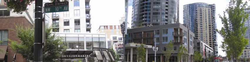
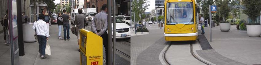
Compact city and TOD
Choay argues that the planning includes rules and models. The rules are procedures for conceiving and
generating space and models are prototypes, a model space or a model of space (Choay, 1997). When we
talk compact neighbourhoods or TODs, seems that the models prevail. We see a wide replication of a
similar urban model of sustainable neighbourhood not only in Gothenburg and Stockholm, but in cities in
Germany, Holland, France and Great Britain. It is a model of dense and diverse urban environment along an
intermodal boulevard as main axis.

In Europe there is a strong tradition and tendency to think in finished models which end in multiple
replications. Sometimes these neighbourhoods are very difficult to change when they are completed. Even
Edelsvärd in his model (Figure 4) leaves empty blocks to be used in the future. The question is do we have
to think in models and replicate them when sustainability escapes blueprints?

Urbanity and intermodality advocacy
Every age imprints itself on the cities. The public transports dominated the 19th century and the beginning
of the 20th and the private car the 20th which reflected on the planning paradigms and tendencies, urban
models and regulations. Mixing as urbanity or intermodality of public and private transports prevails in the
sustainability and cities debates today.

The urbanity is widely highlighted and pursued today both by the compact city and TOD models. The urban
advocacy seems to work in Sweden lately and we can see recuperation and population growth in the larger
Swedish cities like Stockholm and Gothenburg. It however evades the smaller cities which have stagnating
urban population, but experience population growth in their regions. Without urban growth and
development it is difficult to integrate the public transport systems into the cities. Therefore there is a need
for a louder advocacy for urban living and public transports especially in the smaller cities, which are
sprawled as the larger ones, but almost completely dependent on the private car.

The intermodality is also widely advocated, especially among planners and the light public transports seem
to dominate that stage. But LRT and BRT with their light railways and busways are disadvantaged compared
to the fully separated systems. They are too slow to compete with the private car on regional scale. There
must be incredibly strong policies restricting car access and urban containment to make them competitive.
There is ongoing project about the tunnelbana in Stockholm at KTH, Royal Institute of Technology, and the
preliminary results from the traffic models and simulations show that if the tramways or light railway
remained instead of the tunnelbana, the number of daily passengers would decrease between 50% (within
inner city), 70% (to the inner city) and 75% (through the city from north to south). The results are from the
lectures and seminars held by Maria Börjesson and Daniel Jonsson.

Placemaking as an alternative to models
Placemaking is about communities and processes, not about completed models. It is about the human
scale, citizen perspective or view inside of cities in urbanism. Jan Gehl’s ‘in between buildings’ describes
lucidly the prospect within. It started as a loud critique of modernism, the architect’s perspective from the
top and its city grandiose in the end of the 1950s. Willian Whyte and Jane Jacobs wrote the The exploding
metropolis or The death and life of great American cities and the view inside was entangled in Gordon
Cullen’s Concise townscape and Kevin Lynch’s wayfinding and imageability. The argument us that ‘the city
is for humans, not for race of giants playing a new kind of chess’ (Jacobs, 1958:158) and places, districts or
neighbourhoods must be developed within neighbourhoods and with human prospect. The development of
Pearl District in Portland, one of the most famous American TODs, is an example of placemaking through
action plans, proactive planning and community involvement, instead of finished or defined models. By
living, planning and designing together the community enjoys its urbanity and diversity today. In this
ongoing urban process the neighbourhood and public transport entangled together and the Portland
Streetcar became a driver for urban development. Namely in 10 years there has been $3.5 billion
investment along the line. Without placemaking and gradual integration of the public transports in the city,

Trafikdage på Aalborg Universitet 2012         ISSN 1603‐9696                                                16
urbanity can evade TOD and the tramways and light railways will not necessary bring vibrancy and
liveability. In South Waterfront, a new development in Portland, we can see exciting, but finished new
architecture, integration of urban design and location of tramway stops, but without real feeling of a place
that exists in Pearl District.

Figure 15: The vibrant urban life and a tram stop in the Pearl District and newly developed South Waterfront and the Portland
Streetcars terminus
Secondly and very important, Portland Streetcars are urban public transport system and cannot compete
regionally with the cars. That is why there are so many cars in the Pearl District and the share of public
transport is low. The Portland Streetcars are only a Downtown alternative when the people have regional
existence. It is not only important to make places, but also to network these places in the region with
competitive public transports.

Placemaking and networking places
We show in this paper that there is a long history and tradition of integration of public transport in urban
and regional planning and some old models and operators worked fine. The two operators are basically
placemaking and networking places, or pursuing liveable and sustainable places in continuous process of
change and adaptation, and superposing metropolitan systems that will interconnect these places and
make regional hierarchy. Citizens today have regional existence which sometimes extends over 80km.
Stockholm is an example of where the public transports make regional hierarchy with variety of
technologies and modes. It is not always necessary to have one choice, one model and one system, which
can be replicated. The hybrid public transport systems like light railways or busways with wide
infrastructural coverage have to be compared with combinations of innovative, old or new public transport
systems that excel in urbanity and mobility, on urban or regional perspective.

The synchronization of public transports and cities implies two approaches which are not exclusive. The
first is basically the compact city which revolves around policies of containment and preservation of the

Trafikdage på Aalborg Universitet 2012                ISSN 1603‐9696                                                            17
urban fringes as green wedges or agricultural land. In the smaller cities the LRT and BRT systems can act as
mobility systems if the regional accessibility is somehow restricted. It is very challenging prospect, since
many European and American cities developed extensive road hierarchies along the E‐motorways or the
Interstate Highway System which enables excellent car access almost anywhere in the regions. The second
solution is to enact a public mobility hierarchy even in the smaller cities, a metropolitan system with wide
regional accessibility brought by attractive and speedy public transport infrastructures like heavy railways
or busways and urban mobility by slower, not less attractive bus lines and tramways or light railways or
busways. It is again a challenge to superpose an expensive public network over the extensive road
hierarchies.

In the end for gradual and continuous placemaking there is a need to consider the disadvantages and
desirability of the different public transport infrastructure on the urban scale. The effect of the different
public transports and infrastructures on cities is often forgotten. Various public transport infrastructures
have different attractiveness and permeability around stations and along lines. There are desirability cores
which are important urban catalysers, inducers and drivers for urban development.

References
Calthorpe, Peter. (1993) The next American metropolis. Princeton Architectural Press: Princeton.
Cervero, Robert. (1998) The transit metropolis: a global inquiry. Island Press: Washington, DC.
Choay, Françoise. (1997) The rule and the model: on the theory of architecture and urbanism. The MIT
Press: Cambridge.
Edelsvärd, Adolf Wilhelm. (1859) ‘Plan och byggnadssätt för landortsstäder och förstäder’, Tidskrift för
Byggnadskonst och Ingenjörsvetenskap, No. 5, 65‐9.
European Commission (EC). (1990) Green paper on the urban environment.
European Commission (EC). (1997) Towards an urban agenda in the European Union.
Hagson, Anders, and Mossfeldt, Lars. (2008) Analys av tillgänglighet, trafikarbete och färdmedelsval som
funktion av väginvesteringar. Chalmers University of Technology: Gothenbourg.
Holmberg, Sten. (1958) Om bussrörelsen i Stockholm med omnejd. Aktiebolaget Stockholms Spårvägar:
Stockholm.
Holmberg, Sten. (1960) Spårvägen i Stockholm : en minnesbok. Spårvägsmuseet: Stockholm.
Jacobs, Jane. (1958) Downtown is for people. In William H. Whyte, Jane Jacobs, Francis Bello, Seymour
Freedgood and Daniel Seligman. The exploding metropolis, Doubleday & Compani, Inc: Garden City, New
York.
Markelius, Sven. (1945) ‘Stadsplanefrågor i Stockholm’, Byggmästaren 1945, 343‐59.
Markelius, Sven. (1956) ‘Stockholms struktur: synpunkter på ett storstadsproblem’, Byggmästaren 1956,
49‐76.
Mumford, Lewis. (1938) The culture of cities. Harcourt, Brace and Company: New York.
Nyström, Louise and Lundstörm, Mats Johan. (2006) ‘The life and death and life of great neighbourhood
centres’, Built Environment, Vol. 32, No. 1, 32‐52
Svalhammer, Stig. (2008) I väntan på tunnelbanan: kollektivtrafikutbyggnad och bebyggelseexploatering i
Stockholm. Stockholmia förlag: Stockholm.

Trafikdage på Aalborg Universitet 2012         ISSN 1603‐9696                                              18
You can also read