LANDSCAPE ECOLOGICAL ASSESSMENT OF POTENTIAL ECOTOURISM IN MALAYSIA
←
→
Page content transcription
If your browser does not render page correctly, please read the page content below

International Journal of Civil Engineering and Technology (IJCIET)
Volume 9, Issue 10, October 2018, pp. 969–979, Article ID: IJCIET_09_10_098
Available online at http://iaeme.com/Home/issue/IJCIET?Volume=9&Issue=10
ISSN Print: 0976-6308 and ISSN Online: 0976-6316

© IAEME Publication Scopus Indexed

 LANDSCAPE ECOLOGICAL ASSESSMENT OF
 POTENTIAL ECOTOURISM IN MALAYSIA
 Amal Najihah Muhamad Nor*, Rabiatul Adawiyah Isnorm, Muhamad Azahar Abas,
 Nur Hanisah Abdul Malek, Nor Hizami Hassin, Hasifah Abdul Aziz, and Sharifah
 Aisyah Syed Omar
 Faculty of Earth Science, University Malaysia Kelantan, Malaysia

 Nur Hairunnisa Rafaai
 Institute of Environment and Development, University Kebangsaan Malaysia, Malaysia
 *Corresponding Author

 ABSTRACT
 Globally, tourism industry growing rapidly and ecotourism has been a focus in
 the developing countries due to high demand. However, a conflict occur when the
 tourisms resource was capitalize to earn high foreign exchange without
 compromising sustainability of those resources. This study aims to identify the
 potential of ecotourism activity in three study areas (Gua Madu, Ketitir Lake, Jedip
 Village) in Gua Musang, Kelantan, Malaysia for future sustainable ecotourism site
 planning. The integrated approach of landscape ecology and community-based
 management was applied in this study by using remote sense data of 2012,
 Geographical Information System (GIS) and landscape metric. This study found that
 Gua Madu is the most potential ecotourism sites with low patch number, high
 landscape patch index, high patch density and favourable ecotourism activity. This
 study helps ecotourism development towards reducing the overexploit of resources
 and secure ecotourism sustainability in future.
 Keywords: Spatial structure and pattern, Ecotourism, Community-based
 management.
 Cite this Article: Amal Najihah Muhamad Nor, Rabiatul Adawiyah Isnorm, Muhamad
 Azahar Abas, Nur Hanisah Abdul Malek, Nor Hizami Hassin, Hasifah Abdul Aziz, Sharifah
 Aisyah Syed Omar and Nur Hairunnisa Rafaai, Landscape Ecological Assessment of
 Potential Ecotourism in Malaysia, International Journal of Civil Engineering and
 Technology, 9(10), 2018, pp. 969–979.
 http://iaeme.com/Home/issue/IJCIET?Volume=9&Issue=10

 http://iaeme.com/Home/journal/IJCIET 969 editor@iaeme.com

Landscape Ecological Assessment of Potential Ecotourism in Malaysia

1. INTRODUCTION
A mass tourism has grown rapidly to become one of the world’s foremost economic and
social phenomena compared to ecological or environmental based tourism [1]. The World
Tourism Organization estimates that international tourist arrivals in 2022 will reach 1.6
billion worldwide and tourism recipients will exceed more than US$2 trillion [2]. Tourism
industry growing rapidly due to high demand that indirectly influence the developing
countries such as Asia, Africa, Oceania and Latin America. These country currently focus on
ecotourism by using their nature resource attractions. Ecotourism can be best defined as a
nature-based tourism that involves education, interpretation of the natural environment and is
managed to be ecologically sustainable [3]. This explained that the ‘natural environment’
including cultural components and ‘ecologically sustainable’ involved in assessing the
potential of sustainable ecotourism as an appropriate return to the local community and long-
term conservation of the resource [4].
 However, most of local community and ecotourisms’ stakeholders in Malaysia do not
understand the potential of sustainable eco-tourism that can give benefit to them in present
and for future generation. This is due to the lack of awareness among them about concerning
the nature especially land use impact on nature-based tourism. These can be seen when less
assessment has been done on the potential of ecotourism among them and lack of motivation
to develop their area towards the upgrade facilities, transportation and infrastructure
development. Furthermore, lack of knowledge on landscape level assessment has caused
incomprehensible-community based management in order to explore the sustainable
ecotourism potential where most of the natural landscape gets transformed into leisure area
[5]. This situation can cause the permanent ecological pressure increasing directly due to the
behaviour of the holiday makers produce rubbish, sewage, exhaust fumes, trampled on and
remover of plants and animal, and noise. Lack of information on land use and local
community activity will give impact to ecotourism with the improper implementation of
sustainable planning and management [6]. All this notably claim for lack of quantitative data
information to measure the reliability and validity of the information on land use and
community activity for assessing the potential of sustainable ecotourism in Malaysia.
 Therefore, the identification of potential of ecotourism in Gua Musang is still limited.
This made the identification of potential of ecotourism becomes the issue of ecological
landscape. Thus, decision support tools are needed for sustainable tourism that can reconcile
the natural and social environment with the sustainable economic and development. With
regard to the overall research approach, a case study in Gua Musang was gaining prominence
in the identification of potential of ecotourism using landscape ecology approach. To some
extent, it could be predicted that some gaps between theory and practice of ecotourism would
be improved by promoting its sustainability based on ecotourism products' impact the local
community. As a whole, using a landscape ecology approach to achieve ecotourism toward
sustainable already explored as a broader conservation strategy. Thus, promoting the
sustainable ecotourism awareness and understanding the potential of sustainable ecotourism
is important to improve the sustainable land management to the community-based nature
development.
 Therefore, this study quantified the landscape structure pattern of land use in Gua
Musang, Kelantan for sustainable ecotourism by using a landscape ecology approach towards
the quality of life of the local community. Thus, its provide the valuable data and information
for management and planning for assessing the ecotourism potential sites as one of the thrust
areas that have been actively engaged. Besides, the data from this study are important for

 http://iaeme.com/Home/journal/IJCIET 970 editor@iaeme.com
Amal Najihah Muhamad Nor, Rabiatul Adawiyah Isnorm, Muhamad Azahar Abas, Nur Hanisah
 Abdul Malek, Nor Hizami Hassin, Hasifah Abdul Aziz, Sharifah Aisyah Syed Omar and Nur
 Hairunnisa Rafaai

conservation and monitoring of the potentially sustainable ecotourism in order to maintain the
healthy ecosystem and quality well-being of local communities.

2. METHODOLOGY
2.1. Study Area
Based on the potential of Gua Musang to be developed as a sustainable ecotourism
destination, three study areas are selected for sustainable ecotourism assessment which is Gua
Madu, Ketitir Lake, Jedip Village, Pos Brooke, Lojing, Gua Musang (Fig 1).

 Figure 1 Ecotourism area of Gua Musang

2.2. Data Collection and Processing
In this study, the data analysing of landscape structure was conducted by using land use map
of Gua Musang for 2010. The class of land use in Gua Musang are reclassified by Anderson
[7] into arable land, permanent crops and other any land not arable or under permanent crops.
Then, several data of local overlaid on the population data such as the distribution of local
communities, local activity, land use class and the ecotourism activity done by the local
community in the study areas in Gua Musang.

2.3. Data Analysis
2.3.1. Land uses and landscape structure analysis
Land use data using land use map of Gua Musang, 2006 source from the Department of lands
and mineral to quantify the effect of the landscape structure on ecotourism was quantified
using land use map of Gua Musang for 2010. Four landscape metric was used to analysed the
landscape structure such as number of patches, mean patch-area, patch density and largest
patch index by using FRAGSTAT (Version 3.3) [8,9]. (Table 1).

 http://iaeme.com/Home/journal/IJCIET 971 editor@iaeme.com
Landscape Ecological Assessment of Potential Ecotourism in Malaysia

 Table 1 Landscape Metrics Analysis
 Landscape
 Abbreviation Description Units Range
 metrics
 aij
 CA = ∑
 10000
 CA equals the sum of the
 areas ( 2 ) of all patches
 Class area CA of the corresponding Hectares CA> 0, no limit
 patch type divided by
 10,000(to convert to
 hectares)
 ni = number of patches in Number of
 Number of
 NP the landscape of patch patches in
 patches
 type (class) i. landscape
 PD=ni(10000)(100)A Number per
 Patch PD>0,constrained
 PD The number of patches 100
 density by cell size
 per 100 ha hectares
 xij=1
 MN = ∑

 Mean patch The area occupied by a
 AREA MN particular patch type Hectares MPS > 0, no limit
 size
 divided by the number of
 patches of that type
 LPI = max(a)ij
 (100) A
 LPI equals the area (m2)
 Largest of the largest patch of the
 LPI corresponding patch type Percent 0 < LPI < 100
 patch index
 divided by total
 landscape area (m2),
 multiplied by 100 (to
 convert to a percentage)

2.3.2. Correlation
Correlation analysis used to identify the relationship between the landscape structure pattern
of land use and ecotourism activity of study area. Indirectly, the significance of this impact
land use activity analysis to the sustainable ecotourism can be identified to determine the
sensitivity level of landscape ecological approach to assess the sustainable ecotourism in the
study area.

2.3.3. Ground truthing
Ground truthing was conducted to verify the existence of physical features and determine the
reliability of the source maps. Next, the validation method done by combining data of land
use pattern (features and matrix), and local land-used. So that, the landscape ecology
approach integrated with the GIS database and interviewed method can determine the
potential of the sustainable ecotourism area in Gua Musang.

 http://iaeme.com/Home/journal/IJCIET 972 editor@iaeme.com
Amal Najihah Muhamad Nor, Rabiatul Adawiyah Isnorm, Muhamad Azahar Abas, Nur Hanisah
 Abdul Malek, Nor Hizami Hassin, Hasifah Abdul Aziz, Sharifah Aisyah Syed Omar and Nur
 Hairunnisa Rafaai

3. RESULTS AND DISCUSSION
3.1. Perception of Local Community
The topography of Ketitir lake environment is attractive. The development of potential land
use especially build up area were attentive to the local community for enjoying the fresh and
comfortable environment. Besides Ketitir Lakes, the topography of Gua Madu is also very
attractive. On the contrary, Gua Madu has local history as former communist activities
hotbed. Instead of lakes attraction, the caving activities is one of attraction in Gua Madu.
This activities can keep tourists busy with many routes, magnificent rock formations and
historic cave wall paintings. Besides that, the Neggiri River near the Gua Madu has
completed the surrealistic view. In additional the cave’s cool temperature will give a pleasure
to the visitors.
 Jedip Village was located at Lojing area that is currently has been exposed to human
activity like logging. Indirecyly, the current physical condition of the area for trekking and
watching Raflessia Kerri in the forest near the Jedip Village is facing impairment. The
topography based on the environment is attractive and there still maintain the forest for the
development of the potential land use. However, the surrounding area of Jedip Village had
been exposed as mention by Head of Jedip Village “There are many project on-going in
Lojing for vegetation and agriculture sector and this soon may affect this village because out
18 villages in Lojing, there are some people from other village need to move to another area
for their living”.
 Accommodation in the Ketitir Lake and Gua Madu is confined to towns, although there
are designated campsites at a number of natural locations [10]. Jedip Village and surrounding
still lack of infrastructure. There just only aboriginal settlement and forest for tourist facility
which may not attracting them to visit the Jedip village. So, creating an inventory of
accommodation and other supporting infrastructure is an essential component of resource
assessment and has a bearing on those areas suitable for marketing to different types of eco-
tourists.
 The development of potential land use especially build up area were attentive to Ketitir
lake for sightseeing, relaxing and recreation with activities that are environmental friendly
like paddle boat in the lakes. Gua Madu also has honeycomb formations also known as honey
nest hanging create a mesmerising view. The passages are both smooth and jagged requiring
tourists to be extra careful while doing the exploring so are some of the tight squeezes.
Without any source of light, the caves are as dark a place as one can be. Thus, visitors need
an experienced guide to do the caving and they are encouraged to bring their own torchlight
or headgear. The Jedip Village community attracts tourist that have holiday visit to Cameron
Highland for tracking in the jungle in Jedip forest and watching raflessia by a tourist guide.
As those study area have their own attraction that will increased the accessibility due to high
demand of visiting the area.
 Regis et al. [12] came up with two attributes of ecotourism in the development of the
ecotourism project for Gua Musang, Kelantan which is a species and ecosystem conservation,
and livelihood for local communities. Based on the interview, most of visitors visits the study
areas due to the physical features attraction of the area. For examples, Jedip Village famous
as one of habitat for Rafflesia that became an attraction for them to watch the growth of
Rafflesia which also one of the attraction for Sarawak eco-tourisms. The existence of
Rafflesia in Jedip Village, Pos Brooke also has provide alternative employment opportunities

 http://iaeme.com/Home/journal/IJCIET 973 editor@iaeme.com
Landscape Ecological Assessment of Potential Ecotourism in Malaysia

for indigenous people through tourism activities such as a tour guide, selling crafts and
others.
 Aboriginal community involvement in tourism activities is very important in terms of
protection and conservation of nature. It also will indirectly educate indigenous people to
conserve the habitat of the Rafflesia for generating sustainable income from selling. Rafflesia
in Lojing is very potential to be promoted as an international tourist attraction to visit
Kelantan. Universiti Malaysia Kelantan has proposed to the state government and
government agencies related to an area of 650 ha in Lodging that is realized as Rafflesia
Conservation Area [13]. Whereas Gua Madu located at cave area that become an attraction
for foreigner and local people for extreme outdoor activities like cave climbing. The other
attatraction is river that suits for fishing and picnicking. However, the condition of Nenggiri
River located at Gua Madu is not favourable for any activity. Providentially, the
infrastructure in Gua Madu and Ketitir Lakes completely in good condition and become one
of the visitors attraction. There have a lot of facilities for outdoor activities provided like a
playground, paddle boat and jogging track.

3.2. Land Uses Analysis
The results show four types of land use namely built-up area, vegetation, cleared land and
waterbody at the study areas. Compared to other study areas, Gua Madu landuse cover
equally with all four types of land use which shows this place has a potential ecotourism area
as it land use. As the accessibility and infrastructure can be easy to be upgraded at high
resources at variety of landused. The activity of people does there was caves hiking, sight-
seeing, picnic with family and recreational activity [11].
 Figure 2 shows the graph on landuse area covered at the study areas. Based on the figure,
Gua Musang area was occupied mostly by vegetation area and least occupied were
waterbody. The highest percentage of land use area in Gua Musang was vegetation (98.6%),
followed by built-up area (0.56%), cleared land (0.46%) and the lowest percentage was
waterbody (0.38%). Aboriginal community involvement in tourism activities is very
important in terms of protection and conservation of nature. It also will indirectly educate
indigenous people to conserve the habitat of the Rafflesia for generating sustainable income
from selling. Rafflesia in Lojing is very potential to be promoted as an international tourist
attraction to visit Kelantan. Universiti Malaysia Kelantan has proposed to the state
government

 803.45
 ha

 Figure 2 Land use at study areas.

 http://iaeme.com/Home/journal/IJCIET 974 editor@iaeme.com
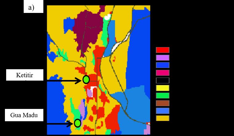
Amal Najihah Muhamad Nor, Rabiatul Adawiyah Isnorm, Muhamad Azahar Abas, Nur Hanisah
 Abdul Malek, Nor Hizami Hassin, Hasifah Abdul Aziz, Sharifah Aisyah Syed Omar and Nur
 Hairunnisa Rafaai

 The results indicate that the vegetation is still maintained but it needs to be conserved and
monitored to sustain the resources for future generation. Beside the development of
ecotourism within the new array of ‘green’ products and services, ecotourism claims to
combine environmental responsibility with the generation of local economic benefits that will
have both a development impact and serve as conservation incentives [14]

3.3. Landscape Structure Analysis
Based on Figure 3, the landscape structure of Ketitir lake vicinity surrounded by developed
building compares to Gua Madu which more to vegetation area being analyzed. Even though,
both of this area located mainly in the centre of Gua Musang. Table 3 shows the comparison
of all study areas as a potential ecotourisms sites in Gua Musang based on landscape metric
analysis at all study areas. Figure 3 and Table 3 indicate that the municipality of Jedip Village
has the highest land use of vegetation compared to other study areas.

 Figure 3 Patch analysis of a) Ketitir Lake, Gua Madu and b) Jedip Village based on land use type
 This is believed due to increase in the number of patches, a decrease mean patch area and
the reduction of largest patch index (Table 3). While water body has lower number of

 http://iaeme.com/Home/journal/IJCIET 975 editor@iaeme.com
Landscape Ecological Assessment of Potential Ecotourism in Malaysia

patches, mean patch area and the largest patch index in the Jedip Village. The comparison
between Gua Madu and Ketitir Lake show a slightly significant different in this four
landscape patches (Figure 3). The area of both places is near and located at the centre of Gua
Musang. The number of a patch of Gua Madu and Kititir Lake is similar. While patch density
of Ketitir Lake is higher compared to Gua Madu. The mean patch area was decreased and
reduction of largest patch index because of human development and their activity.

Table 3 Comparison among landscape metrics on study areas potential on ecotourism in Gua Musang
 based on land cover types.
 Landscape Land Use Land Cover type
 Metrics/Places Vegetation Built up area Cleared land Water bodies
 NP
 GuaMadu 91 34 30 25
 Ketitir Lake 91 38 37 4
 Jedip Village 94 2 3 59
 PD
 GuaMadu 0.05 0.10 0.30 0.12
 Ketitir Lake 0.10 0.15 0.42 0.10
 Jedip Village 0.40 0.04 0.28 0.05
 AREA_MN
 GuaMadu 1576 28050 372 15.62
 Ketitir Lake 1560 28040 400 15.61
 Jedip Village 39185 439 185 190.00
 LPI
 GuaMadu 106.36 6.40 1.41 0.30
 Ketitir Lake 104.36 10.40 5.41 0.24
 Jedip Village 161.04 1.80 0.76 0.28
Note: NP: Number of patches, AREA_MN: Mean patch area (ha), PD: Patch density (patch
number/100ha), LPI: Largest patch index
Generally, the population distribution of local community will affect the potential of
sustainable ecotourism in sustaining the ecotourism [15] because the local community
distributes their land, vegetation, facilities and management to improve the overall condition
of ecotourism in Gua Musang. This can be more specifically followed ecotourism
development needs to consider additional environmental problems which can be controlled
using sustainable ecotourism site planning areas to minimize the fragmentation and
duplication of planning in this study areas. Aforementioned, Ketitir lake and Gua Madu
located in the centre of Gua Musang. Therefore, these areas have more development and
easily assessed by visitors [16,17]. According to Gua Musang District Council, Ketitir Lake
is a former mining area that been transformed into a recreational area that makes attraction of
many people to on-going their activity. Gua Madu natural attraction of the caves and bees
that surrounded by forest and near to the Nenggiri River. On the other hand, Jedip village
area vicinity surrounded by vegetation especially on the mixed plantation. As proved, the
Jedip villager, Temiar tribe exposed their activity on planting cassava honey opposite their
house area.
 Therefore, the effect on this natural attraction and human activity develop the factor on
the fragmentation as the change of this both place been observed and analyze. For examples,
Ketitir Lake has potential on highly fragmented land structure compare to Gua Madu and
Jedip Village. Land cover and landscape changes represent an important and sensitive
indicator that echoes the interactions between human activity and the natural environment
[18]. Therefore, it can be seen the Jedip village (Figure 3) have the potential to be a suitable
place for doing an ecotourism activity with large space and easily assessed. Next is Gua

 http://iaeme.com/Home/journal/IJCIET 976 editor@iaeme.com
Amal Najihah Muhamad Nor, Rabiatul Adawiyah Isnorm, Muhamad Azahar Abas, Nur Hanisah
 Abdul Malek, Nor Hizami Hassin, Hasifah Abdul Aziz, Sharifah Aisyah Syed Omar and Nur
 Hairunnisa Rafaai

Madu as it is natural ecotourism site in Gua Musang with the geographical structure of the
cave with honey bees. The least potential is Ketitir lake as it been exposed the attraction of
people to do ecotourism activity like a recreational activity, the activity such as jogging,
walking, cycling, and paddle boat in the lake.
 High accessibility and demand for ecotourisms leads to the increasing of landscape
fragmentation when the uncontrolled development happened [19]. According to Marzuki et
al. [20], a control development is required to achieve a sustainable ecotourims at any
ecotourims site. Therefore, the landscape fragmentation can be highly occur in Ketitir Lakes
compared to Gua Madu, while Jedip Village have a potential to be fragmented due to
uncontrolled development. The relationship between spatial pattern and ecological processes
was not restricted to a particular scale [21] by quantifying the degree of fragmentation
requires measuring the pattern of habitat on the landscape [22]. Thus, the most potential
ecotourism site to be more sustainable between the study areas is Gua Madu

3.4. Relationship between the Landscape Structure Pattern and Ecotourism
Activity
The significant correlation analysis (r2) between land use type area and ecotourism activity is
0.6. This means there is strong significant correlation between all the ecotourism activity
done in the type of land use. Based on the correlation analysis, Gua Madu is the most
potential ecotourism area. Gua Madu usually visited by family and group vacation to have the
sightseeing at the bridge connected with Kampung Batu Papan to see the Neggiri river,
recreational activity, and cave hiking. Cited by Irhanida [23], Gua Musang could benefit from
being more interesting place of its role and its relationship with other tourism destinations
that travelers visit before and after their arrival. Therefore, attraction place most basically
focused toward recreational activity then followed with the picnic with family, sightseeing
and the least is caves hiking. Besides, the caves hiking is attracted mostly to the tourist who
loves in the adventurous and challenging game as deposited their memorable and enjoyable
visit

3.5. Determination of Potential Ecotourism Activity for Sustainable Ecotourism
It is expected the tangible relationship between the potential ecotourism activity and local
land use type in the study areas in Gua Musang is strongly significant with the value 0.6
which are more than 0.5. The landscape metric analysis is a lower number of the patch and
increases in patch density in Gua Madu with the correlation significant compare to Jedip
Village and Ketitir Lakes OR The landscape metric analysis shows the lower number of the
patch and increases in patch density in Gua Madu with the correlation significant compare to
Jedip Village and Ketitir Lakes.

4. CONCLUSION
Gua Madu is the most potential ecotourism as it has a good arrangement of landscape
structure. The patch of Gua Madu has the lowest number, largest patch index and favorable
place based on the ecotourism activity compare to Ketitir Lake and Jedip Village. However,
excessive logging activity causes a lot of pollution especially water and soil pollution that
effects local business in ecotourism and ecotourism activities. Therefore, it is suggested by
the Head of Jedip Village to gazette the indigenous community areas to ensure the continuity
of their role in sustaining the diversity of cultural and biological landscape. Therefore, Gua
Musang act as a model for a landscape ecology approach to assessing the potential of

 http://iaeme.com/Home/journal/IJCIET 977 editor@iaeme.com
Landscape Ecological Assessment of Potential Ecotourism in Malaysia

ecotourism to be developed as a sustainable area. This can be linked with the local people as
the distribution of the local population in Gua Musang will affect the study of the potential of
sustainable ecotourism in Gua Musang.

ACKNOWLEDGEMENTS
Special thanks to Universiti Malaysia Kelantan and Institut Perubahan Iklim, Universiti
Kebangsaan Malaysia for providing facilities and support for this research. This research
partially supported by short term grant project funded by Universiti Malaysia Kelantan
(R/SGJP/A.08.00/00793A/001/2018/00476) and Kursi Perubahan Iklim UKM-YSD
(R/YSD/A08.00/00793A/002/2018/000542) funded by Institut Perubahan Iklim UKM. This
work presents the outcomes of independent research funded by Universiti Malaysia Kelantan
and Institut Perubahan Iklim, Universiti Kebangsaan Malaysia, and the view expressed are
those of the authors and not necessarily those of the Short Term Grant Directorate.

REFERENCES
 [1] Gil, M. A., Renfro, B., Figueroa-Zavala, B., Penié, I., & Dunton, K. H. 2015. Rapid
 tourism growth and declining coral reefs in Akumal, Mexico. Marine biology, 162(11),
 2225-2233.
 [2] World Tourism Organization. 2000. Tourism 2020 Vision, Vol. 4. Europe, Madrid, World
 Tourism Organization.
 [3] Allcock, A., & Evans-Smith, D. 1994. National ecotourism strategy. Commonwealth
 Dept. of Tourism.
 [4] Naughton-Treves, L., Holland, M. B., & Brandon, K. 2005. The role of protected areas in
 conserving biodiversity and sustaining local livelihoods.Annu. Rev. Environ. Resource.,
 30, 219-252.
 [5] Kirstges, T. 2000. Case study of Basic questions ‘Sustainable Tourism’:Does Ecological
 and Socially Acceptable Tourism has a chance?.Book of Global Ecotourism Policies and
 Case Studies,Perspective and Constraints.Michael Luck and Torsten Kirstges, 1-21
 [6] Neth, B. 2008. Ecotourism as a tool for sustainable rural community development and
 natural resources management in the Tonle Sap Biosphere Reserve. Kassel university
 press GmbH.
 [7] Anderson, J. R. 1976. A land use and land cover classification system for use with remote
 sensor data (Vol. 964). US Government Printing Office.
 [8] Priskin, J. 2001. Assessment of natural resources for nature-based tourism:: the case of
 the Central Coast Region of Western Australia. Tourism Management, 22(6), 637-648.
 [9] Fadlon, L., & Valeri, M. 2016. Sustainability in tourism: an originality and hospitality
 business in Italy. Tourismos, 11(1).
 [10] Gua musang 2013
 [11] Azlan. I 2011. Interact With The Land: Exploring The Potential Of Jungle Railway For
 Eco-Tourism Opportunities. Dept of Landscape Architecture, Faculty of Architecture,
 Planning and Surveying, Universiti Teknologi MARA Malaysia
 [12] Regis, P. 2000. Nature-Based Tourism: An Approach to The Management Of Protected
 Areas In Sabah. The World Commission On Protected Areas, 2nd Southeast Asia
 Regional Forum, Pakse, Lao PDR, 6-11 December 1999 (Vol. 2, p. 313). IUCN Lao
 PDR.
 [13] Nadia, W. Q., Siti-Munirah, M. Y., Zulhazman, H., & Razak, W. 2012. A Preliminary
 Study on the Mortality Rates of Rafflesia kerrii in the Lojing Highlands, Gua Musang,

 http://iaeme.com/Home/journal/IJCIET 978 editor@iaeme.com
Amal Najihah Muhamad Nor, Rabiatul Adawiyah Isnorm, Muhamad Azahar Abas, Nur Hanisah
 Abdul Malek, Nor Hizami Hassin, Hasifah Abdul Aziz, Sharifah Aisyah Syed Omar and Nur
 Hairunnisa Rafaai

 Kelantan, Malaysia. Conference: UMT 11 th International Annual Symposium on
 Sustainability Science and Management, Terengganu, Malaysia
[14] Wunder, S. 2000. Ecotourism and economic incentives—an empirical approach.
 Ecological Economics, 32 (3), 465-479.
[15] Phwan C. K., Yvonne K. W. S, Chin S. K., and Tan Y, F., and Nor A.N.M., 2013.
 Satisfaction Of local community and tourist at Tanjung Emas, Muar for potential
 ecotourism. In: National Conference on Higher Education Institution and Community
 Engagement 2013 : towards making higher education institution relevant to community,
 29 - 27 Aug 2013, Universiti Malaysia Kelantan , Jeli Kampus.
[16] Nazaruddin D.A., Khan M.M.A., Fazil S.R., Zulkarnain Z., Raman K. 2017. Geological
 Assessment of Water-Based Tourism Sites in Jeli District, Kelantan, Malaysia. In:
 Abdalla O., Kacimov A., Chen M., Al-Maktoumi A., Al-Hosni T., Clark I. (eds) Water
 Resources in Arid Areas: The Way Forward. Springer Water. Springer, Cham
[17] Nazaruddin, D., Armugam K., Wahab, R., Nor, A.N.M., and Fauzi, N. 2013.
 Identification of Natural Resources and Features for Ecotourism Purposes in the Kelantan
 Delta Area, Malaysia. International Journal of Sciences (03), Vol 2.
[18] Nor, A. N. M., Corstanje, R., Harris, J. A., & Brewer, T. 2017. Impact of rapid urban
 expansion on green space structure. Ecological Indicators, 81, 274-284.
[19] Nor, A. N. M., Corstanje, R., Harris, J. A., Grafius, D. R., & Siriwardena, G. M. 2017.
 Ecological connectivity networks in rapidly expanding cities. Heliyon, 3(6), e00325.
[20] Marzuki, A., Hussin, A. A., Mohamed, B., Othman, A. G., & Puad, A. 2011. Assessment
 of nature-based tourism in South Kelantan, Malaysia. Tourism: An International
 Multidisciplinary Journal of Tourism, 6 (1), 281-295.
[21] Sanderson, J., & Harris, L. D. 2000. Landscape ecology: a top-down approach. CRC
 Press.
[22] Fahrig, L. 2003. Effects of habitat fragmentation on biodiversity. Annual review of
 ecology, evolution, and systematics, 487-515
[23] Irhanida, A. K. 2008. The study of tourist flows and travel movement in Gua Musang
 (Doctoral dissertation, Universiti Teknologi Malaysia, Faculty of Built Environment).

http://iaeme.com/Home/journal/IJCIET 979 editor@iaeme.com
You can also read