Land Squandering in the Spanish Medium Sized Cities: The Case of Toledo - MDPI
←
→
Page content transcription
If your browser does not render page correctly, please read the page content below

Article
Land Squandering in the Spanish Medium Sized
Cities: The Case of Toledo
Irene Sánchez Ondoño 1 and Luis Alfonso Escudero Gómez 2, *
 1    Department of Geography, University of Castilla-La Mancha, 02071 Albacete, Spain;
      irene.sanchezondono@uclm.es
 2    Department of Geography, University of Castilla-La Mancha, 45071 Toledo, Spain
 *    Correspondence: luisalfonso.escudero@uclm.es; Tel.: +34-925268800-5312

 Received: 31 December 2018; Accepted: 24 January 2019; Published: 27 January 2019

 Abstract: A process of land squandering began in Spain in the mid 1990s until the great crisis of
 2008. The intensive production of urban land affected the Spanish medium-sized towns. They were
 characterized by their compact nature and then they underwent an intense diffuse urbanization.
 However, in some cases there had been previous examples of urban sprawl. In this article, we study
 one of them, the unique and historic city of Toledo, in the Centre of the Iberian Peninsula. We will
 show how the city has experienced the land squandering and has been extensively widespread
 throughout the hinterland, consisting of their peripheral municipalities. We will also check how
 Toledo has had a previous internal dispersion process in the last quarter of the 20th Century through
 the called Ensanche (widening). We will use the urban estate cadaster as a fundamental source for
 evolutionary and present analysis of the city and its hinterland. The field and bibliographic work
 complete the methodology. The final conclusion is that there have been remarkable urban increments
 in Spanish medium-sized cities such as Toledo, in external and peripheral districts, under the logic of
 speculation and profit, resulting in a disjointed space.

 Keywords: urban geography; urbanism; urban growth; medium-sized city; suburbanization; Spain

1. Introduction
      The processes of urban growth have been usually associated with large cities and coastal towns
with great influence in the sector of tourism. However, the interior medium-sized cities have also
taken part of morphological and territorial transformation processes. These urban entities have been
of undoubted scientific interest, however, there is not absolute consensus with its definition. Roger
Brunet, given such complexity, came to define them as UGO, standing for Unidentified Geographic
Object [1].
      The term of medium-sized city has its origins in France [2]. In the Spanish context, early work on
medium-sized cities dates back to the 1980s [3–5]. They tried to clarify some of the most significant
features of these cities in Spain and, although no definition is required, it can be noted how the size of
the population was the best exponent for the definition of this urban reality.
      Also, the problems arising around Barcelona and Madrid and the complex territorial articulation
of their metropolitan areas will lead to a reflection that places medium-sized cities as elements of
territorial cohesion [6]. Over the years, they are associated with positions of urban equilibrium and
conceived as more urban spaces, having more apprehensible scales for their citizens [7,8].
      With the turn of the century, the term intermediate city was almost generally accepted. Then,
a new door of debate on the problems of conceptualization was open, medium-sized cities had been
affected by intense processes of change that inevitably forced to study the urban hierarchy within the
international context influenced by the complex logic derived from globalization. Thus, intermediate

Urban Sci. 2019, 3, 16; doi:10.3390/urbansci3010016                           www.mdpi.com/journal/urbansci
Urban Sci. 2019, 3, 16                                                                                  2 of 17

cities are characterized by the role played in the territory not only regarding the capacity to articulate
their environment but also regarding the influence that they generate and the relationships that they
are able to establish with other spaces. In short, it must be highlighted their role as carriers of goods
and services to those cities and/ or rural municipalities on which they exert influence. In addition,
their ability to connect different levels of networks (at a local, national, and even international level) is
remarkable [9].
      The definition of intermediate cities with their clear vocation of intermediation, left the
quantitative criteria behind to conceptualize from the explanation of qualitative, economic, functional
and territorial factors, where the capacity to organize more balanced urban systems with a higher
quality of life is essential [10].
      The most recent studies on medium-sized cities have been approached from different perspectives
(scattered and oversized growths-in most cases-which leave the traditional compact city model aside)
that share one thing in common: the model of diffuse city. However, the term is not subject to a
concise definition. On the contrary, and it is the same as with the concept of medium-sized cities, this
reality associated with urban sprawl does not have a clear definition since their building density, the
morphological typologies, the intensity of use and/or the possible territorial effects to which urban
dispersion refers are unknown [11].
      This phenomenon has been characterized from different terms that come to represent a similar
reality: city-region [12], urbanized field [13], diffuse city model [14], city sprawl [15], no city [16],
inefficient city [17]. The explanatory processes that derive in this situation are also complex
and are hidden under vague terminologies: Urban Sprawl [18], Counter-urbanization [19], and
Suburbanization [20].
      Defining and specifying its characterization is complex. However, it is a structural process that
reorganizes the urban form from the displacement of population and activities to the periphery of the
cities. In Spain, it has been strengthened, among other factors, by the modernization of the production
system, the use of new technologies, the continuous increase of accessibility, the availability of land
with more competitive prices, the widespread use of private vehicles, and the change in demand
preferences [21].
      Thus, it can be corroborated how the urban growth has spread to the periphery of the
medium-sized cities in the last decades [1]. An intensive process of urbanization at the expense
of neighboring rural municipalities [22] has taken place in most of them. The trend in these nuclei
and areas is the progressive occupation of the territory, which takes part of the residential function,
until recently reserved to the central city [23]. Large urban areas that have substantially modified the
structure and the characteristics of the medium-sized cities and their peripheries have been formed.
      The new logic of urbanization that appeared in recent decades in these cities has altered its
traditional, compact, intense, and dense structure. They have given way to new forms, extensive
territorial and more scattered structures, accompanied by morphological, functional and social
transformations [24].
      Chronologically the existence of two very distinct stages can be emphatically stated: an initially
exaggerated growth that begins to be noticed in the middle of the 1990s and the first years of the 21st
century, called by some authors “the prodigious decade of urbanism” [25] or “urban tsunami” [26];
and a second phase where the model that had been raised years ago comes to an end by its own
unsustainability, leading to a deep economic crisis that eventually burst in 2008 [27].
      Since the 1980s, and primarily between 1990 and up to the 2008 crisis, an intense process of
dispersed urbanization affecting medium-sized cities occurred in Spain [28]. There are recent dynamics
related to the real estate boom and the increasing artificialization of soil in 2000 [29]. In fact, the nearby
municipalities now play a residential function that is associated with the increase in daily movements
between home and place of work [23]. We must also add urban planning that encouraged the expansive
growth based on considering large tracts of land as urban and thus encouraging urbanization [30].
Urban Sci. 2019, 3, 16                                                                               3 of 17

      The result has been that these cities have gone from more or less continuous, and compact
structures, especially in the interior and provincial capitals, to others more dispersed and discontinuous
that extend over their respective urban areas [31]. It is a new model of residential production that has
resulted in a dispersed urban territory [32]. The model of suburbanization has deeply permeated with
the growth of cities towards its peripheries. In medium sized cities we can see urban decentralization,
peri-urbanization, and the formation of low density frames, analogous to the processes of soil expansion
and consumption [23]. Thus, a supra-municipal city is created, generated by the sum of fragments
without continuity in its urban fabric [33]. This recent growth in diffuse medium urban areas has
meant a strong intake of soil and considerable environmental consequences [34].
      This process of speculative urban growth related to neoliberal capitalism is of great interest for
the above-mentioned scholars focused on urban studies [35–38]. Spain is a good example of it within
the urban sciences in recent years and the phenomenon has been analyzed as a whole. There have
been studies since the end of the 20th century [39], which already had a concern about urbanism
that would be applied in the 21st century and some recommendations were given but they were not
applied [40]. On the other hand, there was a process of appropriation of the incomes of the soil in the
neo-liberal Spanish city, which resulted in land squandering [41] and, after the crisis, there was a profit
topography characterized by its modern ruins [42] and serious social and territorial consequences [43].
Lois, Piñeira and Vives deeply, synthetically and completely describe this urbanization process that
has taken place in Spain in the last decade of the 20th century until the great recession that began in
2008 [44]. Today, scholars proclaimed the necessity of overcoming this model of building [45].
      More specifically, they also tried to understand the expansion of the urban peripheries and new
spatial forms that are generated in the Spanish cities [46] and the challenge of sustainability that
has been generated [47]. In a concrete way, the dynamics of the area of concern to this research,
the Ensanches (widenings) are studied by Coudroy de Lille [48]. In Spanish urbanism Ensanche is
an extension of the first comprehensive planned development outside of the historic centre and its
proximity in each city, although chronologically the first and authentic Ensanches are of the 19th century
and beginning of the 20th century, in cities like Toledo, characterized by its atony, become much more
contemporary phenomena.
      In addition, case studies have been spread in order to understand the process of a more extensive
and specific way. A case study is a research approach that facilitates the exploration of a phenomenon
within a specific context using a variety of sources of data [49]. These studies are mainly focused on the
large metropolitan areas of Spain, with a great interest in those of Barcelona [50,51] and Madrid [52,53].
There are also essays based on large cities within the Spanish urban system. Thus, Díaz Parra [54]
discusses the growth of Seville as a production of a commodity for the logic of neo-liberal capitalism
and Escolano, López, and Pueyo study the case of Zaragoza [55] in the first fifteen years of the 21st
century as an example of neo-liberal urbanism and urban fragmentation. Case studies of medium-sized
cities as Albacete [56] or Burgos [57] have also been published.
      In this article we study the medium sized city of Toledo, with a population of 83,741 inhabitants
in 2017 [58], and a diffuse growth that has spread to the municipalities that surround it. How has the
land squandering taken place in the medium-sized cities of Spain, as in the case of Toledo? This is the
first research question. The first objective of the research is to analyze this process. But, immediately,
a question about its novelty came out. Before the recent process of diffuse city we referred to a model
that characterized the medium sized cities as compact [31]. Was it always this way? In other words,
did the Spanish medium-sized cities have examples of urban dispersion before the recent diffuse
urbanization process towards the peripheral municipalities? Did compact but, at the same time,
equally unconnected growth occur? These are the second and third research questions. These research
questions are answered in the second part of the article: a case study of the so-called Ensanche of Toledo.
Through this example, it can be observed that a speculative urban growth had already resulted in
Toledo in fragmented spaces.
Urban Sci. 2019, 3, 16                                                                               4 of 17

      Toledo is located at latitude 39◦ 510 2400 North and longitude 4◦ 10 2800 West, in the center of the
Iberian Peninsula, in the so-called South Plateau and about 70 km south of Madrid, capital of Spain. It
is inserted within the autonomous community of Castilla-La Mancha, an inner region characterized
by low demographic density and relatively stable population dynamics in recent decades. One of its
most notable features is that the distribution and size of cities have not allowed the establishment of
a regional capital capable of organizing the rest of the urban nuclei [59]. This derives its status as a
acephalous region and the great influence of Madrid on the territory of Castilla-La Mancha, especially
striking in the case of Guadalajara and Toledo (autonomic capital) [60].
      In such a way, Toledo, standing as a medium-sized city with a status of regional administrative
center, belongs to an urban agglomeration of higher level (Madrid), has a high tourist attraction
derived from its declaration as a World heritage City by UNESCO and organizes a wide rural area [61].
      To understand the dynamics of urban growth in Toledo, it is necessary to take into account
different peculiarities of geographic type, historical type-related to the multiple archaeological
finds [61], and legislative type. Regarding the first, the Tagus river is the main key to understand the
actual configuration of the current space. Around it, you can notice up to four types of landscapes:
historic center, the peri-urban area called “Los Cigarrales”, Las Vegas del Tajo, and the northern
spaces [58].
      Legislative-type reasons are directly linked to the absence of territorial planning that allows an
orderly connection to the city of Toledo. In this sense, it is worth highlighting the disarticulation in the
urban development of the city by the lack of a model of growth coherently managed from the different
urban planning plans that they have had in Toledo” [62].
      The structure of the article fits the presented speech: an introductory part, a second part analyzing
the dispersion of Toledo towards their peripheral municipalities, and a third part studying the Ensanche.
      The article is located in the current research on the medium-sized cities and in the processes
observed in their central core and respective urban areas.
      The inclusion of the paper in the special issue “Land Squandering and Social Crisis in the Spanish
City” is perfectly justified by observing the changes that have taken place as well in the urban area
of Toledo as in the central city. These morphological transformations have been derived from the
different economic, social and political processes that have been developing in the Spanish context in
the 21st century.
      In addition, the tendencies appreciated in the city of Toledo and its hinterland coincide with
the dynamics given throughout the national territory, observing a period of growth that ends in
2008. Currently, there is an open discussion around the problems caused by a model that has been
unsustainable in most cities in Spain.

2. Methodology
     The research starts from the study of the growth of the city of Toledo in relation to the urban
morphology. For the analysis of the urban sprawl of Toledo and the municipalities that are in their
area of influence has been proceeded to the analysis of indicators that allow to study the evolution
of the soil that has been urbanized and/or constructed. The importance is not exclusively confined
to the main city (Toledo) but it is intended to observe the dynamics, derived from the processes of
suburbanization, given in the municipalities that make up the suburbs. This has established a 30-km
hinterland around the central city that allows us to know the area of urban sprawl. The analysis unit of
the study has been the municipality, as long as it is considered as the basic local entity of the National
Territorial Organization. The use of this unit allows us to study the added behavior of the city suburbs
of Toledo. However, there are also some difficulties arising from the great variety in terms of area and
population existing between municipalities.
     Other factors that can determine the study are also highlighted. In this case we refer to the
importance of the situation of the elements studied with respect to the main routes of communication,
the proximity to Madrid and/or Toledo. From the temporal point of view, the period 2000–2016 has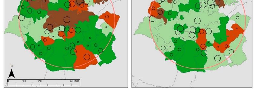
Urban Sci. 2019, 3, 16                                                                              5 of 17

been selected, which has been analyzed from different perspectives. In order to establish similarities
or differences, the variables have been analyzed separately around two completely distinguished
moments: a first cycle originating from the beginning of the 21st century and culminating in the year
2008 with the crash of the economic crisis that same year and a later period until the year 2016. In
these two phases, very adverse behaviors can be distinguished in the real-estate sector and in the
construction of cities. The particularly abrupt recess caused by the crisis of the year 2008 led to a
huge change from the predecessor period, giving way to a new cycle defined by completely inverse
features, that is, a time of absence of dynamics in contrast with a growth excessive in most cases. The
methodology allows us to analyze what happened throughout the period according to the unequal
behavior of two periods that have the same number of years but are incomparable in turn by the logics
carried out.
      The objective of studying the whole period (2000–2016) around the built surface and surface not
built is to verify the differences between the hectares of land that have been urbanized and those that
were urbanized and materialized in the practice, that is to say, those that were actually built.
      Thus, the variables used have been population, surface of built urban areas and surface of urban
area without building. The first one has been obtained from the data provided by the National Institute
of Statistics, while the remaining ones have been downloaded from the website of the land registry.
      The cartography of the first part of the work shows a series of intervals that aim to reflect the
different behavior of the municipalities. This always establishes a negative value and an increase
ranging from: moderate growth rates 0–50, high growth 50–100 and very high growth more than
100). Summary-tables have also been used to introduce the data that have been believed to be
most significant.
      The analysis around the Ensanche of Toledo allows us to analyze the temporal evolution of the
shaping of the widening over the period from 1950 to the present, as well as the structuring and uses
of its use. To show such results, cartographic representation has been proceeding. Taking for granted,
the methodology has been completed with fieldwork and a bibliographical review.
      The article is located in the current research on the medium-sized cities and on the processes
observed both in its central areas and in their respective urban areas.

3. Results

3.1. The Urban Area of Toledo: An External Dispersion
      Toledo is located at latitude 39◦ 510 2400 North and longitude 4◦ 10 2800 West, in the center of the
Iberian Peninsula, in the so-called South Plateau and about 70 km south of Madrid, capital of Spain. It
is inserted within the autonomous community of Castilla-La Mancha. The city of Toledo has actively
participated in the process of urban growth that has spread to the outskirts of Spanish medium-sized
cities in recent decades [63]. Thus, there has been an intense urbanization in their neighboring
municipalities. This section discusses this aspect through demographic data and the evolution of the
surface built between 2000 and 2016 by the land registry. To study the outskirts of the central city we
choose to establish a hinterland of 30 km and we take into consideration all its municipalities.
      From the demographic point of view, and in response to Figure 1, the most populous
municipalities of the province of Toledo in the year 2016 correspond to the capital city and Talavera de
la Reina, with a population of 83,459 and 84,119 inhabitants respectively. This is a reality that does
not represent the vast majority of the municipalities of Toledo, which do not exceed the number of
5000 inhabitants (175 of a total 204). Immediately thereafter, the major municipalities are concentrated
in the hinterland of the 30 km of Toledo and in the North area with respect to the capital city, adjoining
with the province of Madrid.
      Table 1 shows the municipalities 30 km away fromToledo that have acquired rates of population
variation over 50% between 2000 and 2016. Up to 18 of them meet this premise with percentages
ranging from 65% of Recas to 605% of Barcience. In fact, a total of 9 municipalities have seen their
Urban Sci. 2019, 3, 16                                                                                                  6 of 17

population doubled or more in the last 15 years. The demographic dispersion in the urban area of the
medium-sized
Urban Sci. 2019, 3, xcity
                      FORand
                          PEERcapital
                               REVIEWof Castilla-La Mancha, Toledo, is evident.           6 of 18

      Figure 1.
      Figure 1. Total
                Total population
                      populationinin2016
                                     2016and growth
                                           and  growth rate in in
                                                         rate  thethe
                                                                   province of Toledo
                                                                      province         by municipalities
                                                                                of Toledo                for the
                                                                                          by municipalities   for the
      period 2000–2016.  Source: INE  [58] and self-elaboration.
      period 2000–2016. Source: INE [58] and self-elaboration.

      Table1.1 Municipalities
     Table                         of the urban 30
                  shows the municipalities        area  of Toledo with
                                                      kilometers    awaya fromToledo
                                                                          growth rate exceeding
                                                                                         that have50%     between
                                                                                                    acquired        2000
                                                                                                                 rates of
     and 2016variation
population        Source: INEover[58].
                                   50% between 2000 and 2016. Up to 18 of them meet this premise with
percentages ranging from 65% of Recas to 605% of Barcience. In fact, a total of 9 municipalities have
                                                                                                      Variation Rate
              Municipality doubledPopulation
seen their population                   or more in2000      Population
                                                     the last 15 years.2008     Population 2016
                                                                         The demographic      dispersion   in the(%)
                                                                                                                   urban
                                                                                                       2000–2016
area of the medium-sized
                 Barcience        city and  capital
                                             111     of  Castilla-La
                                                                  481  Mancha,  Toledo,783is evident.       605
      OneChozas
            of thede variables
                        Canales that can help
                                            1002 to realize the effects
                                                                  3485 of urban sprawl3710 is the surface of270built and
          Burguillos de Toledo               965                  2399                3092                  220
unbuilt urban plots. The used information has been extracted from the cadaster [64]. So, it has been
                  Magán                     1137                  2738                3225                  184
selected for Toledo
                  Yuncos and its area of 3760
                                            influence, 30 km, 8623the area of urban10,613
                                                                                       plots, both built and182 unbuilt,
for the years 2000,Cobisa2008 and 2016 in   1618
                                              order to identify3645                   4186
                                                                    the dynamics occurred                   159
                                                                                              before (2000–2008)     and
                   Argés                    2477                  5178                6093                  146
after theCedillo
           crisis del
                    (2009–2016).
                        Condado
                                   In  Figure  2
                                            1542
                                                 the  results are  mapped.
                                                                  2520
                                                                             You   can  see
                                                                                      3680
                                                                                             how the  surface
                                                                                                            139
                                                                                                                of urban
plots has varied       considerably in the268
                   Layos                      two periods mentioned.
                                                                   444     Between 2000625 and 2008 a strong133 growth
of the surface  Lominchar
                      built in the central  1198core of Toledo    1735
                                                                     and its Northern 2365and Southern 97    peripheral
                  Yuncler                   1855                  3161                3648                   97
municipalities
         Numanciatakes       place. With respect
                      de la Sagra           2555     to the period,
                                                                  4448 2009–2016, the    dynamic presents
                                                                                      4734                   85 different
features. There      are many more municipalities
                Palomeque                    483           with negative
                                                                   878     rates, a direct
                                                                                       876 result of the effects
                                                                                                             81    of the
           Villamiel de Toledo               477                   812
crisis, although      some still keep growth      rates, although    they are lower. 857                     80
                 Novés                   1545                  2500                  2707                  75
               Nambroca                  2603                  3415                  4524                  74
              Olías del Rey              4287                  6413                  7357                  72
                  Recas                  2614                  3498                  4309                  65

     One of the variables that can help to realize the effects of urban sprawl is the surface of built and
unbuilt urban plots. The used information has been extracted from the cadaster [64]. So, it has been
selected for Toledo and its area of influence, 30 km, the area of urban plots, both built and unbuilt, for
the years 2000, 2008 and 2016 in order to identify the dynamics occurred before (2000–2008) and after
the crisis (2009–2016). In Figure 2 the results are mapped. You can see how the surface of urban plots
has varied considerably in the two periods mentioned. Between 2000 and 2008 a strong growth of the
Urban Sci. 2019, 3, 16                                                                                             7 of 17

surface built in the central core of Toledo and its Northern and Southern peripheral municipalities
takes place. With respect to the period, 2009–2016, the dynamic presents different features. There are
many more municipalities with negative rates, a direct result of the effects of the crisis, although some
still keep
   Urban Sci.growth     rates,
             2019, 3, x FOR    although
                            PEER  REVIEW they are lower.                                          8 of 18

        Figure 2. Growth rate of the built surface in the municipalities of the urban area of Toledo between
      Figure 2. Growth rate of the built surface in the municipalities of the urban area of Toledo between
        2000–08, and 2008-16. Source: Land Registry [64] and self-elaboration.
      2000–08, and 2008-16. Source: Land Registry [64] and self-elaboration.

         FromTable
       From      Table2 2we
                          wecan
                              canseeseethe
                                        theimportance
                                             importance that
                                                          that the
                                                                thehinterland
                                                                    hinterlandacquires
                                                                                 acquiresasas
                                                                                            a whole
                                                                                              a whole with respect
                                                                                                         with        to to
                                                                                                               respect
thethe  city
     city  ofofToledo.
                Toledo.TheThegroup
                              groupof  of municipalities
                                          municipalities located
                                                           locatedwithin
                                                                    withinthirty
                                                                            thirtykilometers,
                                                                                   kilometers,both  in in
                                                                                                 both  built-up  areas
                                                                                                          built-up   areas
   and   unbuilt   surface  for  the  three years  analyzed   represent  a clear superiority  to the central
and unbuilt surface for the three years analyzed represent a clear superiority to the central city. As        city.  As
forfor temporal evolution, in the year 2000 we can see the overall trends associated to the time with the
     temporal     evolution, in the year 2000 we can see the overall trends associated to the time with the
   greatest growth, thus grouping a total of 7900 hectares between built and unbuilt areas. Of course,
greatest growth, thus grouping a total of 7900 hectares between built and unbuilt areas. Of course,
   the role of the urban area is much more significant with respect to the city of Toledo (15% hectares of
the role of the urban area is much more significant with respect to the city of Toledo (15% hectares
   built-up area and 21.3% hectares of unbuilt surface compared to 85% and 78.7%). Indeed, the
of built-up area and 21.3% hectares of unbuilt surface compared to 85% and 78.7%). Indeed, the
   percentages of the hinterland always exceed, in greater or lesser extent, the central city. However, in
percentages of the hinterland always exceed, in greater or lesser extent, the central city. However,
   2008 Toledo managed to increase 19.7% of hectares of built-up area and 22.2% of hectares of unbuilt
in areas
    2008 Toledo     managed
           with respect   to thetoprevious
                                    increaseyear.
                                              19.7%Inof hectares
                                                      2016,        of built-up
                                                             the capital showsarea
                                                                                backand   22.2% ofdynamics,
                                                                                      descendant    hectares oflosing
                                                                                                                  unbuilt
areas
   5.8%with    respect
          of the built-upto the
                            area,previous    year.
                                   but tripling theIncorresponding
                                                      2016, the capital   shows
                                                                      hectares    back
                                                                               with  thedescendant    dynamics,
                                                                                         plots (17.4%).             losing
                                                                                                         The analysis
5.8%   of  the  built-up   area,  but  tripling the  corresponding     hectares  with  the plots (17.4%).
   of the data shows one of the symptoms of the change in the model of compact city to the sparse urban    The   analysis
ofarea.
    the data shows one of the symptoms of the change in the model of compact city to the sparse
urban area.
        Table 2. Evolution of the built-up and unbuilt areas between 2000 and 2016 in Toledo and in its
      Table 2. Evolution of the built-up and unbuilt areas between 2000 and 2016 in Toledo and in its
        hinterland of 30 kms. Source: Land Registry [64].
      hinterland of 30 km. Source: Land Registry [64].
                         Built-up
                          Built-upSurface
                                   Surface (Ha)
                                            (Ha)                                 Unbuilt
                                                                                  Unbuilt Surface (Ha)
                                                                                          Surface (Ha)
                     2000      %     2008      %      2016     %     2000      %     2008      %      2016      %
       Toledo        2000
                      853      %
                               15    2008
                                     2376.6    %
                                              34.7    2016
                                                     2106.0    %
                                                              28.9    2000
                                                                     834.1     %
                                                                              21.3    2008
                                                                                     3553.3    %
                                                                                              43.5     2016
                                                                                                      1388.4     %
                                                                                                               26.1
      Hinterland     4827.4   85     4471.2   65.3   5191.4   71.1   3072.6   78.7   4613.3   56.5    3934.0   73.9
      Toledo
        Total         853
                     5680.4   15
                              100   2376.6
                                     6847.8   34.7
                                              100    2106.0
                                                     7297.4   28.9
                                                              100    834.1
                                                                     3906.6   21.3
                                                                              100    3553.3
                                                                                     8166.6   43.5
                                                                                              100     1388.4
                                                                                                      5322.5    26.1
                                                                                                               100

    Hinterland      4827.4    85    4471.2    65.3   5191.4   71.1   3072.6   78.7   4613.3    56.5   3934.0    73.9
    Another important issue is related to the amount of built-up and unbuilt areas shown in Figure 3.
     Total      5680.4 100 6847.8 100       7297.4 100 3906.6 100 8166.6 100 5322.5 100
One of the conclusions that can be extracted having a look to the map is that the amount of developable
       Another important issue is related to the amount of built-up and unbuilt areas shown in Figure
  3. One of the conclusions that can be extracted having a look to the map is that the amount of
  developable surface generated in the period has been really excessive. If we look at the rate of
  variation of the built-up area for the period 2000–2016, we appreciate how five municipalities obtain
Urban Sci. 2019, 3, 16                                                                                             8 of 17

 surface generated in the period has been really excessive. If we look at the rate of variation of the
Urban Sci. 2019,
 built-up    area3, xfor
                      FORthe
                          PEER REVIEW
                             period 2000–2016,  we appreciate how five municipalities obtain values     9 of 18greater
 than 100%, this is the case of Burguillos de Toledo (106.27%), Toledo (146.90%), Novés (153.49%),
values greater than 100%, this is the case of Burguillos de Toledo (106.27%), Toledo (146.90%), Novés
 Villaluenga de la Sagra (156.58%), and Barcience (404.14%), a municipality that obtains a rate of
(153.49%), Villaluenga de la Sagra (156.58%), and Barcience (404.14%), a municipality that obtains a
 572.99% of the total area of urban plots (built and unbuilt) throughout the cycle.
rate of 572.99% of the total area of urban plots (built and unbuilt) throughout the cycle.
       But perhaps the unbuilt surface is really significant. Many municipalities have exceeded 100%
     But perhaps the unbuilt surface is really significant. Many municipalities have exceeded 100%
 of the rate of growth, but still the most striking are Layos 3,270% and Burujón 1,105%. Both greatly
of the rate of growth, but still the most striking are Layos 3,270% and Burujón 1,105%. Both greatly
 exceed 1000%! Barcience (753%), Magan (642%), Guadamur (609%), and Villaseca de la Sagra (607%)
exceed 1,000%! Barcience (753%), Magan (642%), Guadamur (609%), and Villaseca de la Sagra (607%)
 arebetween
are  between500 500   and
                    and    1000%.
                         1000%.     Below,
                                Below,  butbut
                                            alsoalso
                                                 withwith
                                                      veryvery
                                                           highhigh   values,
                                                                 values,       are Villaminaya
                                                                          are Villaminaya        (430.76%)
                                                                                           (430.76%)  AjofrínAjofrín
(363.19%), Toledo (327.11%), Camarenilla (264.31%), and Escalonilla (228.85%). As a reference, ToledoToledo
 (363.19%),   Toledo    (327.11%),  Camarenilla   (264.31%), and  Escalonilla   (228.85%).  As a reference,
 hasa agrowth
has      growthraterate
                      ofof 66.5%
                         66.5% of of unbuilt
                                  unbuilt    surface
                                          surface  andand 146.90%
                                                       146.90%       of built-up
                                                                of built-up  area.area.
       Ultimately,    approximately   half of the municipalities  of the  hinterland
     Ultimately, approximately half of the municipalities of the hinterland in Toledo in Toledo  within
                                                                                             within      a radius of
                                                                                                     a radius
of thirty kilometers exceeds growth rates of urban parcels higher than 50%, reaching really striking levels
 thirty  kilometers    exceeds growth   rates of urban  parcels higher   than 50%,  reaching  really striking
 in some
levels      cases.cases.
        in some

     Figure
       Figure3.3.Total
                  Totalofofurban
                            urbanarea
                                  areaand
                                        andurban
                                            urbandeveloped
                                                   developedarea
                                                               areainin2016
                                                                        2016and
                                                                             andgrowth
                                                                                 growthrates
                                                                                         ratesbetween
                                                                                               between2000
                                                                                                        2000and
                                                                                                             and 2016
     2016  in the hinterland   within a radius of 30 kilometers in Toledo.  Source: Land Registry [64] and self-
       in the hinterland within a radius of 30 km in Toledo. Source: Land Registry [64] and self-elaboration.
     elaboration.
       This way of showing the urban sprawl from the indicators that have been analyzed (built-up and
     This  way ofhelps
 unbuilt areas)   showing
                        us tothe  urban sprawl
                               understand   howfrom    the indicatorstsunami”,
                                                  the “urbanizing      that havecontinuing
                                                                                 been analyzed
                                                                                            with(built-up
                                                                                                  the metaphor
and  unbuilt  areas)  helps  us  to understand   how    the "urbanizing   tsunami",  continuing
 of Gaja [27], has reached the heart of the Iberian Peninsula and has resulted in dramatic       with  the
                                                                                                    increases in
metaphor   of Gaja [27], has  reached  the heart of  the Iberian Peninsula  and  has resulted in dramatic
 the built surface of the urban area of Toledo, at the same time that it entirely applied the rule that
increases in the built surface of the urban area of Toledo, at the same time that it entirely applied the
 everything is buildable [65] in a lot of their municipalities.
rule that everything is buildable [65] in a lot of their municipalities.
 3.2. Ensanche (Widening) of Toledo: An Internal Dispersion.
3.2. Ensanche (widening) of Toledo: An Internal Dispersion.
       The urban sprawl of Spanish medium-sized cities towards its periphery has resulted in a dispersed
      The urban sprawl of Spanish medium-sized cities towards its periphery has resulted in a
 city in Toledo, both within the central municipality and in the peripheral municipalities. Changing
dispersed city in Toledo, both within the central municipality and in the peripheral municipalities.
 from a central compact city to a scattered and fragmented urban area. However, Toledo already had
Changing from a central compact city to a scattered and fragmented urban area. However, Toledo
 a clear dislocation before the real estate boom and the intense urbanization process in the last years.
already had a clear dislocation before the real estate boom and the intense urbanization process in
the last years. Since the 1960s and up to the most contemporary transformation beginning in the
Urban Sci. 2019, 3, 16                                                                                                 9 of 17

Since the 1960s and up to the most contemporary transformation beginning in the 1990s, the city,
through two general plans of urban development, in 1964 and 1986, had already experienced an
internal scattering process through the so-called Ensanche [66].
      The emergence of a number of peripheral districts in the outskirts of Toledo takes place during
this urban growth, and they completely lack the urban agenda typical of the Spanish Ensanches of the
nineteenth-century. An urban planning was applied in a minority of cities [48] among which Toledo is
not included. In fact, the Laws for Ensanches of the 19th-century responded to the needs of growth of
the industrial city [48]. This requirement did not exist in Toledo. For this reason, the widening was not
proposed. And the one which would be eventually created, many decades later, responds to the model
Urban Sci. 2019, 3, x FOR PEER REVIEW                                                                                  10 of 18
of capitalist post-industrial town, and the speculative designs on the market.
1990s,ThetheEnsanche    of Toledo
              city, through         takes
                                  two      placeplans
                                        general  in the of
                                                         northern
                                                             urban part   of the municipality,
                                                                    development,       in 1964 andit started
                                                                                                        1986,inhadthealready
                                                                                                                      decade
of 1960–1970,     but   it is  mainly  developed    from   the  General   Plan
experienced an internal scattering process through the so-called Ensanche [66]. of  1986  (see Figure    4)  and  reaches   its
mostTheextreme    location,     the neighborhood     of Buenavista     in 2008.  It mainly   covers
            emergence of a number of peripheral districts in the outskirts of Toledo takes place duringPalomarejos,     Santa
Teresa,  Avenida
this urban growth,    de Europa
                          and theyand    Buenavista.
                                     completely    lackItthe
                                                          is located  in the area
                                                              urban agenda          known
                                                                               typical       as Spanish
                                                                                        of the  Vega Baja,    alluvial of
                                                                                                           Ensanches    plain
                                                                                                                           the
of the  river Tajo   downstream       from  the historic  centre, until  the slope   that closes
nineteenth-century. An urban planning was applied in a minority of cities [48] among which Toledothe   Valley   in the North.
This
is notisincluded.
         not a compact       urban
                      In fact,      development,
                                the Laws             but a of
                                           for Ensanches    space  built in different
                                                               the 19th-century         eras andtointerstitial
                                                                                    responded         the needsspaces     (see
                                                                                                                   of growth
Figure   5). The   expansion      does  not  form a  single   planned   set. On  the  contrary,  it  results
of the industrial city [48]. This requirement did not exist in Toledo. For this reason, the widening was      from   the sum
of
notsectors   situated
     proposed.      Andin  thethe Northern
                                one           part ofbeToledo,
                                     which would                 builtcreated,
                                                         eventually    in a longmany
                                                                                   temporal    process
                                                                                         decades    later,and    with ato
                                                                                                            responds     clear
                                                                                                                           the
dispersion    and fragmentation.
model of capitalist       post-industrial town, and the speculative designs on the market.

      Figure
      Figure 4.4. The  EnsancheofofToledo
                   TheEnsanche      Toledoinin
                                             thethe 1986
                                                  1986   PGOU.
                                                       PGOU.   Source:
                                                             Source: CityCity Council
                                                                          Council     of Toledo
                                                                                  of Toledo      [67] self-
                                                                                            [67] and  and
      self- elaboration.
      elaboration.

     The Ensanche of Toledo takes place in the northern part of the municipality, it started in the
decade of 1960–1970, but it is mainly developed from the General Plan of 1986 (see Figure 4) and
reaches its most extreme location, the neighborhood of Buenavista in 2008. It mainly covers
Palomarejos, Santa Teresa, Avenida de Europa and Buenavista. It is located in the area known as
Vega Baja, alluvial plain of the river Tajo downstream from the historic centre, until the slope that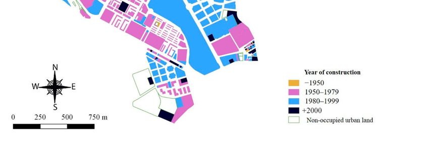
UrbanSci.
Urban Sci.2019,
2019,3,3,x16
FOR PEER REVIEW 1110ofof1817
Figure 5. Year of construction of the real estate of the Ensanche of Toledo. Source: own elaboration
based on CartoCiudad [68] and the land registry [64].
Figure 5. Year of construction of the real estate of the Ensanche of Toledo. Source: own elaboration
In this
based on way, the Ensanche
CartoCiudad [68] anddoes not registry
the land form a [64].
unit, but it is a mosaic of different neighborhoods.
Chronologically, the first one is Palomarejos. It was created in the decade of 1960 with public housing
In this
in order way, the
to absorb theEnsanche doesliving
population not form a unit, but housing
in substandard it is a mosaic of different
settlements in the neighborhoods.
municipality. Its
Chronologically, the firstblocks,
volume of rectangular one is Palomarejos.
and small-sized It was created indiffers
households the decade
fromofthe1960
restwith public
of the housing
sectors of the
in order to absorb the population living in substandard housing settlements in the municipality.
Ensanche. Despite being a public performance, it was not executed as it was planned. Thus, Palomarejos Its
volume of rectangular
is abruptly blocks, side.
cut on its western and small-sized households
It’s a neighborhood differs
locked from
up in thebyrest
itself of thearchitecture.
its own sectors of the
Ensanche. Despite being a public performance, it was not executed as it
Santa Teresa and Avenida de Europa, on the other hand, are sectors of towers of middle was planned. Thus,
and
Palomarejos
upper-middle is abruptly cut on its
class, of mainly western
private side. constructions.
housing It's a neighborhood
They locked up in itself
are expensive and by its own
speculative
architecture.
real estate products. However, urban problems appear again. Santa Teresa is also an incomplete
neighborhood radically cut by the West. Here we find a wide interstitial space, today used as free
parking outdoor. The aim was to make a great urban performance which included the presence of
a department store. The autonomous Government stopped this process due to the emergence of
important archaeological sites and social pressure [69]. The area known as Avenida de Europa presented
a regular map, but with sloping topography. Despite the quality of the buildings, it is a clearly
fragmented and unattractive neighborhood for passers-by from the rest of the city. Their volumes and
forms gave rise to another differential unit in the contemporary landscape of Toledo, in the East of the
Ensanche (see Figure 6).
Finally, the distant district of Buenavista is located in the North of the Ensanche. The duration of
the process of urbanization has been extended (see Figure 5). It still possesses large empty building
spaces. The interests of itsFigure
builders and promoters
6. Panoramic have
view of the marked
Ensanche the times and the irrational urban
of Toledo.
fabric of this sector is out of all urban logic. A wide variety of building types and volumes are mixed
Santa The
together. Teresa andspaces
public Avenidaarede Europa, onand
disconnected the aother
greathand,
part ofarethe
sectors of towers
built areas of middle
consists of commonand
upper-middle
private spaces.class,
It is of mainly
also private housing
very common to find constructions.
the typology ofThey areblocks
closed expensive and speculative
of buildings. real
The sloping
estate products.
topography However, urban
also contributes problems appear
to the unstructured natureagain.
of thisSanta Teresa is also an incomplete
industry.
neighborhood radically cut
The fragmentation andbydisconnection
the West. Here we findforming
of sectors a wide interstitial
the Ensanche space,
lead today used as
to a variety of free
uses
parking outdoor.
(see Figure 7). TheThe aim was to
dispersion, make awith
together greatthe
urban performance
residential characterwhich included
of well-off the presence
people of a
of all sectors,
department store. The
except Palomarejos autonomous
(just the opposite,Government stopped
a clear popular this process
district), due tointhe
has resulted theemergence
emergenceofof
important archaeological
facilities, services sites and
and economic social pressure
activities. [69]. substructures
Thus, urban The area known wereasformed,
Avenidaaccording
de Europato
presented a regular map, but with sloping topography. Despite the quality of the buildings, it is aFigure 5. Year of construction of the real estate of the Ensanche of Toledo. Source: own elaboration
Urban Sci. 2019,
based on3, CartoCiudad
x FOR PEER REVIEW
[68] and the land registry [64]. 12 of 18
clearlyInfragmented
Urban Sci. this 3,way,
2019, 16 the and unattractive
Ensanche neighborhood
does not form a unit,forbut passers-by fromofthe
it is a mosaic rest of neighborhoods.
different the city. 11
Their
of 17
volumes and forms gave rise to another differential unit in the contemporary landscape
Chronologically, the first one is Palomarejos. It was created in the decade of 1960 with public housing of Toledo, in
the East oftothe
in order Ensanche
absorb (see Figure living
the population 6). in substandard housing settlements in the municipality. Its
Mierzejewska
Finally, the[70]. Santa
distant Teresa, Avenida
district de Europa, and
in Buenavista ofare respectively structural and
volume of rectangular blocks, ofandBuenavista
small-sizedis located
households thediffers
Northfrom thethe
Ensanche. The
rest of the duration
sectors of
of the
functional
the areas
process Despite relatively
of urbanization uniform and autonomous, isolated and scattered fragments within the
Ensanche. being ahas been performance,
public extended (see it Figure
was 5).notIt executed
still possesses
as itlarge
was empty building
planned. Thus,
compactThe
spaces. city of Toledo. Private investors, most of have
them marked
promoters, the led to and
the appearance ofurban
these
Palomarejosinterests of its
is abruptly builders
cut on its and promoters
western side. It's a neighborhood times
locked upthe
in irrational
itself by its own
substructures
fabric of this as multifunctional
sector is out of all properties.
urban logic. A wide variety of building types and volumes are mixed
architecture.
together. The public spaces are disconnected and a great part of the built areas consists of common
private spaces. It is also very common to find the typology of closed blocks of buildings. The sloping
topography also contributes to the unstructured nature of this industry.
The fragmentation and disconnection of sectors forming the Ensanche lead to a variety of uses
(see Figure 7). The dispersion, together with the residential character of well-off people of all sectors,
except Palomarejos (just the opposite, a clear popular district), has resulted in the emergence of
facilities, services and economic activities. Thus, urban substructures were formed, according to
Mierzejewska [70]. Santa Teresa, Avenida de Europa, and Buenavista are respectively structural and
functional areas relatively uniform and autonomous, isolated and scattered fragments within the
compact city of Toledo. Private investors, most of them promoters, led to the appearance of these
substructures as multifunctional properties.
Figure 6. Panoramic view of the Ensanche of Toledo.
Figure 6. Panoramic view of the Ensanche of Toledo.
Santa Teresa and Avenida de Europa, on the other hand, are sectors of towers of middle and
upper-middle class, of mainly private housing constructions. They are expensive and speculative real
estate products. However, urban problems appear again. Santa Teresa is also an incomplete
neighborhood radically cut by the West. Here we find a wide interstitial space, today used as free
parking outdoor. The aim was to make a great urban performance which included the presence of a
department store. The autonomous Government stopped this process due to the emergence of
important archaeological sites and social pressure [69]. The area known as Avenida de Europa
presented a regular map, but with sloping topography. Despite the quality of the buildings, it is a
Figure 7. Main uses of the soil of the Ensanche of Toledo. Source: self- elaboration from Cartociudad [68]
and the7.Land
Figure MainRegistry
uses of [64].
the soil of the Ensanche of Toledo. Source: self- elaboration from Cartociudad
[68] and the Land Registry [64].
4. Discussion
3. Discussion
The urban landscapes of the 21st century have been the subject of intense scientific debate due to
the deep morphological
The urban landscapes andofstructural modifications
the 21st century have been thatthe
have takenofplace
subject intensethroughout
scientificthe national
debate due
territory. This article is a case study through the urban area of Toledo and, in
to the deep morphological and structural modifications that have taken place throughout the nationalparticular, a fragment
of its urban
territory. structure:
This article isthe Ensanche.
a case study For this reason,
through the urbanit presents the limitations
area of Toledo derived from
and, in particular, this fact.
a fragment
However,
of its urbanthis is a significant
structure: case ofFor
the Ensanche. this process
this reason,in itthe medium-sized
presents cities ofderived
the limitations Spain. from
Spanish
thiscities
fact.
have adopted the typical forms of urban sprawl by building the city based on certain
However, this is a significant case of this process in the medium-sized cities of Spain. Spanish cities parameters that
have nothing to do with the precepts of the compact model where the limits of the
have adopted the typical forms of urban sprawl by building the city based on certain parameters that city are well defined.
The resulting
have nothing space
to do presents
with thediscontinuous
precepts of the andcompact
fragmented modeltraits
wherethat,the
however, arethe
limits of related
city [25].
are wellUrban Sci. 2019, 3, 16 12 of 17
From the case studies, you can see the different manifestations of this mode in Spain. It is worth
highlighting the studies on Spanish medium cities that have been analyzed around this debate, in
different territorial areas, giving rise to a rich scientific literature: Castilla y León [71,72], Castilla-La
Mancha [73–77], Catalonia and the provinces of Girona [78], Lerida [79,80], and Manresa [81], Santiago
de Compostela [82], and Andalusia [83,84].
This profound change resulted in the transformation of the national territory, with greater or
lesser intensity according to the different zones that have been questioned from multiple perspectives.
The criticisms are related to a model that derives in territorial incoherence because there is no
scheduled planning, together with a high consumption of urban land, an excessive mobility in terms of
environmental pollution and higher consumption, and the increase in public spending by the scattered
city [14,85].
Regarding the Ensanche of Toledo, it is noteworthy to point out its dispersed form because the
buildings are separated from each other and with intermediate interstitial spaces. In addition, some
of these fragments have not been finished and do not correspond to the previous planning. Its limits
are incomplete and have unoccupied soil in its internal morphology. For this reason, the Ensanche
of Toledo does not respond to the idea of a continuous urban development that characterizes the
construction of the suburbs areas close to the historic city centre of most of the Spanish cities, in which
there are no free spaces and a compact form of the buildings built. The Ensanche of Toledo gives rise to
a dispersed area, with small urban sectors separated from each other, and fragmented, with incomplete
sectors with disarticulated fragments and free spaces not occupied. It is a reality of dispersion and
fragmentation different from that of the urbanization of the Anglo-Saxon cities [86] in the shape, since
they are not single-family houses with garden but blocks of flats.
Thus, the alternatives follow the trend proposed by Oriol Nel.lo: “A Sprawl, specialization
and banality must be opposed compactness, diversity and complexity, ie urban intensity. Against
dispersion, intensity: this must be the first guide of the new policy.” [87] (p. 282).
5. Conclusions
A process of artificialization of land and extension of built-up areas qualified as a real estate boom
took place in Spain from the decade of 1990 and until 2008. In the last decade, the economic crisis, just
worsened by the outbreak of the called “real estate bubble”, has paralyzed the urban growth. Even
so, the medium sized cities had already accumulated an urban sprawl that collides head-on with a
past of compact central core. This dispersed urbanization, in fact, overflowed the central municipality
in order to extend itself through the peripheral municipalities of their urban areas. It happened in
the capital of Castilla-La Mancha, Toledo. With the case study we can answer the first question of the
investigation: How has the land squandering taken place in the medium-sized cities of Spain, as in the
case of Toledo? It has mainly taken place through a demographic growth and the construction of the
suburbs areas in the peripheral municipalities in the period 2000–08. After the crisis, this dispersed
urbanization of the central municipality to the peripherals has been paralyzed.
However, it has been shown, through the case study of Toledo, that in the peripheral districts
of Spanish medium-sized towns, under the logic of speculation and profit, it occasionally resulted
in a disjointed and morphologically impersonal space. This responds to the second main research
question of the paper: Did the Spanish medium-sized cities have examples of urban dispersion before
the recent diffuse urbanization process towards the peripheral municipalities? Yes, they had it. The
so-called Ensanche of Toledo is a clear example of this inner dispersion. This name has its origin in the
figure of the Spanish urbanism of the nineteenth century, very far away from the nineteenth-century
paradigms, it is mainly a private and speculative growth. It does not fit a planned unit: the urban
management plans of the city gave rise to a dispersed construction process lengthened in time and
with a hodgepodge of architecture and volumetry. After discovering this fact, the third question of
the investigation can be answered: Did compact growth but, at the same time, equally unconnected
growth occur? Yes, that happened in medium-sized Spanish cities like Toledo. The final result hasUrban Sci. 2019, 3, 16 13 of 17
been a fragmented urban fabric, sectors disconnected with respect to the rest of the city. Some of them
remain unfinished. They have finally caused substructures within Toledo.
We have focused the debate on the scope of study of the article: Spain. The methodology can
be implemented in other Spanish medium-sized cities. In other different international contexts, it
would be necessary to find a source similar to the Spanish urban estate cadaster. The study provides an
interesting case study within the urban studies of Spain and it can serve as a comparative example for
other medium-sized cities in other national contexts. However, the particularities of the spatial
planning framework have an important influence on the urban areas development mode. The
differences of the compactness of European medium-sized cities are evident [88], as well as the
way of expanding cities and the urban sprawl [89]. These differences make it necessary to analyze
more cases to obtain a general understanding of the process. In this regard, this article provides a
significant case study for the understanding of the dynamics of European medium-sized cities.
Author Contributions: Both authors have jointly participated in the entire process of elaboration of the article.
Funding: This article is part of the research project Dinámicas de urbanización y políticas urbanísticas en ciudades
medias interiores. De expansión y dispersión a reformulación: ¿Hacia un urbanismo más ¿urbano? (Dynamics
of urbanization and urban planning policies in inner medium-sized cities. From expansion and dispersion to
reformulation: Towards a more urban urbanism?) subsidized by the State Research Programme of Development
and Innovation Aimed to the challenges of society, 2015 Summon, Mode 1: ‘R &D Projects» of the Ministry of
Economy and Competitiveness with reference CSO2015-63970-R (MINECO/FEDER).
Acknowledgments: We would like to thank the Urban Science journal editors and reviewers for careful reading,
and constructive suggestions for our manuscript.
Conflicts of Interest: The authors declare no conflict of interest.
References
1. Brunet, R. Des villes comme Lleida. Place et perspectives des villes moyennes en Europe. In Ciudades
Intermedias. Urbanización y Sostenibilidad; Bellet, A., Llop, J.M., Eds.; Editorial Milenio: Lérida, Espana, 2000;
pp. 109–124, ISBN 84-89790-85-X.
2. Marques Da Costa, E. Cidades médias. Contributos para sua definição. Finisterra 2002, 37, 101–128.
3. Abellán García, A.; Moreno Jiménez, A.; Vinuesa Angulo, J. Propuesta de tipología para ciudades españolas
de tipo medio. Es. Geo. 1978, 39, 285–306.
4. Esteban, A.; López, A. El papel de las ciudades medias en España. Presente y futuro. Urbanismo 1989, 6,
6–16.
5. Vinuesa, J. La población de las ciudades medias españolas. Urbanismo 1989, 6, 17–27.
6. Enguita Puebla, A. Alrededor de Madrid. Una red fuerte de ciudades medianas. Buscando un nuevo modelo
descentralizador. Urbanismo 1995, 26, 6–25.
7. Busquets, J. La escala intermedia. Nueve planes catalanes. Urbanismo 1985, 2, 24–48.
8. Solá-Morales, M. La Identitat del Territorio Català. Les Comarques. Quad. D’Arq. I Urb. 1981, 3–12.
9. Llop, J.M.; Bellet, C. Ciudades Intermedias y Urbanización Mundial. Resultados de la Primera fase del Programa
UIA-CIMES; Ayuntamiento de Lleida: Lérida, Spain, 1999; ISBN 84-89790-85-X.
10. Andrés, G. Geografía y ciudades medias en España: ¿A la búsqueda de una definición innecesaria? Scr. Nova
2008, 12, 49.
11. Cebrián Abellán, F. Ciudades con límites y ciudades sin límites. Manifestaciones de la ciudad difusa en
Castilla-La Mancha. Bol. AGE 2007, 43, 221–240.
12. Storper, M. The Regional World: Territorial Development in a Global Economy; Guilfords Press: New York, NY,
USA, 1997; ISBN 9781572303157.
13. Samoná, G. La città in Estensione; STASS: Palermo, Italy, 1976.
14. Indovina, F. La ciudad difusa. In Lo Urbano en 20 Autores Contemporáneos; Monclús, F., Ed.; Centre de Cultura
Contemporània: Barcelona, Spain, 2004; pp. 49–59, ISBN 9788483017524.
15. Monclús, F. La Ciudad Dispersa: Suburbanización y Nuevas Periferias; Centre de Cultura Contemporània:
Barcelona, Spain, 1998; ISBN 84-88811-35-7.
16. Delgado, M. La no ciudad como ciudad absoluta. Sileno 2003, 14–15, 123–138.Urban Sci. 2019, 3, 16 14 of 17
17. Fariña, J. Cambiar el modelo urbano. Re. Ciu. 2015, 18, 69–78. [CrossRef]
18. Garreau, J. Edge City. Life on the New Urban Frontier; Doubleday: New York, NY, USA, 1991; ISBN 385262493.
19. Berry, B. Urbanization and Counter-Urbanization; Arnold: New York, NY, USA, 1976; ISBN 0803904991.
20. Stanback, T.J.R. The New Suburbanization: Challenge to the Central City; Westview Press: Boulder, CO, USA,
1991; ISBN 0-8133-8051-0.
21. Cebrián Abellán, F. Las trasformaciones recientes operadas en las periferias de las ciudades medias. El
contexto de la ciudad difusa en la realidad española. In Ciudades Medias: Formas de Expansión Urbana;
Cebrián, F., Panadero, M., Eds.; Biblioteca Nueva: Madrid, Spain, 2013; pp. 25–38, ISBN 978-84-9940-594-0.
22. Mallarach Isern, J.; Vilagrasa Ibarz, J. Los procesos de descentralización urbana en las ciudades medias
españolas. Rev. Ería. 2002, 57, 57–70.
23. Ganau Casas, J.; Vilagrasa Ibarz, J. Ciudades medias en España: Posición en la red urbana y procesos urbanos
recientes. In Mediterráneo Económico: Ciudades, Arquitectura y Espacio Urbano; Capel, H., Ed.; Cajamar Caja
Rural: Bareslona, Spain, 2003; pp. 37–73, ISBN 8495531127.
24. Cebrián Abellán, F.; García González, J.A.; Panadero Moya, M. Los territorios de la suburbanización en
Castilla-La Mancha. Análisis a escala municipal. In Ciudades, Culturas y Fronteras en un Mundo en Cambio;
Junta de Andalucía: Sevilla, Spain, 2009; pp. 114–126, ISBN 9788480955553.
25. Burriel de Orueta, E.L. La década prodigiosa del urbanismo español (1997–2006). Scr. Nova 2008, 12, 270.
26. Gaja, I.; Díaz, F. El “Tsunami urbanizador” en el litoral mediterráneo. El ciclo de hiperproducción
inmobiliaria, 1996–2006. Scr. Nova 2008, 12, 270.
27. Gaja, I.; Díaz, F. Reparar los impactos de la burbuja constructora. Scr. Nova 2015, 19, 517.
28. Bellet Sanfeliu, C. Las ciudades intermedias en los tiempos de la globalización. In Ciudades Intermedias.
Dimensiones y Definiciones; Llop Torné, J.M., Usón Guadiola, E., Eds.; Milenio: Lérida, Spain, 2012; pp. 222–251,
ISBN 9788497434935.
29. Bellet Sanfeliu, C.; Olazábal Salgado, E. Las ciudades intermedias en España: Dinámicas y procesos de
urbanización recientes. In Sistemas Urbanos y Ciudades Medias en Iberoamérica; Maturana, F., Beltrão, M.E.,
Bellet, C., Henriquez, C., Arenas, F., Eds.; GEOLibros: Santiago de Chile, Chile, 2017; pp. 146–185,
ISBN 9789561421103.
30. Bellet Sanfeliu, C.; Gutierrez, A. Los efectos territoriales del crecimiento y la producción inmobiliaria en
ciudades medias españolas. El caso de Lleida (1990–2012). In Urbanización, Producción y Consumo en Ciudades
Medias/Intermedias; Bellet, C., Melazzo, E.S., Sposito, M.E.B., Llop, J.M., Eds.; Universitat de Lleida: Lérida,
Spain, 2015; pp. 297–314, ISBN 9788484097525.
31. Bellet Sanfeliu, C. Los nuevos espacios residenciales. Estructura y paisaje. In Espacios Públicos, Espacios
Privados: Un Debate Sobre el Territorio; Delgado, C., Frochoso, M., González, R., González, E., Meer, A.,
de Puente, L., de la Reques, P., Eds.; Asociación de Geógrafos Españoles: Santander, Spain, 2007; pp. 93–130,
ISBN 9788481024500.
32. Artigues, A.A.; Rullán, O. Nuevo modelo de producción residencial y territorio urbano disperso (Mallorca,
1998-2006). Scr. Nova 2007, 11, 245.
33. Zúñiga Sagredo, I. La forma del límite en las ciudades medias españolas. Cuad. Investg. Urban. 2016, 105,
3450. [CrossRef]
34. Harvey, D. Ciudades Rebeldes. Del Derecho de la Ciudad a la Revolución Urbana; Akal: Madrid, Spain, 2013;
ISBN 9788446037996.
35. Romano, B.; Zullo, F. Half a century of urbanization in southern European lowlands: A study on the Po
Valley (Northern Italy). Urban Res. Prac. 2015, 9, 109–130. [CrossRef]
36. Romano, B.; Zullo, F.; Fiorini, L.; Marucci, A.; Ciabò, S. Land transformation of Italy due to half a century of
urbanization. Land Use Policy 2017, 67, 387–400. [CrossRef]
37. Saganeiti, L.; Favale, A.; Pilogallo, A.; Scorza, F.; Murgante, B. Assessing Urban Fragmentation at Regional
Scale Using Sprinkling Indexes. Sustainability 2018, 10, 3274. [CrossRef]
38. Romano, B.; Zullo, F.; Fiorini, L.; Ciabò, S.; Marucci, A. Sprinkling: An Approach to Describe Urbanization
Dynamics in Italy. Sustainability 2017, 9, 97. [CrossRef]
39. López de Lucio, R. Ciudad y Urbanismo a Finales del Siglo XX; Universitat de Valencia: Valencia, Spain, 1993;
ISBN 84-370-1439-5.
40. Serrano Rodríguez, A. El urbanismo del siglo XXI: Problemas previsibles y líneas de actuación recomendables.
Ciu. Te. 1993, 95–96, 15–40.You can also read