Kendal Northern Access Route - Strategic Outline Business Case Summary - Cumbria County Council
←
→
Page content transcription
If your browser does not render page correctly, please read the page content below

Kendal Northern Access
Route
Strategic Outline Business Case Summary

June 2018

Cumbria County Council


Mott MacDonald
Ground floor
Royal Liver Building
Pier Head
Liverpool L3 1JH
United Kingdom

T +44 (0)151 482 9910
F +44 (0)151 236 2985
mottmac.com

Cumbria County Council
The Parkhouse Building
Kingmoor Business Park
                                           Kendal Northern Access
Baron Way
Carlisle CA6 4SJ                           Route   374182             5                   D
                                                            P:\Liverpool\ITD\Projects\374182 Kendal STI Study\Phase 5_Extension_SOBC
                                                            Summary\Rev D Final\Kendal NAR_SOBC Summary_RevD_FINAL.docx
                                                            Mott MacDonald

                                           Strategic Outline Business Case Summary

                                           June 2018

Mott MacDonald Limited. Registered in
England and Wales no. 1243967.
Registered office: Mott MacDonald House,
8-10 Sydenham Road, Croydon CR0 2EE,
                                           Cumbria County Council
United Kingdom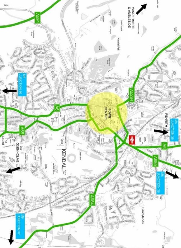

Mott MacDonald | Kendal Northern Access Route
Strategic Outline Business Case Summary

Document reference: 374182 | 5 | D

Information class: Standard

 This document is issued for the party which commissioned it and for specific purposes connected with the above-
 captioned project only. It should not be relied upon by any other party or used for any other purpose.

 We accept no responsibility for the consequences of this document being relied upon by any other party, or being
 used for any other purpose, or containing any error or omission which is due to an error or omission in data supplied
 to us by other parties.

 This document contains confidential information and proprietary intellectual property. It should not be shown to other
 parties without consent from us and from the party which commissioned it.
 This R eport has been prepar ed sol el y for us e by the party which commissi oned it (the 'Client') in connection wi th the capti oned pr oject. It shoul d not be used for any other purpose. N o pers on other than the Client or any party who has expr essl y agreed terms of reli ance with us (the 'Recipi ent(s)') may r el y on the content, infor mation or any views expr ess ed in the R eport. T his R eport is confi denti al and c ontains pr opri etary intell ectual pr op erty and we ac cept no duty of car e, r esponsibility or li ability to any other recipi ent of this R eport. N o repr esentati on, war ranty or undertaki ng, express or i mplied, is made and no res ponsi bility or liability is ac cepted by us to any party other than the Client or any Reci pient(s), as to the acc urac y or completeness of the i nfor mati on c ontai ned i n this R eport. F or the avoi danc e of doubt thi s Report does not i n any way pur port to i nclude any legal, ins uranc e or fi nanci al advic e or opi nion.

 We dis clai m all and any liability whether arising i n tort, contr act or other wis e which we might otherwis e have to any party o ther than the Cli ent or the Reci pient(s), in res pect of this Report, or any infor mation contained in it. We acc ept no res ponsi bility for any error or omissi on in the Report which is due to an error or omissi on in data, i nfor mation or statements s upplied to us by other parti es i ncludi ng the Cli ent (the 'Data'). We have not independentl y verified the D ata or other wis e exami ned i t to deter mi ne the acc ura c y, completeness, sufficienc y for any purpose or feasi bility for any partic ular outc ome incl uding fi nanci al.

 Forec asts pres ented i n this document were pr epared usi ng the Data and the Repor t is dependent or bas ed on the D ata. Inevitabl y, s ome of the ass umptions us ed to develop the for ecasts will not be realised and unantici pated events and circumstanc es may occ ur. C onsequentl y, we do not guarantee or warrant the conclusions c ontained in the R eport as ther e are li kel y to be differenc es between the forecas ts and the actual res ults and those differ ences may be material. While we c onsi der that the infor mation and opini ons given in thi s R eport are s ound all parti es must rel y on their own s kill and judgement when making us e of it.

 Infor mation and opi nions ar e c urrent onl y as of the date of the Report and we acc ept no res ponsi bility for updati ng such infor mation or opi nion. It s houl d, therefor e, not be assumed that any s uc h infor mati on or opi nion conti nues to be acc urate subs equent to the date of the Report. U nder n o circumstanc es may this Report or any extrac t or summar y thereof be us ed i n c onnecti on with any public or pri vate s ec urities offeri ng incl udi ng any related memor andum or pr os pec tus for any securiti es offering or stoc k exchange listi ng or announcement.

 By acc eptanc e of this Repor t you agree to be bound by this disclai mer. T his disclai mer and any iss ues, dis putes or cl ai ms arising out of or in c onnection wi th it ( whether c ontractual or non-contractual i n natur e s uc h as cl ai ms i n tort, from br eac h of statute or regul ati on or otherwis e) s hall be governed by, and co nstr ued i n acc ordance with, the laws of Engl and and Wales to the exclusion of all c onflict of l aws principles and r ules . All dis putes or clai ms arising out of or r elati ng to this discl ai mer s hall be s ubjec t to the excl usi ve juris dicti on of the English and Welsh courts to which the parties irrevocabl y submit.

374182 | 5 | D | June 2018
P:\Liverpool\ITD\Projects\374182 Kendal STI Study\Phase 5_Extension_SOBC Summary\Rev D Final\Kendal NAR_SOBC Summary_RevD_FINAL.docx

Mott MacDonald | Kendal Northern Access Route
Strategic Outline Business Case Summary

Contents

Executive Summary                                                                                                   1

1       Introduction                                                                                                3

2       Strategic Fit                                                                                               6

3       Economic Appraisal                                                                                        17

4       Next Steps                                                                                                20

Appendices                                                                                                        23

A.      Kendal Northern Access Route – indicative alignment                                                       24

B.      M6 Emergency Diversion Route                                                                              25

C.      Kendal Town Centre Gyratory                                                                               26

D.      Kendal Local Accessibility Context                                                                        27

374182 | 5 | D | June 2018
P:\Liverpool\ITD\Projects\374182 Kendal STI Study\Phase 5_Extension_SOBC Summary\Rev D Final\Kendal NAR_SOBC Summary_RevD_FINAL.docx

Mott MacDonald | Kendal Northern Access Route                                                                                          1
Strategic Outline Business Case Summary

Executive Summary

This document presents a summary Strategic Outline Business Case (SOBC) for the Kendal
Northern Access Route. The Kendal Northern Access Route is a prospective corridor to the
north of Kendal, which will provide congestion relief and air quality improvements in Kendal
town centre; provide a suitable diversion route for the M6 at times when the M6 is closed; and
support economic development and growth in Kendal. This summary SOBC demonstrates the
case for investment in the Kendal Northern Access Route, and provides the basis for more
detailed development work on the scheme.

The Kendal Strategic Transport Infrastructure Study
This summary SOBC forms the outcome of the Kendal Strategic Transport Infrastructure Study,
which was commissioned by Cumbria County Council in partnership with South Lakeland
District Council and Kendal Town Council.

The aim of the Kendal Strategic Transport Infrastructure Study was to examine options for
strategic transport improvements, and to demonstrate the case for investment in a preferred
transport scheme. The primary objectives to guide the study were as follows:

1. Deliver the future strategic growth of the town.
2. Reduce congestion and increase network resilience within the town centre.
3. Improve the resilience of Kendal’s transport network so that connectivity is retained during
   potential future flood events.
4. Improve resilience and accessibility to existing employment areas.
5. Ensure that, when the M6 is closed, diverted traffic is not reliant on single-lane bridges in
   Kendal therefore improving the resilience of the M6 corridor in the Kendal area.

The Kendal Northern Access Route
The Kendal Northern Access Route is the preferred option that has emerged from the Strategic
Transport Infrastructure Study. The prospective route corridor runs across the north of Kendal,
from Plumgarths Roundabout on the A591 in the west, to the A6 in the east, with potential for
further connectivity to the A685.

An illustration of the indicative alignment for the Northern Access Route is included in Appendix
A to this report.

Key benefits for Kendal and Cumbria
The key benefits of the Kendal Northern Access Route are as follows:

● A significant reduction in congestion and improvements in air quality in Kendal town
  centre, by taking traffic out of the congested A6 and town centre gyratory.
● Significant journey time savings for road users. Indicative economic appraisal, using the
  Kendal Transport Model, has shown that the journey time savings from the Northern Access
  Route would exceed £110m.
● Improved network resilience, both for Kendal and the wider M6 corridor, when the
  Emergency Diversion Route (EDR) is activated. The Northern Access Route would link

374182 | 5 | D | June 2018
P:\Liverpool\ITD\Projects\374182 Kendal STI Study\Phase 5_Extension_SOBC Summary\Rev D Final\Kendal NAR_SOBC Summary_RevD_FINAL.docx

Mott MacDonald | Kendal Northern Access Route                                                                                          2
Strategic Outline Business Case Summary

    the A6 north of Kendal directly with the A591, avoiding the need for M6 traffic to travel
    through the town centre.
● Unlocking economic development and growth in Kendal, by connecting potential
  development sites to the north of Kendal with the strategic road network.
● Increasing accessibility for residents and businesses, particularly businesses along the
  Shap Road corridor.
● An additional crossing over the River Kent, providing greater resilience and enabling
  Kendal to retain a good level of transport connectivity during potential future flood events.

How the preferred scheme has been identified
The Strategic Transport Infrastructure Study followed a structured options appraisal process to
identify a preferred option, as shown below.

Figure 1: Options appraisal process

                                                                             Development
             Identify                                  Appraisal of
                                 Generation of                               of shortlisted
          issues, scope                                 long list to                                 Preferred
                                 options long                                schemes for
           and scheme                                     identify                                    option
                                      list                                       further
            objectives                                    shortlist
                                                                             assessment

In total, eight options were considered at the long list stage, and four options were shortlisted for
further assessment, leading to the selection of the Kendal Northern Access Route as the
preferred option. The Strategic Fit (Section 2 of this document) and the Economic Appraisal
(Section 3) provide a more detailed overview of each stage within the decision-making process.

Next steps
This summary SOBC demonstrates the case for investment in the Kendal Northern Access
Route at a high level. The SOBC is the first stage in the process of preparing the transport
business case for the scheme, and will need to be followed by a more detailed Outline Business
Case and full Major Scheme Business Case. The development of the case is evidence driven
and necessitates the coordination of a range of issues including congestion, growth,
environmental quality, waste management, deliverability and ultimately value for money.

374182 | 5 | D | June 2018
P:\Liverpool\ITD\Projects\374182 Kendal STI Study\Phase 5_Extension_SOBC Summary\Rev D Final\Kendal NAR_SOBC Summary_RevD_FINAL.docx
Mott MacDonald | Kendal Northern Access Route                                                                                          3
Strategic Outline Business Case Summary

1 Introduction

The Kendal Strategic Transport Infrastructure Study was commissioned by Cumbria County
Council (CCC) in August 2016, in partnership with South Lakeland District Council (SLDC) and
Kendal Town Council (KTC) to investigate the feasibility of strategic transport improvements in
Kendal. This report summarises the Strategic Outline Business Case (SOBC) for the preferred
option identified in the study, the Kendal Northern Access Route.

1.1      Strategic Need
The need for investment in strategic transport infrastructure and key contextual issues in Kendal
are defined as:

● Strategic Access:
    – When the M6 Emergency Diversion Route (EDR) is activated, diverted traffic adds to
      congestion within Kendal.
    – There is a lack of route choice for HGVs accessing industrial areas to the north of the
      town centre from the south of the town, increasing through-traffic levels in the town
      centre.
    – The hilly topography surrounding Kendal necessitates that principal routes serving
      Kendal have a number of sharp bends and steep sections of carriageway, adversely
      impacting on the safety of these routes and their suitability to carry large volumes of
      traffic.
● Local Access:
    – Narrow, low capacity streets in Kendal town centre increase both levels of congestion and
      journey times.
    – There is no direct through route for north-south movements.
    – Victoria Bridge is the only river crossing within the town that supports west-to-east
      movements.
● Economic Development and Growth:
    – There is a need to support the future growth of Kendal including for new well connected
      housing and employment land.
    – Many employment sites are constrained by poor road access.
● Environment:
    – Routes in the north of the town centre became impassable to traffic after Storm Desmond
      and future flooding could again cause road closures, diversions and congestion.
    – Infrastructure to enable cars, buses and HGVs to avoid routing via Lowther Street could
      offer significant air quality benefits in an area where levels of nitrogen dioxide are
      currently failing to meet government targets.

1.2      Scheme Objectives
The objectives for investment in enhanced strategic transport infrastructure for Kendal were
therefore defined as follows:

1. Deliver the future strategic growth of the town and ensure that high levels of growth and
   investment can be achieved across Kendal.

374182 | 5 | D | June 2018
P:\Liverpool\ITD\Projects\374182 Kendal STI Study\Phase 5_Extension_SOBC Summary\Rev D Final\Kendal NAR_SOBC Summary_RevD_FINAL.docx
Mott MacDonald | Kendal Northern Access Route                                                                                          4
Strategic Outline Business Case Summary

2. Reduce levels of through traffic and congestion within Kendal town centre.
3. Improve the resilience of Kendal’s transport network so that connectivity to, from and within
   the town is retained during potential future flood events.
4. Improve accessibility to existing as well as proposed employment areas.
5. Enhance the resilience of the M6 corridor in the Kendal area, so that traffic is not reliant on
   single lane bridges and narrow town centre streets through Kendal when the M6 EDR is
   activated.

1.3      Proposed Scheme
A total of four scheme options and a ‘Do Minimum’ option have been assessed.

Assessments demonstrated that the Northern Access Route, a proposed new link road to the
north of Kendal, from Plumgarths Roundabout on the A591 in the west, to the A6 in the east
would be the preferred option. This would also have the potential for further connectivity to the
A685. The options appraisal undertaken as part of the Strategic Transport Infrastructure Study
has demonstrated that this option meets all of the objectives, and delivers the greatest benefits
for Kendal and Cumbria.

An illustration of the indicative alignment for the Northern Access Route is included in Appendix
A to this report.

1.4      Scheme Benefits
The Northern Access Route will meet the fundamental objectives of the study including
delivering future strategic growth in Kendal and improving access to current and future
employment sites, reducing town centre congestion and improving the resilience for both Kendal
and the wider M6 corridor when the Emergency Diversion Route (EDR) is activated. It will
connect potential development sites to the north of Kendal with the strategic road network south
of Burneside. Delivery of the route can also support the future growth of Kendal and the
development of the next South Lakeland District Local Plan.

The route will directly link the A591 to the A6, and potentially onwards to the A685, improving
strategic access to and from Kendal, in addition to providing an additional crossing of the River
Kent. Accessibility to existing businesses at Mintsfeet and within the Shap Road corridor will be
significantly improved, in addition to enhanced accessibility between Windermere and
Ambleside to the M6.

The likely transport benefits of the scheme were assessed using the Kendal Transport Model, a
SATURN model held by Cumbria County Council. Network journey time has been monetised to
provide an estimate of the journey time benefits for the scheme. Under the 2036 Base scenario,
the Northern Access Route provides monetised transport benefits of £112.2m; under the 2036
growth scenario, this increases to £531.6m. Further information on the quantitative benefits of
the scheme are outlined within the Economic Appraisal (Section 3 of this report).

By providing an additional crossing of the River Kent, there are also opportunities to engineer
the new route so that it contributes to flood water storage, helping to reduce the scale of the
impacts of potential future flood events.

1.5      How to read this document
This SOBC summary document is based on the Department for Transport’s (DfT’s) guidance on
the preparation of Transport Business Cases. The remainder of this document is structured as
follows:

374182 | 5 | D | June 2018
P:\Liverpool\ITD\Projects\374182 Kendal STI Study\Phase 5_Extension_SOBC Summary\Rev D Final\Kendal NAR_SOBC Summary_RevD_FINAL.docx
Mott MacDonald | Kendal Northern Access Route                                                                                          5
Strategic Outline Business Case Summary

● Section 2: Strategic Fit shows that the Kendal Northern Access Route is supported by a
  robust case for change that fits with wider public policy objectives.
● Section 3: Economic Appraisal demonstrates that the Kendal Northern Access Route
  would deliver value for money.
● Section 4: Next Steps discusses the next steps for the Kendal Northern Access Route,
  including further coordination with the Local Plan process, and further work to show that the
  proposed scheme is achievable, commercially viable and financially affordable.

374182 | 5 | D | June 2018
P:\Liverpool\ITD\Projects\374182 Kendal STI Study\Phase 5_Extension_SOBC Summary\Rev D Final\Kendal NAR_SOBC Summary_RevD_FINAL.docx
Mott MacDonald | Kendal Northern Access Route                                                                                          6
Strategic Outline Business Case Summary

2 Strategic Fit

This Strategic Fit analyses the key local transport network issues in Kendal, as well as wider
development pressures and environmental issues. It reflects upon the role that improved
strategic transport infrastructure can play in delivering local, regional and national aspirations,
ranging from improved flood resilience at the local level, to improved strategic routing when the
M6 is closed at the national level. Collated evidence has been used to generate a total of 8
investment options and drive an initial assessment to arrive at a shortlist of 4 options. The
Economic Appraisal that follows this chapter outlines how the preferred option has been
selected from this shortlist of 4 options.

2.1         Background
Kendal is the largest settlement within South Lakeland, with a population in excess of 28,000,
equating to around 40% of the district’s total population. The town is located on the south-east
border of the Lake District National Park and both the M6 and West Coast Mainline railway are
located in close proximity to the town. These link Kendal to regional and national destinations.
Kendal’s position within the valley of the River Kent as well as the historic character of the town
centre afford the town a highly attractive setting, supporting a strong visitor offer.

The town is a significant attractor of people from across the South Lakeland District and beyond,
serving as the district’s principal retail and employment destination. The town supports a wide
range of retail, financial and professional service jobs as well as major advanced manufacturing
and warehousing, particularly to the north of the town in the Shap Road corridor including
Lakeland Limited in the Westmorland Business Park and the James Cropper PLC site at
Burneside.

2.2         The Need for Investment
This section outlines the need for investment in improved strategic transport infrastructure for
Kendal through analysis of both current and forecast challenges and opportunities relating to
environmental contexts, strategic infrastructure and wider economic and social impacts.

2.2.1            Flooding
The impacts of Storm Desmond (which occured in the first week of December 2015) in Kendal
served as a key catalyst for a study into Kendal’s strategic transport infrastructure. Flooding
associated with the event was the largest ever to be recorded in Kendal, with over 2,000 homes
and premises affected by flood water 1. The flood event led to a number of key routes in the town
centre becoming impassable to traffic including the A6 Shap Road (Figure 2) and the A685
Appleby Road (Figure 3), with flood depth reaching 1.2m above the surface of the carriageway.

Victoria Bridge, the only town centre bridge which supports cross river movement from west to
east was also subject to ongoinig closures and restrictions for over 3 months between early
December and early March, signficantly reducing town centre network resilience. In addition to
town centre closures, the A591 was also closed to traffic between Kendal and the Brettargh Holt
roundabout, reducing strategic connectivity between Kendal and the M6 and increasing traffic
demand and congestion on the A65 corridor through Oxenholme.

1
    Environment Agency (2016) Flood Investigation Report: Flood Event 5th-6th December. Available at:
      http://www.cumbria.gov.uk/eLibrary/Content/Internet/536/6181/42557103755.pdf

374182 | 5 | D | June 2018
P:\Liverpool\ITD\Projects\374182 Kendal STI Study\Phase 5_Extension_SOBC Summary\Rev D Final\Kendal NAR_SOBC Summary_RevD_FINAL.docx
Mott MacDonald | Kendal Northern Access Route 7 Strategic Outline Business Case Summary Figure 2: Impact of Storm Desmond Figure 3: Impact of Storm Desmond flooding at Shap Road flooding at the A685 and across Kendal Source: Mercury Press (2015) Source: Mercury Press (2015) Following Storm Desmond, Cumbria County Council and partners began considering the role the local highway network could play in mitigating the impact of future flooding events. Investment in a scheme to provide an east-west bypass of Kendal town centre away from the floodplain would provide further route choice for vehicles in the Kendal area and add further resilience to the network in the event of further major flood events. 2.2.2 Strategic Access An overview of key routes to and from Kendal town centre is indicated in Figure 4. Junction 36 of the M6 is accessed within a 15-minute drive to the south-east of Kendal town centre via the A6, A591 and A590. Figure 4: Kendal Strategic Access Routes Source: Mott MacDonald 374182 | 5 | D | June 2018 P:\Liverpool\ITD\Projects\374182 Kendal STI Study\Phase 5_Extension_SOBC Summary\Rev D Final\Kendal NAR_SOBC Summary_RevD_FINAL.docx
Mott MacDonald | Kendal Northern Access Route                                                                                          8
Strategic Outline Business Case Summary

The hilly topography surounding Kendal means many of the principal ‘A’ routes to and from
Kendal have a numebr of sharp bends and steep sections of carriageway, adversely impacting
upon the safety of these routes and their suitability to carry large volumes of traffic.

Outside of Wales, Cumbria has the highest proportion of all road casualties in the 17-19 age
group in the UK at 15.8%, indicating that the network in the area is particularly unsuited to
inexperienced drivers2. This reinforces safety concerns on key routes to and from Kendal and
on the wider Cumbrian network, highlighting the urgent need for investment to deliver safer
routes.

2.2.2.1             HGV Routes
CCC have published a series of HGV Network Maps for Cumbria3. These routes aim to reduce
disruption or delay on the highway network, but are directed through Kendal town centre. The
unsuitability of Kendal’s local road network to take HGVs is increasing town centre traffic levels
and reducing accessibility for residents and businesses. High volumes of HGVs in the town
reduce the attractiveness of walking and cycling, increasing the propensity for users to travel by
car in the town, which in turn adds to network congestion.

Future investment in improved access between key business and employment sites at Mintsfeet
and the Strategic Highway Network at the M6 will ensure that Kendal remains attractive for
existing and potential businesses, supporting growth and employment within the town.

2.2.2.2             M6 Emergency Diversion Route (EDR)
When a major incident occurs on the M6 and the north and/or southbound carriageway is shut
between Junctions 36-39, the Emergency Diversion Route (EDR) is activated. Motorway traffic
is then routed through Kendal town centre, as shown in Appendix B. The suitability of the route
to carry high volumes of traffic is reduced by the speed restrictions, steep gradients and bends
along the route.

When activated, the EDR worsens town centre journey times and increases air pollution levels
in the area. Increased traffic significantly reduces network resilience in the Kendal area, having
a detrimental effect on accessibility to the town centre. The objectives for new strategic
transport infrastructure for Kendal should therefore consider how investment could be used to
avoid the need for through and diverted motorway traffic to be routed through Kendal town
centre, helping to improve journey times for through traffic as well as for vehicles completing
regular journeys within the town.

2.2.3            Local Access
As indicated in Appendix C, Kendal town centre is characterised by a number of narrow one-
way streets. For vehicles bound for the town centre from the south of the town, the A6
Milnthorpe Road and A65 Burton Road converge at Nether Bridge, as shown in Appendix D.
The A65 also provides the principal connection between Kendal town centre and Westmorland
General Hospital and Oxenholme. No direct through route for north-south movements is
available through Kendal along the A6 due to the semi-pedestrianisation of the high street.

2
    RAC Foundation (2016) Road Safety. Available at: http://www.racfoundation.org/motoring-faqs/safety#a11
3
    Cumbria County Council (2010) HGV Guide. Available at: http://www.cumbria.gov.uk/roads-transport/public-transport-road-
      safety/transport/hgv/hgv.asp

374182 | 5 | D | June 2018
P:\Liverpool\ITD\Projects\374182 Kendal STI Study\Phase 5_Extension_SOBC Summary\Rev D Final\Kendal NAR_SOBC Summary_RevD_FINAL.docx
Mott MacDonald | Kendal Northern Access Route 9 Strategic Outline Business Case Summary 2.2.3.1 Congestion As highlighted within the Cumbria Transport Plan Strategy 2011-2026, Kendal suffers from regular localised traffic congestion and a strategic priority at both county and district level is to overcome the adverse effects of this congestion on the economy and environment of the town. Congestion increases levels of poor air quality within the town, decreasing the attractiveness of walking and cycling, further enforcing high levels of car use and congestion within Kendal. A review of traffic data from Google Maps’ traffic interface demonstrates that the town centre road network suffers from congestion throughout the day on a typical weekday as well as at the weekend, as shown in Figure 5 and Figure 6. The orange and red routes demonstrate congested routes, with uncongested routes highlighted in green. Figure 5: Typical weekday peak congestion Figure 6: Typical weekend peak congestion levels (9AM) levels (12PM) Source: Google Maps Source: Google Maps Transport modelling assessments completed by Cumbria County Council have also highlighted that a number of junctions within the town centre are currently operating over capacity, with further junctions forecast to be operating over capacity by 2022 if committed developments and Local Plan proposals in Kendal, Burneside, Natland and Oxenholme are brought forward as expected. The modelling assessments have made use of the Kendal Transport (SATURN) model and assumes that modelled junctions with an RFC (Ratio of Flow to Capacity) greater or equal to 90% have limited capacity and are congested. Without long-term investment in Kendal’s highway network to help relieve town centre congestion, and thus make the town centre a more attractive and viable retail destination for both businesses and shoppers, the town will struggle to support economic growth and new employment. 2.2.3.2 Victoria Bridge Victoria Bridge is the only bridge within Kendal that supports west to east movements over the River Kent for vehicles within the town centre and it therefore provides a crucial link from Kendal town centre towards the rail station, employment areas to the north of the town and the M6. The impacts of Storm Desmond led to the closure of the bridge for a month across January and February 2016, adding to local congestion levels and reducing connectivity for all town centre 374182 | 5 | D | June 2018 P:\Liverpool\ITD\Projects\374182 Kendal STI Study\Phase 5_Extension_SOBC Summary\Rev D Final\Kendal NAR_SOBC Summary_RevD_FINAL.docx
Mott MacDonald | Kendal Northern Access Route                                                                                            10
Strategic Outline Business Case Summary

vehicle users. Options for strategic transport improvements for Kendal should therefore consider
the viability of providing new river crossings to help improve the resilience of the town centre
transport network in the event of major flood events.

2.2.3.3              Travel to Work
Kendal has a population density of 1,855 people/km2. The town is a key trip attractor on the M6
corridor through the county, with over 1,000 journeys to work made to the town every day4. In
order to better support commuter movements to Kendal and stimulate economic and job growth
in the area, enhancing strategic transport network will bring clear benefit. Without this
investment, given the existing traffic and congestion issues within Kendal, the town centre will
be an unattractive location for potential new investors bringing further economic prosperity and
jobs to the town.

2.2.4            Air Quality
An Air Quality Management Area (AQMA) was declared for Kendal in 2000 when levels of
nitrogen dioxide (NO2) at Lowther Street were found to be above the government’s annual mean
objective for the pollutant. This was extended in 2010 to cover additional roads in the town
centre.

As noted within South Lakeland’s most recent Air Quality Annual Status Report, levels of NO2 at
Lowther Street still fail to meet government objectives 5. To improve environmental quality at
Lowther Street, investment in strategic transport infrastructure to remove the need for
northbound through traffic to travel through the town centre should be delivered. This will also
help to increase the safety and desirability of the area, and help promote Kendal as an attractive
location for investment.

2.2.5            Economic Development and Growth
The population in Kendal is growing at a faster rate than for South Lakeland and Cumbria as a
whole. Growth has been notable in the arts, recreation and health sectors. SLDC’s Core
Strategy for Kendal certifies the aim to:

● Make provision for 3,080 new residential dwellings between 2003 and 2025, prioritising
  previously developed land and sites within urban areas.
● Accommodate in the region of 21 hectares of employment land between 2010 and 2025.
To enable proposed development to come forward, further investment in Kendal’s transport
network is crucial. This will support long-term economic growth and employment opportunities,
overcoming high levels of congestion within the town centre, and a relative lack of connectivity
to potential development sites outside of the town centre.

2.2.5.1              Land Allocations
The South Lakeland Local Plan Land Allocations: Development Plan Document (DPD) allocates
land within the district for housing, employment, mixed-use and other uses, certifying the aim to

4
    Cumbria LEP (2015) West of M6 Strategic Connectivity Study: Option Appraisal Report. Available at: http://www.cumbrialep.co.uk/wp-
      content/uploads/2015/09/West-of-M6-Strategic-Connectivity-Study-Report_FINAL2.pdf
5
    South Lakeland District Council (2016) 2016 Air Quality Annual Status Report (ASR). Available at:
      http://www.southlakeland.gov.uk/EasySiteWeb/GatewayLink.aspx?alId=55031

374182 | 5 | D | June 2018
P:\Liverpool\ITD\Projects\374182 Kendal STI Study\Phase 5_Extension_SOBC Summary\Rev D Final\Kendal NAR_SOBC Summary_RevD_FINAL.docx
Mott MacDonald | Kendal Northern Access Route 11
Strategic Outline Business Case Summary
accommodate around 60% of South Lakeland’s new homes and workplaces in Kendal and the
surrounding area6.
As of 2013 when the Land Allocations were adopted, 2,373 dwellings are proposed in Kendal to
meet a District wide requirement of 6,756 between 2013 and 2025. In order to meet this
contribution, by 2025, an average of 215 dwellings will need to be delivered per annum, a rate
of growth which far exceeds the 171 p/a growth in new dwellings achieved between 1991 and
2009. However, as noted within the DPD, Kendal is the key area within the district where
existing infrastructure is under stress and “particular areas of stress are the town centre
transport network, which is suffering significant congestion at peak times”.
It is therefore clear that strategic transport infrastructure improvements for Kendal, in order to
deliver both improvements to the town centre network as well as to the network surrounding the
town will be required to deliver both residential and employment growth at key sites within
Kendal.
2.2.5.2 Growth beyond the current Local Plan Period
The next SLDC Local Plan will supersede the current Core Strategy and is scheduled for
adoption by July 2021. It is intended to cover the period 2021-2036. This will need to consider a
range of growth opportunities which will impact on transport networks within the town. To
support this stage of development work a number of assumptions were made. These will require
further consideration through development of the next Local Plan.
2.3 Policy and Strategy Context
This section of the Strategic Fit shows how investment in strategic transport infrastructure in
Kendal aligns with wider policies and strategies at national, regional and local level.
2.3.1 Kendal and the Northern Powerhouse
The Northern Powerhouse represents the shared vision of the Government, Northern city
regions and Local Enterprise Partnerships for “joining up the North’s great towns, cities and
counties, pooling their strengths, and tackling major barriers to productivity to unleash the full
economic potential of the North”, as highlighted within Transport for the North’s (TfN’s) Draft
Strategic Transport Plan7.
TfN’s Draft Strategic Transport Plan has identified seven ‘Strategic Development Corridors’,
which represent economic areas where TfN’s evidence to date suggests most progress towards
transformational growth would be made by bringing forward major, strategic rail and road
investment. One of the seven Strategic Development Corridors identified by TfN is ‘Connecting
the Energy Coasts’, which aims to improve connectivity for people and goods between the
nationally significant non-carbon energy and research assets located in Cumbria, Lancashire,
North Yorkshire, the North East, and Tees Valley (Figure 7).
6
South Lakeland District Council (2013) South Lakeland Local Plan Land Allocations: Development Plan Document. Available at:
http://applications.southlakeland.gov.uk/documentbrowser/DocumentBrowserFiles/local%20plan/land%20allocations/00%20Adoptio
n/01%20Local%20Plan%20-%20Land%20Allocations%20Adopted%20Dec%202013.pdf
7
Transport for the North (2018), Draft Strategic Transport Plan. Available at: https://transportforthenorth.com/stp/
374182 | 5 | D | June 2018
P:\Liverpool\ITD\Projects\374182 Kendal STI Study\Phase 5_Extension_SOBC Summary\Rev D Final\Kendal NAR_SOBC Summary_RevD_FINAL.docxMott MacDonald | Kendal Northern Access Route 12
Strategic Outline Business Case Summary
Figure 7: The ‘Connecting the Energy Coasts’ Strategic Development Corridor
Source: Transport for the North (2018), Draft Strategic Transport Plan
Investment in improved strategic connectivity for Kendal will help deliver a step change in
strategic access for businesses and residents in the North West who are reliant on the
connectivity provided by the M6, and could form a crucial component of the future strategy for
the ‘Connecting the Energy Coasts’ corridor.
2.3.2 Cumbria Local Enterprise Partnership (LEP)
The Cumbria Local Enterprise Partnership (LEP) is one of the UK’s 39 LEPs. As outlined within
the ‘Four Pronged Attack’ Strategic Economic Plan (SEP), the vision for the Cumbria LEP is to
unleash Cumbria’s full economic potential and make a significant contribution to UK growth 8.
Improved strategic connectivity in the Kendal area would support the four priority themes of the
Cumbria LEP, as shown in Figure 8 below:
● Advanced manufacturing growth: The SEP highlights that a number of potential
employment sites in the M6 corridor, including at Kendal, could be brought forward if
investment in enhanced strategic transport infrastructure is delivered.
8
Cumbria LEP (2014) The Four Pronged Attack: Cumbria Strategic Economic Plan 2014-2024. Available at:
http://www.cumbrialep.co.uk/wp-content/uploads/2014/03/Cumbria-LEP-final-report-1-April-2014.pdf
374182 | 5 | D | June 2018
P:\Liverpool\ITD\Projects\374182 Kendal STI Study\Phase 5_Extension_SOBC Summary\Rev D Final\Kendal NAR_SOBC Summary_RevD_FINAL.docxMott MacDonald | Kendal Northern Access Route 13
Strategic Outline Business Case Summary
● Nuclear and energy excellence: Improvements to strategic connectivity in Kendal will also
support access to nationally significant nuclear and energy opportunities on the Cumbrian
Coast including the proposed Moorside nuclear new build and ongoing decommissioning at
Sellafield.
● Vibrant rural and visitor economy: Kendal’s attractive town centre streets and buildings,
the Kendal Castle, Brewery Arts Centre and the Kendal Museum contribute to Kendal’s
significant visitor offer and the improved access to and from the town that would be afforded
by investment in strategic infrastructure will further stimulate Kendal’s visitor economy.
● Strategic connectivity of the M6 corridor: Investment in strategic transport infrastructure
in Kendal would create a much more reliable and resilient Emergency Diversion Route.
Figure 8: Cumbria LEP Priority Themes
Source: Cumbria LEP (2014)
2.4 Strategic Scenario Development
Using the issues and opportunities identified in Section 2.2, a number of potential strategic
scenarios were developed by the Kendal Strategic Transport Infrastructure Study team as well
as elected members and officers from CCC, SLDC and KTC during formal consultation
workshop events. The scenarios were developed to enable the members and officers to identify
both their aspirations for strategic transport infrastructure in Kendal and potential investment
options. There was agreement from members and officers consulted that a total of seven
strategic scenarios should be tested using transport appraisal tools in the next phase of the
study:
1. Flood Resilience.
2. Strategic Connectivity.
3. Town Centre.
374182 | 5 | D | June 2018
P:\Liverpool\ITD\Projects\374182 Kendal STI Study\Phase 5_Extension_SOBC Summary\Rev D Final\Kendal NAR_SOBC Summary_RevD_FINAL.docxMott MacDonald | Kendal Northern Access Route 14
Strategic Outline Business Case Summary
4. Sustainable Access.
5. Development Support.
6. Strategic Transport & Development Support (Combined 2 & 5).
7. Strategic Sustainable Development (Combined 4 & 6).
Following use of the transport appraisal tools, the ‘Strategic Transport & Development Support’
infrastructure development scenario was identified as the preferred development scenario
against which transport infrastructure options for Kendal should align.
In order for this scenario to be successfully realised, through traffic in Kendal would be reduced
and access between Kendal and surrounding areas would be improved, with high levels of
growth and investment achieved in the area. The objectives of this scenario directly align to the
issues identified under the strategic access, local access and economic development and
growth headings and will also contribute to overcoming identified environmental issues by
reducing the need for through traffic to travel through the town centre, helping to reduce issues
of poor town centre air quality.
2.5 Scheme Objectives
The objectives for investment in a scheme to enhance strategic transport infrastructure for
Kendal were derived using both the issues and opportunities identified within Section 2.2 and
the objectives of the Strategic Transport & Development Support scenario, as discussed in
Section 2.4 above.
The resulting objectives are as follows:
1. Deliver the future strategic growth of the town and ensure that high levels of growth and
investment can be achieved across Kendal.
2. Reduce levels of through traffic and congestion within Kendal town centre.
3. Improve the resilience of Kendal’s transport network so that connectivity to, from and within
the town is retained during potential future flood events.
4. Improve accessibility to existing as well as proposed employment areas.
5. Enhance the resilience of the M6 corridor in the Kendal area, so that traffic is not reliant on
single lane bridges and narrow town centre streets through Kendal when the M6 EDR is
activated.
2.6 The Emerging Scheme
2.6.1 Options Identification
Based upon the objectives agreed for the scheme, a range of scheme options was developed
by the study team. Initial options development was undertaken by Mott MacDonald in October
2016 based on two separate workshops held with Officer and Member groups from CCC, SLDC
and KTC.
Wider stakeholders included the Environment Agency, currently undertaking extensive flood
repair work in Kendal, as well as AECOM, who are completing a Master Plan for Kendal town
centre. A total of 8 options were initially identified in this consultation, with the name and a brief
overview of each of the options shown below.
374182 | 5 | D | June 2018
P:\Liverpool\ITD\Projects\374182 Kendal STI Study\Phase 5_Extension_SOBC Summary\Rev D Final\Kendal NAR_SOBC Summary_RevD_FINAL.docxMott MacDonald | Kendal Northern Access Route 15
Strategic Outline Business Case Summary
1. Northern Access Route • Link between the A591 and A685 south of Burneside
2. Northern Orbital Access • Link between the A591 and A685 north of Burneside
Route
3. Eastern Orbtial Access • Link between A6 at Queen Katherines Avenue to the A65 at
Route 1 Helm Lane
4. Eastern Orbital Access • Link betweek the A6 at Queen Katherines Avenue to the A65 at
Route 2 Low Barrows Green/A590
5. Southern Orbital Access • Link between A591/A6 junction and the A65 Low Barrow Road,
Route 1 north of Natland
6. Southern Orbital Access • Link between the A590/A591 junction and the A65 Low Barrow
Route 2 Road, south of Natland
7. Western Town Centre • Link between A591 in the vicinity of Brigsteer Road and Highgate
Access Route in the vicinity of Beast Banks
• New or wider bridges at Lound Road and Aynam Road to
8. Cross River Access facilitate a change in the gyratory to the south of the town centre
2.6.2 Initial Assessment
The Investment Sifting and Evaluation Tool (INSET) has been used by the study team to
undertake an initial assessment of each of the 8 scheme options. Mott MacDonald has
developed INSET as an enhancement of DfT’s EAST (Early Assessment and Sifting Tool) to
support the evaluation of different options for large-scale investments and investment
programmes.
2.6.2.1 Assessment Process
To structure the process, the INSET assessment asked a series of questions based around four
key themes:
● A - Overview (quality of information) that was available for the proposed intervention.
● B - Option length (proxy for cost) that assigned the approximate route length for each of the
proposed schemes, to gauge an early understanding of cost.
● C - Benefits that the proposed interventions would be expected to deliver across; transport,
wider economic, social and environmental.
● D – Deliverability of the proposed intervention.
In order to inform the appraisal of the scheme options using INSET and to increase
understanding of the relative benefits and deliverability of the options, discussions were held
with officers from CCC and SLDC in January 2017.
2.6.2.2 Appraisal Results
An overview of the results of the completed INSET appraisal process, with the results for each
of the schemes against the four themes, is displayed in Figure 9.
374182 | 5 | D | June 2018
P:\Liverpool\ITD\Projects\374182 Kendal STI Study\Phase 5_Extension_SOBC Summary\Rev D Final\Kendal NAR_SOBC Summary_RevD_FINAL.docxMott MacDonald | Kendal Northern Access Route 16
Strategic Outline Business Case Summary
Figure 9: INSET Appraisal Results: Shortlisted Options
MULTI-CRITERIA ANALYSIS - SUMMARY
D. Multi-Criteria
B. Option length C. Multi-Criteria D. Multi-Criteria Analysis (Deliverability- Total Quantiative
A. Overview of Options Analysis (Deliverability
(proxy for cost) Analysis (Benefits) Description) Score
score)
No. Name
Is enough information Deliverability Based on benefits
Final weighted score Final weighted score Dependencies on other
available to assess the Approximate length: score (low / and deliverability
(-2 to 2 scale): (0-3 scale): options:
proposed option? medium / high): criteria
Medium
1 Northern Access Route YES all options 2-3km 1.25 1.88 3.13
deliverability
Northern Orbital Access
2 YES all options 4-7km 1.11 0.75 Low deliverability 1.86
Route
Eastern Orbital Access
3 YES 5-7km 0.86 0.56 Low deliverability 1.43
Route 1
Eastern Orbital Access
4 YES all options 8-10km+ 0.91 0.38 Low deliverability 1.28
Route 2
Southern Orbital Access
5 YES all options 2-3km 1.07 2.63 High deliverability 3.70
Route 1
Southern Orbital Access
6 YES 2-3km 0.19 0.38 Low deliverability 0.57
Route 2
Western Town Centre Medium
7 YES 2-3km -0.10 1.50 1.40
Access Route deliverability
Dependant on the
outcome of the
8 Cross River Access YES N/A 0.75 2.63 High deliverability 3.38
Environmental Agency
Flood Report
Source: Mott MacDonald
A total of 4 options were subsequently shortlisted for further assessment on the highway
network using the Kendal Transport Model. This included Options 1, 5 and 8 as well as a
combined Option 9, which was included following consultation with officer and member groups:
● Option 1 – Northern Access Route.
● Option 5 – Southern Orbital Access Route 1.
● Option 8 – Cross River Access.
● Option 9 – A combined package incorporating both Option 1 and Option 8.
374182 | 5 | D | June 2018
P:\Liverpool\ITD\Projects\374182 Kendal STI Study\Phase 5_Extension_SOBC Summary\Rev D Final\Kendal NAR_SOBC Summary_RevD_FINAL.docxMott MacDonald | Kendal Northern Access Route 17 Strategic Outline Business Case Summary 3 Economic Appraisal The Economic Appraisal assesses the shortlisted options quantitatively to identify their impacts and the resulting benefits. An appraisal of the transport benefits for the four scheme options and a Do Minimum option has been carried out by Cumbria County Council using the Kendal Transport Model. This has been used to inform a further appraisal of the schemes using the INSET process, resulting in the selection of a preferred option from the shortlist of four options. 3.1 Transport Forecasting and Appraisal of the Shortlisted Options 3.1.1 Methodology The transport forecasting and appraisal of the four shortlisted options was completed by Cumbria County Council officers using the Kendal Transport Model, a strategic SATURN traffic model of the Kendal urban area and surrounding district. The model covers the morning and evening weekday peak periods of 8-9am and 5-6pm. The assessment of potential infrastructure schemes in Kendal was undertaken by creating new forecast scenarios with each of the potential schemes. The output from the model scenarios was then compared to analyse the traffic impact of the scheme. The network journey time was then monetised to provide an estimate of the journey time benefits that could be expected for each scheme. 3.1.2 Demand assumptions The forecasting has considered the future year of 2036, in line with the next potential South Lakeland Local Plan period of 2025-36. The following two modelling scenarios were assessed in SATURN: ● 2036 Base scenario. ● 2036 Local Plan scenario. The 2036 Base scenario is the reference case. It includes development which is considered more than likely to occur by 2036. The 2036 Local Plan scenario includes all developments in the 2036 Base scenario; all development sites identified within the 2012–2025 South Lakeland Local Plan; an estimate of potential development which could be included in the 2025–36 South Lakeland Local Plan; and a number of potential town centre development sites identified as part of the ongoing Kendal town centre masterplan study. 3.1.3 Results The journey time benefits for each of the proposed schemes were used as the basis for an indicative economic appraisal of transport benefits. Whilst the appraisal is limited, it forms a guide to the likely scale of the scheme benefits. The forecast demand scenarios consider a future year of 2036. A 60-year appraisal period was assumed. As only one modelled year was considered, it was assumed that the journey time benefits were constant for all years in the appraisal period. For each year in the appraisal period, the journey time benefits were monetised based on forecast values of time in 2010 prices from the TAG data book (summer 2016). 374182 | 5 | D | June 2018 P:\Liverpool\ITD\Projects\374182 Kendal STI Study\Phase 5_Extension_SOBC Summary\Rev D Final\Kendal NAR_SOBC Summary_RevD_FINAL.docx
Mott MacDonald | Kendal Northern Access Route                                                                                          18
Strategic Outline Business Case Summary

The monetised journey time benefits for each scheme compared to the Do Minimum scenario
are summarised in Table 1 and Table 2.

Table 1: Monetised journey time benefits for the 2036 Base scenario (in 2010 prices)
 Improvement                    Modelled benefits            Total modelled        Annualisation and non-                    Total
 scheme                                  per year         monetised benefits        modelled time periods              monetised
                                        (pcu-hrs)                      (£m)                        factor            benefits (£m)
 Northern Access                                 742                       £0.22                            506               £112.2
 Route
 Southern Orbital                                369                       £0.11                            506                £55.5
 Access Route 1
 Cross River Access                               56                       £0.02                            506                 £8.6
 Northern Access                                 763                       £0.23                            506               £115.5
 Route & Cross River
 Access
Source: Cumbria County Council, 2017

The results in Table 1 for the base scenario show that the Northern Access Route alongside the
Cross River Access scheme could be expected to provide the largest journey time benefits. The
journey time benefits of the southern route are around half that of the northern route. The
combined north and town option shows slightly higher journey time benefits compared to the
northern route alone.

Table 2: Monetised journey time benefits for the 2036 Local Plan scenario (in 2010 prices)
 Improvement                    Modelled benefits            Total modelled        Annualisation and non-                    Total
 scheme                                  per year         monetised benefits        modelled time periods              monetised
                                        (pcu-hrs)                      (£m)                        factor            benefits (£m)
 Northern Access                                3,502                      £1.05                            506               £531.6
 Route
 Southern Orbital                               1,603                      £0.48                            506               £243.4
 Access Route 1
 Cross River Access                              -688                     -£0.20                            506              -£101.9
 Northern Access                                3,365                      £1.01                            506               £511.4
 Route & Cross River
 Access
Source: Cumbria County Council, 2017

The results in Table 2 for the local plan scenario follow a similar pattern to the base scenario.
The results show the Northern Access Route could provide the greatest journey time benefits,
and the southern route could provide roughly half of the benefits of the northern route. The
results also show that the town centre improvements could increase journey times.

The results of the journey time benefits appraisal show that the northern route provides the
highest level of journey time benefits, and suggest that the northern route could provide high
value for money. Conversely, the results suggest that the town centre improvements as tested
would not support the objectives of the study.

3.2      Identification of Preferred Scheme
Using the results of the transport appraisal conducted by Cumbria County Council as well as the
high-level scheme costs outlined within the Strategic Fit, a further round of appraisal for the four
scheme options was conducted using INSET.

The scheme which indicated the highest calculated transport user benefits (Northern Access
Route & Cross River Access) was awarded the maximum score of 2. The other schemes were

374182 | 5 | D | June 2018
P:\Liverpool\ITD\Projects\374182 Kendal STI Study\Phase 5_Extension_SOBC Summary\Rev D Final\Kendal NAR_SOBC Summary_RevD_FINAL.docx
Mott MacDonald | Kendal Northern Access Route 19
Strategic Outline Business Case Summary
then scored as a proportion of 2, relative to the transport benefit of the scheme compared to the
highest scoring (Table 3). Assessments of the wider economic benefits of each scheme as well
as social and environmental benefits remained unchanged compared to the initial INSET
assessment for the long list of 8 options.
Table 3: Scoring of transport benefits in the final INSET assessment
Option Total monetised transport Transport benefits score
benefits (£m)
Northern Access Route £112.2 1.94
Southern Orbital Access Route 1 £55.5 0.96
Cross River Access £8.6 0.15
Northern Access Route & Cross £115.5 2.00
River Access
The final scores for each of the four options are outlined within Figure 10.
Figure 10: INSET Appraisal – Final Monetised Benefits
3. MULTI-CRITERIA ANALYSIS - SUMMARY
1B. Multi-Criteria
1A. Multi-Criteria 1B. Multi-Criteria Analysis Total Quantiative
0. Overview of Options Analysis (Deliverability 1C. Costs
Analysis (Benefits) (Deliverability- Description) Score
score)
No. Name
Is enough information Deliverability
Final score Final score Dependencies on other Final score Final weighted score
available to assess the score (low /
(-2 to 2 scale): (-2 to 2 scale): options: (-2 to 2 scale): (-2 to 2 scale):
proposed option? medium / high):
Medium
1 Northern Access Route YES 1.37 0.50 0.92 1.06
deliverability
Northern Access Route Medium
4 YES 1.40 0.00 0.63 0.89
plus Cross River Access deliverability
Southern Orbital Access
6 YES 0.87 1.00 High deliverability 1.25 0.96
Route 1
Dependent on the
outcome of the
9 Cross River Access YES 0.35 1.00 High deliverability 2.00 0.77
Environmental Agency
Flood Report
Source: Mott MacDonald
The Northern Access Route scored highest and therefore emerged as the preferred option.
Consequently, this preferred scheme is the subject of this SOBC.
3.3 Wider Benefits
Mott MacDonald’s economic appraisal team have undertaken a calculation of the gross number
of number of jobs on proposed employment sites (as per SLDC’s Local Plan Land Allocations -
2013) that are potentially supported by the Northern Access Route.
In summary, adding the hectarage for the sites located close to the scheme gives a total of
17.18ha of employment land adjacent or very close to the scheme, a further 28.76ha within
500m and 6.31ha between 500m and 1km. A broad assumption is that approximately half of this
hectarage is actually used for employment purposes, with a further standard conversion applied
to look at an estimate of the Net Internal Area on these sites.
The appraisal has assumed that 40% of the total floorspace is used for Industrial &
Manufacturing (B2) purposes, 40% for Warehousing (B8) and 20% for Retail/ sui generis use9.
Assuming an occupancy rate of 75%, this means that there could be 870 gross jobs being
potentially be supported on sites very close or adjacent to the scheme, a further 1,456 jobs
within 500m and, finally, 320 jobs between 500m and 1km.
9
This is based on a recent review of employment sites undertaken by Mott MacDonald in the North Kendal area.
374182 | 5 | D | June 2018
P:\Liverpool\ITD\Projects\374182 Kendal STI Study\Phase 5_Extension_SOBC Summary\Rev D Final\Kendal NAR_SOBC Summary_RevD_FINAL.docxMott MacDonald | Kendal Northern Access Route 20 Strategic Outline Business Case Summary 4 Next Steps This Strategic Outline Business Case has set out the case for investing in the Kendal Northern Access Route, focussing on the strategic fit of the scheme with wider public policy objectives (the ‘Strategic Case’), and the value for money of the scheme from initial economic appraisal (the ‘Economic Case’). Beyond this SOBC, further evidence-driven assessments will be required to demonstrate the case for investment, leading to a more detailed Outline Business Case, and eventually, a full Major Scheme Business Case. 4.1 Next steps in the Transport Business Case process The Strategic Outline Business Case is the first step in the development of business cases for major transport schemes. In the subsequent stages (‘Outline Business Case’ and ‘Major Scheme Business Case’), the evidence builds up and becomes progressively more detailed, in order to support a final investment decision (Figure 11). Figure 11: The three phases of the Transport Business Case decision-making process Source: Department for Transport The development of a future Outline Business Case and Major Scheme Business Case will require the coordination of a range of issues including congestion, growth, environmental quality, waste management, deliverability and ultimately value for money. This will be captured in an updated and expanded Strategic Case and Economic Case. At Outline Business Case stage, it will be particularly important to coordinate the development of the business case for the Kendal Northern Access Route with the next SLDC Local Plan, which is scheduled for adoption by July 2021. This will ensure that the scheme will work in unison with the emerging Local Plan ambitions to deliver improvements to the town centre network and the network surrounding the town. The location of future development in Kendal will have a major impact on demand for travel around the town, so it will be crucial that the proposals emerging from the Local Plan process are taken into account in the updated economic appraisal in order to make the case for the Northern Access Route. In addition, at Outline Business Case stage there will also be a need to demonstrate that the proposed Kendal Northern Access Route: ● Is financially affordable (the ‘Financial Case’). ● Is commercially viable (the ‘Commercial Case’). ● Is achievable (the ‘Management Case’). Each of these requirements is discussed in more detail below. 374182 | 5 | D | June 2018 P:\Liverpool\ITD\Projects\374182 Kendal STI Study\Phase 5_Extension_SOBC Summary\Rev D Final\Kendal NAR_SOBC Summary_RevD_FINAL.docx
You can also read