Kellystown Local Area Plan - Adopted 11th January 2021
←
→
Page content transcription
If your browser does not render page correctly, please read the page content below

Kellystown
Local Area Plan

Adopted 11th January 2021

Appendix 4
Appropriate Assessment (AA) Screening

Appropriate Assessment (AA) Screening Determination

                   Adopted 11th January 2021
Kellystown Local Area Plan
Information for Screening for Appropriate
                              Assessment

                  Client:     Fingal County Council
                  Date:               22 January 2021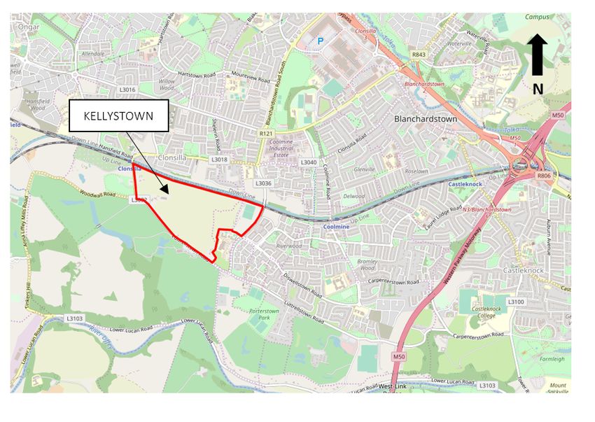
DOCUMENT CONTROL SHEET
6721_RP_02_Information for Screening for Appropriate Assessment

Project No.              6721

Client:                  Fingal County Council

Project Name:            Kellystown Local Area Plan

Report Name:             Information for Screening for Appropriate Assessment

Document No.             RP_02

Issue No.                04

Date:                    22/01/2021

This document has been issued and amended as follows:
 Issue          Status                                                          Date          Prepared   Checked

 01             Draft                                                           18 Aug 2020   MH         MH

 02             Final Draft                                                     10 Sep 2020   MH         MH

 03             Final for Issue                                                 14 Sep 2020   MH         MH

 04             Final                                                           22 Jan 2021   MH         MH
Contents
1     Introduction and Background ..........................................................................................................1
2     Methodology ....................................................................................................................................1
      2.1         Baseline data collection and field visit ............................................................................................................. 1

3     Screening for Appropriate Assessment ...........................................................................................3
      3.1         Background ....................................................................................................................................................... 3
      3.2         Potential zone of influence .............................................................................................................................. 3
      3.3         Study area and surrounding environment ....................................................................................................... 4
      3.3.1       Site location and European sites .................................................................................................................................................................. 4
      3.3.2       Other designated areas (other than European sites) .................................................................................................................................. 6

4     Kellystown Draft Local Area Plan .....................................................................................................7
      4.1         Vision for the Draft LAP .................................................................................................................................... 7
      4.2         The Draft LAP .................................................................................................................................................... 7
      4.2.1       Eastern Development Area (DA1) ................................................................................................................................................................ 7
      4.2.2       Central Development Area (DA2) ................................................................................................................................................................. 8
      4.2.3       Western Development Area (DA3)............................................................................................................................................................... 8
      4.2.4       Proposed Open Space Area .......................................................................................................................................................................... 8

5     Potential impacts from the proposed Local Area Plan, including in-combination effects ...........10
      5.1         European sites and habitats with links to European sites ............................................................................. 10
      5.1.1       Surface and ground water ..........................................................................................................................................................................10
      5.1.2       Foul water ...................................................................................................................................................................................................11
      5.2         Summary of potential impacts of the Draft LAP ............................................................................................ 23

6     Other issues ...................................................................................................................................23
7     Mitigation specific to European sites ............................................................................................23
8     In-combination effects ...................................................................................................................24
9     Screening of amendments .............................................................................................................25
10 Screening conclusion .....................................................................................................................28
Appendix I: Background .........................................................................................................................29
      Stages in the assessment ............................................................................................................................................. 29
      Conservation Objectives of European sites ................................................................................................................. 30

Brady Shipman Martin
Kellystown Local Area Plan
Information for Screening for Appropriate Assessment
1 Introduction and Background
Fingal County Council (FCC) has prepared the Kellystown Local Area Plan (LAP). The LAP seeks to establish a land
use strategy for the proper planning and sustainable development of lands at Kellystown, Dublin 15.
Brady Shipman Martin was appointed by FCC to undertake a screening exercise for Appropriate Assessment (AA).
This will determine the effects, if any, on European sites, of the Draft Local Area Plan. Following public display of
the Draft LAP and review of submissions received, a number of recommended amendments, and motions from
elected representatives, were proposed and incorporated into the Final Plan. The recommended amendments
and motions have also been screened for the requirement for AA.
This document constitutes an Appropriate Assessment Screening Report prepared for this purpose.
European sites are also known as Natura 2000 Sites (Special Areas of Conservation (SAC) and Special Protection
Areas (SPA), and are designated for nature conservation. The requirements for an Appropriate Assessment are set
out under Article 6 of the EU Habitats Directive (92/43/EEC), transposed into Irish law through the European Union
(Birds and Natural Habitats) Regulations 2011-2015 and the Planning and Development Act, 2000 (as amended).
A comprehensive desk study review and a site visit were undertaken and the potential impacts on European sites,
both as a result of the Draft Plan and in-combination with other plans and projects, are appraised in this report.
The work was carried out by Senior Ecologist Matthew Hague BSc MSc Adv. Dip. Plan. & Env. Law CEnv MCIEEM.
Matthew is a highly experienced and qualified ecologist, with a master’s degree in Ecosystem Conservation and
Landscape Management. He has over 18 years of experience in ecological and environmental consultancy, across
a wide range of sectors. He has prepared numerous reports for AA Screening as well as Natura Impact
Statements, for plans and projects of all scales, from small residential developments to nationally important
infrastructure projects.
Matthew is a Chartered Environmentalist (CEnv) and a full member of the Chartered Institute of Ecology and
Environmental Management (MCIEEM). Matthew has also completed an Advanced Diploma in Planning and
Environmental Law, at King’s Inns.
2 Methodology
2.1 Baseline data collection and field visit
A desk-based assessment was undertaken in June, July and August 2020 of the site at Kellystown and the wider
area. This focused on habitats and species that are listed as Qualifying Interests (QI) (in the case of SACs) and
Special Conservation Interests (SCI) (in the case of SPAs) in the designations for European sites. A site survey was
also undertaken, on 19th August 2019. During the survey an assessment of habitat suitability for bird species with
links to European sites was undertaken, in order to appraise the potential for ex-situ effects on European sites.
In addition to this survey, which was undertaken for the purpose of preparing this report, a comprehensive suite
of ecological surveys was undertaken at the site, including habitat, flora and hedgerow surveys, as well as invasive
species, mammal, breeding bird and bat surveys, by specialist ecologists Minogue & Associates. A detailed
Biodiversity Report has been prepared based on these surveys and accompanies the Draft Local Area Plan.
This report takes the following guidance documents into account:
• Appropriate Assessment of Plans and Projects in Ireland – Guidance for Planning Authorities (Department
of Environment, Heritage and Local Government, 2010 revision);
• Appropriate Assessment under Article 6 of the Habitats Directive: Guidance for Planning Authorities.
Circular NPWS 1/10 & PSSP 2/10;
Brady Shipman Martin 6721_2021-01-22_RP_02_04 1Kellystown Local Area Plan
Information for Screening for Appropriate Assessment
• Assessment of Plans and Projects Significantly Affecting European sites: Methodological Guidance on the
Provisions of Article 6(3) and (4) of the Habitats Directive 92/43/EEC (European Commission Environment
Directorate-General, 2001);
• Managing Natura 2000 sites: The Provisions of Article 6 of the Habitats Directive 92/43/EEC. Guidance
issued by the European Commission (21st November 2018).
Information was collated from the organisations and websites listed below:
• Data on European sites and rare and protected plant and animal species contained in the following
databases:
o The National Parks and Wildlife Service (NPWS) of the Department of Culture, Heritage and the
Gaeltacht (www.NPWS.ie);
o The National Biodiversity Data Centre (NDBC) (www.biodiversityireland.ie);
o BirdWatch Ireland (www.birdwatchireland.ie);
o Bat Conservation Ireland (www.batconservationireland.org).
• Information on land-use zoning from the online mapping of the Department of the Environment,
Community and Local Government (http://www.myplan.ie/en/index.html);
• Recent and historical OSi mapping and aerial photography, including www.geohive.ie;
• Photographs taken at the site;
• Information on local watercourses from www.catchments.ie;
• Information on water quality in the area (www.epa.ie);
• Information on soils, geology and hydrogeology in the area (www.gsi.ie);
• Information on the Status of EU Protected Habitats and Species in Ireland (Article 17 report) (NPWS,
August 2019);
• Third National Biodiversity Plan 2017 – 2021 (Department of Culture, Heritage and the Gaeltacht, 2017);
• Fingal Development Plan 2017 – 2023, including the accompanying Appropriate Assessment
documentation (Natura Impact Report).
The report has regard to the following legislative instruments:
• Planning and Development, Act 2000, as amended;
• European Commission (EC) Habitats Directive 92/43/EEC;
• European Commission (EC) Birds Directive 2009/147/EC;
• European Communities (Birds and Natural Habitats) Regulations 2011-2015.
The report takes full account of the details of the Draft Local Area Plan and a detailed examination of all relevant
elements was undertaken. This includes the following documents, among others:
• Biodiversity Report (Minogue & Associates, 2020);
• Strategic Flood Risk Assessment (McCloy Consulting, 2020);
• Sustainable Drainage Strategy (McCloy Consulting, 2020);
• Strategic Environmental Assessment Screening Report (Brady Shipman Martin, 2020, Finalised 2021).
Brady Shipman Martin 6721_2021-01-22_RP_02_04 2Kellystown Local Area Plan
Information for Screening for Appropriate Assessment
Given the amount of information available, including from Fingal County Council, NPWS and other sources, it has
been possible to gather adequate information on the site and the adjacent area (in particular, the European sites),
in order to make an informed, sound judgement as to the potential impacts of the proposed LAP on the qualifying
interests of the European sites.
3 Screening for Appropriate Assessment
3.1 Background
The first part of the Appropriate Assessment process is the Screening phase. Screening identifies the likely effects
of the proposed Plan on European sites that could arise, either alone or in combination with other plans or
projects, and considers whether these impacts are likely to have a significant effect on the European site in view
of the site’s conservation objectives.
In accordance with sections 177U and 177V of the Planning and Development Act 2000, as amended, the AA
screening test must be applied, as follows:
• […]to assess, in view of best scientific knowledge, if that Land use plan or proposed development,
individually or in combination with another plan or project is likely to have a significant effect on the
European site;
• An appropriate assessment is required if it cannot be excluded, on the basis of objective information, that
the development, individually or in combination with other plans or projects, will have a significant effect
on a European site.
Following Screening therefore, if there is a possibility of there being a significant effect on a European site, this
will generate the need for an appropriate assessment for the purposes of Article 6(3) of the Habitats Directive.
This means that if the conclusions at the end of the screening exercise are that significant effects on any European
sites, as a result of the proposed development (in this case the Local Area Plan), either alone or in combination
with other plans and projects, are likely, uncertain or unknown, then an Appropriate Assessment must be carried
out. This is in accordance with established precedent and case law.
3.2 Potential zone of influence
For the risk of a significant effect to occur there must be a 'source', such as a construction site; a 'receptor', such
as a designated site for nature conservation; and a pathway between the source and the receptor, such as a
watercourse that links the construction site to the designated site. Although there may be a risk of an impact it
may not necessarily occur, and if it does occur, it may not be significant.
Identification of a potential effect means that there is a possibility of ecological or environmental damage
occurring, with the level and significance of the impact depending upon the nature and exposure to the potential
effect and the characteristics of the receptor.
There are no set recommended distances for projects to consider European sites as being relevant for
assessment. Rather, for a project NPWS (2010) recommends that ‘Any Natura 2000 sites within the likely zone of
impact of the plan or project’ should be appraised. For projects ‘the distance should be evaluated on a case-by-
case basis with reference to the nature, size and location of the project, and the sensitivities of the ecological
receptors, and the potential for in combination effects’.
In the case of plans, such as the Draft Kellystown LAP, the guidance states that ‘A distance of 15km is currently
recommended in the case of plans, and derives from UK guidance (Scott Wilson et al. 2006)1’.
1
Scott Wilson, Levett-Therivel Sustainability Consultants, Treweek Environmental Consultants and Land Use Consultants. 2006.
Appropriate Assessment of plans.
Brady Shipman Martin 6721_2021-01-22_RP_02_04 3Kellystown Local Area Plan
Information for Screening for Appropriate Assessment
In addition, the guidance states that ‘Natura 2000 sites that are more than 15km from the plan or project area
depending on the likely impacts of the plan or project, and the sensitivities of the ecological receptors, bearing in
mind the precautionary principle. In the case of sites with water dependent habitats or species, and a plan or
project that could affect water quality or quantity, for example, it may be necessary to consider the full extent of
the upstream and/or downstream catchment.’
Therefore, in some instances where there are hydrological connections a whole river catchment or a groundwater
aquifer may need to be included. Similarly where bird flight paths are involved the impact may be on an SPA more
than 15 km away. Taking the guidance into account, as a starting point a search was carried out for all European
sites within 15km of the site at Kellystown. This search was then extended in order to ensure that all European
sites with any potential links to the LAP area were accounted for in the study.
3.3 Study area and surrounding environment
3.3.1 Site location and European sites
Kellystown is located circa 1.5km from Blanchardstown Town Centre, 1.8km from Blanchardstown Main Street
and 9.8km from O’Connell Street, Dublin. The Draft LAP lands are situated directly south of the Royal Canal and
the Dublin-Maynooth railway line and between Diswellstown Road to the east and Clonsilla Road (R121) to the
west. The tree-lined Luttrellstown Road, frames the lands to the south. Diswellstown Road to the east offers an
access point for vehicular and pedestrian traffic to cross the canal and railway line without traversing via a level
crossing. The R121/Clonsilla Road, a well-trafficked route, defines the boundary of the lands to the west and is
part of a network of roads linking Blanchardstown to Lucan.
The site is located in the Liffey sub-catchment of the Liffey and Dublin Bay catchment. There are no watercourses
within the LAP lands themselves2. The nearerst watercourse, other than the Royal Canal, is the River Liffey to the
south, and a tributary to the Liffey that flows the Luttrelstown Golf Course to the south.
The location of the LAP lands is shown in Figure 1.
2
https://gis.epa.ie/EPAMaps/
Brady Shipman Martin 6721_2021-01-22_RP_02_04 4Kellystown Local Area Plan
Information for Screening for Appropriate Assessment
Figure 1: Location of the Kellystown LAP lands3
There are 4 European sites located within a 15km radius of the proposed development (see Figure 2). These are:
• Special Areas of Conservation (SAC)
o Rye Water Valley/Carton SAC (site code 001398), c.5.2km to the west;
o Glenasmole Valley SAC (site code 001209), c.13.6km to the south;
o South Dublin Bay SAC (site code 000210), c.14.1 to the south east;
• Special Protection Areas (SPA)
o South Dublin Bay and River Tolka Estuary SPA (site code 004024), c.12.4km to the east;
Beyond the 15km zone, there are a number of additional European sites:
o North Dublin Bay SAC (site code 000206), c.15.4km to the east;
o Wicklow Mountains (site code 002122), c.15.8km to the south;
o Malahide Estuary SAC (site code 000205), c.16.8km to the north east;
o Baldoyle Bay SAC (site code 000199), c.18.3km to the north east;
o Rogerstown Estuary SAC (site code 000208), c.19.7km to the north east;
o Howth Head SAC (site code 000202), c.21.0km to the east;
o Rockabill to Dalkey Island SAC (site code 003000), c.21.6km to the east;
o Red Bog, Kildare SAC (site code 000397), c.21.6km to the south west;
o Knocksink Wood SAC (site code 000725), c.22.7 to the south east;
3
Environmental Protection Agency (EPA) website: https://gis.epa.ie/EPAMaps/default (OpenStreet Maps)
Brady Shipman Martin 6721_2021-01-22_RP_02_04 5Kellystown Local Area Plan
Information for Screening for Appropriate Assessment
o Ireland’s Eye SAC (site code 002193), c.23.0km to the east;
o North Bull Island SPA (site code 004006), c.15.5km to the east;
o Broadmeadow/Swords Estuary (Malahide Estuary) SPA (site code 004025), c.16.9km to the north
east;
o Wicklow Mountains SPA (site code 004040), c.17.3km to the south;
o Baldoyle Bay SPA (site code 004016), c.18.5km to the north east;
o Rogerstown Estuary SPA (site codes 004015), c.20.4km to the north east;
o Poulaphouca Reservoir SPA (site code 004063), c.22.4km to the south west;
o Ireland’s Eye SPA (site code 004117), c.22.8km to the east;
o Howth Head Coast SPA (site code 004113), c.23.8km to the east;
o Dalkey Islands SPA (site code 004172), c.24.0km to the south east.
Figure 2: Kellystown LAP lands, including a 15km buffer, with European sites shown (Source: OpenStreetMap)
3.3.2 Other designated areas (other than European sites)
The nearest site designated for nature conservation, not otherwise designated as a European site, is the Royal
Canal proposed Natural Heritage Area (pNHA site code 002103, which is located immediately to the north of the
LAP lands (to the north of the Dublin-Maynooth railway line). The Liffey Valley pNHA (site code 000128) is located
Brady Shipman Martin 6721_2021-01-22_RP_02_04 6Kellystown Local Area Plan
Information for Screening for Appropriate Assessment
approximately 200m to the south of Luttrellstown Road (the road forms the southern boundary of the LAP lands).
The Grand Canal pNHA (site code 002104) is approximately 5km to the south of the LAP lands.
These are included in this report in order to address their potential to act as supporting sites for the European
sites.
4 Kellystown Draft Local Area Plan
4.1 Vision for the Draft LAP
The vision and development strategy for Kellystown is intended to guide its long-term future growth through
articulation of how the LAP lands will look, function and feel. The vision statement is based on community
consultation (undertaken May-July 2019) and an analysis of the key opportunities and challenges for Kellystown.
The proposed Vision Statement for the area as set out in the Draft LAP states:
“The vision for Kellystown is to promote the development of a distinctive, sustainable, high quality new
residential quarter, connected to the neighbouring suburbs of Clonsilla and Carpenterstown. Kellystown
will provide a sustainable residential community, comprising a choice of high quality new homes, with a
mix of dwelling types, size and tenure based around a new civic square that incorporates local services
with new schools, public open space and access to high capacity public transport links.
Kellystown will offer a good quality of life to its residents and balance the need for additional housing, with
community, economic, cultural, educational and recreational facilities. The Draft LAP seeks to create a place with
a strong sense of community and to build on its existing identity by incorporating valuable existing elements of
the built and natural environment.
4.2 The Draft LAP
The Draft LAP promotes best practice architectural solutions for the overall development of Kellystown and is a
long-term strategy for the sustainable development of the LAP lands with a diversity and mix of uses to create a
place where a balance is achieved between the natural and built environment.
Existing features, including treelines and hedgerows have been used to define the development areas, as has the
zoning of the lands and the proposed alignment of the Kellystown Link road. The proposed phasing of the LAP also
relates to the defined development areas. The identified Development Areas are set out in the Sections below
and are shown in Figure 3.
4.2.1 Eastern Development Area (DA1)
The Eastern Development Area (DA1) is approximately 14.9ha (gross) in size and is bounded by the Royal Canal to
the north; Diswellstown Road to the east; Luttrellstown Education Campus to the south (Scoil Choilm Community
National School and Luttrellstown Community College) as well as the alignment of the proposed Kellystown Link
Road; and Development Area 2 (DA2) to the west, with the boundary delineated by a mature hedgerow. The
entire development area is zoned RA - Residential.
The land currently accommodates St. Mochta’s Football Club, St. Brigid’s Halting Site , a small number of dwellings
and agricultural / pasture land.
DA1 is been designed to accommodate a new high-quality residential quarter. The goal of the development area is
to provide for a range of housing unit types, with a range of net densities of between c.50-c.75 units/ha
approximately, that would support a diverse and changing community.
Brady Shipman Martin 6721_2021-01-22_RP_02_04 7Kellystown Local Area Plan
Information for Screening for Appropriate Assessment
4.2.2 Central Development Area (DA2)
The Central Development Area (DA2) is approximately 7.4ha (gross) in size and is bounded by DA1 and DA3 to the
east and west respectively. The northern boundary is defined by the Dublin-Maynooth railway line/Royal Canal
corridor and the southern boundary by the alignment of the Kellystown Link Road. The lands are currently
managed for agricultural purposes. The entire development area is zoned RA - Residential.
DA2 will form the ‘heart’ of Kellystown and will provide a range of important amenities to support day-to-day life
in the area, including a local centre, a primary and secondary school, a central open space/civic square as well as
residential development, with a range of net densities of between c.50-c.75 units/ha approximately. Access to the
lands will be achieved from the proposed Kellystown Link Road.
An appropriately sized local centre is proposed to provide for everyday shopping facilities and other local services
(e.g. newsagent, doctor, pharmacy, hairdresser, etc.). It is anticipated that weekly shopping activities will be
undertaken at the nearby Blanchardstown Shopping Centre or within the nearby centre of Clonsilla which
provides for Level 4 retail provision.
4.2.3 Western Development Area (DA3)
The Western Development Area (DA3) is approximately 10.23ha (gross) in size and is bounded by the R121 to the
west, the Dublin-Maynooth Railway Line / Royal Canal corridor to the north, DA2 to the east and by the proposed
alignment of the Kellystown Link road to the south. The lands are located adjacent to Clonsilla Railway Station and
the associated railway crossing. Currently, the lands accommodate a number of dispersed dwellings including
Greenmount House. The majority of the development area is zoned RA - Residential, with a small element of OS –
Open Space to the south west corner (excluded for development purposes).
DA3 is intended to accommodate a new high-quality residential quarter, with a range of net densities of between
c.50-c.75 units/Ha approximately. The design approach will incorporate a strong urban form consisting of a series
residential blocks, linked through an internal road network incorporating home zones with one access point onto
the proposed Kellystown Link road.
4.2.4 Proposed Open Space Area
The southern portion of the LAP lands, located to the south of the proposed alignment of the Kellystown Link
Road, are zoned ‘OS’ - Open Space. The lands are bounded to the east by Luttrellstown Community College and
Scoil Choilm Community National School and to the south/east by Luttrellstown Road. The southern LAP lands are
currently in agricultural use, and as well as containing a small number of dispersed dwellings, include protected
structure No. 945 ‘The Gables’ situated on Luttrellstown Road.
Table 1 below sets out the Development Areas characteristics for the Eastern, Central and Western Development
Area.
Table 1: Development Areas Identified in the Draft LAP
Development Gross Area Density Range Approximate Community Infrastructure
Area (hectares) (Gross) units
Eastern (DA1) 14.9 38-57 571-857 Green routes
Primary & Secondary School
Civic Square
Central (DA2) 7.4 16-24 119-179 Local Centre
Green Route
Pedestrian Bridge
Brady Shipman Martin 6721_2021-01-22_RP_02_04 8Kellystown Local Area Plan
Information for Screening for Appropriate Assessment
Development Gross Area Density Range Approximate Community Infrastructure
Area (hectares) (Gross) units
Green Route
Western (DA3) 10.23 36-53 365-547
Open Space incorporating Ring Barrow
Total 32.53 1,055-1,583
Figure 3: Kellystown Draft LAP Development Areas4
The Draft LAP contains a number of objectives (Objectives 8.1 – 8.14) that are intended to ensure the delivery of
significant green and blue infrastructure within the Draft LAP area.
These Objectives (for Example, Objective 8.1: Promote the conservation and enhancement of biodiversity having
regard to the policies and objectives of the Fingal Development Plan, the Fingal Heritage Plan and the Fingal
Biodiversity Plan while allowing for appropriate development, access arrangements and recreational activity) will
ensure that key existing features of high biodiversity value, such as the mature tree lines, hedgerows and the
riparian corridor along the Royal Canal are protected and enhanced in so far as is practicable throughout the
delivery of the Draft LAP development objectives.
4
Fingal County Council (2020). Kellystown Draft Local Area Plan, Figure 5.2, Page 19
Brady Shipman Martin 6721_2021-01-22_RP_02_04 9Kellystown Local Area Plan
Information for Screening for Appropriate Assessment
5 Potential impacts from the proposed Local Area Plan, including in-
combination effects
5.1 European sites and habitats with links to European sites
The Kellystown LAP lands are not under any wildlife or conservation designation. Furthermore, no rare,
threatened or legally protected plant species, as listed in the Irish Red Data Book 1 – Vascular Plants (Curtis &
McGough, 1988), the Flora Protection Order, 2015 or the EU Habitats Directive, are known to occur within the
site. None were found during the course of the surveys undertaken in the preparation of this report or by
Minogue & Associates.
According to the Biodiversity Report (included at Appendix 1 of the Draft LAP), a number of the hedgerows and
other features have local ecological value, however no features of any ecological significance in the context of
European sites are present within the LAP lands. No evidence of any habitats or species with links to European
sites was recorded in the desk study or during any of the field surveys undertaken and no ‘reservoir’ type habitats
(habitats which have the potential to support Qualifying Interest/Special Conservation Interest species in any
European site) are present.
There will be no loss of any habitat or species listed as a Qualifying Interest or Special Conservation Interest of any
designated site as a consequence of the implementation of any elements of the Draft LAP. The lands within the
Kellystown site do not in any way act as an important ex-situ site for any European site (SPA) SCIs.
5.1.1 Surface and ground water
Other than minor ditches there are no watercourses within the Draft LAP lands. There is, nevertheless, a potential
water pathway, between the Draft LAP lands area and coastal European sites associated with Dublin Bay (the
nearest of which, South Dublin Bay and River Tolka Estuary SPA, is over 12km to the east). There is also a potential
groundwater pathway between the Draft LAP lands and the European sites should indirect discharges (i.e.
spillages to ground) occur. The potential pathway is via the Royal Canal along the northern boundary of the site
and the River Liffey, which is located to the south. There is however no pathway between the Draft LAP lands and
the nearest European site (Rye Water Valley/Carton SAC). This site is over 5km to the west and entirely
unconnected.
Despite the presence of these theoretical indirect pathways, the risk of contamination of any watercourses or
groundwater by LAP-related development is extremely low, and even in the event of a pollution incident occurring
during the implementation of the Draft LAP that would be significant enough to impact upon surface/ground
water quality locally, it is reasonable to assume that this would not be perceptible in the offshore European sites,
for the following reasons:
• The distance to the European sites – the nearest designated site in Dublin Bay (South Dublin Bay and
River Tolka Estuary SPA) is over 12km (straight-line distance to the east), and any pollution entering the
local surface water drainage network from any construction site associated with the Draft LAP area would
be so diluted as to be entirely undetectable by the time the water enters the sea;
• The fact that a significant level of dilution and mixing of surface and sea water would occur in any event.
Upon reaching the sea any pollutants would be even further diluted and dissipated by the receiving
waters;
• There is no conceivable pathway between the Draft LAP lands at Kellystown and any other European
sites, such as the Rye Water Valley/Carton SAC.
It is clear that there is no possibility of any significant effects on European sites via surface or ground water,
arising out of the implementation of the Draft LAP. Regardless, the Draft LAP includes a series of specific
Brady Shipman Martin 6721_2021-01-22_RP_02_04 10Kellystown Local Area Plan Information for Screening for Appropriate Assessment objectives to ensure protection of surface and ground water as well as flood risk management (refer to Objectives 11.9 to 11.25). As confirmed in the Draft LAP, any development arising will be designed in accordance with the principles of Sustainable Drainage Systems (SuDS) as embodied in the recommendations of the Greater Dublin Strategic Drainage Study (GDSDS). The GDSDS addresses the issue of sustainability by requiring designs to comply with a set of drainage criteria which aim to minimize the impact of urbanization, by replicating the run-off characteristics of the greenfield site. The criteria provide a consistent approach to addressing the increase in both rate and volume of run-off, as well as ensuring the environment is protected from any pollution from roads and buildings. SuDS are a requirement of Fingal County Council (including under Objective SW04 of the Fingal County Development Plan 2017-2023) and under the GDSDS and the Regional Code of Practice for Drainage Works. Additionally these systems are recommended under the 2009 guidelines published by the OPW, ‘The Planning System and Flood Risk Management’. SuDS are an environmentally effective approach to managing surface water on developed lands. This most closely reflects natural catchment behaviour where rainfall either infiltrates through the soil or runs off slowly over the ground surface to the nearest watercourse. This is an important element of climate change mitigation and will act to future-proof communities against adverse weather effects. SuDS offer a comprehensive approach to the management of water on a site, to delay and reduce run-off through infiltration, transpiration, evapotranspiration and re-use, whilst also providing improvements to water quality, amenity and biodiversity. Shallow surface based systems to manage surface water are encouraged in favour of underground infrastructure such as pipes and culverts. In tandem with this, runoff control measures favoured include surface based systems such as weirs and orifices rather than proprietary systems contained underground in manholes. Runoff from green areas should never be permitted to enter closed sewer networks, and groundwater infiltration must be favoured over discharge to open surface water (ditches, streams). A Surface Water Management Plan comprising of both a Flood Risk Assessment and a Sustainable Drainage Strategy has been developed for Kellystown, prepared by McCloy Consulting Engineers on behalf of Fingal County Council (please refer to Appendix 2 to the Draft LAP), and identifies various measures that may be employed throughout the development taking into account the existing surface water infrastructure in place across the site. These SuDS measures must be incorporated into the development in line with appropriate sustainable drainage practices and include for limiting runoff rates and providing site, source and regional controls. Such measures must be developed in conjunction with approved landscape and open space plans and must align with the taking in charge requirements of the local authority. There is no possibility of the implementation of the Draft LAP objectives adversely impacting on the conservation objectives of any of the QIs or SCIs of any European sites in, or associated with, Dublin Bay as a result of surface water run-off or discharges to groundwater. 5.1.2 Foul water The Draft LAP includes specific objectives in relation to wastewater (refer to Objectives 11.4 to 11.8). Development of the LAP lands will be dependent on the progress of relevant improvement works and will be subject to the agreement of Irish Water. All foul infrastructure shall be designed and constructed in consultation with Irish Water. In April 2019, An Bord Pleanála granted permission to Irish Water for revisions to the approved scheme (granted permission in 2012) to upgrade the Ringsend Treatment Plant, which is currently operating at capacity. The upgrade permitted will include the use of Aerobic Granular Sludge (AGS) technology as well as the omission of the previously approved long sea outfall tunnel, which would have deposited treated material 9km out to sea. The approved upgrades to the treatment plant will allow it to increase its capacity from 1.64 million PE (population equivalent) to 2.4 million PE and will enable further population growth in the Dublin region, including at Brady Shipman Martin 6721_2021-01-22_RP_02_04 11
Kellystown Local Area Plan
Information for Screening for Appropriate Assessment

Kellystown. Irish Water plans to invest over €400 million in the staged upgrade of the plant, with the major phase
of the works expected to be completed in 2020, with all works scheduled to be completed by 2025.
The Greater Dublin Drainage (GDD) Project is a long term scheme designed to provide the strategic drainage
infrastructure required for the Greater Dublin Area (GDA) in the period up to 2050. It is currently estimated that
construction of a new regional wastewater treatment plant in the Fingal area and orbital pipelines, stretching
from Blanchardstown to Clonshaugh, will be operational by 2026. The project also includes a new pumping station
at Abbotstown and An Bord Pleanála granted planning permission for the GDD Project in November 2019.
The Draft LAP Lands at Kellystown will be served in the long term by both the Ringsend Treatment Plant and the
GDD. However, it is important to note that development will only be permitted where there is adequate
treatment capacity. Development will be dependent on the progress of relevant improvement works and will be
subject to the agreement of Irish Water. All foul infrastructure shall be designed and constructed in consultation
with Irish Water.
In particular, Objective 11.7 of the Draft LAP (Permit new development only where it can be clearly demonstrated
that there is adequate capacity in the wastewater disposal infrastructure in accordance with applicable
requirements and standards, including urban wastewater treatment disposal standards) will ensure that there is
no possibility of the implementation of the Draft LAP objectives adversely impacting on the conservation
objectives of any of the QIs or SCIs of any European sites in, or associated with, Dublin Bay (currently categorized
as “unpolluted” according to the EPA database5) as a result of foul water discharges.
There is no possibility of any other potential direct, indirect or secondary impacts on any European site as a result
of the implementation of the Draft LAP objectives. For example there will be no land-take from any European site
and there will be no resource requirements such as water abstraction.
There will be no loss, fragmentation, disruption, disturbance or other change to any element of any European site
as a result of the implementation of any of the Draft LAP objectives, and no interference with the key
relationships that define the structure or function of any European site.
Details of the potential impacts of the implementation of the Draft LAP on European sites are presented in Table
2.

5
    https://gis.epa.ie/EPAMaps/

Brady Shipman Martin     6721_2021-01-22_RP_02_04                                                                 12
Kellystown Local Area Plan
Information for Screening for Appropriate Assessment
Table 2 lists relevant European sites and outlines their Qualifying Interests/Special Conservation Interests and Conservation Objectives*
th
European Site Reasons for designation (information correct as of 17 August 2020) Source – Pathway – Receptor link
(*denotes a priority habitat)
Rye Water Valley/Carton 7220 Petrifying springs with tufa formation (Cratoneurion)* There is no hydrological link or any other pathway between the Draft LAP lands at Kellystown and
SAC (site code 001398), Species this SAC. It is over 5km distant and is completely unconnected. Furthermore there will be no loss of
c.5.2km to the west 1016 Desmoulin's Whorl Snail (Vertigo moulinsiana) habitat or species, fragmentation or disturbance to the qualifying interests of this SAC as a result of
1014 Narrow-mouthed Whorl Snail (Vertigo angustior) the implementation of any of the objectives of the Draft LAP.
According to this SAC’s site Generic Conservation Objectives
th
document (Version 7, dated 7 April 2020), for each of the
listed QIs, the Conservation Objectives are to maintain or
restore the favourable conservation condition of the Annex I
habitat(s) and/or the Annex II species for which the SAC has
been selected.
Glenasmole Valley SAC 6210 Semi-natural dry grasslands and scrubland facies on There is no hydrological link or any other pathway between the Draft LAP lands at Kellystown and
(site code 001209), calcareous substrates (Festuco-Brometalia) (* important this SAC. It is over 13km distant and is completely unconnected. Furthermore there will be no loss
c.13.6km to the south orchid sites) of habitat or species, fragmentation or disturbance to the qualifying interests of this SAC as a result
6410 Molinia meadows on calcareous, peaty or clayey-silt-laden of the implementation of any of the objectives of the Draft LAP.
soils (Molinion caeruleae)
7220 Petrifying springs with tufa formation (Cratoneurion)
According to this SAC’s site Generic Conservation Objectives
th
document (Version 7, dated 7 April 2020), for each of the
listed QIs, the Conservation Objectives are to maintain or
restore the favourable conservation condition of the Annex I
habitat(s) and/or the Annex II species for which the SAC has
been selected.
South Dublin Bay SAC 1140 Mudflats and sandflats not covered by seawater at low tide No significant effects on water quality, and therefore on the site’s QIs, are predicted.
(site code 000210),
Surface/ground water arising during the implementation of the objectives of the Draft LAP could
c.14.1km to the south The following habitats are listed as Qualifying Interests on the
potentially contain pollutants (foul water, silt, hydrocarbons and other chemicals). Such
east NPWS website, but are not included in the Conservation
contaminated water could potentially discharge to the ground or the local surface water drainage
Objectives document:
network and from there, eventually, to the sea.
(1210 Annual vegetation of drift lines There would be no significant effects on the conservation objectives of the European site should
1310 Salicornia and other annuals colonising mud and sand this occur, given the nature and location of the Draft LAP lands at Kellystown and the policies and
2110 Embryonic shifting dunes) objectives set out in the Draft LAP. Even in the event of a pollution incident significant enough to
Brady Shipman Martin 6721_2021-01-22_RP_02_04 13Kellystown Local Area Plan
Information for Screening for Appropriate Assessment
th
European Site Reasons for designation (information correct as of 17 August 2020) Source – Pathway – Receptor link
(*denotes a priority habitat)
According to this SAC’s site Conservation Objectives document impact upon surface/ground water quality locally, it is reasonable to assume that this would not be
nd
(Version 1, dated 22 August 2013), for the listed QI, the perceptible in South Dublin Bay SAC.
Conservation Objective is to maintain the favourable conservation
This is due to the significant separation between the Draft LAP area and the European site – it is
condition of the Annex I habitat for which the SAC has been
over 14km (straight line distance) from the SAC. In addition, significant dilution and mixing of
selected.
surface and sea water would occur.
There will be no loss of habitat or species, or disturbance to the qualifying interests of this site as a
result of the implementation of the objectives of the Draft LAP.
No operational impacts on this European site related to foul water management are envisaged as a
result of the implementation of the objectives of the Draft LAP.
North Dublin Bay SAC 1140 Mudflats and sandflats not covered by seawater at low tide No significant effects on water quality, and therefore on the site’s QIs, are predicted.
(site code 000206), 1210 Annual vegetation of drift lines
Surface/ground water arising during the implementation of the objectives of the Draft LAP could
c.15.4km to the east 1310 Salicornia and other annuals colonising mud and sand
potentially contain pollutants (foul water, silt, hydrocarbons and other chemicals). Such
1330 Atlantic salt meadows (Glauco-Puccinellietalia maritimae)
contaminated water could potentially discharge to the ground or the local surface water drainage
1410 Mediterranean salt meadows (Juncetalia maritimi)
network and from there, eventually, to the sea.
2110 Embryonic shifting dunes
2120 Shifting dunes along the shoreline with Ammophila arenaria There would be no significant effects on the conservation objectives of the European site should
(white dunes) this occur, given the nature and location of the Draft LAP lands at Kellystown and the policies and
2130 Fixed coastal dunes with herbaceous vegetation (grey objectives set out in the Draft LAP. Even in the event of a pollution incident significant enough to
dunes)* impact upon surface/ground water quality locally, it is reasonable to assume that this would not be
2190 Humid dune slacks perceptible in North Dublin Bay SAC.
1395 Petalwort (Petalophyllum ralfsii)
This is due to the significant separation between the Draft LAP area and the European site – it is
over 15km (straight line distance) from the SAC. In addition, significant dilution and mixing of
According to this SAC’s site Conservation Objectives document
th surface and sea water would occur.
(Version 1, dated 06 November 2013), for each of the listed
QIs, the Conservation Objective is to maintain or restore the There will be no loss of habitat or species, or disturbance to the qualifying interests of this site as a
favourable conservation condition of the Annex I habitat(s) result of the implementation of the objectives of the Draft LAP.
and/or the Annex II species for which the SAC has been
No operational impacts on this European site related to foul water management are envisaged as a
selected.
result of the implementation of the objectives of the Draft LAP.
Wicklow Mountains SAC 3110 Oligotrophic waters containing very few minerals of sandy There is no hydrological link or any other pathway between the Draft LAP lands at Kellystown and
(site code 002122), plains (Littorelletalia uniflorae) this SAC. It is almost 16km distant and is completely unconnected. Furthermore there will be no
c.15.8km to the south 3160 Natural dystrophic lakes and ponds loss of habitat or species, fragmentation or disturbance to the qualifying interests of this SAC as a
4010 Northern Atlantic wet heaths with Erica tetralix result of the implementation of any of the objectives of the Draft LAP.
4030 European dry heaths
4060 Alpine and Boreal heaths
Brady Shipman Martin 6721_2021-01-22_RP_02_04 14Kellystown Local Area Plan
Information for Screening for Appropriate Assessment
th
European Site Reasons for designation (information correct as of 17 August 2020) Source – Pathway – Receptor link
(*denotes a priority habitat)
6130 Calaminarian grasslands of the Violetalia calaminariae
6230 Species-rich Nardus grasslands, on siliceous substrates in
mountain areas (and submountain areas, in Continental
Europe)*
7130 Blanket bogs (* if active bog)
8110 Siliceous scree of the montane to snow levels
(Androsacetalia alpinae and Galeopsietalia ladani)
8210 Calcareous rocky slopes with chasmophytic vegetation
8220 Siliceous rocky slopes with chasmophytic vegetation
91A0 Old sessile oak woods with Ilex and Blechnum in the British
Isles
1355 Otter (Lutra lutra)
According to this SAC’s site Conservation Objectives document
st
(Version 1, dated 31 July 2017), for each of the listed QIs, the
Conservation Objective is to maintain or restore the favourable
conservation condition of the Annex I habitat(s) for which the
SAC has been selected.
Malahide Estuary SAC 1140 Mudflats and sandflats not covered by seawater at low tide There is no hydrological link or any other pathway between the Draft LAP lands at Kellystown and
(site code 000205), 1310 Salicornia and other annuals colonising mud and sand this SAC. It is almost 17km distant and is completely unconnected. Furthermore there will be no
c.16.8km to the north 1330 Atlantic salt meadows (Glauco-Puccinellietalia maritimae) loss of habitat or species, fragmentation or disturbance to the qualifying interests of this SAC as a
east 1410 Mediterranean salt meadows (Juncetalia maritimi) result of the implementation of any of the objectives of the Draft LAP.
2120 Shifting dunes along the shoreline with Ammophila arenaria
(white dunes)
2130 Fixed coastal dunes with herbaceous vegetation (grey dunes)*
According to this SAC’s site Conservation Objectives document
th
(Version 1, dated 27 May 2013), for each of the listed QIs, the
Conservation Objective is to maintain or restore the favourable
conservation condition of the Annex I habitat(s) and/or the
Annex II species for which the SAC has been selected.
Baldoyle Bay SAC (site 1140 Mudflats and sandflats not covered by seawater at low tide There is no hydrological link or any other pathway between the Draft LAP lands at Kellystown and this
code 000199), c.18.3km 1310 Salicornia and other annuals colonising mud and sand SAC. It is over 18km distant and is completely unconnected. Furthermore there will be no loss of
to the north east 1330 Atlantic salt meadows (Glauco-Puccinellietalia maritimae) habitat or species, fragmentation or disturbance to the qualifying interests of this SAC as a result of
1410 Mediterranean salt meadows (Juncetalia maritimi) the implementation of any of the objectives of the Draft LAP.
Brady Shipman Martin 6721_2021-01-22_RP_02_04 15Kellystown Local Area Plan
Information for Screening for Appropriate Assessment
th
European Site Reasons for designation (information correct as of 17 August 2020) Source – Pathway – Receptor link
(*denotes a priority habitat)
According to this SAC’s site Conservation Objectives document
th
(Version 1, dated 19 November 2012), for each of the listed
QIs, the Conservation Objective is to maintain the favourable
conservation condition of the Annex I habitat(s) and/or the
Annex II species for which the SAC has been selected.
Rogerstown Estuary SAC 1130 Estuaries There is no hydrological link or any other pathway between the Draft LAP lands at Kellystown and
(site code 000208), 1140 Mudflats and sandflats not covered by seawater at low this SAC. It is almost 20km distant and is completely unconnected. Furthermore there will be no
c.19.7km to the north tide loss of habitat or species, fragmentation or disturbance to the qualifying interests of this SAC as a
east 1310 Salicornia and other annuals colonising mud and sand result of the implementation of any of the objectives of the Draft LAP.
1330 Atlantic salt meadows (Glauco-Puccinellietalia maritimae)
1410 Mediterranean salt meadows (Juncetalia maritimi)
2120 Shifting dunes along the shoreline with Ammophila
arenaria (white dunes)
2130 Fixed coastal dunes with herbaceous vegetation (grey
dunes)*
According to this SAC’s site Conservation Objectives document
th
(Version 1, dated 14 August 2013), for each of the listed QIs,
the Conservation Objective is to maintain or restore the
favourable conservation condition of the Annex I habitat(s)
and/or the Annex II species for which the SAC has been
selected.
Howth Head SAC (site 1230 Vegetated sea cliffs of the Atlantic and Baltic coasts There is no hydrological link or any other pathway between the Draft LAP lands at Kellystown and
code 000202), c.21.0km 4030 European dry heaths this SAC. It is approximately 21km distant and is completely unconnected. Furthermore there will
to the east be no loss of habitat or species, fragmentation or disturbance to the qualifying interests of this SAC
According to this SAC’s site Conservation Objectives document as a result of the implementation of any of the objectives of the Draft LAP.
th
(Version 1, dated 06 December 2016), for each of the listed QIs,
the Conservation Objective is to maintain the favourable
conservation condition of the Annex I habitats for which the SAC
has been selected.
Rockabill to Dalkey Island 1170 Reefs No significant effects on water quality, and therefore on the site’s QIs, are predicted.
SAC (site code 003000), 1351 Harbour porpoise (Phocoena phocoena)
Surface/ground water arising during the implementation of the objectives of the Draft LAP could
c.21.6km to the east;
potentially contain pollutants (foul water, silt, hydrocarbons and other chemicals). Such
According to this SAC’s site Conservation Objectives document
th contaminated water could potentially discharge to the ground or the local surface water drainage
(Version 1, dated 07 May 2013), for each of the listed QIs, the
network and from there, eventually, to the sea.
Conservation Objective is to maintain the favourable conservation
Brady Shipman Martin 6721_2021-01-22_RP_02_04 16Kellystown Local Area Plan
Information for Screening for Appropriate Assessment
th
European Site Reasons for designation (information correct as of 17 August 2020) Source – Pathway – Receptor link
(*denotes a priority habitat)
condition of the Annex I habitat(s) and/or the Annex II species for There would be no significant effects on the conservation objectives of the European site should
which the SAC has been selected. this occur, given the nature and location of the Draft LAP lands at Kellystown and the policies and
objectives set out in the Draft LAP. Even in the event of a pollution incident significant enough to
impact upon surface/ground water quality locally, it is reasonable to assume that this would not be
perceptible in Rockabill to Dalkey Island SAC.
This is due to the significant separation between the Draft LAP area and the European site – it is
over 21km (straight line distance) from the SAC. In addition, significant dilution and mixing of
surface and sea water would occur.
There will be no loss of habitat or species, or disturbance to the qualifying interests of this site as a
result of the implementation of the objectives of the Draft LAP.
No operational impacts on this European site related to foul water management are envisaged as a
result of the implementation of the objectives of the Draft LAP.
Red Bog, Kildare SAC 7140 Transition mires and quaking bogs There is no hydrological link or any other pathway between the Draft LAP lands at Kellystown and
(site code 000397), this SAC. It is almost 22km distant and is completely unconnected. Furthermore there will be no
c.21.6km to the south According to this SAC’s site Conservation Objectives document loss of habitat or species, fragmentation or disturbance to the qualifying interests of this SAC as a
th
west (Version 1, dated 17 July 2019), for the listed QI, the result of the implementation of any of the objectives of the Draft LAP.
Conservation Objective is to maintain the favourable conservation
condition of the Annex I habitat for which the SAC has been
selected.
Knocksink Wood SAC 7220 Petrifying springs with tufa formation (Cratoneurion)* There is no hydrological link or any other pathway between the Draft LAP lands at Kellystown and
(site code 000725), 91E0 Alluvial forests with Alnus glutinosa and Fraxinus excelsior this SAC. It is almost 23km distant and is completely unconnected. Furthermore there will be no
c.22.7km to the south (Alno-Padion, Alnion incanae, Salicion albae)* loss of habitat or species, fragmentation or disturbance to the qualifying interests of this SAC as a
east result of the implementation of any of the objectives of the Draft LAP.
According to this SAC’s site Generic Conservation Objectives
th
document (Version 7, dated 7 April 2020), for each of the listed
QIs, the Conservation Objectives are to maintain or restore the
favourable conservation condition of the Annex I habitat(s) and/or
the Annex II species for which the SAC has been selected.
Ireland’s Eye SAC (site 1220 Perennial vegetation of stony banks There is no hydrological link or any other pathway between the Draft LAP lands at Kellystown and
code 002193), c.23km to 1230 Vegetated sea cliffs of the Atlantic and Baltic coasts this SAC. It is approximately 23km distant and is completely unconnected. Furthermore there will
the east be no loss of habitat or species, fragmentation or disturbance to the qualifying interests of this SAC
According to this SAC’s site Conservation Objectives document as a result of the implementation of any of the objectives of the Draft LAP.
th
(Version 1, dated 27 January 2017), for each of the listed QIs, the
Conservation Objective is to maintain the favourable conservation
Brady Shipman Martin 6721_2021-01-22_RP_02_04 17You can also read


