HISTORICAL RESOURCES SURVEY REPORT - CAPITAL EXPRESS CENTRAL - INTENSIVE-LEVEL SURVEY: WALKER BROTHERS WAREHOUSE, 807 EAST 4TH STREET - MY35CAPEX.COM
←
→
Page content transcription
If your browser does not render page correctly, please read the page content below
Historical Resources Survey Report
Capital Express Central – Intensive-level Survey:
Walker Brothers Warehouse, 807 East 4th Street
Project Name: Interstate Highway (I-) 35 Capital Express Central Project
Project Limits: U.S. Highway (US) 290 East to US 290 West/State Highway (SH) 71
District(s): Austin
County(s): Travis
CSJ Number(s): 0015-13-388
Principal Investigators: Rick Mitchell and Emily Pettis, Mead & Hunt, Inc.
Report Completion Date: May 2022

The environmental review, consultation, and other actions required by applicable Federal environmental laws for this project are being, or have been,
carried-out by TxDOT pursuant to 23 U.S.C. 327 and a Memorandum of Understanding dated 12-9-2019, and executed by FHWA and TxDOT.

This historical resources survey report is produced for the purposes of meeting requirements
under Section 106 of the National Historic Preservation Act, the Antiquities Code of Texas, and
other cultural resource legislation related to environmental clearance as applicable.

               Historical Resources Survey Report, Texas Department of Transportation, Environmental Affairs Division
                                                                                                                            1

           istorical Studies Report, Texas Department of Transportation, Environmental Affairs Division                 1
                                                                                                                        1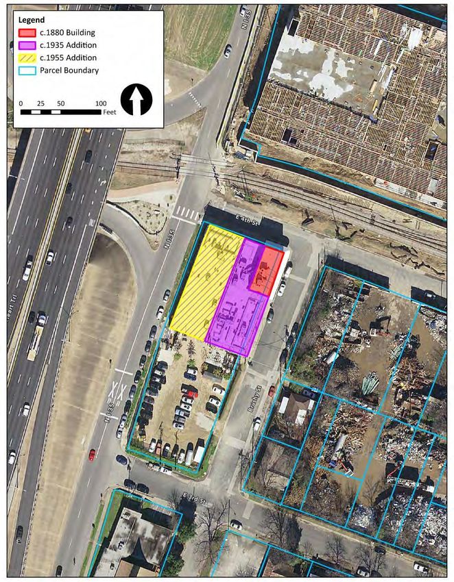
Abstract

The proposed Interstate Highway (I-) 35 Capital Express Central Project is to improve an
approximately 8-mile segment of I-35 from U.S. Highway (US) 290 East to US 290 West/State
Highway 71. The project Area of Potential Effects (APE) includes a portion of the Walker
Brothers Warehouse at 807 East 4th Street, which was recommended as individually eligible for
the National Register of Historic Places (NRHP) as part of the 2016 East Austin Survey
conducted by Hardy-Heck-Moore, Inc. Based on these previous findings, the Texas Department
of Transportation (TxDOT) concluded that intensive-level work would be required to provide a
definitive NRHP evaluation for the property. A description of the overall project area and
detailed survey results are included in the draft reconnaissance Historic Resources Survey
Report dated March 2022.

On behalf of the TxDOT Environmental Affairs Division, Mead & Hunt, Inc. performed an
intensive survey in January 2022 to provide a definitive evaluation of NRHP eligibility for the
Walker Brothers Warehouse. The intensive survey included extensive research, fieldwork, and
comparative analysis.

Based on the findings of the intensive survey, the Walker Brothers Warehouse is recommended
eligible for listing in the NRHP under Criterion A in the area of Industry and Criterion C in the
area of Architecture, both at the local level of significance. NRHP-eligible boundaries are limited
to the building footprint on the north part of the property parcel. The south part of the property
parcel, an open storage area surrounded by non-historic fencing, was not historically associated
with the warehouse building. Proposed build alternatives would move I-35 main lanes closer to
the NRHP-eligible building. However, vehicular lanes would be depressed below grade in both
build alternatives, resulting in reduced noise and visual impacts compared to the existing
freeway configuration.

               Historical Resources Survey Report, Texas Department of Transportation, Environmental Affairs Division
                                                                                                                            2

           istorical Studies Report, Texas Department of Transportation, Environmental Affairs Division                 2
                                                                                                                        2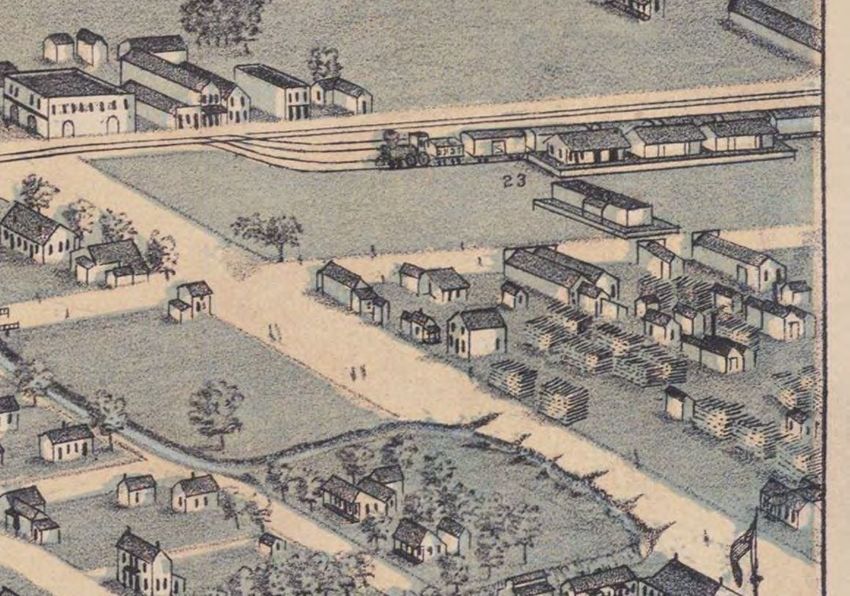
Table of Contents

Abstract........................................................................................................................................... 2
Project Identification ...................................................................................................................... 4
Area of Potential Effects (APE) ...................................................................................................... 5
Section 106 Consulting Parties .................................................................................................... 5
Stakeholders .................................................................................................................................. 7
Project Setting/Study Area ............................................................................................................ 7
Survey Methods ............................................................................................................................. 8
Survey Results ................................................................................................................................ 9
Historical Context Statement ...................................................................................................... 11
National Register Eligibility Recommendations ......................................................................... 32
Determination of Section 106 Effects Recommendations ....................................................... 38
U.S. DOT Section 4(f) Applicability Statement............................................................................ 47
References Cited .......................................................................................................................... 48

Appendices

Appendix A: Project Information and ROW Information

Appendix B: Tabular Inventory of Surveyed Properties

Appendix C: Survey Forms for All Surveyed Properties

Appendix D: Figures

                   Historical Resources Survey Report, Texas Department of Transportation, Environmental Affairs Division
                                                                                                                                                        3

            istorical Studies Report, Texas Department of Transportation, Environmental Affairs Division                                          3
                                                                                                                                                  3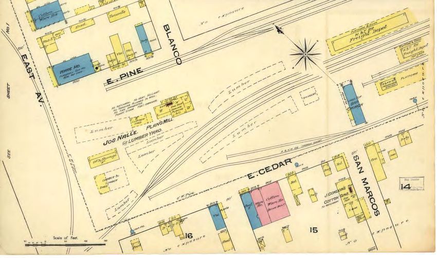
Project Identification

  ▪   Report Completion Date:                      05/06/2022

  ▪   Date(s) of Fieldwork:                        01/14/2022

  ▪   Survey Type:                                 ☐ Windshield ☐ Reconnaissance ☒ Intensive

  ▪   Report Version:                              ☐ Draft ☒ Final

  ▪   Regulatory Jurisdiction:                     ☒ Federal ☐ State

  ▪   TxDOT Contract Number:                       WA57008SH004

  ▪   District or Districts:                       Austin

  ▪   County or Counties:                          Travis

  ▪   Highway or Facility:                         Interstate Highway (I-) 35

  ▪   Project Limits:

                                  ▪    From: U.S. Highway (US) 290 East

                                      ▪     To: US 290 West/State Highway (SH) 71

  ▪   Main CSJ Number                              0015-13-388

  ▪   Report Author(s):                            Katherine Oldberg and Rick Mitchell; Mead & Hunt, Inc.
                                                   (Mead & Hunt)

  ▪   Principal Investigators:                     Rick Mitchell and Emily Pettis, Mead & Hunt

  ▪   List of Preparers:                           Rick Mitchell – Principal Investigator, directed fieldwork and
                                                   research activities, performed quality control for intensive
                                                   survey products, reviewed National Register of Historic
                                                   Places (NRHP) evaluation, prepared effect recommendation.

                                                   Emily Pettis – Principal Investigator, performed quality
                                                   control for intensive survey products, reviewed NRHP
                                                   evaluation and effect recommendation.

                                                   Katherine Oldberg – primary author of intensive survey
                                                   report, prepared NRHP recommendation.

                 Historical Resources Survey Report, Texas Department of Transportation, Environmental Affairs Division
                                                                                                                              4

            istorical Studies Report, Texas Department of Transportation, Environmental Affairs Division                  4
                                                                                                                          4
Lauren Kelly – conducted fieldwork and research, assisted in
                                                    intensive survey report preparation.

                                                    Caroline Bruchman – prepared field survey maps, survey
                                                    report maps, and GIS deliverables.

Area of Potential Effects (APE)

                  ☐ Existing ROW
                  ☐ 150’ from Proposed ROW and Easements
                  ☐ 300’ from Proposed ROW and Easements
                  ☒ Custom: Former Walker Brothers Warehouse, 807 East 4th Street, Travis Central
                  Appraisal District (TCAD) parcel 191640. (Note: The APE for the I-35 Capital Express
                  Central Project reconnaissance Historic Resources Survey Report [HRSR] extends
                  150 feet beyond the project’s Environmental Study Area.)

  ▪     Historic-Age Survey Cut-Off Date:                             1980
  ▪     Study Area                               For the I-35 Capital Express Central Project as a whole, the
                                                 historic resources study area extends 1,300 feet beyond
                                                 proposed new right-of-way (ROW) and easements. Results of
                                                 the overall study area analysis are available in the project’s
                                                 Historic Resources Research Design and reconnaissance-level
                                                 HRSR.

                                                 For purposes of this intensive survey, the historic resources
                                                 study area is limited to the Walker Brothers Warehouse parcel.

Section 106 Consulting Parties

  ▪     Public Involvement Outreach Efforts:
      The proposed project includes ongoing focused Section 106 of the National Historic
      Preservation Act of 1966, as amended (Section 106) public involvement outreach, as well as
      incorporation of historic resources as part of the National Environmental Policy Act (NEPA)
      public involvement process. The Texas Department of Transportation (TxDOT) held a virtual
      Section 106 consulting parties meeting on October 6, 2021, to provide an overview of the
      project, cultural resources management as part of TxDOT’s project development process,
      consulting party opportunities and roles in the Section 106 process, and upcoming historic
      resources survey tasks and schedule. TxDOT will involve consulting parties and other interested
      parties to provide input on potentially historic resources and historic districts in the project APE
      and study area. TxDOT will involve consulting parties throughout the Section 106 process,

                  Historical Resources Survey Report, Texas Department of Transportation, Environmental Affairs Division
                                                                                                                               5

              istorical Studies Report, Texas Department of Transportation, Environmental Affairs Division                 5
                                                                                                                           5
including review of the findings of historic resources investigations and potential mitigation
    activities. Additional Information on Section 106-focused public involvement efforts for the I-35
    Capital Express Central Project is described in the March 2022 reconnaissance-level HRSR.

▪     Identification of Section 106 Consulting Parties:
    The following groups and individuals have been identified as potential consulting parties to
    date:
       • Texas Historical Commission
       • Travis County Historical Commission
       • Preservation Austin
       • Preservation Texas
       • City of Austin Historic Landmark Commission/Historic Preservation Office
       • Six Square Cultural District
       • Black Austin Coalition
       • Austin Area Urban League
       • Black Leaders Collective

▪     Section 106 Review Efforts:
    As noted above, TxDOT held a Section 106 consulting party meeting on October 6, 2021, to
    provide an overview of the project, cultural resources management as part of TxDOT’s project
    development process, consulting party opportunities and roles in the Section 106 process, and
    upcoming historic resources survey tasks and schedule. On December 6, 2021, TxDOT updated
    consulting parties on the in-progress cultural resources investigations via email. TxDOT provided
    another update and outlined upcoming steps in the Section 106 process via email on February
    2, 2022. In this email, TxDOT reminded consulting parties of the opportunity to provide input on
    potentially historic resources in the project APE. Mead & Hunt contacted several consulting
    parties to request additional information in the course of developing the draft HRSR. These
    included:
         • City of Austin Historic Landmark Commission/Historic Preservation Office
         • City of Austin Parks and Recreation Department, Historic Preservation and Tourism
         • Preservation Austin
         • Texas Historical Commission

    TxDOT will continue to involve consulting parties throughout the Section 106 process, including
    review of the findings of historic resources investigations and potential mitigation activities.
    TxDOT will provide the draft reconnaissance and intensive-level HRSRs to all consulting parties
    for review and comment.

▪     Summary of Consulting Parties Comments:
    There have been no consulting party comments regarding the Walker Brothers Warehouse to
    date.

               Historical Resources Survey Report, Texas Department of Transportation, Environmental Affairs Division
                                                                                                                            6

           istorical Studies Report, Texas Department of Transportation, Environmental Affairs Division                 6
                                                                                                                        6
Stakeholders

  ▪     Stakeholder Outreach Efforts:
      In addition to the Section 106 consulting parties, anticipated project stakeholders may include
      property owners, residents, and business owners in and near the project APE; neighborhood
      associations and planning contact teams; other neighborhood and community groups; and
      elected officials. The reconnaissance-level HRSR provides additional information on stakeholder
      outreach for the overall I-35 Capital Express Central Project.

      As part of the intensive survey, Mead & Hunt identified the following additional potential
      stakeholders: Anchor Equities, Ltd., property owner.

  ▪     Identification of Stakeholder Parties:
      Anchor Equities, Ltd.
      3839 Bee Cave Road Suite B-203
      Austin, TX 78746

  ▪     Summary of Stakeholder Comments:
      Mead & Hunt and TxDOT have not contacted Anchor Equities, Ltd. at the time of draft report
      submittal.

Project Setting/Study Area

  ▪     Study Area
      The overall historic resources study area for the I-35 Capital Express Central Project extends
      1,300 feet beyond maximum proposed ROW. For the purposes of this intensive survey, the
      study area is confined to the parcel boundary of the Walker Brothers Warehouse. Parcel data
      obtained through TCAD shows that the property comprises TCAD parcel 191640, which contains
      0.6662 acres.

  ▪     Previously Evaluated Historic Resources
      This property was evaluated by Hardy-Heck-Moore, Inc. (HHM, Inc.) as part of the 2016 East
      Austin Survey (HHM ID 3398) and recommended as individually eligible for the NRHP.

  ▪     Previously Designated Historic Properties
      There are no previously designated historic properties within the intensive survey area.

  ▪     Previously Designated Historic Districts
      There are no previously designated historic districts on this property.

                  Historical Resources Survey Report, Texas Department of Transportation, Environmental Affairs Division
                                                                                                                               7

             istorical Studies Report, Texas Department of Transportation, Environmental Affairs Division                  7
                                                                                                                           7
▪     Historic Land Use
      Sanborn maps show that, prior to construction of the Walker Brothers Warehouse, a shed
      associated with a lumber yard was located on the lot. By 1873 industrial development began
      lining the Houston & Texas Central (H&TC) Railroad corridor, which ran just north of the
      property. Shortly thereafter, the Walker Brothers Warehouse was constructed. The property and
      surrounding lots remained a mix of industrial and residential through the late twentieth century.
      The Walker Brothers Warehouse was used for warehouse storage through the 2010s.

  ▪     Current Land Use and Environment
      The current owner purchased the property in 2014 and converted the space into a hostel,
      business, and an event space/music venue, known as “Native Hostel.” As of early 2022 the
      hostel had been permanently closed.

      The I-35 northbound frontage road borders the property to the west. The Capital Metro Red Line
      rail tracks and large recent commercial and mixed-use developments border it to the north. The
      Austin Metal & Iron Company (Resource 403A-C, 300 Medina Street) and historic-age
      residential properties border it to the east and a courtyard and parking lot borders it to the
      south.

  ▪     Historic Period(s) and Property Types
      The subject property is a c.1880 warehouse that initially served an industrial function and was
      converted to commercial and office space in the late twentieth century. In the early twenty-first
      century it was converted into a hostel, commercial space, and music venue.

  ▪     Integrity of Historic Setting
      The integrity of the historic industrial setting was diminished by the construction of I-35 to the
      west in the early 1960s, which cut through the western portion of the block where additional
      industrial and residential properties had been located. Recent commercial and mixed-use
      development to the north continues to compromise the integrity of the historic setting. Detailed
      integrity information is provided in the NRHP Eligibility Recommendations section below.

Survey Methods

  ▪     Methodological Description
  The intensive survey is in compliance with TxDOT’s latest Environmental Toolkit Standards and
  Historical Studies guidance. A reconnaissance-level survey has been performed for the full
  project corridor between US 290 East and US 290 West/SH 71. This intensive-level investigation
  focused on clarifying the NRHP eligibility of the Walker Brothers Warehouse at 807 East 4th
  Street in East Austin. A map is provided in Appendix D. The historic-age resource was identified
  using available historic maps, atlases, and aerials in combination with field observations. The

                  Historical Resources Survey Report, Texas Department of Transportation, Environmental Affairs Division
                                                                                                                               8

              istorical Studies Report, Texas Department of Transportation, Environmental Affairs Division                 8
                                                                                                                           8
property was evaluated for potential NRHP eligibility applying appropriate regional and thematic
contexts. The historic context was developed using primary and secondary source material.
On behalf of TxDOT ENV, Mead & Hunt performed an intensive survey of the Walker Brothers
Warehouse in January 2022. Field survey for the property included detailed photography and
fieldnotes recorded electronically on tablets. Mead & Hunt did not access the interior of the
building. Survey photographs and field data were used to produce inventory forms for the
historic-age resource (see Appendix C).
▪ Comments on Methods
Investigations include one non-archaeological cultural resources intensive survey, including
photographic documentation and research. Findings of the intensive survey are compiled into
this HRSR completed in accordance with TxDOT’s Documentation Standard: Historical Resources
Survey Report.
Survey Results
▪ Project Area Description
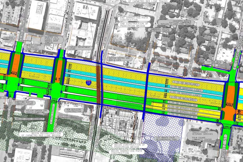
Two alternatives are currently under consideration for the proposed improvements: Alternative 2
and Modified Alternative 3. Under both alternatives, proposed improvements include removing
the existing I-35 upper decks, lowering the roadway, and adding two non-tolled high-occupancy-
vehicle managed lanes in each direction from US 290 East to SH 71/Ben White Boulevard. Both
alternatives would reconstruct frontage roads, ramps, intersections, and east-west cross-street
bridges. Shared-use (pedestrian and bicycle) paths would be added along the corridor. Under
Alternative 2, additional flyovers would be constructed at the I-35 and US 290 East interchange.
Under both alternatives, additional ROW acquisition would be required intermittently along
areas throughout the corridor. In most areas, the proposed new ROW would not extend past the
first tier of parcels adjacent to the existing I-35 ROW. Design files for both alternatives are
available on the project website (www.my35capex.com). Parcels adjacent to the I-35 ROW
include a mix of historic-age and non-historic-age commercial, institutional, or high-density
multi-family residential resources. Several parks, cemeteries, and sports and entertainment
stadiums/arenas are also present. Beyond the first tier of parcels, the APE surveyed for the
project’s reconnaissance HRSR includes a wider mix of resources, including established single-
family residential neighborhoods, a wide range of commercial properties, governmental
buildings, and educational properties.
This intensive survey focuses only on the Walker Brothers Warehouse, located just east of
downtown Austin in East Austin. As noted above, the Walker Brothers Warehouse encompasses
an area bounded by East 3rd Street to the south, Brushy Street to the east, East 4th Street and
the Capital Metro Red Line rail tracks to the north, and the I-35 northbound frontage road to the
west. It is currently occupied by Native Hostel (no longer in operation) and other commercial
Historical Resources Survey Report, Texas Department of Transportation, Environmental Affairs Division
9
istorical Studies Report, Texas Department of Transportation, Environmental Affairs Division 9
9tenants. The immediate surrounding area features large-scale infill properties including
commercial, mixed-use, and residential development.
▪ Literature Review
Mead & Hunt consulted a range of primary and secondary sources to develop the historic
context and reevaluate the subject property for NRHP eligibility. Below is a general description
of sources used and how each informed the intensive survey. Individual resources are also
identified in the References Cited section.
The following secondary sources provided both general background information on the study
area and property-specific information for the historic context:
• Entries from the Handbook of Texas Online.
• Historic contexts on the City of Austin and I-35 previously prepared by HHM, Inc.:
o City of Austin Historic Resources Study, 2016
o Interstate Highway 35 Corridor Historic Resources Investigations, 2004
The following historic mapping and aerial imagery sources obtained online were used to trace
development patterns and land uses in the study area:
• Historic and current aerial imagery obtained through Historicaerials.com, Google Earth,
and U.S. Geological Survey (USGS) Earth Explorer.
• USGS topographic maps of Austin available through USGS TopoView.
• Current property parcel data available from TCAD.
• Historic Sanborn maps obtained through the University of Texas at Austin, Perry-
Castañeda Library Map Collection and the Library of Congress.
• Bird’s-eye maps from the Perry-Castañeda Library Map Collection and Texas Historic Map
Overlay.
Property-specific primary source materials were obtained online and at the Austin History
Center. These materials were used along with other sources to develop a historic overview of
the Walker Brothers Warehouse. These sources included the following:
• Historic photos of the Walker Brothers Warehouse available at the Austin History Center.
• Building permit and inspection records for the Walker Brothers Warehouse available at
the Austin History Center.
Historical Resources Survey Report, Texas Department of Transportation, Environmental Affairs Division
10
istorical Studies Report, Texas Department of Transportation, Environmental Affairs Division 10
10• Issues of the Austin American-Statesman and Austin American available through
Newspapers.com and on the newspaper’s own website.
• Recent local news articles on investors Michael Dickson, Antonio Madrid, and Will
Steakley and Native Hostel, as well as the website for Native Hostel.
• Historic photos from TxDOT Photo Library, City of Austin directories, and U.S. Census
records 1850-1910.
Historical Context Statement
The Railroad and Industrial Development in Austin’s East Outlots
The history of the construction and use of the Walker Brothers Warehouse is tied to the
presence of the railroad tracks running east-west through East Austin and downtown Austin. The
H&TC Railroad was completed through Austin in December 1871 as the city’s first railroad. By
1873 the H&TC continued north of Austin through Dallas to reach Denison at the Oklahoma
border, where it connected with the Missouri, Kansas, and Texas (MK&T) Railroad, providing a
rail connection to St. Louis and the eastern United States and thereby enhancing regional and
interstate commerce and trade.1 In 1883 Southern Pacific bought the H&TC Railroad and it
became a subsidiary of that line.2
The arrival of the H&TC initiated an era of industrial development in Austin along East and West
4th and 5th Streets, which ran to the south and north of the railroad corridor, respectively (see
Figure 1). Warehouses and other industrial and agricultural processing buildings featured rail
sidings that provided direct access to the tracks. The area east of East Avenue extending
several blocks to the north and south of the railroad was known as the east “Outlots.” The 1885
Sanborn map shows the two-story stone Walker Brothers Warehouse (vacant) across from the
H&TC and lumber yards, as well as a feed store, dwellings, and a harness shop to the west, and
a general store, cotton warehouse, two saloons, and a cotton gin to the east (see Figures 2 and
3).3 By 1890 the area became home to a diverse population that included immigrants and
Black freedmen (see Figure 4).4
1 George C. Werner, “Houston and Texas Central Railway,” Handbook of Texas Online, accessed January
27, 2022, https://www.tshaonline.org/handbook/entries/houston-and-texas-central-railway.
2 Michael Barnes, “Austin’s First Railroad Altered the City Forever,” Austin American-Statesman, May 23,
2019, https://www.austin360.com/story/news/history/2019/05/23/on-christmas-day-1871-austins-first-
railroad-altered-city-forever/5079567007/.
3 “Austin, Texas, June 1885,” 1:600 (New York: Sanborn Map & Publishing Company, 1885), Sheet 7,
University of Texas at Austin, Perry-Castañeda Library Map Collection.
4 HHM, Inc., City of Austin Historic Resources Survey: Final Report, Volume I (Prepared for the City of
Austin, October 2016), 16.
Historical Resources Survey Report, Texas Department of Transportation, Environmental Affairs Division
11
istorical Studies Report, Texas Department of Transportation, Environmental Affairs Division 11
11Figure 1. 1873 bird’s-eye view of Austin with the future location of the Walker Brothers
Warehouse highlighted. Note the industrial development along the railroad, the freight depots,
and the lumber yard that dominates the subject block.5
5Augustus Koch, “Bird’s Eye View of the City of Austin, Travis County, Texas, 1873” (Madison, Wis.: J. J.
Stoner, 1873), Perry-Castaneda Library at the University of Texas at Austin.
Historical Resources Survey Report, Texas Department of Transportation, Environmental Affairs Division
12
istorical Studies Report, Texas Department of Transportation, Environmental Affairs Division 12
12Figure 2. 1885 Sanborn map showing industrial development along the H&TC Railroad. The
location of the Walker Brothers Warehouse is highlighted in bright yellow.6
Figure 3. Zoomed-in look at the location of the Walker Brothers Warehouse and its immediate
surroundings on the 1885 Sanborn map. The Walker Brothers Warehouse is shown as 813
East Cedar Street.7
6 “Austin, Texas, June 1885,” Sheet 7.
7 “Austin, Texas, June 1885,” Sheet 7.
Historical Resources Survey Report, Texas Department of Transportation, Environmental Affairs Division
13
istorical Studies Report, Texas Department of Transportation, Environmental Affairs Division 13
13Figure 4. 1890 bird’s-eye view of Austin with the location of the Walker Brothers Warehouse
highlighted. Note the industrial development along the railroad and tenement houses on the
subject block.8
A historic context of Austin developed by HHM, Inc. for the City of Austin in 2016 described the
considerable growth along this corridor in the early twentieth century:
The 1900s’ first quarter saw rapid expansion of the east Outlots with development of many
areas previously unplatted to meet the continuing demand….The year 1904…marked the
arrival of the Missouri, Kansas and Texas Railroad (MK&T or “Katy”) extension from
Granger to Austin. Completed on June 15, 1904, the line tied into the existing track of the
H&TC at the edge of East Austin. The MK&T used the tracks of the H&TC from the MK&T
depot grounds in East Austin to the H&TC passenger depot located downtown for
passenger service.9
The area saw additional rail traffic with the new MK&T line and the surrounding development
continued well into the mid-twentieth century. The 1935 Sanborn map with 1962 updates
shows considerable industrial growth along the railroad east of East Avenue, in the vicinity of
the Walker Brothers Warehouse. The footprint of the subject building today matches the
8 Augustus Koch, “Partial View of Austin, Texas” (Kansas City, Mo.: Inter-State Publishing Company, 1890),
Perry-Castaneda Library at the University of Texas at Austin,
https://maps.lib.utexas.edu/maps/historical/austin-1890-birdseyeaustin_01.jpg.
9 HHM, Inc., City of Austin Historic Resources Survey: Final Report, Volume I, 36–38.
Historical Resources Survey Report, Texas Department of Transportation, Environmental Affairs Division
14
istorical Studies Report, Texas Department of Transportation, Environmental Affairs Division 14
14building depicted on this map, including the c.1935 and c.1953 additions (see Figures 5 and
6).10
Figure 5. 1935 Sanborn map with 1962 updates showing industrial development along the rail
corridor between East 4th and East 5th Streets. The Walker Brothers Warehouse is shown in the
red square with the c.1935 addition on the side (west) and rear (south) elevations, and the
c.1953 addition shown as 807 East 4th Street. Note that I-35 has replaced the dwellings
previously located to the west of the warehouse.11
10“Austin, Texas, 1935 (Revised 1962) Vol. 2.,” 1:600 (New York, 1962), Sheet 211, Digital Sanborn
Maps, 1867-1970, ProQuest.
11 “Austin, Texas, 1935 (Revised 1962) Vol. 2.,” Sheet 211.
Historical Resources Survey Report, Texas Department of Transportation, Environmental Affairs Division
15
istorical Studies Report, Texas Department of Transportation, Environmental Affairs Division 15
15Figure 6. Zoomed-in look at the Walker Brothers Warehouse on the 1935 Sanborn map with
1962 updates. Note the dwellings located to the south of the warehouse. The dwellings were
demolished in the 1980s and that area, which is now part of the legal parcel, is now comprised
of a parking lot, courtyard, and ad-hoc storage."12
Walker Brothers Warehouse, 1880-1890
The Walker Brothers Warehouse first appears in the 1881-1882 Morrison & Fourmy’s General
Directory of the City of Austin.13 Multiple entries include “Walker Bros.” under William B. and
James J. Walker located on Cedar Street (now East 4th Street) between East Avenue (now I-35)
and Blanco Street (now Brushy Street). One of the entries advertised the establishment sold
12“Austin, Texas, 1935 (Revised 1962) Vol. 2.,” Sheet 211.
13Morrison & Fourmy’s General Directory of the City of Austin (Austin, Texas: Morrison & Fourmy, 1881),
166, 167, 186, 188, 189, https://texashistory.unt.edu/ark:/67531/metapth39151/.
Historical Resources Survey Report, Texas Department of Transportation, Environmental Affairs Division
16
16
16“groceries, dry goods, hardware, cotton, wool, and hides.”14 An earlier city directory from 1877-
1878 includes entries for the general merchants, saloons, a carpenter, and druggist on Cedar
Avenue east of the subject property between Blanco Street and San Marcos Street (see Figures
2 and 3). The 1877-1878 directory does not mention a cold storage building or business
between East Avenue (now I-35) and Blanco Street. Residences are listed on Cedar Avenue
between East Avenue and Blanco Street. It is likely the subject two-story stone warehouse was
built between 1877 and 1881 on vacant land or replaced demolished dwellings.15
William Bailey (W.B.) Walker was born in Jackson, Mississippi, on September 8, 1840, and his
younger brother, James J. Walker, was born in 1848 in New Madrid County, Missouri.16 In 1860,
one year before the start of the Civil War, W.B. was 20 and lived with his parents in Lavaca
County, Texas, along with his brothers and sisters.17
Following the Civil War, W.B. moved to Austin in 1871. The Austin city directory from 1872, as
well as an advertisement placed in the November 6, 1872, edition of the Tri-Weekly State
Gazette, list Walker as one of the proprietors of P. Thompson & Co., a merchant company based
out of a building “near the freight depot” (see Figure 7).18 It is likely Thompson and Walker
operated their business out of a building on East Cedar Avenue near the H&TC Railroad freight
depots and east of the future location of the Walker Brothers Warehouse (see Figures 1-4).19
Their advertisement notes trading in products like cotton and wool but does not discuss selling
groceries.
14 Morrison & Fourmy’s General Directory of the City of Austin, 1881, 167.
15 Mooney & Morrison’s General Directory of the City of Austin (Houston, Texas: Mooney & Morrison,
1877), https://texashistory.unt.edu/ark:/67531/metapth46838/; “Austin, Texas, June 1885,” 7.
16 “William B. Walker, Merchant Here for Many Years, Is Dead,” The Austin American, July 25, 1917,
https://www.newspapers.com/image/384497879/?terms=william%20b%20walker&match=1; United States
of America, Bureau of the Census, Seventh Census of the United States, 1850 (Washington, D.C.: National
Archives and Records Administration, 1850), 305, Ancestry.com; United States of America, Bureau of the
Census, The Eighth Census of the United States, 1860 (Washington D.C, 1860), 186, 187,
https://www.ancestry.com/discoveryui-content/view/35054676:7667.
17 United States of America, Bureau of the Census, The Eighth Census of the United States, 1860, 186.
18 Mercantile and General City Directory of Austin Texas -- 1872-73 (Houston, Texas: Gray & Moore, 1872),
110, 126, https://texashistory.unt.edu/ark:/67531/metapth38126/; “Commission Merchants,” Tri-Weekly
State Gazette, n.d., 4, https://texashistory.unt.edu/ark:/67531/metapth181071/m1/4/.
19 “Austin, Texas, June 1885,” Sheet 7.
Historical Resources Survey Report, Texas Department of Transportation, Environmental Affairs Division
17
istorical Studies Report, Texas Department of Transportation, Environmental Affairs Division 17
17Figure 7. Advertisement for the P. Thompson & Co. in the 1872-1873 city directory of Austin,
listing P. Thompson and W.B. Walker as proprietors.20
Sometime between 1872 and 1877 W.B. struck out on his own and opened W.B. Walker & Co.
on Pecan Street (now East 6th Street) between Congress Avenue and Colorado Avenue, which
sold groceries and "provisions.”21 The 1877 Austin city directory lists W. Bailey and James J.
Walker as proprietors of W.B. Walker & Co., which was noted as one of almost 100 grocers in
Austin at that time.22 In the 1881 directory the company appears as the “Walker Bros. (W.B. and
J.J. Walker)” with their store located at 205 Pecan Street, between Brazos and San Jacinto
(extant), and their storage warehouse located at the subject property on Cedar Street between
East Avenue and Blanco Street (now Brushy Street).23
City directories from 1883 to 1903 list W.B. Walker as a grocer with a retail store at 208-210
East 6th Avenue and wholesale grocery at 901-911 East 4th Street, immediately to the east of
the subject property.24 The city directories between 1883 and 1903 do not list James J.,
implying he left the business and Austin sometime between 1882 and 1883. According to city
directories, newspaper ads in The Austin American, the 1910 census, and W.B.’s obituary, he
later changed the name of his store to W.B. Walker & Sons to include his three sons: William
Delaney, James Claire, and Thomas Bailey. W.B.’s obituary states he left the grocery business
and started dabbling in real estate later in life. W.B. died in 1917 at the age of 77 and is buried
20Mercantile and General City Directory of Austin Texas -- 1872-73, 126.
21Mooney & Morrison’s General Directory of the City of Austin, 241.
22 Mooney & Morrison’s General Directory of the City of Austin, 219, 241.
23 Morrison & Fourmy’s General Directory of the City of Austin, 1881, 166, 167, 186, 188.
24 Morrison & Fourmy’s General Directory of the City of Austin (Galveston, Texas: Morrison & Fourmy,
1897), 337, https://texashistory.unt.edu/ark:/67531/metapth39149/.
Historical Resources Survey Report, Texas Department of Transportation, Environmental Affairs Division
18
istorical Studies Report, Texas Department of Transportation, Environmental Affairs Division 18
18at Oakwood Cemetery.25 Review of local newspapers, archives, and online repositories provided
little additional information about James J. Walker.
Walker Brothers Warehouse, 1890s-Present
By 1883 W.B. Walker had moved his business to a different building east of the subject
property. The 1885 Sanborn shows the two-story stone subject building as vacant (see Figures
2-3), and the 1894 Sanborn maps shows the building as “cold storage” (see Figure 8).26 The city
directory from 1897-1898 lists the San Antonio Brewing Association “City brewery” office and
beer vaults at this location, with Philip L. Meyer as agent.27 According to the 2016 evaluation by
HHM, Inc. (HHM ID 3398), the San Antonio Brewing Association resided in the building through
1916.28 Based on the size of the building and its cold storage function, it is likely the subject
building served as a local distribution/storage location for the brewery.
The San Antonio Brewing Association was started in the 1880s by a group of Texans in San
Antonio who bought the J.B. Boehloradsky Brewery (1881-1883). In 1886 the San Antonio
Brewing Association started producing Pearl Beer. Under the leadership of Otto Koehler, the San
Antonio Brewing Association became the largest brewery in Texas by 1916.29 Koehler was
considered one of the wealthiest men in the Southwest, with investments in bank stock, mines,
and real estate, in addition to his involvement in the San Antonio Brewing Association. After
Koehler's death in 1914, ownership of the warehouse transferred to his wife Emma, who also
took over the brewery.30
25 “William B. Walker, Merchant Here for Many Years, Is Dead”; United States of America, Bureau of the
Census, The Thirteenth Census of the United States, 1910 (Washington D.C, 1910),
https://www.ancestry.com/discoveryui-
content/view/28677197:7884?tid=&pid=&queryId=b33a1a305ea20d952bc5659099f3a3b6&_phsrc=vMS8
57&_phstart=successSource.
26 “Austin, Travis County, Texas, January 1894,” 1:600 (New York: Sanborn-Perris Map Company, 1894),
Sheet 20, University of Texas at Austin, Perry-Castañeda Library Map Collection.
27 Morrison & Fourmy’s General Directory of the City of Austin, 1897, 220.
28 HHM, Inc., City of Austin Historic Resources Survey: Final Report, Volume IV (Prepared for the City of
Austin, October 2016), 44.
29 Mike Hennech, “The Business of Brewing,” Heritage Magazine, 2005, 21, Portal to Texas History,
https://texashistory.unt.edu/ark:/67531/metapth45370/.
30 Hennech, “The Business of Brewing,” 21–22; Michael C. Hennech, “Pearl Brewing Company,” Texas
State Historical Association Handbook of Texas, n.d., https://www.tshaonline.org/handbook/entries/pearl-
brewing-company; Michael C. Hennech and Tracé Etinenne-Gray, “Brewing Industry,” Texas State Historical
Association Handbook of Texas, n.d., https://www.tshaonline.org/handbook/entries/brewing-industry. In
1952, SABA changed its name to Pearl Brewing Company. Today Pabst Brewing Company contracts with Miller
Brewing Company to make Pearl beer.
Historical Resources Survey Report, Texas Department of Transportation, Environmental Affairs Division
19
istorical Studies Report, Texas Department of Transportation, Environmental Affairs Division 19
19Figure 8. 1894 Sanborn map showing the Walker Brothers Warehouse as “cold storage,” as
well as the lot numbers for block 16 of division O. The Walker Brothers Warehouse is
highlighted in yellow and the current parcel boundary is highlighted in blue.31
Newspaper records of real estate transactions published in 1918 indicate the San Antonio
Brewing Association sold multiple parcels to “Ella Koehler,” including lots 11 and 12, block 16
in division O, outlot 1 in January 1916.32 This legal description matches the lot containing the
original two-story stone warehouse building (lot 11), as well as the lot immediately to the west
(lot 12) that would later include the c.1935 addition, the first of two additions to the side (west)
elevation of the building (the addition c.1953 takes over lots 13 and 14) (see Figure 8). It is
likely the newspaper misprinted Emma Koehler’s name, as deed records filed in 1918 confirm
the transaction between San Antonio Brewing Association and Emma Koehler.33
31 “Austin, Travis County, Texas, January 1894,” Sheet 20.
32 “Real Estate Transfers,” The Statesman, March 5, 1918, Newspapers.com.
33 “Deed, San Antonio Brewing Association to Emma Koehler,” March 4, 1918, Vol. 302, Page 429A,
Register of Deeds Office, Travis County, Texas.
Historical Resources Survey Report, Texas Department of Transportation, Environmental Affairs Division
20
istorical Studies Report, Texas Department of Transportation, Environmental Affairs Division 20
20In 1918 Emma Koehler sold the property to Theo P. Meyer, son of San Antonio Brewing
Association Austin agent Philip L. Meyer.34 According to the HHM, Inc. 2016 survey of the
property, Witcher Produce Company and Purina Feed Store were located in the warehouse
building in 1920.35 In 1922 Meyer sold the property to Charles J. Martin, who then deeded it to
his business—C.J. Martin & Sons—in 1924.36 C.J. Martin & Sons, a merchant supply company
selling a variety of items including seeds, insecticide, veterinary supplies, and sanitary
chemicals, operated its factory and warehouse out of the building until the 1950s.37 Charles J.
founded the business in 1883 and ran the company with his sons Charles Early and Leo Martin.
From the 1920s through the 1940s their retail store was located at 112-118 East 4th Street
(East 4th Street and Chicon Street, nonextant), west of the subject property (see Figure 9).38
34 “Deed, Emma Koehler to Theo P. Meyer,” March 15, 1918, Vol. 155, Page 307, Register of Deeds
Office, Travis County, Texas; “Philip Louis Meyer - Find A Grave Memorial,” n.d.,
https://www.findagrave.com/memorial/68515499/phillip-louis-meyer.
35 HHM, Inc., City of Austin Historic Resources Survey: Final Report, Volume IV, 44.
36 “Deed, Theo P. Meyer to C.J. Martin,” October 14, 1922, Vol. 343, Page 615A, Register of Deeds Office,
Travis County, Texas; “Deed, C.J. Martin to C.J. Martin & Sons,” February 26, 1924, Vol. 359, Page 319,
Register of Deeds Office, Travis County, Texas.
37 HHM, Inc., City of Austin Historic Resources Survey: Final Report, Volume IV, 44; “Certificate of Death for
Charles J. Martin” (Texas State Board of Health, August 15, 1926), Ancestry.com,
https://www.ancestry.com/discoveryui-
content/view/30255485:2272?tid=&pid=&queryId=dae45b26cde1e8381d847aed84be29d3&_phsrc=vMS8
48&_phstart=successSource; “Certificate of Death for Charles Early Martin” (Texas State Board of Health, June
19, 1956), Ancestry.com, https://www.ancestry.com/discoveryui-
content/view/21615447:2272?tid=&pid=&queryId=dae45b26cde1e8381d847aed84be29d3&_phsrc=vMS8
48&_phstart=successSource; “World War I Draft Registration Card for Charles Early Martin,” June 5, 1917,
Ancestry.com, https://www.ancestry.com/discoveryui-
content/view/17813959:6482?tid=&pid=&queryId=dae45b26cde1e8381d847aed84be29d3&_phsrc=vMS8
48&_phstart=successSource.
38 Polk’s Morrison & Fourmy Austin City Directory (Austin, Texas: Morrison & Fourmy Directory Co., Inc.,
1924), 103, 325,
https://www.ancestry.com/imageviewer/collections/2469/images/5017747?usePUB=true&_phsrc=vMS851
&_phstart=successSource&usePUBJs=true&pId=404187596; “Leo Martin Last Rites Set Today,” The Austin
American, January 21, 1957, Newspapers.com.
Historical Resources Survey Report, Texas Department of Transportation, Environmental Affairs Division
21
istorical Studies Report, Texas Department of Transportation, Environmental Affairs Division 21
21Figure 9. An advertisement for C.J. Martin & Sons in the 1924 Austin city directory. Note the
factory address of 815 East 4th Street, a former street number matching the current location of
the subject property at 807 East 4th Street.39
According to TCAD assessor records, an addition was built on the west and south elevations of
the building in 1937. However, the one-story frame addition appears on the 1935 Sanborn map
(see Figure 10), which shows the original two-story stone building as a chemical compound
storage building. It is likely the addition was built to meet the storage needs of the growing and
flourishing C.J. Martin & Sons business. The addition appears in historic aerials from 1952 (see
Figure 11).
Charles J. Martin died in 1926 and his sons continued to run the business until the late 1940s,
when they sold the company to Werner J. Perlitz.40 By 1952 C.J. Martin & Sons had vacated the
building and Cabaniss Furniture Company had moved in.41 The Cabaniss Furniture Company
was founded in 1920 by Charles M. Cabaniss and John Wall. Within a few months Wall sold his
interest in the company to Cabaniss’s nephew, Bert L. Cabaniss, and J.S. (Steen) Brown.42
According to a newspaper article published in The Austin American on October 18, 1953,
Cabaniss was “one of the largest furniture firms in this section of the Southwest.”43 This same
article describes the company as having its main show room located at 200-204 East 6th Street
(extant), a warehouse salesroom at San Jacinto Boulevard and East 5th Street, a used furniture
store known as Brown Furniture Company at 218 East 6th Street (extant), and their warehouse
39 Polk’s Morrison & Fourmy Austin City Directory, 1924, 103.
40 “Werner J. Perlitz,” Austin American-Statesman, December 12, 1993, Newspapers.com.
41 HHM, Inc., City of Austin Historic Resources Survey: Final Report, Volume IV, 44.
42 “Cabaniss Tells of Ways to Win Home Tour Contests,” The Austin Statesman, May 2, 1931,
Newspapers.com; “Cabaniss-Brown Shows Growth in 3rd Century,” The American-Statesman, October 18,
1953, Newspapers.com.
43 “Cabaniss-Brown Shows Growth in 3rd Century.”
Historical Resources Survey Report, Texas Department of Transportation, Environmental Affairs Division
22
istorical Studies Report, Texas Department of Transportation, Environmental Affairs Division 22
22located at East 4th Street and Brushy Street (the subject property). At the time the article was
published, the company was constructing a new addition to the warehouse, doubling its floor
space (see Figures 12 and 13). The new addition, located on the west side of the c.1935
addition, would allow the San Jacinto Boulevard and East 5th Street location to operate as a
salesroom only.44
Figure 10. 1935 Sanborn map showing the Walker Brothers Warehouse (highlighted in yellow)
with the one-story, frame, c.1935 addition on the side (west) elevation. Note the median from
East Avenue (now I-35).45
44“Cabaniss-Brown Shows Growth in 3rd Century.”
45“Austin, Texas, 1935 Vol. 1.,” 1:600 (New York: Sanborn Map Company, 1935), Sheet 211, Library of
Congress, https://www.loc.gov/item/sanborn08415_006/.
Historical Resources Survey Report, Texas Department of Transportation, Environmental Affairs Division
23
istorical Studies Report, Texas Department of Transportation, Environmental Affairs Division 23
23Figure 11. The Walker Brothers Warehouse in September 1952. Note the c.1935, one-story
addition around the original two-story building and East Avenue to the west.46
46United States Geological Survey, “Aerial Image 1XF0000010104” (Department of Interior, US Geological
Survey, September 28, 1952), earthexplorer.usgs.gov, https://earthexplorer.usgs.gov/.
Historical Resources Survey Report, Texas Department of Transportation, Environmental Affairs Division
24
istorical Studies Report, Texas Department of Transportation, Environmental Affairs Division 24
24Figure 12. This December 1959 photo shows the Cabaniss Furniture Company in the building
(red arrow). Note the demolition of the single-family homes to the southwest of the warehouse
in preparation of I-35 construction, as well as the East Avenue median in the foreground.47
Figure 13. Zoomed-in version of the December 1959 photograph in Figure 12. Note the original
two-story, c.1880 building highlighted in blue, the c.1935 addition highlighted in grey, and the
c.1953 one-story addition highlighted in purple.48
47 Texas Department of Transportation, IH 35 Construction at East 4th Street, December 1959, TxDOT
Photo Library.
48 Texas Department of Transportation, IH 35 Construction at East 4th Street.
Historical Resources Survey Report, Texas Department of Transportation, Environmental Affairs Division
25
istorical Studies Report, Texas Department of Transportation, Environmental Affairs Division 25
25In 1962 the warehouse was vacant, according to the HHM, Inc. 2016 survey. By the late 1960s
the Pool Transfer & Storage Company, Inc. occupied it (see Figures 14-18).49 Pool Transfer &
Storage Company was founded in Austin in the 1910s by Alfred Houston Pool. After his death in
1932, his son Hill Houston (H.H.) became instrumental in continuing the business. In addition to
acting as agents of the Global Van Lines, Pool Transfer & Storage Company held auctions at the
subject property, often auctioning seized property it moved to the warehouse when the owners
of the property did not pay the necessary fines to keep their possessions. The company also
held auctions of goods like television sets and Persian rugs at the subject property.50 By 1973
H.H. acquired the lots to the south of the subject property with the single-family homes that
would later become a courtyard, ad-hoc storage, and a parking lot.51 Although it is unknown
when Bert L. Cabaniss purchased the lots to the north that include the subject property, Travis
County Clerk and Recorder records indicate Cabaniss sold the property to H.H. Pool, H.H. Pool,
Jr., and H.H. Pool’s son-in-law James J. Stahl in 1983.52 I-35 was constructed through this area
along former East Avenue in the early 1960s. By the time of the 1962 Sanborn map update
(see Figures 5 and 6), the highway was in place and several buildings and structures had been
removed to make way for the frontage road, including the houses formerly located on the
western portion of the 800 block of East 4th Street and buildings southwest of the Walker
Brothers Warehouse, including a “Mexican Baptist Church.”53
49 HHM, Inc., City of Austin Historic Resources Survey: Final Report, Volume IV, 44.
50 “LOST,” Austin Daily Statesman, February 17, 1915, sec. Classified, Newspapers.com; Polk’s Morrison
& Fourmy Austin City Directory (Austin, Texas: Morrison & Fourmy Directory Co., Inc., 1922), 537,
https://texashistory.unt.edu/ark:/67531/metapth39153/m1/5/; “World War I Draft Registration Card for
Alfred Houston Pool,” September 12, 1918, Ancestry.com, https://www.ancestry.com/discoveryui-
content/view/17814878:6482; “Alfred Houston Pool,” Austin American, June 1, 1932, Newspapers.com,
https://www.newspapers.com/image/385909442/; “Auction Notice,” Austin Statesman, July 12, 1968,
Newspapers.com; “Auction,” Austin American-Statesman, August 16, 1979, Newspapers.com; “H.H. ‘Buster’
Pool,” Austin American-Statesman, July 31, 1994, sec. Deaths and funerals, Newspapers.com.
51 “Deed, H.H. Pool et al and Hazel Pool et Al,” April 11, 1997, Vol. 12925, Page 00167, Register of Deeds
Office, Travis County, Texas; “Deed, Hazel Pool et al and Katie Rose Investments LTD,” August 3, 1998, Vol.
13238, Page 02436, Register of Deeds Office, Travis County, Texas.
52 “Release of Lien between Bert L. Cabaniss and H.H. Pool, H.H. Pool, Jr., and James J. Stahl,” June 6,
1983, Vol. 8114, Page 92, County Clerk Web Search, Travis County, Texas; “H.H. ‘Buster’ Pool.”
53 “Austin, Texas, 1935 Vol. 1.,” Sheet 211.
Historical Resources Survey Report, Texas Department of Transportation, Environmental Affairs Division
26
istorical Studies Report, Texas Department of Transportation, Environmental Affairs Division 26
26Figure 14. This 1971 photo of the Walker Brothers Warehouse shows the original two-story
stone building and the part of the c.1935 addition on the west side of the original c.1880
building. Note the changes to the fenestration on the front (north) facade.54
Figures 15 and 16. 1980 photographs of the Walker Brothers Warehouse front (north) facade
and details of the entry on the front facade.55
54 Carl [Horzberger], HB - 4th E. 807, Photograph, black & white, 1971, Austin History Center.
55 Historic Property, Photograph THC_06-0245, Photograph, black & white, April 27, 1980, The Portal to
Texas History, https://texashistory.unt.edu/ark:/67531/metapth677100/; Historic Property, Photograph
THC_06-0244, Photograph, black & white, April 27, 1980, The Portal to Texas History,
https://texashistory.unt.edu/ark:/67531/metapth676746/.
Historical Resources Survey Report, Texas Department of Transportation, Environmental Affairs Division
27
istorical Studies Report, Texas Department of Transportation, Environmental Affairs Division 27
27Figures 17 and 18. 1980 photographs of the Walker Brothers Warehouse front (north) facade
and side (east) elevation.56
The owners of Pool Transfer & Storage owned the building and the parcel to the south until they
combined the parcels and sold the property to Katie Rose Investments in 1998. In 2004
Cothron Safe & Lock Company purchased the property. Cothron Safe & Lock was located there
until Anchor Equities, Ltd. purchased the property in 2014.57 Under Anchor Equities’ ownership,
the building hosted a variety of businesses, including a hostel in the original two-story stone
building; and an event space, coffee shop, bar, café, music venue, and tattoo parlor in the two
additions.58 The exterior of the additions also have periodically changing murals painted by
various artists, including local Austinites Sophie Roach in 2018, Mylo Mendez in 2020, Chris
Rogers in 2021, and Sarah Wilson in 2021.59 Currently the additions are host to murals by
artists Mylo Mendez, Chris Rogers, Sarah Wilson, and Brooklyn-based artist Jason Naylor.60
56 Historic Property, Photograph THC_06-0242, Photograph, black & white, April 27, 1980, The Portal to
Texas History, https://texashistory.unt.edu/ark:/67531/metapth676023/; Historic Property, Photograph
THC_06-0243, Photograph, black & white, April 27, 1980, The Portal to Texas History,
https://texashistory.unt.edu/ark:/67531/metapth673245/.
57 “Deed, H.H. Pool et al and Hazel Pool et Al”; “Deed, Hazel Pool et al and Katie Rose Investments LTD”;
“Deed, Katie Rose Investments LTD and Cothron Safe & Lock Company Inc.,” August 3, 1998, Instrument No.
2004096418TR, Register of Deeds Office, Travis County, Texas; “Deed, Cothron Safe & Lock Company Inc. and
Cothron Land & Cattle Co LP,” December 17, 2013, Instrument No. 2013226988TR, Register of Deeds Office,
Travis County, Texas; “Deed, Cothron Land & Cattle Co LP and Anchor Equities LTD,” January 10, 2014,
Instrument No. 2014005392TR, Register of Deeds Office, Travis County, Texas.
58 “A New Way to Experience Hospitality,” Native, n.d., https://nativehostels.com/.
59 @nativehostel, “The Process,” Social Media, Instagram, (July 17, 2018),
https://www.instagram.com/p/BlVdowVjcbN/; “About,” Sophie Roach, n.d., https://sophieroach.com/about;
“Native Hostel,” Sophie Roach, 2018, https://sophieroach.com/native-hostel-mural; Hank Cavagnaro, “Austin
Muralist Honoring Essential Women Workers with Art around the City,” KVUE, February 1, 2022,
https://www.kvue.com/article/news/community/austin-muralist-essential-women-workers-art/269-e9f5d01c-
254f-48c9-ad59-3a74244cea83?msclkid=113884d4aeb211ecb6989340b226e716; “About Sarah,” Sarah
Wilson Photography, n.d., http://www.sarahwilsonphotography.com/about-sarah; @handmademendez,
“Repost from @fbairprogram,” Social Media, Instagram, (November 13, 2020),
https://www.instagram.com/p/CHjDQqElW6C/; “About,” Chris Rogers Art, 2020,
https://www.chrisrogersartist.com/about; @chrisrogersart, “#Repost @npr @KUTX Examines the Impact of
Austin’s Racial Justice Protests Inspired by George Floyd’s Death,” Social Media, Instagram, (February 15,
2021), https://www.instagram.com/p/CLVaqJYFoOc/.
60 “Creatively Positive X Positively Creative,” Jason Naylor, 2020, https://jasonnaylor.nyc/about.
Historical Resources Survey Report, Texas Department of Transportation, Environmental Affairs Division
28You can also read