GUNAIKURNAI AND VICTORIAN GOVERNMENT JOINT MANAGEMENT PLAN - LAKE TYERS STATE PARK - KRAUATUNGALUNG COUNTRY - Gunaikurnai Land and Waters ...
←
→
Page content transcription
If your browser does not render page correctly, please read the page content below
GUNAIKURNAI
     AND  VICTORIAN  GOVERNMENT
        JOINT  MANAGEMENT  PLAN

                  LAKE  TYERS  STATE  PARK
       —  KRAUATUNGALUNG  COUNTRY

Authorised and published by the Gunaikurnai Traditional Owner Land Management Board (GKTOLMB) 574 Main Street, Bairnsdale VIC 3785. Copyright © Gunaikurnai Traditional Owner Land Management Board and State of Victoria 2018. This publication is copyright. No part may be reproduced or transmitted by any process except in accordance with the provisions of the Copyright Act 1968. For further information, visit the GKTOLMB website at www.gunaikurnai.com.au Copies of the complete Joint Management Plan can be downloaded from the GKTOLMB website or obtained from the Board’s office, 574 Main Street, Bairnsdale. National Library of Australia Cataloguing-‐in-‐Publication entry Gunaikurnai and Victorian Government Joint Management Plan. Lake Tyers State Park — Krauatungalung Country. Gunaikurnai Traditional Owner Land Management Board. ISBN 978-‐0-‐6483380-‐4-‐8 (PDF version) Note: Page numbering in this plan is consistent with page numbering in the complete Gunaikurnai and Victorian Government Joint Management Plan. Disclaimer This document does not limit the operation or exercising of Native Title or Traditional Owner rights held by the Gunaikurnai people. Every effort has been made to ensure that the information in this document is accurate. The Board does not guarantee that the publication is without flaw of any kind and therefore disclaims all liability for any error, loss or consequence that may arise from you relying on any information in the publication. The Board acknowledges that there are differing views about the meaning and spelling of some Gunaikurnai words, and recognise that these may change in the future. The same applies to the telling and meaning of Gunaikurnai mythological stories. Where Gunaikurnai language or stories are used in this plan, the spelling or story contained in the Gunaikurnai Land and Waters Aboriginal Corporation Gunaikurnai Whole-‐of-‐Country Plan (2015) has been adopted for the purpose of consistency. Quotations included in this plan are reproduced verbatim, including spelling, punctuation and capitalisation. These may differ from the style adopted in this plan. Parks Victoria Act 2018 References to Parks Victoria in this plan should be read in the following context: The Parks Victoria Act 2018 (Vic.) will commence later in 2018. Under this Act, Parks Victoria will change from being an authority providing park management services by agreement to being an authority with park and reserve management responsibilities in its own right. It will continue to be a Committee of Management of particular reserves under the Crown Land (Reserves) Act 1978 (Vic.). Acknowledgements This plan was prepared with assistance from Chris Halstead and Penny Spoelder of TRC Tourism, Simon Faivel and Jonathan Finighan of SVA Consulting, and Brian Doolan of Montane Planning, with input from GKTOLMB members and staff, and partner organisations: Gunaikurnai Land and Waters Aboriginal Corporation, Parks Victoria and Department of Environment, Land, Water and Planning. The Board thanks the following people for providing photographs and images for the overall Joint Management Plan: Alfie Hudson, Bradley Hood, Alice Hughes/Pepper, Robbie Farnham, Sean Phillipson, Jessica Shapiro, Rob Willersdorf, David Meagher.

Lake Tyers State Park — Krauatungalung Country
Bung Yarnda (Lake Tyers) was an important meeting place for Gunaikurnai groups throughout
the area. It was a neutral place that was rich in food and materials. It is the place our mob
lived when we were forcibly removed from our homelands by European settlers. The
catchment area surrounding the Lake Tyers mission is also very significant to us. Our ancestors
often passed through this bushland to get to and from Bung Yarnda, as we continue to do
today. The catchment area is where a lot of our mob lived, camped and fished. It is an
abundant place providing us with food all year round. And it is a beautiful place — you can see
why the old fellas went there… there are many recorded sites — scar trees, artefact scatters,
birthing places and burial sites. Burnt Bridge Reserve is a popular gathering place and ochre
site… The Lake Tyers State Park is a clear example of where the meaning and value of an
important place can’t be divorced from its neighbouring areas.
— Gunaikurnai Whole-‐of-‐Country Plan (GLaWAC 2015)
ii GUNAIKURNAI AND VICTORIAN GOVERNMENT JOINT MANAGEMENT PLAN 
CONTENTS

1   INTRODUCTION  ......................................................................................................................................  122

      1.1   Basis  of  the  management  plan  ...........................................................................................................  122

      1.2   How  to  read  the  plan  ..........................................................................................................................  123

      1.3   The  park  ..............................................................................................................................................  123

2   LAKE  TYERS  STATE  PARK  UNDER  JOINT  MANAGEMENT  .........................................................................  124

3   ZONING  ...................................................................................................................................................  125

4           CARING  FOR  COUNTRY  ...........................................................................................................................  127

      4.1   Gunaikurnai  cultural  heritage  .............................................................................................................  127

      4.2   Land  and  water  values  ........................................................................................................................  128

      4.3   Historic  heritage  .................................................................................................................................  131

      4.4   Threats  to  Country  and  heritage  ........................................................................................................  131

      4.5   Conservation  strategies  to  deal  with  threats  .....................................................................................  133

5   PEOPLE  IN  THE  PARK  ...............................................................................................................................  135

      5.1   Traditional  Owners  connecting  with  Country  .....................................................................................  135

      5.2   Visitors  to  the  park  .............................................................................................................................  135

      5.3   Visitor  strategies  .................................................................................................................................  136

6   WORKING  TOGETHER  .............................................................................................................................  140

      6.1   The  joint  management  delivery  partners  —  GLaWAC,  Parks  Victoria,  DELWP,  GKTOLMB  ................  140

      6.2   Community  and  other  partners  ..........................................................................................................  140

      6.3   Authorised  uses  ..................................................................................................................................  141

      6.4   Park  boundaries  ..................................................................................................................................  141

7   GOALS  AND  ACTIONS  ..............................................................................................................................  142

8   PLAN  MONITORING  AND  REVIEW  ..........................................................................................................  145

REFERENCES  ..................................................................................................................................................  147

LAKE TYERS STATE PARK — KRAUATUNGALUNG COUNTRY iv 
1 INTRODUCTION
1.1 BASIS OF THE MANAGEMENT PLAN
In a 2010 Native Title Determination, the Federal Court recognised that the Gunaikurnai hold native
title rights over much of Gippsland.
At the same time, the Victorian Government took additional steps to recognise Gunaikurnai peoples’
traditional rights and ownership and entered into a Recognition and Settlement Agreement (RSA)
under the Traditional Owner Settlement Act 2010 (Vic.) with Gunaikurnai Land and Waters Aboriginal
Corporation. The Recognition Statement from the RSA is reproduced in full in the Strategic Plan.
The Gunaikurnai Land and Waters Aboriginal Corporation (GLaWAC) is the ‘traditional owner group
entity’ for the purposes of the RSA. GLaWAC is also the Prescribed Body Corporate for the purposes of
the Native Title Act 1993 (Cwlth) and the Registered Aboriginal Party for the area for the purposes of
the Aboriginal Heritage Act 2006 (Vic.).
As part of the RSA, Lake Tyers State Park has been granted to the Gunaikurnai as ’Aboriginal Title’ by
the Victorian Government and will be managed jointly by Gunaikurnai and the Victorian Government.
The Aboriginal Title grant is subject to the Gunaikurnai giving the State the right to occupy, use,
control and manage the land for the same purpose as applied immediately before the grant. In the
case of Lake Tyers State Park, the land continues to be managed as a state park under the National
Parks Act 1975 (Vic.).
This Management Plan for Lake Tyers State Park has been prepared under Section 82 of the
Conservation, Forests and Lands Act 1987 (Vic.) and the provisions of the Gunaikurnai Traditional
Owner Land Management Agreement 2010. It is consistent with the objects and requirements of the
National Parks Act 1975 and the requirements of the Regulations made under that Act. (Additional
legislation and policies that have been considered in the preparation of the Management Plan are
listed in Appendix 4 of the Strategic Plan.)
Because Lake Tyers State Park is within the area covered by the 2010 Determination and the RSA, the
rights of the Gunaikurnai to undertake traditional activities apply to the park. Existing rights and
interests in the park that are held by others are not affected by the Agreement, but remain subject to
management policies and regulation.
The Gunaikurnai Traditional Owner Land Management Board (GKTOLMB) has been established in
accordance with the RSA between GLaWAC and the State with the statutory objective of enabling the
knowledge and culture of the Gunaikurnai to be recognised in the management of the 10 Aboriginal
Title areas, including Lake Tyers State Park. The Board was responsible for preparing this management
plan jointly with GLaWAC, Parks Victoria and the Department of Environment, Land, Water and
Planning (DELWP).
There have been few opportunities in the past for Gunaikurnai to participate in the decision-‐making
and management of public land. Through this management plan, GLaWAC and the Victorian
Government seek to:
• ensure that Lake Tyers State Park is well managed, its values and assets are protected and
conserved, and the statutory requirements for park management are fulfilled, through an equitable
partnership between the Victorian Government and GLaWAC;
• increase opportunities for Gunaikurnai people to connect with country, foster employment and
economic development opportunities and build their capacity and skills to take a central role in
joint management with the other management partners;
• benefit the Gunaikurnai and the State, by recognising, valuing, promoting and incorporating
Gunaikurnai culture, knowledge, skills and decision-‐making into the park.
122 GUNAIKURNAI AND VICTORIAN GOVERNMENT JOINT MANAGEMENT PLAN 1.2 HOW TO READ THE PLAN
This plan provides a description of joint management strategies and actions that are specific to Lake
Tyers State Park. The following sections provide:
• a description of values, uses and threats relating to the land, water and heritage of the park, and
goals and strategies to protect and conserve those values
• a description of Traditional Owner, visitor and community connections to the park and their uses
and activities; and goals and strategies for managing and enhancing those connections and uses;
identification of government and community relationships and partnerships that are key to
managing the park
• an integrated statement of the actions that will be undertaken over the next 10 years to achieve
the goals and implement the strategies described in the plan.
In addition to the specific actions for Lake Tyers State Park in this plan, the strategic initiatives for joint
management described in the Strategic Plan may include actions that relate to Lake Tyers State Park.
The Parks Victoria Act 2018 (Vic.) will commence later in 2018. Under this Act, Parks Victoria will
change from being an authority providing park management services by agreement to being an
authority with park and reserve management responsibilities in its own right. It will continue to be a
Committee of Management of particular reserves under the Crown Land (Reserves) Act 1978 (Vic.).
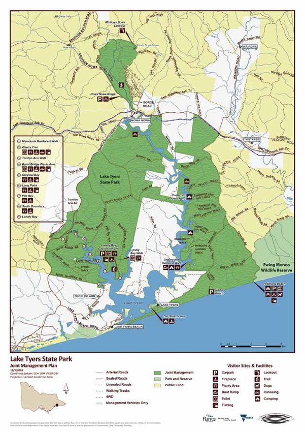
1.3 THE PARK
Lake Tyers State Park is about 20 kilometres north-‐east of Lakes Entrance and comprises 8680 hectares
of land, extending from Lake Tyers Beach to Mount Nowa Nowa.
The park was proclaimed in 2012 on land that had largely been previously reserved under the Forests
Act 1958 (Vic.) as a forest park. It consists of undulating, densely forested country surrounding two
tidal estuaries, the Toorloo Arm and the Nowa Nowa Arm, as well as a narrow spit of land between the
Lake and Bass Strait. Additional land was added to the park in 2014.
The park borders substantial areas of private land on the western side of the Nowa Nowa Arm,
including the Lake Tyers Aboriginal Reserve, which is owned by the Lake Tyers Aboriginal Trust. The
western and eastern boundaries of the park border State forest.
LAKE TYERS STATE PARK — KRAUATUNGALUNG COUNTRY 123 2 LAKE TYERS STATE PARK UNDER JOINT
MANAGEMENT
This joint management plan is the first management plan prepared for the park since its proclamation
in 2012. The Plan reflects both the new arrangements and goals of joint management, as well as the
change in legislated objectives for the park under the National Parks Act.
Lake Tyers has long been an important place for the local community and for visitors especially for
fishing, boating and camping in a forested setting. It is highly accessible to Lakes Entrance, Bairnsdale
and travellers along the Princes Highway but feels remote and natural. A large array of important bird
species and other animal and plant species inhabit the waters, forest, dunes and rainforest of this
special place. The richness of the land and water underpinned the use and occupation of the park by
Gunaikurnai.
In more recent times recreational use of the park has been intensive and relatively informal with
numerous vehicle tracks, camping areas and minimal facilities. That pattern of use has brought
problems including off-‐road driving, uncontrolled boat launching and camping on the shoreline of the
Lake in both the park and on the land of the adjacent Lake Tyers Aboriginal Trust, as well as rubbish
dumping and other impacts.
Lake Tyers is on the Country of the Krauatungalung clan. The Gunaikurnai Whole-‐of-‐Country Plan
(GLaWAC 2015) sets out the following management priorities for Lake Tyers State Park:
• reducing public access points to the river
• undertaking compliance activities in the park to protect significant and vulnerable sites
• planning and developing sustainable use areas, including building playgrounds in the park
• working with authorities to help manage for sustainable fisheries
• clarifying resource extraction rights including firewood for Traditional Owners
• developing an agreement for the many significant areas that lie just outside the (Aboriginal Title)
area.
While recognising these priorities, this management plan sets out actions that are consistent with and
limited to the terms of the 2010 Recognition and Settlement Agreement.
The plan aims to ensure that Lake Tyers State Park continues to be a place for many visitors to enjoy
for camping, fishing, boating, walking and sightseeing, but to reduce the impacts of that use on the
land, water and cultural heritage of the park. To achieve this, the design and quality of visitor areas
and facilities will be improved, and vehicle access and boat launching will be controlled in sensitive
areas.
The plan also emphasises the broader landscape of Lake Tyers especially the links between the park,
the Lake Tyers Trust Land and Nowa Nowa township. Lake Tyers, the place not just the park, is a very
significant location in the history of Victoria and the interaction between Aboriginal and non-‐
Aboriginal people. The plan aims to conserve, interpret and promote these links.
124 GUNAIKURNAI AND VICTORIAN GOVERNMENT JOINT MANAGEMENT PLAN 3 ZONING
A zoning scheme has been developed to provide a geographic framework to manage the park. These
zones will:
• communicate to the community and stakeholders which management aims have priority in
different parts of the park
• indicate the types and levels of use allowed
• assist in minimising conflicts between uses, or between those and the protection of conservation
values
• provide a basis for assessing the suitability of future activities and use proposals.
The location of the zones is shown on Map 1, and their purposes are described in Table 1. Much of the
park between Toorloo Arm and Now Nowa township, (and adjacent to the Lake Tyers Aboriginal Trust
land) is designated within the Conservation Zone in recognition of important vegetation communities
and its cultural heritage as an area traditionally used by Gunaikurnai people living at the Mission and
Reserve. The coastal dunes and hinterland vegetation parallel to Gibbs Beach in the south of the park,
and the core areas of the section of the park north of Nowa Nowa township are also designated in this
zone, to provide protection of their significant natural values.
The areas west of Toorloo Arm, including Burnt Bridge and Cherry Tree Creek day visit sites, are
designated within the Conservation and Recreation Zone. Popular visitor areas on the east side of the
Nowa Nowa Arm are also designated with this zone, including camping areas adjacent to the Arm,
Lake Tyers, The Glasshouse and Pettmans Beach, as are key visitor areas in the northern section of the
park. A key action in the plan is the development of a Camping and Access Strategy for the park. The
zoning in this plan provides guidance for that Strategy based on the current pattern of access, use and
facilities.
The strategy may identify the need for changes in access, activities and facilities that requires the
zoning to be modified in certain locations through a future variation to this plan. Any variation to the
zoning will be subject to community consultation.
Table 1: Management Zones, Lake Tyers State Park.
Zone Description and purpose
Conservation and Areas where the management emphasis is on protection of land, water,
Recreation Zone ecological and cultural values while encouraging dispersed recreation and
nature-‐based tourism.
Low-‐impact recreation activities are allowed; dispersed, small-‐scale facilities are
provided, without significant impact on natural processes and landscape
character.
Recreation Small areas with a high-‐level of visitor facility development catering for a high
Development Zone number of visitors.
Special Protection Areas with threatened or highly significant natural values requiring special
Overlay protection.
Cultural Values Areas where the extent, nature or significance of Aboriginal cultural heritage
Overlay (future) and/or historic heritage is high. Specific protections and restrictions on use and
activities may be applied.
The Cultural Values Overlay is proposed as a future overlay in all parks and reserves which would be
applied through a formal variation to the plans, using the results of the TOLMB cultural mapping
project when completed.
LAKE TYERS STATE PARK — KRAUATUNGALUNG COUNTRY 125 The implementation of this overlay may require amendment of the description or provisions of other zones and overlays, and integration with the Aboriginal Heritage Act and the Heritage Act 2017 (Vic.) provisions to ensure compatibility. Under the Traditional Owner Settlement Act 2010 (Vic.) natural resource agreements can authorise activities such as hunting wildlife and game, fishing, and gathering flora and forest produce. No agreement over Lake Tyers State Park is currently in place. Any future agreement may require variation to the zoning scheme and provisions of this management plan. 126 GUNAIKURNAI AND VICTORIAN GOVERNMENT JOINT MANAGEMENT PLAN
4 CARING FOR COUNTRY
4.1 GUNAIKURNAI CULTURAL HERITAGE
Lake Tyers State Park is on the Country of the Krauatungalung clan. The landforms, features and sites
of spiritual significance, and features in the Lake Tyers landscape represent stories fundamental to
Gunaikurnai culture.
According to the Gunaikurnai creation story for the area, Nark Abundhu, the Sea, was tired from
playing with fish, rushing over rocks and rolling backwards and forwards on the sand. She searched the
coast until she found a quiet place with tall, shady gum trees and soft earth. Here she wriggled about
and made herself comfortable before going to sleep. Lake Tyers, known as Bung Yarnda or ‘Big Water’,
represents the resting place of Nark Abundhu.
The land and water of the park and its surrounds remain important to Gunaikurnai for fishing,
collecting mussels, catching eels, hunting animals, collecting swan eggs, and gathering of various
plants for food and medicine. The foreshore and forest are rich with materials for basket weaving,
grinding stones, ochre for ceremony, and bark for canoes.
Over 40 Gunaikurnai cultural heritage sites have been recorded in the park, most of which are artefact
scatter sites, burial sites as well as scarred trees and shell middens. However, the park has only been
partially surveyed for cultural evidence. Morgans Landing and the Glasshouse area are places within
the park, amongst others, that have significant traditional and contemporary Gunaikurnai cultural
heritage values.
Many plants and animals are culturally important. Silver Banksia (Banksia marginata) flowers were
soaked in wooden bowls to make a sweet drink. The young leaves of noon-‐flowers (Carpobrotus spp.)
were eaten raw or sometimes cooked with meat. The red fruits were also eaten. The hard wood of the
wattle Blackwood (Acacia melanoxylon), was prized for spear throwers and shields. Its bark was
heated and soaked in yarnda for bathing rheumatic joints. Samphire and Sea Asparagus (Sarcocornia
spp.) are important bush food plants. The strong innermost fibres of the bark were woven into string
for fishing lines. Grass-‐trees (Xanthorrhoea spp.) provided a hard, waterproof resin that when
softened by heating, was used to fasten axe heads and spear points and for many other purposes.
The Europeans renamed Lake Tyers after Charles Tyers, the Commissioner of Crown Land for
Gippsland in the 1840s. The Lake Tyers Mission was first set up in 1861 as a reserve for the
accommodation of Aboriginal people who had been forcibly removed from their families and
homelands.
It was part of the colonial government’s policy of the ‘protection of Aborigines’ and became home to
Indigenous people from all over Victoria. Unlike many other Aboriginal reserves, Lake Tyers Mission
provided some freedom and independence for its Indigenous residents. The Aborigines Protection
Board took over the management of Lake Tyers in 1908, and from the 1930s began to force people off
the reserve. This process continued in the 1950s under the government’s assimilation policy.
The Bung Yarnda people fought to retain management of the land and control was handed over to the
Lake Tyers Aboriginal Trust in 1971 under the newly established Aboriginal Lands Act. This was one of
the first successful Aboriginal land rights claims in Australia’s history. Today the Lake Tyers Aboriginal
Reserve is the private property of the Lake Tyers Aboriginal Trust (see ‘Community and Other Partners’
below).
Lake Tyers State Park and the Lake Tyers Trust land together form one of the most significant cultural
and historic places in Victoria for Aboriginal people. The Mission site was chosen in part because it was
known as a traditional Gunaikurnai gathering place, and it remains one of only two mission locations
where Aboriginal people continue to live in the present (Context 2009). An information shelter on the
western edge of the park, adjacent to the Princes Highway, is one of the waypoints on the Bataluk
Cultural Trail, a regional cultural touring route through Gippsland that extends from South Gippsland
to Cape Conran.
LAKE TYERS STATE PARK — KRAUATUNGALUNG COUNTRY 127 4.2 LAND AND WATER VALUES
Lake Tyers was formed as the sea rose after the last Ice Age and flooded the valleys of Boggy and
Stony creeks, with a dune barrier forming at the entrance . A thin sand spit divides the lake from Bass
Strait. The lake is characterised by many small inlets and fingers of land that descend to the lake from
the higher ridges.
The lake and its shores contain a variety of terrestrial and aquatic habitats that support a diverse array
of plant and animal species and communities. The islands, mud banks, shoreline vegetation and
saltmarsh communities found in Lake Tyers are home to a number of species including migratory birds
and waders. Coastal salt marsh communities occur mainly around the southern shoreline of the lake,
including The Glasshouse.
Tall eucalypt forests surrounding the northern shores of Lake Tyers, and small pockets of nationally
listed Littoral Rainforest communities, shoreline vegetation, fringing wetlands and the coastal barrier
dunes between the estuary and Bass Strait, are of particular significance.
There are several recorded caves in the park, one of which is substantial and is used by Eastern
Horseshoe Bats and other bat species. Outside but adjacent to the park, stands of seagrass cover
substantial areas of the estuary, particularly the southern part of the lake, and Nowa Nowa Arm.
Seagrass and salt marsh communities provide important habitat, feeding and nursery grounds for a
range of aquatic biota, including fish species.
The predominant ecological vegetation classes (EVCs: the standard categorisation of vegetation
communities in Victoria) are Lowland Forest (67% of the park), Limestone Box Forest (21%), Damp
Forest (4%) and Blackthorn Scrub (3%). Small areas of rare Warm Temperate Rainforest and critically
endangered Littoral Rainforest also occur in the park. Table 2 describes rare or threatened ecological
vegetation classes in the park.
Rare or threatened species
Lake Tyers combination of estuarine, wetland, dry forest and rainforest habitats makes it a very rich
location for significant plant and animal species.
A large number of rare or threatened plant and animal species have been recorded in the park (Table
3), including 44 threatened animal and plant species listed under the Commonwealth Environment,
Protection and Biodiversity Conservation Act 1999 (EPBC) and Victoria’s Flora Fauna Guarantee Act
1988 (FFG).
DELWP’s NatureKit biodiversity data products provide important information for conserving flora and
fauna in the park.
Landscape and catchment context
The catchment surrounding the park largely comprises public land and native vegetation. It lies within
the ‘Far East Catchments’ landscape area and program of the East Gippsland Catchment Management
Authority. The program is focused on maintaining the condition of significant and relatively
undisturbed landscape of these catchments, with their large and continuous extent of natural
ecosystems, from the mountains to the coast.
The Regional Catchment Strategy identifies the broad landscape objectives for public land as:
• maintenance and targeted improvement of the condition, security, diversity and integrity of
natural ecosystems and the status of threatened species and communities
• maintenance of soil condition and stability on public land.
128 GUNAIKURNAI AND VICTORIAN GOVERNMENT JOINT MANAGEMENT PLAN You can also read