EVERY PLACE COUNTS DESIGN CHALLENGE - SUMMARY REPORT - RECONNECT ...
←
→
Page content transcription
If your browser does not render page correctly, please read the page content below
U.S. DOT LADDERS OF OPPORTUNITY

 EVERY PLACE COUNTS
  DESIGN CHALLENGE
              SUMMARY REPORT
EVERY PLACE COUNTS DESIGN CHALLENGE
ACKNOWLEDGEMENTS
The U.S. DOT Ladders of Opportunity Every Place Counts Design Challenge was made possible by the participation
and involvement of the many volunteers and stakeholders in each challenge city. Project organizers would like to thank
everyone involved for donating their time, resources, venues, and expertise.

THE CITY OF SPOKANE and
THE WASHINGTON STATE DEPARTMENT OF TRANSPORTATION

THE CITY OF NASHVILLE and
THE TENNESSEE DEPARTMENT OF TRANSPORTATION

THE CITY OF PHILADELPHIA and
THE PENNSYLVANIA DEPARTMENT OF TRANSPORTATION

RAMSEY COUNTY, HENNEPIN COUNTY, and
THE MINNESOTA DEPARTMENT OF TRANSPORTATION

U.S. DEPARTMENT OF TRANSPORTATION

Anthony R. Foxx, Secretary of Transportation
Stephanie Jones, Senior Counselor to the Secretary and Chief Opportunities Officer
Stephanie Gidigbi, Director of Strategic Initiatives
Meredith Howell, Program Manager

This report was prepared under contract to U.S. DOT. Contract number DTOS5916C0002

U.S. DOT | Every Place Counts Design Challenge Summary Report                                                            1
2 U.S. DOT | Every Place Counts Design Challenge Summary Report
U.S. DOT | Every Place Counts Design Challenge Summary Report 3
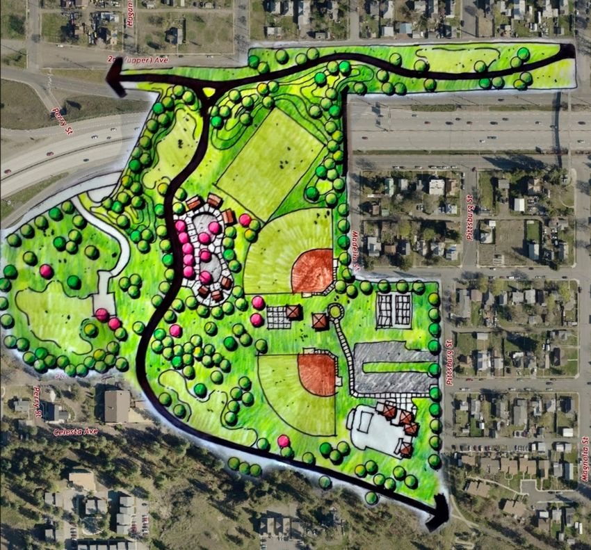
TABLE OF
    CONTENTS
               EXECUTIVE SUMMARY .......................................................6

               CHAPTER ONE: INTRODUCTION .....................................9
                   OVERVIEW ................................................................................................... 9
                   EVERY PLACE COUNTS ..................................................................... 11

               CHAPTER TWO: SPOKANE ............................................. 15
                   ISSUES AND GOALS ............................................................................. 15
                   EXISTING CONDITIONS ................................................................... 17
                   DISCUSSION ............................................................................................. 18
                   DESIGN AND POLICY STRATEGIES ............................................. 20
                   LESSONS LEARNED ............................................................................... 24
                   NEXT STEPS .............................................................................................. 26

               CHAPTER THREE: NASHVILLE ........................................ 31
                   ISSUES AND GOALS ............................................................................. 31
                   EXISTING CONDITIONS ................................................................... 33
                   DISCUSSION ............................................................................................. 34
                   DESIGN AND POLICY STRATEGIES ............................................. 36
                   LESSONS LEARNED ............................................................................... 47
                   NEXT STEPS .............................................................................................. 48

               CHAPTER FOUR: PHILADELPHIA ................................... 49
                   ISSUES AND GOALS ............................................................................. 49
                   EXISTING CONDITIONS ................................................................... 51
                   DISCUSSION ............................................................................................. 54
                   DESIGN AND POLICY STRATEGIES ............................................. 55
                   LESSONS LEARNED ............................................................................... 60
                   NEXT STEPS .............................................................................................. 61

               CHAPTER FIVE: MINNEAPOLIS-ST.PAUL ...................... 63
                   ISSUES AND GOALS ............................................................................. 63
                   EXISTING CONDITIONS ................................................................... 65
                   DISCUSSION ............................................................................................. 66
                   DESIGN AND POLICY STRATEGIES ............................................. 67
                   LESSONS LEARNED ............................................................................... 71
                   NEXT STEPS .............................................................................................. 73

4                                   U.S. DOT | Every Place Counts Design Challenge Summary Report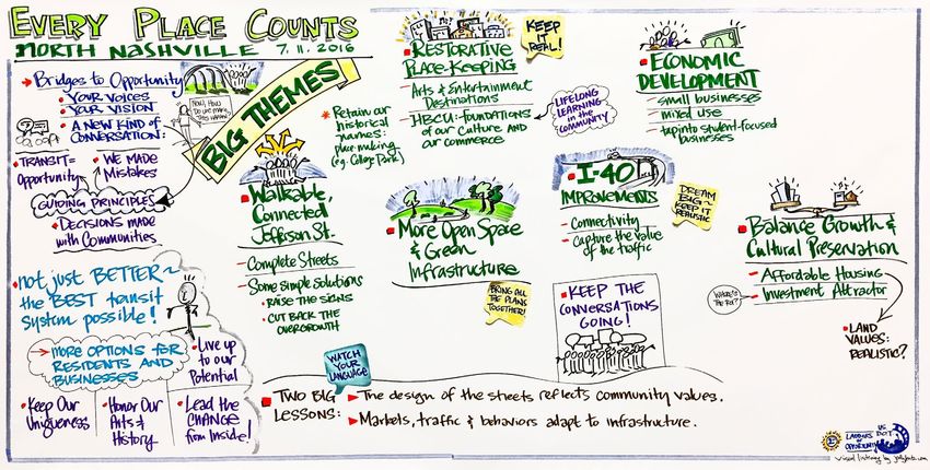
CHAPTER SIX: BEST PRACTICES ..................................... 75
      CASE STUDY #1:
         ALTERNATIVES PROJECT STUDY (I-375) ........................ 75
      CASE STUDY #2:
         SOUTH BRONX/SHERIDAN EXPRESSWAY (I-895) ...... 77
      CASE STUDY #3:
         LIVABLE CLAIBORNE COMMUNITIES (I-10)................. 78
      CASE STUDY #4:
         AUBREY DAVIS PARK/TRAIL, AND BRIDGES (1-90) ... 79
      CASE STUDY #5:
         THE CAP AT UNION STATION (I-670) ............................ 81
      ADDITIONAL RESOURCES............................................................... 82
      GLOSSARY ................................................................................................. 84

U.S. DOT | Every Place Counts Design Challenge Summary Report                                                         5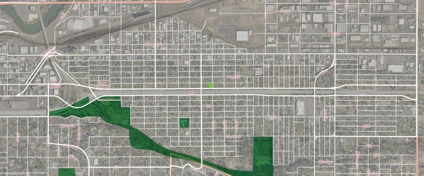
EXECUTIVE
    SUMMARY
                          As transportation infrastructure across the country reaches the end of its design
                          lifespan, public officials face a historic opportunity to invest in infrastructure
                          that can provide communities with increased opportunity, connectivity, health,
                          and quality of life. Transportation Secretary Anthony Foxx has committed to
                          this vision of building Ladders of Opportunity, reconnecting neighborhoods,
                          revitalizing communities, and empowering residents to have a meaningful voice
                          in the transportation decisions that affect their lives. The U.S. Department of
                          Transportation’s (U.S. DOT) Every Place Counts Design Challenge is helping to
                          make this vision a reality.

                          Backed by the Federal Highway Administration (FHWA) Every Day Counts program,
                          Every Place Counts leveraged federal, state, and local resources for practices that
                          enhance mobility and access while building opportunity and equity for local
                          neighborhoods.

                          In July 2016, U.S. DOT hosted Every Place Counts Design Challenge visioning
                          workshops in four cities to engage directly with neighborhoods adjacent to
                          planned or existing transportation infrastructure projects. These workshops
                          convened federal advisors, state agencies, local officials, community organizations,
                          and neighborhood residents to explore design and policy approaches to creating
                          connected, economically prosperous, and environmentally and physically healthy
                          communities:

                              t   In Spokane, WA, participants focused on the partially-built US
                                   395 and the aging I-90, examining strategies to build connectivity,
                                   restore opportunity, and mitigate impacts of the planned US
                                   395/I-90 interchange.
                              t   In Nashville, TN, community leaders from historically African-
                                   American North Nashville discussed reversing the decline of
                                   neighborhoods along Jefferson Street where I-40 divides the
                                   city.

    Spokane, Washington

6                                         U.S. DOT | Every Place Counts Design Challenge Summary Report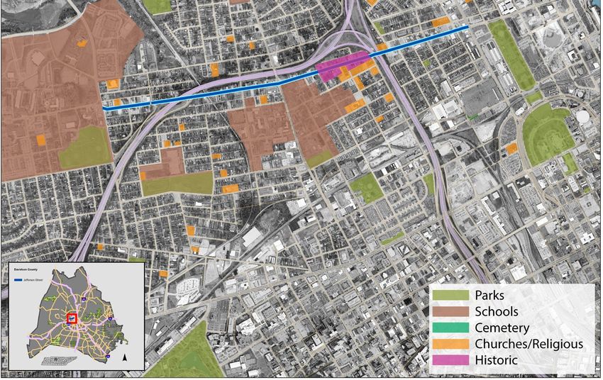
t   In Philadelphia, PA, city and regional agencies, community
          leaders, and residents collaborated on strategies to mitigate
          I-676’s impact on the surrounding neighborhoods, specifically
          Chinatown, and important civic institutions.
     t   In Minneapolis/St. Paul, MN, residents and local officials led
          a conversation about the historic impact of I-94 on minority
          communities—and how to reverse those effects.

This report summarizes the conversations, concerns, and solutions that emerged
during these four workshops. Among other things, the Every Place Counts
Design Challenge confirms that, when we acknowledge the negative impacts and
consequences of past decisions, and engage and listen to neighborhoods, it is
possible to restore opportunity and hope in bisected communities.

Nashville, Tennessee

Philadelphia, Pennsylvania

U.S. DOT | Every Place Counts Design Challenge Summary Report                    7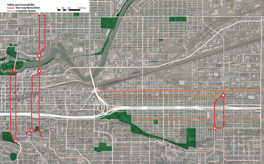
U.S. DOT found that the following general strategies are applicable to any
                          community undertaking a similar project:

                              t   Engage stakeholders early and continuously to gather feedback
                                   and gain support for implementation.
                              t   Use follow-up workshops to refine proposals and seek feedback.
                              t   Commission technical studies to support transportation and
                                   green space recommendations.
                              t   Pursue pilot projects, including road diets, lane reconfigurations,
                                   street conversions, bike lanes, and tactical approaches to test the
                                   feasibility of long-term capital investments.
                              t   Investigate funding opportunities for construction and
                                   maintenance of long-term capital projects and features.
                              t   Seek solutions that implement placemaking and economic
                                   development strategies while protecting affordability, equity,
                                   and character.

                          From better public engagement strategies to cutting-edge designs for highway
                          caps, the design and policy approaches that emerged in Spokane, Nashville,
                          Philadelphia, and Minneapolis/Saint Paul will resonate across America as more cities
                          apply innovations to address the legacy of their highway infrastructure.

    St. Paul, Minnesota

8                                         U.S. DOT | Every Place Counts Design Challenge Summary Report
ONE: OVERVIEW
INTRODUCTION
Drawing on the results of the Every Place Counts Design Challenge, this report
contains strategies for setting a constructive tone, engaging the affected public,
building buy-in from decision-makers, and envisioning realistic solutions to improve
health, mobility, access, and prosperity.
Throughout the visioning workshops, a number of broad themes and common
values emerged across the four cities. Leaders and residents alike wanted:
t Connectivity within and between neighborhoods.
t Expanded green space and trails.
t Improved safety for all road users including drivers, cyclists, and
pedestrians.
t Greater access for multi-modal transportation.
t Increased prosperity without displacement, a higher quality of
life, and preservation of community character and cohesion.
Additionally, participants identified a number of common challenges for
reconnecting neighborhoods, chiefly: funding, political will, and the lack of local
consensus. They also acknowledged that communities have been damaged and
sought to engage a full spectrum of affected stakeholders. When these challenges
were addressed through leadership, facilitation, and outreach, consensus and
community buy-in proved far easier to build.
Each community presented unique opportunities for building connectivity. All four,
however, showed particular promise in the authentic identity of their communities,
the commitment and engagement of local leaders, the powerful sense of purpose
displayed by residents, and the wealth of possible strategies and solutions
generated by everyday citizens.
Many of these assets exist in every urban community, no matter how blighted or
disconnected. Projects that build on these themes, address these challenges,
and harness these opportunities can reverse the effects of infrastructure blight,
while those that ignore them face significant challenges. Now is a crucial moment
for cities—a time to engage honestly with communities and to connect with their
residents who are ready and willing to work for change.
Interstate 40 in Nashville, TN
U.S. DOT | Every Place Counts Design Challenge Summary Report 9Specific next steps for each city are detailed in the following chapters; the U.S.
Department of Transportation (U.S. DOT) design team found that communities
undertaking similar projects should:
t Engage stakeholders early and often to gather useful feedback
and gain support for implementation.
t Organize follow-up workshops to refine proposals and seek
feedback.
t Commission technical studies to analyze the feasibility of
transportation and green space recommendations and chart a
path to implementation.
t Pursue pilot projects, including road diets, lane reconfigurations,
street conversions, bike lanes, and tactical approaches to test the
feasibility of long-term capital investments.
t Investigate funding opportunities for construction and
maintenance of long-term capital projects and features.
t Maximize the placemaking and economic development potential
of all investments, while protecting affordability, equity, and
character.
From better public engagement strategies to cutting-edge designs for highway
caps, the design and policy approaches that emerged in Spokane, Nashville,
Philadelphia, and Minneapolis/Saint Paul will resonate across America as more cities
struggle with the legacy of their highway infrastructure.
Participants in Nashville were asked for “One Word” to describe the current conditions
10 U.S. DOT | Every Place Counts Design Challenge Summary ReportEVERY PLACE COUNTS Since the Federal-Aid Highway Act of 1956, America has spent billions of dollars creating a world-class national transportation system. For decades, that system has been integral to our national economy—supporting the growth of businesses, connecting people and places, and shaping our regions, cities, towns, and rural landscapes. Infrastructure choices made by the U.S. Department of Transportation (U.S. DOT) and elsewhere at the Federal, State, and local levels have strengthened communities and improved the quality of life for residents. However, that same highway network transportation system often reinforced dividing lines within communities and created physical barriers to opportunity. As major infrastructure was built through existing communities, residents were separated from social and economic centers, key resources and services, and the nearby destinations of their daily lives. Today, much of that burdensome infrastructure is reaching the end of its initial life—and these communities face a watershed moment. Cities and states are facing the need to invest billions of dollars in transportation projects, which have the opportunity to become catalysts for revitalizing and reconnecting bifurcated neighborhoods. These connections have the potential to spur better health and economic outcomes. U.S. DOT seeks to help local and tribal governments across the country ensure that current and future transportation projects connect and strengthen communities. Transportation Secretary Anthony Foxx has made reconnecting neighborhoods a priority for improving community health and opportunity, especially in historically low-income and minority neighborhoods. Through Every Place Counts, U.S. DOT is working to create infrastructure investment outcomes that reflect a more inclusive America, reconnect people to opportunity, and reinvigorate community engagement by empowering decision- makers to develop context-sensitive, stakeholder-driven solutions. STATEMENT OF PURPOSE On May 4, 2016, the U.S DOT launched the Every Place Counts Design Challenge, offering provided technical assistance to local governments through two-day “community vision” design sessions to improve access to reliable, safe, and affordable transportation in disconnected communities. The purpose of the challenge was to raise awareness about bifurcated neighborhoods, identify innovative practices to reconnect communities, and inform the transportation planning and project life cycle. To qualify, applicants were required to: 1) assemble a “community team” of U.S. DOT | Every Place Counts Design Challenge Summary Report 11
elected officials, transportation professionals, and a cross-section of community
     residents; 2) provide a descriptive narrative of a transportation infrastructure
     challenge that limits access to social or economic centers and other essential
     services; 3) explain their goals; and 4) submit Letters of Support from their State
     Departments of Transportation and/or other entities, such as community groups,
     transit agencies, port authorities, MPOs ,and other political subdivisions of State or
     local governments.

         Date                    Action
         May 18, 2016            Informational Webinar
         May 20, 2016            Applicant Registration Deadline
         June 3, 2016            Applicant Submission Deadline

     On June 27, 2016, U.S. DOT selected four recipients from a number of highly
     competitive applications for this technical assistance award. Each recipient received
     a two-day design charrette, hosted by local governments in their community.
     The sessions gave recipients the opportunity to receive technical assistance
     on transportation and conceptual design from experts in the field. The design
     sessions were meant to inform, prepare, and enable recipients to better engage in
     federal transportation planning, programming, the National Environmental Policy
     Act process, and funding programs. The U.S. DOT led these design sessions with
     representatives from regional and national design, architecture, engineering, and
     planning firms to participate as technical experts in these design sessions.

     GOALS
     The Every Place Counts Design Challenge seeks to raise awareness, spark innovation,
     and encourage inclusive design solutions that bridge the infrastructure divide and
     reconnect people to opportunity.

     Challenge Goals
         t  Encourage communities to reimagine existing transportation
             projects via innovative and restorative infrastructure design
             practices that correct past mistakes, reconnect people and
             neighborhoods to opportunity, and reinvigorate opportunity
             within communities.
         t  Empower communities and decision-makers to develop context-
             sensitive design solutions that incorporate the input of the
             people and communities they touch.

     Selected Projects

12                    U.S. DOT | Every Place Counts Design Challenge Summary Report
U.S. DOT selected the following four communities to receive a Community
Vision Design Session, ensuring a diverse representation of projects and
communities:
t Spokane, WA (West) | July 7-8
t Nashville, TN (South) | July 11-12
t Philadelphia, PA (North) | July 14-15
t Minneapolis/St. Paul, MN (Mid-America) | July 18-19
TYPICAL WORKSHOP SCHEDULE
Each workshop was designed to familiarize the national experts with the local
context, engage with community stakeholders, build consensus around local project
goals, and develop and share possible strategies to reach those goals.
DAY 1
Time Theme Activity
8:00 AM Set up Studio/Workshop Room
Kick-Off Meeting
- Introductions
9:00 AM
- History & Background
- Broad Overview of Next Two Days
10:00 AM
Site Visit & Tour
11:00 AM
12:00 PM Lunch Meeting & Discussion
1:00 PM
Group Table Exercises
- Community Presentation
Discovery
2:00 PM - Overview & Visioning Process
- Community Vision Development
3:00 PM - Community Vision Assessment
Design
Summarization of Input
4:00 PM
- Design Team Initiates Starter Ideas
5:00 PM Prepare for Public Presentation
Public Presentation
- Introduction by City Leader
6:00 PM -
- Presentation by Design Team Representative
8:00 PM
- Question & Answer
- Group Exercise
U.S. DOT | Every Place Counts Design Challenge Summary Report 13DAY 2
Time Theme Activity
8:00 AM Recap of Day 1
9:00 AM
Theme Refinement
- Design Team Continues Work on Products
- Stakeholders Continue to Refine Themes
10:00 AM
11:00 AM
Design
12:00 PM Lunch Meeting & Discussion
1:00 PM
Finish Products & Prepare For Final Presentation
Documentation
2:00 PM
3:00 PM Final Public Presentation
- Recap Design Challenge
3:00 PM - - Presentation of "Big Ideas"
5:30 PM - Q&A & Comments from Public
HOW TO UNDERSTAND THIS DOCUMENT
The following four chapters are dedicated to the work completed in each of the
selected communities. The designs shown in the following examples represent
some of the illustrative ideas that helped make the Every Place Counts Design
Challenge visioning workshops so productive. However, the images shown
are only conceptual and are likely to evolve through continued community
engagement before implementation.
Each location will need to prioritize the recommendations below relative to their
overall local transportation needs. The results of the Every Place Counts Design
Challenge should be seen as a framework for identifying community needs and
desires to launch a more in-depth process.
14 U.S. DOT | Every Place Counts Design Challenge Summary ReportTWO: ISSUES AND GOALS
SPOKANE,
WASHINGTON The City of Spokane, WA applied for the Every Place Counts Design Challenge
to bring together transportation officials, community leaders, design experts,
and local stakeholders to discuss strategies for reconnecting the East Central
Neighborhood across Interstate 90, as well as at the unbuilt connection of
US 395 and I-90. The City’s goal was to host a productive exchange between
decision-makers and residents to generate solutions that would maximize
connectivity while minimizing the impact of I-90 and US 395 on the community.
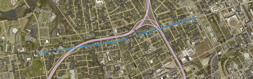
Spokane’s main highway, I-90, runs east-to-west through downtown Spokane and
adjacent neighborhoods. When it was built more than 50 years ago, I-90 bisected
the working-class East Central Neighborhood and removed hundreds of homes.
The highway still poses a significant barrier to connectivity between residential
areas to its south and the mix of civic and religious institutions, employers, and
educational facilities to the north.
Meanwhile, the currently under construction US 395 / North Spokane Corridor has
undergone many planning and design iterations since its original 1997 proposal. As
a part of this project, the design and footprint of the highway’s connection to I-90
have been scaled back, leaving vacant a swath of land that had been acquired for
the larger roadway along I-90. As final designs are not complete, the City has raised
questions: How should the new highway connect to the existing I-90 in East Central
Neighborhood? Can it be done in a way that connects, rather than further bisects,
the community?
U.S. DOT | Every Place Counts Design Challenge Summary Report 15With the assistance of the design team, officials and stakeholders gathered for
two days to brainstorm creative and practical solutions to improve connectivity
between I-90, the partially unbuilt US 395, and the interchange between the two
in the East Central Neighborhood. In addition to creating a comprehensive design
strategy for greater connectivity, stakeholders sought assistance with the following:
Vacant Land Redevelopment
The reduction of the I-90 footprint in the I-90 modernization project
(a part of the US 395 / North Spokane Corridor project), has left areas
of vacant land where affordable neighborhoods once stood. Ideas were
sought for how to use these vacant half-blocks, which run 1.5 miles along
the length of the corridor, and to help neighborhood leaders and residents
envision a positive future.
Bike/Pedestrian Facilities
An important feature of the US 395 project is a new trail, called the
Children of the Sun Trail, which will run alongside US 395 when complete.
Spokane has an extensive trail system and the city would like to improve its
connectivity, quality, and usage. The Every Place Counts Design Challenge
provided an opportunity to think comprehensively about how the
forthcoming Children of the Sun Trail might connect to the existing trail
system—particularly within the East Central Neighborhood.
Safe, Attractive Overpasses
Neighborhood residents wanted to provide input on the three
replacement pedestrian overpasses that are planned to cross I-90, and
how they could be designed to provide safe and attractive passage for
pedestrians and cyclists in strategic locations.
Improved Transit Connections
Spokane is currently developing a high-performance transit system for
the Sprague Avenue Corridor in the East Central Neighborhood. The
Every Place Counts Design Challenge provides an opportunity to study
how best to connect residents south of I-90 with the proposed enhanced
transit services.
16 U.S. DOT | Every Place Counts Design Challenge Summary ReportEXISTING CONDITIONS In the late 1950s, I-90 was constructed through the heart of Spokane, bisecting the historic working-class neighborhood of East Central Spokane and siphoning energy from East Sprague Avenue, which runs parallel to the highway. Today, another limited access highway is making its way through Spokane’s historic neighborhoods. The US 395 / North Spokane Corridor project, located just east of downtown, is a four- to six-lane highway that will connect to I-90 once complete. Over $750 million in funding for the completion of the new US 395 / North Spokane Corridor was dedicated in 2015. This funding will be used between 2016 and 2029 to construct the remaining southern half of the freeway, construct the Children of the Sun Trail, and connect them to I-90 and the City’s existing trail system. Based on the Washington State DOT’s (WSDOT) latest official traffic volumes, a small traffic study was conducted during the visioning workshop. Each day, I-90 carries approximately 128,800 vehicles through downtown Spokane. The two highways that feed I-90 from the east have a combined daily total of 19,700, which is approximately 15% of the daily volume in the downtown. Conservatively, half of the 15% originated from or was destined to Spokane. Consequently, no more that 7.5% of the traffic on I-90 in downtown Spokane (less than 9,700 vehicles per day) is through traffic, which means that 92.5% or more of the traffic on I-90 is comprised of local trips that begin and end within the city. That imbalance indicates that I-90 is overbuilt for the 9,700 cross-state vehicles that travel through Spokane and the primary function of I-90, currently in Spokane, is local trip-making and local access. These numbers provide the residents with a number of opportunities to better manage traffic flow and reconnect neighborhoods. For example, the East Sprague corridor community is in the process of designing a new streetscape for East Sprague Avenue and has already began upgrading public lighting (street, underpass, and alleyway) in and around the City’s E. Sprague Targeted Investment Area. U.S. DOT | Every Place Counts Design Challenge Summary Report 17
DISCUSSION

     Over the course of two days, the design team led an extensive public engagement
     process with key stakeholders and members of the community to reimagine the
     I-90 corridor through the East Central Neighborhood, envision reconnecting
     neighborhoods on both sides of the highway, and discuss the impacts of the
     incoming US 395 / North Spokane Corridor. Stakeholders were encouraged to
     think broadly and boldly while identifying opportunities to implement new ideas.

     STAKEHOLDER INPUT
     Stakeholder conversations covered diverse topics such as complete streets, green
     infrastructure, and programming in underutilized open spaces as ways to enhance
     the East Central Neighborhood and mitigate the worst impacts of the current
     highway. Additionally, some groups discussed redesigning I-90 and the unbuilt
     portion of US 395 as urban boulevards. As a part of the final presentation, the
     Every Place Counts design team also proposed “out of the box” ideas such as
     converting one-way streets to two-way streets and employing urban roundabouts
     in downtown Spokane as a means to create greater connectivity across the wider
     street network.

     Through the workshop, stakeholder groups refined topic areas into themes to serve
     as the focus of the two days. Stakeholder input was refined through an iterative
     process, and by the middle of day two, a vision for the corridor—and the City of
     Spokane—began to emerge.

         Draft Vision Statement
         Residents and business owners stay in Spokane and have the strongest voice in
         determining design outcomes and receive the receptive ear of local and state
         decision makers.

18                   U.S. DOT | Every Place Counts Design Challenge Summary Report
Value Statements
t Ensure public investment is used to strategically encourage private
investment.
t Land uses should be supported by planning, infrastructure, financial
incentives, and long-term assistance.
t Promote strategic redevelopment of private vacant land and public
right-of-way.
t Private redevelopment and infill need to reflect and serve the diverse
community.
t Public infrastructure should reflect the values of the community
including the impacted neighborhood.
Groups discussed each recommendation to determine the impact-to-effort ratio
of each. As the conversation progressed, a number of key benefits and challenges
emerged (e.g. partners, potential political barriers, etc.).
One of the major themes that emerged from these conversations was the desire
to not create the same challenges again. All agreed that I-90, when built, created a
barrier, and that US 395 has the potential to create yet another barrier. By engaging
and discussing its impact early on, residents felt more confident than ever that
the US 395 project could improve, rather than impair, connectivity for residents
and businesses of the East Central Neighborhood, as well as those in northern
neighborhoods most impacted by the US 395 development.
Neighborhood streets disconnected by I-90
U.S. DOT | Every Place Counts Design Challenge Summary Report 19DESIGN AND POLICY STRATEGIES
Spokane began the Every Place Counts Design Challenge process hoping to
generate strategies for improving connectivity and mitigating neighborhood
impacts in the East Central Neighborhood north and south across Interstate 90 and
the connection of the partially unbuilt US 395. Several possible design strategies
for achieving those goals were developed.
CONNECTIVITY AND RECONNECTIONS/CROSSING I-90
Improve current and future pedestrian under- and overpasses
Additional connectivity strategies for I-90 included wider, more comfortable
pedestrian overpasses at frequent intervals, making ramps gradual to accommodate
bicycles, pedestrians, and scooters, improving lighting at underpasses, and adding
wayfinding signage to indicate throughways or provide directions to key locations.
In Boston, the Massachusetts Department of Transportation (MassDOT) partnered
with a local design studio to put a creative, ornamental light display under Interstate
93 connecting East Berkeley Street to West 4th Street in the South Boston. Since
MassDOT began making pedestrian improvements, the underpass has hosted
an urban innovation festival and now houses shipping containers hydroponically
growing fresh vegetables for a local restaurant chain. Other North American cities
such as Toronto, San Antonio, and San Jose have similarly improved the pedestrian
experience beneath underpasses with the creative use of lighting and art, as well as
programming activities in these spaces.
A light installation under I-93 strengthening pedestrian connections
20 U.S. DOT | Every Place Counts Design Challenge Summary ReportDesign areas underneath and adjacent to the highway with active community involvement to incorporate neighborhood culture, art, and history If the US 395 design continues as an elevated limited access highway, possible uses for areas beneath it include parks/parklets, a farmer’s market, art installations, stormwater management, and community gardens. Examples of highway underpasses activated with light displays, art installations, and cultural activities Investigate a partial lid or cap over depressed areas of the highway to increase north/south connectivity (multi-use for commercial/residential options) One way to achieve greater connectivity would be to construct a lid or cap over I-90 at Liberty Park, reclaiming open space lost during the construction of I-90. A cap over the highway adjacent to Liberty Park could serve many constituencies by creating a safe, attractive, and comfortable crossing for pedestrians, bikes, and disabled users. While only an idea, a lid could also enhance connectivity for car travel by reconnecting one or more streets that are currently disconnected by I-90. Locally, this idea was met with concerns about financial feasibility. Additional investigation of a partial lid or cap would be needed to examine the technical and financial feasibility of a project of this scale within Spokane. . U.S. DOT | Every Place Counts Design Challenge Summary Report 21
NORTH SPOKANE CORRIDOR
Begin detail design and construction of the Children of the Sun Trail now
One possible good faith gesture to build community buy-in is to build the
associated Children of the Sun Trail before the highway. Building the trail, which
is planned for at-grade construction and would also be highly compatible with
a surface-boulevard US 395, is unlikely to represent a significant early outlay or
significantly interfere with highway construction.
Program underutilized open spaces with a year-round community activity
calendar
Activating spaces under highways is a challenge, but initiating events that gather
people below it may get the public used to the idea of US 395 as a welcoming
public space.
OPEN SPACE AND GREEN INFRASTRUCTURE
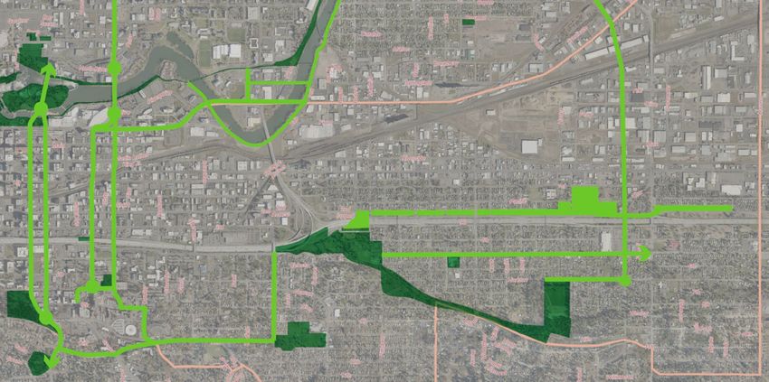
Connect a network of parks and trails to form an open space system and a
recreation loop
Spokane has an extensive system of trails and more are planned. This network
could be seamlessly linked to the city’s open space and parks system, both current
and forthcoming, to form a recreation loop throughout the city.
Open space network connecting parks for recreation
22 U.S. DOT | Every Place Counts Design Challenge Summary ReportThe Children of the Sun Trail, planned adjacent to US 395, could be the north- south connector on the eastern edge of the connected recreation loop. Future trail systems planned just north of I-90 near 2nd Avenue could connect to the Children of the Sun Trail to the east and Liberty Park in the center. Incorporate enhanced programming for all ages and include educational, historic, and cultural civic art features throughout the neighborhood Programming should celebrate the community’s heritage and diversity. Moreover, the green spaces afforded by the lid could be made usable with ball fields and playgrounds to serve as a destination for both sides of the highway and a nexus for the city’s extensive trail system. Layer the functions of air and water quality, wildlife corridors, and tree canopy coverage through streets and open spaces Urban trees, green roofs, and vegetation can help manage stormwater, reduce the urban heat island effect, deflect solar radiation, release moisture into the atmosphere, and provide recreation amenities. The incorporation of green infrastructure, such as bioswales, rain gardens, and filtration beds, can help the City manage stormwater runoff and adapt to changing climate conditions. SAFETY AND ACCESSIBILITY Improve the comfort and safety along existing accessible routes for all mobility options throughout the neighborhood For example, include more and shorter crosswalks, increased lighting, and other security measures. Give all citizens access to multi-modal transportation and information To improve routing and rideshare possibilities, integrate public transit agencies into neighborhood planning and design strategies. It is important to note that this is only part of the overall mobility answer, but it is an important one and is not currently part of the conversation. As the City continues to explore High Performance Transit routes, these concerns will become increasingly salient. U.S. DOT | Every Place Counts Design Challenge Summary Report 23
LESSONS LEARNED

     As the first of four visioning workshops, Spokane set the tone for the Every Place
     Counts Design Challenge. The primary lessons learned in Spokane concerned
     engagement, planning, and responsiveness—and held great value for the other
     three Design Challenge cities, as well as for other communities undertaking public
     engagement campaigns around major infrastructure projects.

     Honor What Was Said In the Room
     While I-90 through Spokane poses a significant barrier to connectivity, the majority
     of stakeholders chose to focus on the incoming US 395 North Spokane Corridor
     and how its design might hinder or improve connectivity in the East Central
     neighborhood and those impacted neighborhoods to the north.

     Furthermore, though big ideas for the future of I-90 were discussed and presented,
     stakeholders had expressed reservations about the feasibility of some of these
     ideas by the end of day two. These discussions were articulated through a series
     of exercises that informed the development of the project vision statement and
     guiding themes.

     While physically located within the same room, the design team worked
     independently from these exercises to prepare visualizations of possible design
     solutions and assemble the final presentation. Hearing about ideas that were no
     longer a priority in the final presentation made some stakeholders feel that they
     were not heard. The concurrent tracks did not inform one another to the degree
     required to align the work of both groups.

     Finding opportunities for feedback loops at regular intervals throughout the
     workshop would better integrate the outcomes of workshop exercises with the
     work of the design team. Furthermore, a project liaison, charged with tracking both
     groups, could help ensure that outcomes of discussions with the public inform the
     work of the design team. Before presenting final visuals and recommendations
     to the public at the workshop conclusion, the liaison should review to ensure the
     public feedback was heard and incorporated.

24                    U.S. DOT | Every Place Counts Design Challenge Summary Report
Don’t Settle for (Or Accept) Old Plans and Approaches Well before the start of the Every Place Counts Design Challenge, WSDOT and the City of Spokane proved that they were not willing to settle for old plans and old modes of thinking. They had already re-evaluated the original plans and reduced the footprint of the US 395 North Spokane Corridor. And because five miles of the freeway have yet to be finished and plans for how the freeway connects to I-90 are still under development, stakeholders were willing to envision further changes. If not for the Every Place Counts Design Challenge, the idea of evolving the unbuilt five miles of US 395 into a context-sensitive urban boulevard might never have been proposed. While stakeholder consensus did not coalesce around this concept—as conditions were not right to have a fully in-depth conversation—a public conversation can continue that might ultimately influence the final design of US 395 and the future of I-90 in a positive way. U.S. DOT | Every Place Counts Design Challenge Summary Report 25
NEXT STEPS

     The Every Place Counts Design Challenge visioning workshops were only two days
     long and were intended to start the discussion on reconnecting neighborhoods.
     The items listed below are neither comprehensive nor listed by priority, but rather
     are provided to further the conversation. Spokane could consider these strategies
     to achieve improved neighborhood connectivity along I-90 and the connection of
     US 395 in the East Central Neighborhood:

     NEAR-TERM
         r   &TUBCMJTI B QBSUOFSTIJQ CFUXFFO 4QPLBOF 1MBOOJOH  &DPOPNJD
              Development, Public Works, and Transportation Departments), and
              WSDOT to explore:
              o   Maintaining state designation for US 395;
              o   Improving connectivity across I-90 with new bridges, lid parks, and
                  highway caps;
              o   Possibly reimagining the final leg of US 395 as a multi-lane surface
                  boulevard or other alternative to the raised, limited access US 395
                  plan.
         t   Organize a follow-up workshop, jointly sponsored by the City and
              WSDOT, to investigate alternatives to the raised, limited-access US 395
              plan.
         t   Host regular meetings to update community stakeholders and gather
              feedback.
         t   Form a multi-agency alliance including state, city, and, county officials to
              act as the decision-making body for North Spokane Corridor decisions.
         t   Consider a tactical installation in the underutilized space beneath I-90 to
              demonstrate progress and spur local buy-in, coinciding with a citywide
              cycling event, farmer’s market, or craft fair.
         t   Pilot a temporary road diet and street conversion using paint, planters,
              and temporary construction, possibly during off-peak hours or along
              limited street sections.
         t   Engage public transit agencies to improve routing, explore rideshare
              options, and contribute to street conversion plans and streetscape
              designs.
         t   Investigate funding opportunities for construction and maintenance
              of new capital projects and features, including Fixing America’s Surface
              Transportation (FAST), AARP Livable Communities, local Safe Routes to
              School program, and the Trust for Public Land.

26                   U.S. DOT | Every Place Counts Design Challenge Summary Report
MID-TERM
t Improve streetscape elements (tree-planting and lighting), bike lanes, and
on-street parking throughout downtown Spokane to enhance connectivity
across the wider street network.
t Install new permanent lighting, art, and signage along crossings over and
under I-90.
t Update zoning codes to require pedestrian-friendly new buildings and
additions through form-based codes or land-use guidelines.
t Break ground on the Children of the Sun Trail and link to the existing
Spokane trail network.
LONG-TERM
In addition to the recommendations above, a number of suggestions presented to
Design Challenge participants came directly from the design team’s expertise and
their review of the study area, though not directly from stakeholder conversations.
These included suggestions for improved connectivity on a wider scale than the
immediate project scope of the Every Place Design Challenge. Spokane could
consider one or all of the following recommendations in the long-term. If the
City, with their partners, decides to pursue the ideas below, it is important to
convene stakeholder groups and build off the Design Challenge results, as many
of these projects require multi-year planning processes and major infrastructure
investments:
t One-way to two-way street conversion.
t Constructing the final leg of US 395 as a multi-lane surface boulevard or
other feasible alternative to limited access facility.
t A lid or cap connecting Liberty Park across I-90.
One-way to two-way street conversion
In addition to featuring severed connections due to the construction of I-90,
Spokane’s street grid suffers from reduced connectivity downtown because of a
large number of one-way streets. If key high-capacity roads are restored to two-
way traffic, the number of north-south connections across I-90 would increase
significantly.
Moreover, the Every Place Counts design team suggested that employing
roundabouts at key intersections would allow traffic to move uninterrupted along
U.S. DOT | Every Place Counts Design Challenge Summary Report 27Two-way conversion streets
corridors while still providing choice of direction. Experts suggested that fewer
stops at major intersections could please motorists while safer speeds and crossing
distances would improve walkability.
Proposed two-way and complete street conversions included:
1. Stevens Street and Washington Street
2. Brown Street and Division Street
3. Division Street and Ruby Street (north of river)
4. Thor Street and Freya Street
Investigate redesign of the unbuilt portion of US 395 as an at-grade multiway
boulevard
Instead of a limited access freeway, US 395 /North Spokane Corridor could be built
as a context-sensitive urban surface street. Many cities across the country have
embraced the use of multiway boulevards for handling high-capacity urban traffic
while creating an active, comfortable, and connected public realm.
Investigate a partial lid or cap over depressed areas of the highway to increase
north/south connectivity (multi-use for commercial/residential options)
As mentioned, one way to achieve greater connectivity would be to construct a
lid over I-90 at Liberty Park, reclaiming open space and providing a number of
additional safe, attractive, and comfortable crossings for pedestrians, bikes, and
disabled users over I-90.
At-grade multiway boulevard concept
28 U.S. DOT | Every Place Counts Design Challenge Summary ReportThe Every Place Counts design team explored one lid concept as a demonstration exercise. A tree-lined green lid would actively connect the natural Ben Burr trail south of the highway to the larger Centennial trails in the north. Linking those greenways would ensure greater connectivity and safety, as trail users would not be required to cross moving traffic near the highway, and contribute to neighborhood health and quality of life. Liberty Park cap concept In exploring a lid over I-90, Spokane and WSDOT must balance adding green space and improving street connectivity. Streets across an I-90 lid would connect north and south. The best candidate streets for reconnection are Perry, Helena, and Madelia, though feasibility would be based on topography, cost, final design, and other factors to connect each street. Finally, a highway cap is a creative way to meet multiple community goals as well as reclaim a portion of public space once thought lost to history—Liberty Park. If a lid moves forward and the final design of I-90’s connection to US 395 does not use the currently vacant land adjacent to I-90, this land, which runs parallel to 2nd Avenue, could be used as another trail or greenway that ultimately connects to the highway lid. U.S. DOT | Every Place Counts Design Challenge Summary Report 29
30 U.S. DOT | Every Place Counts Design Challenge Summary Report
THREE:                                    ISSUES AND GOALS
NASHVILLE,
TENNESSEE                                 The Metropolitan Government of Nashville and Davidson County (Metro)
                                          applied for the Every Place Counts Design Challenge to explore reconnecting
                                          and revitalizing the neighborhoods surrounding I-40 near Jefferson Street.
                                          The City’s goal was to build consensus among decision-making officials and
                                          neighborhood leaders, open lines of communications, and generate design
                                          strategies for mitigating the impact of transportation infrastructure.

                                          In the 1960s, the construction of I-40 displaced 1,400 North Nashvillians, mostly
                                          African-Americans, and bisected several historically significant business districts
                                          and neighborhoods like Elizabeth Park, Fisk, and Meharry. The construction of
                                          I-40 significantly impacted the Jefferson Street corridor, which runs parallel to I-40
                                          for several blocks. Jefferson Street connects those historic neighborhoods and
                                          serves as a center for the African American community in Nashville. Three of the
                                          city’s historically black colleges and universities—Fisk University, Tennessee State
                                          University, and Meharry Medical College—are all located along or near Jefferson
                                          Street, as are many of the oldest black church congregations in the city.

                                          The plan for the Every Place Counts Design Challenge’s two-day visioning
                                          workshop in Nashville was to engage with community residents, business owners,
                                          and neighborhood institutions through well-established community partnership
                                          networks in order to generate design strategies and explore implementation funds
                                          to improve neighborhood connectivity. The community looked to Every Place
                                          Counts for help with the following:

U.S. DOT | Every Place Counts Design Challenge Report | Nashville, TN                                                              31
Improve Connectivity along Jefferson Street
Metro Planning and the local community both recognize the need to
improve connectivity to Jefferson Street. The city’s 2015 NashvilleNext
General Plan identifies significant walking and biking projects—originally
components of the Gateway to Heritage Walking Improvements project.
Plan for Aging Infrastructure
While Jefferson Street and D.B. Todd Boulevard bridges are not yet
structurally deficient, they continue to age. The community sees their
replacement as an opportunity to reconnect bifurcated neighborhoods
and expand access to social and economic resources.
Connect to Past Work and Ongoing Efforts
The Gateway to Heritage Project improved the area near the 28th Avenue
and Jefferson Street interchange. Further improvements that build upon
this initial work might include partial capping and bike/pedestrian
overpasses or underpasses.
Explore a Partial Cap of the Highway
A large-scale intervention like a partial cap—explored in the Nashville
Civic Design Center’s Shaping the Healthy Community—could create
new developable land, improve parking, and support affordable housing
for parcels rendered undevelopable by the highway. A smaller-scale
intervention may also have profound impacts, such as a “quick-build”
project for immediate improvements to conditions on the existing bridge
deck.
Strategic interventions where the most immediate impact is possible
32 U.S. DOT | Every Place Counts Design Challenge | Nashville, TNEXISTING CONDITIONS Despite decades of disinvestment, Jefferson Street features strong educational institutions, a tight-knit community, and a well-organized business alliance: the Jefferson Street United Merchants Partnership (JUMP). Through the Gateway to Heritage project, the community has secured funding to enhance Jefferson Street, the Interstate overpasses, and the 28th Avenue interchange. The project, which includes a public plaza, honors the area’s history and has successfully improved the overpass and interchange at 28th Avenue. The Jefferson Street bridge over I-40, built in 1967, carries approximately 14,000 vehicles per day. In 2013 it was rated in good condition, but narrow, cracked sidewalks and wide travel lanes create an unsafe environment for pedestrians and cyclists. The D.B. Todd Boulevard Bridge, which carries 10,000 vehicles per day and was also built in 1967, is considered functionally obsolete. Currently, Nashville is experiencing a boom in both private development and public investment, even in neighborhoods that have historically seen limited activity. At the same time, the City has invested in multi-modal improvements such as bike lanes, pedestrian facilities, and streetscapes in several neighborhoods. The Every Place Counts Design Challenge aimed to leverage those investments to improve the quality of life for current residents in North Nashville. U.S. DOT | Every Place Counts Design Challenge Report | Nashville, TN 33
DISCUSSION

                                                      The Every Place Counts Design Challenge workshop focused on improving
                                                      connectivity along the Jefferson Street corridor, restoring Jefferson Street as the
                                                      cultural center of North Nashville, and empowering the community to guide future
                                                      change along Jefferson Street. As the conversation progressed over the two-day
                                                      workshop, many stakeholders agreed:
                                                            t   Jefferson Street should remain the main corridor that connects North
                                                                 Nashville’s minority neighborhoods,
                                                            t   The ongoing and successful “Gateway to Heritage” project could be
                                                                 expanded, and
                                                            t   The two I-40 overpasses at Jefferson Street and Dr. D.B. Todd
                                                                 Boulevard could be replaced with alternatives that improve pedestrian
                                                                 access and increase neighborhood connectivity.
                                                      In order to organize these community-generated ideas, the design team took a
                                                      strategic intervention approach—pinpointing areas along Jefferson Street and
                                                      I-40 where transportation or design interventions would have the most immediate
                                                      impact.

     Activity node areas where existing activity could be leveraged for new activities, development, and strategic interventions.

34                                                                           U.S. DOT | Every Place Counts Design Challenge | Nashville, TN
STAKEHOLDER INPUT
Over two days, the design team led a public engagement process with stakeholders
and residents to reimagine the Jefferson Street Corridor and North Nashville’s
relationship to I-40. Participants considered options for new bridges and possible
highways caps, as well as design and policy strategies for revitalizing Jefferson
Street. Stakeholders widely expressed a desire to see that new development and
infrastructure reflects the history of the community. Housing affordability, health,
art, entertainment, and cultural heritage also received significant discussion.
Together, the participants crafted a vision for North Nashville and identified four
themes to be explored by the Every Place Counts Design Challenge team.
Draft Vision Statement
A vibrant revitalized neighborhood with diverse housing options that
welcomes new infill development while protecting current residents,
supports local businesses and institutions while encouraging new
investment, and celebrates local history and culture while harnessing new
energy and opportunities in North Nashville.
U.S. DOT | Every Place Counts Design Challenge Report | Nashville, TN 35DESIGN AND POLICY STRATEGIES
The Every Place Counts Design Challenge visioning workshop engaged
neighborhood leaders and residents to envision a connected, revitalized Jefferson
Street/I-40 corridor. The policy and design recommendations developed reflect
these discussions and are informed by best practices from around the country.
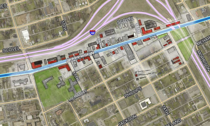
INTERSTATE 40 (I-40)
t Explore an Interstate cap or lid to provide public green space and connectivity.
t Examine existing conditions for pedestrians, cyclists, and drivers as well as the
quality of the street environment for residences and businesses.
Jefferson Street to Jackson Cap
A cap over I-65 could better connect the west and east sides of North Nashville
with Jefferson Street serving as the anchor. The “Jefferson to Jackson” Cap concept
shows how a cap over I-65 could be lined with shallow mixed-use buildings, built on
the cap itself, to create a continuous street wall of buildings along Jefferson Street
and effectively screen the highway behind. This concept has proven successful in
other North American cities, most notably in Columbus, Ohio across I-670.
Possible Jefferson Street to Jackson cap
36 U.S. DOT | Every Place Counts Design Challenge | Nashville, TNA wide highway cap could also reconnect streets such as Phillips Street, Meharry
Boulevard, and Jackson Street, significantly increasing connectivity across I-40. In
this scenario, the physical and visual barrier of the depressed highway would be
replaced by an active green space that serves as a gateway honoring the arts and
cultural heritage of the community. Moreover, timing is important: eventually, the
Jefferson Street overpass will need to be replaced. A cap could be considered as
one alternative for replacement.
Existing Jefferson Street bridge over I-40
Possible Jefferson Street cap with mixed-use buildings
16th Street Cap
Much like the Jefferson to Jackson Cap concept, a highway cap spanning I-40
between 16th Street and Dr. D.B. Todd Boulevard would effectively re-stitch the
neighborhoods north and south of I-40 and act as a gateway for Fisk University.
Neither 16th Street nor 17th Street connects north and south because of the
presence of I-40. With a cap, one or both of these streets could connect once again,
partially repairing the street network.
Because of the existing historic and culturally significant businesses in this portion of
the corridor, the cap could be utilized for open space and active park use. The east
end of the cap could run from 16th Street to the south to 17th Street to the north to
reconnect the historic street grid.
As with the Jefferson Street overpass, the Dr. D.B. Todd overpass will eventually
need to be replaced. A cap could be considered as one alternative for replacement.
U.S. DOT | Every Place Counts Design Challenge Report | Nashville, TN 37Alameda Street wide greenway
28th Street Gateway
The 28th Street Gateway concept attempts to improve north-south connectivity in
two important ways. Residents were concerned about the narrow space afforded
to sidewalks, the difficulties crossing the street, the unpleasant look of the highway,
and the high traffic.
First, at 28th Street where I-40 is elevated, the adjacent streets and on-ramps would
be retrofitted with roundabouts to improve vehicle circulation, reduce speeds, and
improve pedestrian safety. This idea, suggested by the Every Place Counts Design
Challenge team, is new to the Nashville area but was warmly accepted by the
community members involved in the discussions. Further discussion and feasibility
testing will be essential.
Second, the existing pedestrian bridge over Alameda Street would be enhanced
with a wide, elevated greenway—connecting existing walking and biking trails across
I-40. This wider, greener pedestrian connection would likely increase mobility and
walkability. This bridge could serve as a gateway feature over to the park space and
provide easy access for pedestrians and bicycles to cross the highway.
38 U.S. DOT | Every Place Counts Design Challenge | Nashville, TNYou can also read