ESTIMATION OF LAND SURFACE ALBEDO FROM GCOM-C/SGLI SURFACE REFLECTANCE
←
→
Page content transcription
If your browser does not render page correctly, please read the page content below
ISPRS Annals of the Photogrammetry, Remote Sensing and Spatial Information Sciences, Volume V-3-2021
 XXIV ISPRS Congress (2021 edition)

 ESTIMATION OF LAND SURFACE ALBEDO FROM GCOM-C/SGLI SURFACE
 REFLECTANCE

 J. Susaki a, *, H. Sato b, A. Kuriki a, K. Kajiwara c, Y. Honda c
 a Graduate School of Engineering, Kyoto University, C1-2-332, Kyotodaigakukatsura, Nishikyo-ku, Kyoto 615-8540, Japan;
 {susaki.junichi.3r, kuriki.amane.3w}@kyoto-u.ac.jp
 b Graduate School of Advanced Integrated Studies in Human Survivability, Kyoto University, 1 Nakaadachi-cho, Yoshida,

 Sakyo-ku, Kyoto 606-8306, Japan; solidsnake.hs16@gmail.com
 c Center for Environmental Remote Sensing, Chiba University, 1-33, Yayoicho, Inage-ku, Chiba-shi,

 Chiba, 263-8522 Japan; kkaji@faculty.chiba-u.jp, yhonda@mtf.biglobe.ne.jp

 Commission III, WG III/10

KEY WORDS: Land surface albedo, GCOM-C/SGLI, BRDF model, Multi-regression model

ABSTRACT:

This paper examines algorithms for estimating terrestrial albedo from the products of the Global Change Observation Mission –
Climate (GCOM-C) / Second-generation Global Imager (SGLI), which was launched in December 2017 by the Japan Aerospace
Exploration Agency. We selected two algorithms: one based on a bidirectional reflectance distribution function (BRDF) model and
one based on multi-regression models. The former determines kernel-driven BRDF model parameters from multiple sets of reflectance
and estimates the land surface albedo from those parameters. The latter estimates the land surface albedo from a single set of reflectance
with multi-regression models. The multi-regression models are derived for an arbitrary geometry from datasets of simulated albedo
and multi-angular reflectance. In experiments using in situ multi-temporal data for barren land, deciduous broadleaf forests, and paddy
fields, the albedos estimated by the BRDF-based and multi-regression-based algorithms achieve reasonable root-mean-square errors.
However, the latter algorithm requires information about the land cover of the pixel of interest, and the variance of its estimated albedo
is sensitive to the observation geometry. We therefore conclude that the BRDF-based algorithm is more robust and can be applied to
SGLI operational albedo products for various applications, including climate-change research.

 1. INTRODUCTION The MODIS albedo products are generated by using the
 bidirectional reflectance distribution function (BRDF)-driven
The Japan Aerospace Exploration Agency (JAXA) initiated the method (Strahler et al., 1999). Kernel-driven BRDF models are
Global Change Observation Mission (GCOM) to observe data on regarded as robust and semi-empirical and can be applied to any
a global scale for analyzing global climate change and water type of land cover (Lucht et al., 2000). The kernel is a function
circulation mechanisms. Under this project, GCOM – Climate determined by the viewing and illumination geometries. BRDF-
(GCOM-C) was launched successfully in December 2017, and driven albedo estimation requires a certain number of
the Second-generation Global Imager (SGLI) onboard GCOM-C observations. For example, MODIS operational BRDF/albedo
is expected to measure reflectance and radiation in the region of products use at least seven good-quality reflectance data points
visible to infrared wavelengths (GCOM-C, 2021a). In December obtained within 16 days. However, this requirement is
1999, the Moderate Resolution Imaging Spectroradiometer challenging for tropical and subtropical climate regions where
(MODIS) sensor was launched, and it is still in operation. SGLI optical images suffer from cloud contamination. Simulation
and MODIS have equivalent spatial resolutions, (i.e., 250 m and analysis has shown that the more observations that are
1 km), but SGLI has more bands than MODIS, including three contaminated by noise, the more unstable the estimated BRDF
polarimetric bands for a better understanding of atmospheric model parameters (Susaki et al., 2004). Consequently, in such
properties. regions there is often little or no data available for MODIS
 BRDF/albedo products; however, the available products have an
SGLI is designed to provide operational products regarding land, acceptable accuracy (Susaki et al., 2007). Therefore, to obtain
atmosphere, ocean, and cryosphere. Terrestrial albedo is one of stable albedo products, a technique is required for estimating
the most important physical parameters for understanding the albedo from fewer observations. Such an approach would
global circulation of water and heat, and climate-change research increase the temporal resolution of albedo products.
requires long-term and global datasets of albedo. Albedo is
defined as the ratio of upwelling and downwelling irradiances, Cui et al. (2009) presented a method that utilizes an empirical
where irradiance is derived from the integral of radiance over a relation between bidirectional reflectance and albedo by using
given hemisphere. Using the SGLI data, we aim to develop an Polarization and Directionality of the Earth’s Reflectances
algorithm for operational terrestrial albedo products. Therefore, (POLDER) data. It provides a direct estimate of land-surface
in this paper we examine an algorithm for the stable estimation broadband albedo from a single bidirectional observation.
of daily SGLI-based albedo from surface reflectance. Similar approaches using multi-regression models were adopted
 in (Liang et al., 2013). Qu et al. (2014) also extended this method
 for estimating broadband albedo from MODIS data and multi-
 angular POLDER-3 data. They generated regression models with
* Corresponding author the MODIS reflectance as the dependent variable and the multi-

 This contribution has been peer-reviewed. The double-blind peer-review was conducted on the basis of the full paper.
 https://doi.org/10.5194/isprs-annals-V-3-2021-227-2021 | © Author(s) 2021. CC BY 4.0 License. 227
ISPRS Annals of the Photogrammetry, Remote Sensing and Spatial Information Sciences, Volume V-3-2021
 XXIV ISPRS Congress (2021 edition)

channels of the POLDER-3 reflectance as the independent (IGBP). The original IGBP land-cover map contains 17 classes,
variables. They implemented landcover classification by using and the monthly and yearly databases of the 16 classes other than
reflectance in the blue channel and the normalized difference water bodies are available. The monthly databases contain the
vegetation index (NDVI), and pixels of interest were classified best-quality BRDFs for each month independently, whereas the
into three landcovers, i.e. vegetation, non-vegetation, and yearly databases contain the high-quality pixels from a full year
snow/ice. The multi-regression models for each landcover class with the aim of monitoring the annual cycle of surface reflectance
estimate the broadband albedo from MODIS reflectance data and the directional signature. The central wavelengths of the
observed in a single measurement. The algorithm estimates daily publicly available channels are 490, 565, 670, 765, 865, and 1020
albedo with improved temporal resolution. However, that nm (Lacaze et al., 2009).
technique requires landcover classification for pixels of interest
in order to select optimal multi-regression models, and such 2.3 Field Data
classification may hamper accurate albedo estimation. This is
because (i) the classification may include errors and (ii) We measured the broadband albedo and bidirectional reflectance
landcover for multi-regression models is quite ambiguous (i.e., factor (BRF) data at two sites in Japan, namely the Tottori Sand
vegetation and non-vegetation), and thus the multi-regression Dune, which is classified as barren land, and the Yamashiro Test
models do not represent the landcover of interest. Compared to Field (Ataka et al., 2014), which is classified as deciduous
this multi-regression-based method, the aforementioned BRDF- broadleaf forest. The site details are presented in Table 2.
based method has an advantage that no landcover information is
required. Therefore, in this paper we examine two methods—one We measured the BRF data at wavelengths of 300–2500 nm by
based on a BRDF model and one based on multi-regression using a portable spectroradiometer (Field Spec 3, Analytical
models—for the stable estimation of SGLI-based albedo from Spectral Devices, USA) under clear-sky conditions (ASD, 2021).
surface reflectance. The measurements were conducted at a height of 1.5 m for barren
 land and of 28.5 m for the deciduous broadleaf forest. In the
 2. DATA USED AND STUDY AREA measurement of BRF data, we set the relative azimuth angles of
 the solar and viewing directions to 15°, 45°, 90°, 135°, and 180°
2.1 SGLI Data to save on measurement time. We chose 15° instead of 0° to avoid
 contamination from the equipment shadow. The viewing angle
Table 1 gives the specifications of the SGLI bands. SGLI was was set to 0°, 15°, 30°, and 45°. We used a 5° field-of-view lens
designed to measure ocean color, land cover, vegetation, snow, in the measurement. We also measured the broadband albedo for
ice, clouds, and aerosols (Shimoda, 2018). The visible and near- wavelengths of 285–3000 nm by using a four-component net
infrared non-polarization channels are observed using a push- radiometer (MR-60; EKO Instruments, Japan) (EKO, 2021). The
broom scanner, while shortwave and thermal infrared are instrument mounts two hemisphere pyranometers, one on the
measured using an optical mechanical scanner. Herein, “channels” upper flat side and the other on the lower flat side.
and “bands” refer to the same concept.

 Wavelength Wavelength (a) Tottori (barren land)
Channel IFOV Channel IFOV
 [nm] [nm] Area Latitude, longitude
 VN1 375–385 VN9 757–769 Tottori Sand 35°32'42.0"N, 134°14'03.0"E
 VN2 407–412 VN10 858.5–878.5 250 m Dune, Tottori 35°32'44.8"N, 134°14'02.0"E
 VN3 438–448 VN11 858.5–878.5 Pref., Japan 35°32'43.4"N, 134°14'04.1"E
 VN4 485–495 SW1 1040–1060
 250 m 1 km (b) Yamashiro (deciduous broadleaf forest)
 VN5 520–540 SW2 1370–1390
 VN6 555–575 SW3 1530–1730 250 m Area Latitude, longitude
 VN7 663.5–683.5 SW4 2185–2235 1 km Yamashiro Test Field, Forest
 34°47'25.0"N,
 Research and Management
 VN8 663.5–683.5 135°50'27.3"E
 Organization, Kyoto Pref., Japan
Table 1. Specifications of Second-generation Global Imager
(SGLI) channels (GCOMa, 2021). Table 2. Names and geolocations of study areas.

2.2 POLDER-3 Data
 3. METHODS
POLDER-3 was developed by the Centre National D'études
Spatiales (CNES) in France and placed on board the Polarization Flowcharts of the two methods chosen for estimating albedo from
& Anisotropy of Reflectances for Atmospheric Sciences coupled land surface reflectance are shown in Figure 1, namely, the
with Observations from a Lidar (PARASOL) micro-satellite that BRDF-based method [Figure 1(a)] and the multi-regression-
was launched in December 2004; its function was terminated in based method [Figure 1(b)]. Before explaining the two methods,
December 2013. POLDER-3 was a push-broom scanner that we explain the primary modules used therein.
provided samples of the BRDF of every point on Earth for
viewing angles of up to 60°–70° at a spatial resolution of 3.1 Kernels
approximately 6 km (Lacaze et al., 2009).
 A kernel used for estimating the BRDF and terrestrial albedo is a
The publicly available BRDF data follow the land-cover types function of the bidirectional reflectance determined by the
proposed by the International Geosphere-Biosphere Programme viewing and illumination geometries (Pinty et al., 1991; Wanner

 This contribution has been peer-reviewed. The double-blind peer-review was conducted on the basis of the full paper.
 https://doi.org/10.5194/isprs-annals-V-3-2021-227-2021 | © Author(s) 2021. CC BY 4.0 License. 228
ISPRS Annals of the Photogrammetry, Remote Sensing and Spatial Information Sciences, Volume V-3-2021 XXIV ISPRS Congress (2021 edition) and Strahler, 1995; Hao et al., 2020). In general, we consider two types of scattering observed from an object on the terrestrial Multiple-sets of SGLI surface, namely volumetric scattering and geometric scattering. surface reflectance For the volumetric-scattering kernel, Ross (1981) developed a kernel for the directional reflectance above a horizontally homogeneous plant canopy. Roujean et al. (1992) derived the Kernel-driven BRDF Ross-Thick kernel, which was designed for use in areas with model parameters large values of leaf area index and does not consider hotspot effects. The geometric-scattering kernel calculates the scattering from sunlit and shaded objects and backgrounds; for example, Surface narrowband albedos tree crowns are approximated as spheroids to calculate their surface scattering. The semi-empirical kernel-driven BRDF NTB conversion model expressed by Equation (1) has been used for the operational BRDF and albedo products of MODIS (Roujean et Surface broadband albedos al., 1992; Strahler et al., 1999): (a) , , POLDER-3 BRDF DB (1) , , , , . Band conversion Here, i, v and are solar zenith angle, viewing zenith angle and SGLI multiple-sets of the relative azimuth angle, respectively. fiso, fvol, and fgeo are surface reflectance unknown coefficients. Users can select any combination of volumetric- and geometric-scattering kernels, the values of which are determined once the illumination and viewing kernel-driven BRDF Surface reflectance at geometries are given. model parameters a specific geometry Landcover The three unknown coefficients in Equation (1) are determined by minimizing the least-squares error between the observations classification Surface narrowband albedos and the estimated albedos. In operational application, MODIS Surface reflectance BRDF products are produced as follows. If at least seven cloud- NTB conversion (Veg/Non-veg/Ice) free observations of the surface are available during a 16-day period, then a full model inversion is attempted. First, the Surface broadband albedos available data are evaluated to discard any outliers, and additional checks are performed to ensure positive kernel weights. If the data pass these evaluations, then a full inversion, or a normal Multi-regression model inversion, is performed to establish the BRDF parameter weights Actual Surface reflectance (Veg/Non-veg/Ice) that provide the best root-mean-square error (RMSE) fit. Landcover classification Actual Surface reflectance 3.2 Narrowband and Broadband Albedo Estimation (Veg/Non-veg/Ice) With the estimated BRDF model parameters, we estimate the narrowband albedo, which is an albedo for a relatively narrow Surface broadband albedo wavelength range. In most cases, the wavelength range is (b) equivalent to the bands designed for satellite sensors. Before estimating the narrowband albedo, we start with the narrowband Figure 1. Methods for estimating terrestrial albedo: (a) using black-sky and white-sky albedos. The black-sky albedo is a BRDF model; (b) using multi-regression models. virtual albedo in the absence of a diffuse component, while the white-sky albedo is a virtual albedo in the absence of a direct component when the diffuse component is isotropic. The actual albedo at a given wavelength is expressed as a linear combination 3.3 Method Based on BRDF Model of the black-sky and white-sky albedos by using the atmospheric optical depth (Strahler et al., 1999). As shown in Figure 1(a), the BRDF-based method starts with multiple sets of SGLI reflectance observed during several The broadband albedo is defined for wider wavelength ranges, observations. First, the unknown coefficients used in the kernel- such as 0.3–3.0 m or 0.3–5.0 m. However, no sensor measures based BRDF models in Equation (1) are determined by the radiance over such a wide wavelength range; therefore, it is minimizing the least-squares error between the observations and impossible to estimate the broadband albedo directly from the estimated albedos. The coefficients are then used to estimate observed sensor data. Instead, the broadband albedo is estimated the surface narrowband albedos. Finally, the surface broadband by extrapolation, expressed as a linear regression model of albedos are determined by applying NTB conversion to the several narrowband albedos (Liang, 2000). This conversion is narrowband albedos. known as narrow-to-broadband (NTB) conversion. This contribution has been peer-reviewed. The double-blind peer-review was conducted on the basis of the full paper. https://doi.org/10.5194/isprs-annals-V-3-2021-227-2021 | © Author(s) 2021. CC BY 4.0 License. 229
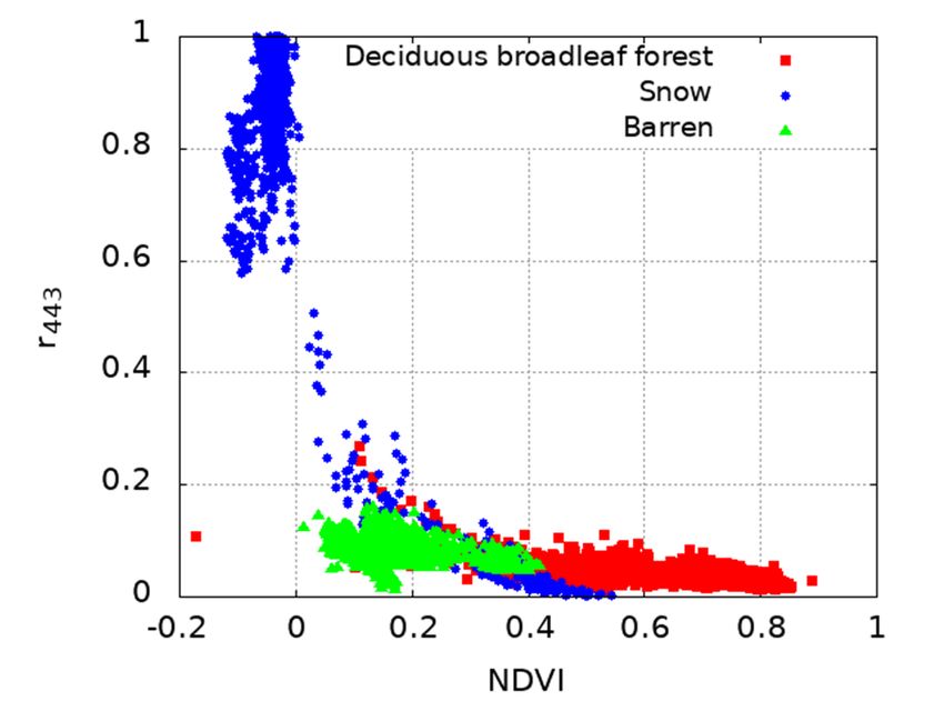
ISPRS Annals of the Photogrammetry, Remote Sensing and Spatial Information Sciences, Volume V-3-2021 XXIV ISPRS Congress (2021 edition) 3.4 Landcover Classification calculated by the same procedure except using the POLDER-3 RSR. The approach of estimating albedo via BRDF model parameters has the advantage of requiring no information about land-cover As for the in situ data measured by Field Spec 3, the reflectances type in the area of interest. In contrast, the approach of estimating of SGLI and POLDER-3 channels were calculated. With the set albedo from a set of reflectances requires a priori information of reflectances, a multi-regression model was generated that used about land-cover type because the BRDF shape depends strongly six channels of POLDER-3 reflectances as the independent on land cover; accordingly, the coefficients of the multi- variables and a specific channel of SGLI reflectance as the regression models, which are explained in the following section, dependent variable. depend on land-cover type. Therefore, selecting the optimal multi-regression models requires having the land-cover 4.2 NTB Conversion information. In operational albedo products, it may be possible to refer to the IGBP land-cover map, among others. However, using For the kernel-driven BRDF model in Equation (1), we used the such a land-cover map can cause errors due to misclassification Ross-Thick kernel for volumetric scattering and the Li-Sparse or the mixed pixel problem in maps containing more than one kernel for geometric scattering (Strahler et al., 1999). We land-cover type. Therefore, we decided to classify land cover into collected in situ BRF data and albedo data for several types of three types: vegetation, non-vegetation, and ice/snow. land cover and used them to determine the coefficients of NTB conversion. We constrained the coefficients to be non-negative Figure 2 shows a scattergram of NDVI versus reflectance at the and determined them by minimizing Akaike’s information wavelength of 443 nm, which is the center wavelength of VN3 criterion (AIC) (Akaike, 1974). For a given model, AIC assesses of SGLI. The data were generated as simulated SGLI data from its performance by evaluating both the number of variables used POLDER-3 data. Three classes of data were used for the in the model and the sum of the errors. Note that VN6 was scattergram, namely, (i) deciduous broadleaf forest (IGBP-4), (ii) excluded from the calculation because its radiance may be snow/ice (IGBP-15), and (iii) barren or sparsely vegetated saturated in land cover with high reflectance. The obtained model (IGBP-16). Figure 2 shows that the combination of NDVI and of NTB conversion is reflectance at 443 nm can be used to classify pixels into these three classes, albeit that some snow/ice points with higher NDVI 0.2233 0.4005 0.1463 , (2) and lower reflectance at 443 nm may be difficult to separate. The approach taken in this research is to classify the SGLI datasets into three land-cover classes beforehand. where is the narrowband albedo of band i. NTB conversion for SGLI 0.30 Calibration 0.25 Validation Estimated albedo 0.20 0.15 Figure 2. Scattergram of reflectance versus normalized difference vegetation index (NDVI) at the wavelength of 443 0.10 nm. 0.10 0.15 0.20 0.25 0.30 Actual albedo 4. EXPERIMENTS Figure 3. Scattergram of actual albedo versus that estimated In this research, we define the broadband albedo as that measured by narrow-to-broadband (NTB) conversion for SGLI. in the wavelength range of 0.285–3.0 m because the albedo “Calibration” denotes the calibration data used to determine meter used in the field measurements covered those wavelengths. Equation (2), and “Validation” denotes the validation data (Susaki et al., 2020). 4.1 Conversion from POLDER-3 to SGLI bands The measured digital numbers of the samples were converted into reflectances of the bands defined for SGLI by using the SGLI relative spectral response (RSR) and the digital numbers of a reference. The reflectances of the bands for POLDER-3 were also This contribution has been peer-reviewed. The double-blind peer-review was conducted on the basis of the full paper. https://doi.org/10.5194/isprs-annals-V-3-2021-227-2021 | © Author(s) 2021. CC BY 4.0 License. 230
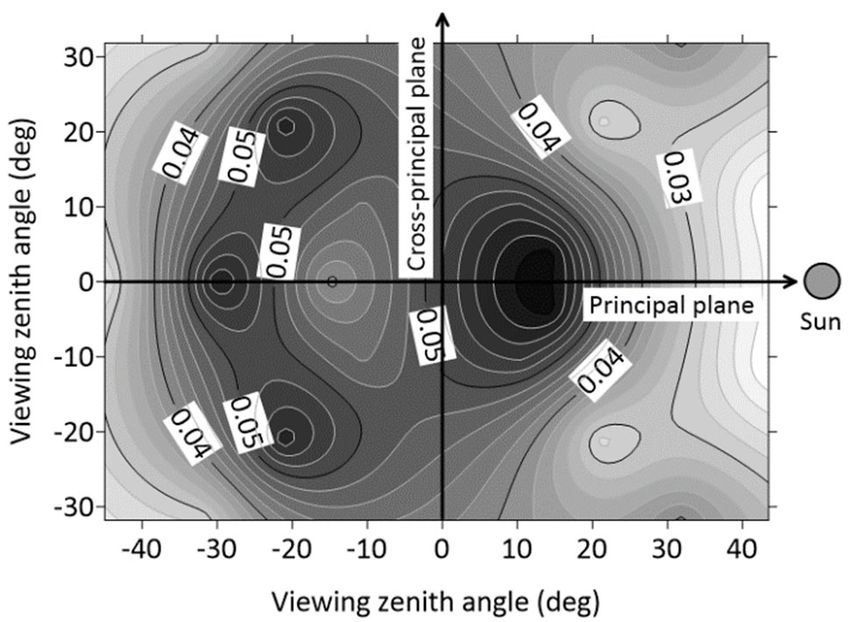
ISPRS Annals of the Photogrammetry, Remote Sensing and Spatial Information Sciences, Volume V-3-2021 XXIV ISPRS Congress (2021 edition) For calibration, we used the reflectances of barren land (11 points), deciduous broadleaf forest (three points), and paddy fields (one point), and the RMSE for the 15 points was 0.010. To validate Equation (2), we used barren land (nine points), deciduous broadleaf forest (three points), and grassland (two points); the RMSE was 0.023, which is acceptable. As reported by Susaki et al. (2020), Figure 3 shows a scattergram of actual albedo versus that estimated by NTB conversion. 4.3 Multi-regression Model Estimation for Albedo Estimation We determined the coefficients of multi-regression models for (a) the dataset including surface reflectance and albedo for a specific geometry. We set the interval for the solar and sensor zenith angles as 5° and that for the relative azimuth angle as 15°. The latter is larger because the relative azimuth angle is less sensitive to the coefficients compared with the two zenith angles. We generated multi-regression models of three types: vegetation, non-vegetation, and snow/ice. From the scattergram in Figure 2, we set the following class thresholds to determine the models: vegetation: NDVI ≥ 0.5 and 443 ≤ 0.2; non-vegetation: 0 ≤ NDVI < 0.4 and 443 ≤ 0.2; (12) snow/ice: NDVI ≤ 0 and 443 ≥ 0.6. (b) 4.4 Accuracy Assessment Figure 4. Contour maps of root-mean-square error (RMSE) of First, we assessed the multi-regression models by using in situ multi-regression model for IGBP LC16, barren or sparsely data measured in barren land and deciduous broadleaf forest. We vegetated. The RMSE was calculated by using the residual examined the possible combinations of SGLI bands as between the simulated and estimated albedo. The solar zenith independent variables of the regression model and found VN5, angle was set to 0° and 30° for (a) and (b), respectively. VN8, VN11, and SW1 to be the best combination in terms of AIC. The RMSE was calculated by using the residual between the simulated and estimated albedo. Table 3 gives the RMSE for each geometry, and Figure 4 shows a contour map of the RMSE of the estimated albedo when compared with the actual in situ albedo. 5. DISCUSSION Figure 4 was generated by applying the kriging technique to the results of Table 3. The final RMSEs for all geometries are 0.020 5.1 Multi-regression Model Estimation for Albedo for barren land and 0.044 for deciduous broadleaf forest. Note Estimation that some results for specific geometries are excluded from Table 3(b) because strong reflectances were observed that may have In this research, we examined a method for estimating albedo been due to scattering by the tower. from a single set of surface reflectances by using multi-regression models. The models were generated from multi-angular We then examined the validity of both the BRDF-based and simulated SGLI surface reflectance. To improve the accuracy of multi-regression-based methods for estimating surface albedo by the albedo estimation, we examined the performance of multi- applying SGLI data. Because the spatial resolution of SW3 (i.e., regression models having a number of independent variables 250 m) is finer than that of the other shortwave bands (i.e., 1 km), among the following 10 channels: VN1, VN2, VN3, VN5, VN6, we again examined the possible combinations of SGLI bands as VN8, VN11, SW1, SW3, and SW4. We found that the models independent variables of the regression model under the with more independent variables do not always generate better condition that SW3 is included in the independent variables. We accuracy. For example, the validation results show that some found VN8, VN11, and SW3 to be the best combination in terms models with six or seven independent variables have an RMSE of AIC. Table 4 gives the RMSEs of the temporal albedo of approximately 0.06 for barren land, which is much worse than estimated by the two different approaches. One approach is to use that in Table 3. Also, cases were observed in which the absolute multi-regression models generated from the data of vegetated values of the coefficients were far too sensitive to changes in the areas. The other approach is to use the BRDF model parameters sensor zenith angle, as were the signs of the coefficients (i.e., provided in SGLI atmospheric-corrected land surface reflectance positive or negative). These observations may be the result of (RSRF) products (GCOM-C, 2021b). The BRDF model POLDER-3 data having relatively low spatial resolution, parameters are generated as a by-product of RSRF, and the (approximately 6 km); the model estimation uses the albedo processing uses the kernels reported by Maignan et al., (2004). simulated based on POLDER-3 data. Note that we did not include the assessment results for Tottori because valid SGLI data were available only for October 28, 2019. This contribution has been peer-reviewed. The double-blind peer-review was conducted on the basis of the full paper. https://doi.org/10.5194/isprs-annals-V-3-2021-227-2021 | © Author(s) 2021. CC BY 4.0 License. 231
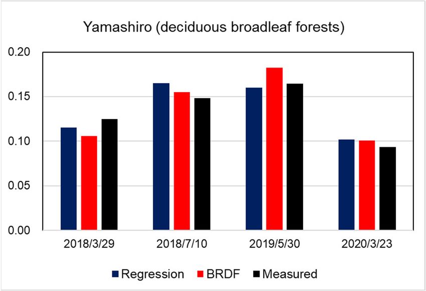
ISPRS Annals of the Photogrammetry, Remote Sensing and Spatial Information Sciences, Volume V-3-2021
 XXIV ISPRS Congress (2021 edition)

 (a)
 vz (deg) az (deg) RMSE # of samples
 15 15 0.026 36
 15 45 0.019 37
 15 90 0.021 38
 15 135 0.022 37
 15 180 0.026 37
 30 15 0.018 37
 30 45 0.016 37
 30 90 0.016 37
 30 135 0.025 38
 30 180 0.023 37
 45 15 0.014 37
 45 45 0.014 37
 45 90 0.016 39
 45 135 0.018 37
 (a) 45 180 0.020 39
 Total 0.020 560

 (b)
 vz (deg) az (deg) RMSE # of samples
 15 15 0.058 8
 15 45 0.055 8
 15 135 0.046 8
 15 180 0.040 8
 30 15 0.037 8
 30 45 0.031 8
 30 135 0.058 8
 30 180 0.060 8
 45 15 0.020 8
 45 45 0.042 8
 45 135 0.030 8
 (b) 45 180 0.025 8
 Total 0.044 96
Figure 5. Contour map of RMSE of estimated albedo. (a) Barren
or sparsely vegetated (IGBP LC16). (b) Deciduous broadleaf
forest (IGBP LC4). Table 3. Root-mean-square error of estimated albedo. (a)
 Barren or sparsely vegetated (IGBP LC16). (b) Deciduous
 broadleaf forest (IGBP LC4). “vz” and “az” are sensor zenith
 angle and relative azimuth angle, respectively.

 Area Landcover Regression BRDF
 Yamashiro Deciduous 0.011 0.014
 broadleaf forests

 Table 4. Root-mean-square errors of estimated temporal
 albedo for Yamashiro, Japan, shown in Figure 6. “Regression”
 denotes the results applying multi-regression models for
 vegetation class to SGLI surface reflectance, and “BRDF”
 denotes the results using the BRDF model parameters
Figure 6. Temporal albedo of Yamashiro, Japan estimated from provided in SGLI surface reflectance products.
SGLI data. “Regression” denotes the results applying multi-
regression models for vegetation class to SGLI surface
reflectance, and “BRDF” denotes the results using the BRDF
model parameters provided in SGLI surface reflectance
products.

 This contribution has been peer-reviewed. The double-blind peer-review was conducted on the basis of the full paper.
 https://doi.org/10.5194/isprs-annals-V-3-2021-227-2021 | © Author(s) 2021. CC BY 4.0 License. 232
ISPRS Annals of the Photogrammetry, Remote Sensing and Spatial Information Sciences, Volume V-3-2021
 XXIV ISPRS Congress (2021 edition)

The POLDER-3 data measured in 2008 were aggregated monthly, ASD, ASD FieldSpec range, https://www. malvernpanalytical.
and it is possible to derive monthly-based multi-regression com/en/products/product-range/asd-range/fieldspec-range/index.
models. We examined the performance of such monthly-based html (accessed on Jan 4th, 2021).
models and found the estimated albedos to be less accurate. In
reality, it can be reasonable to apply monthly-based multi- Asia Flux a, http://www.asiaflux.net/ (accessed on Jan 4th, 2021).
regression models because some vegetation (e.g., deciduous
forests) has seasonally changing BRDF. However, when we Asia Flux b, Takayama deciduous broadleaf forest site, http://
derived monthly models, fewer samples were used than those asiaflux.net/index.php?page_id=112 (accessed on Jan 4th, 2021).
used to derive yearly multi-regression models, thereby leading to
unstable model estimation. Table 4 shows that the yearly multi- Asia Flux c, Mase paddy flux site, http://asiaflux.net/ index.php?
regression models generate acceptable albedo accuracy; page_id=83 (accessed on Jan 4th, 2021).
therefore, it is reasonable to use yearly multi-regression models
to generate operational albedo products. Ataka, M., Kominami, Y., Yoshimura, K., Miyama, T., Jomura,
 M. and Tani, M., 2014. In situ CO2 Efflux from leaf litter layer
5.2 Sensitivity Analysis showed large temporal variation induced by rapid wetting and
 drying cycle, Pros One, 9(10): e108404.
Next, we discuss the sensitivity of the multi-regression models.
The dark areas in Figure 4(a) and (b) represent the geometry for Cui, Y., Mitomi, Y., and Takamura, T., 2009. An empirical
which worse RMSE was generated for barren land. We set the anisotropy correction model for estimating land surface albedo
solar zenith angle to 0° and 30° for Figure 4(a) and (b), for radiation budget studies. Remote Sens. Environ., 113(1), 24-
respectively. The dark areas correspond to the hot spot of the 39.
measurement. This feature is also common to that of deciduous
broadleaf forests and indicates that the simulated SGLI surface EKO, MR-60 Net radiometer, https://eko-eu.com/products/
reflectance near the hot-spot geometry may have larger variance environmental-science/net-radiometers/mr-60-net-radiometer
than the reflectance for other geometries. (accessed on Jan 4th, 2021).

This interpretation is supported by Figure 5(a) and (b), which GCOM-C a, EORC About SGLI, https://suzaku.eorc.jaxa.jp/
show that the errors of the estimated albedo obtained using the in GCOM_C/instruments/structure.html (accessed on Jan 4th,
situ data of those solar zenith angles were not identical. However, 2021).
because most of the measurements were conducted between 9:00
and 11:00 in the morning, similar solar zenith angles were GCOM-C b, EORC, JAXA, Standard Product & Algorithm,
observed. There are dark areas around the viewing zenith angle ATBD of Atmospheric corrected reflectance [RSRF],
of approximately 15° in the principal plane in Figure 5(a) and https://suzaku.eorc.jaxa.jp/GCOM_C/data/files/SGLI_Atmcorr_
around that of approximately 10° in the principal plane in Figure ATBD_v10.pdf (accessed on Jan 4th, 2021).
5(b). Consequently, it should be noted that the albedo near a hot-
spot geometry estimated by the multi-regression models may be Hao, D., Wen, J., Xiao, Q., You, D. and Tang, Y., 2020. An
less accurate than those near other geometries. Improved Topography-Coupled Kernel-Driven Model for Land
 Surface Anisotropic Reflectance. IEEE Trans. Geosci. Remote
 6. CONCLUSIONS Sens. 58(4), 2833-2847.

In this paper, we examined two algorithms for generating Lacaze, R., Fédèle, E., & Bréon, F. M., 2009. POLDER-
GCOM-C/SGLI surface albedo products, namely, one based on 3/PARASOL BRDF databases user manual. CEA/LSCE, CNES,
a BRDF model using several sets of reflectance and one based on Paris, France, Tech. Rep, 1. http://web.gps.caltech.edu/~vijay/
multi-regression models using a single set of reflectances. pdf/POLDER-3_BRDF_User Manual-I1.10.pdf (accessed on Jan
Regarding the latter algorithm, we simulated the multi-angular 4th, 2021).
SGLI surface reflectance from the POLDER-3 surface
reflectance, and we generated datasets of simulated albedo and Liang, S., 2000. Narrowband to broadband conversions of land
multi-angular reflectance via a kernel-driven BRDF model. We surface albedo I – Algorithms, Remote Sens. Environ., 76, 213-
derived multi-regression models at an arbitrary geometry of solar 238.
zenith, sensor zenith, and relative azimuth angles for three land-
cover classes, namely, vegetation, non-vegetation, and snow/ice. Liang, S., Zhao, X., Liu, S., Yuan, W., Cheng, X., Xiao, Z. and
The experimental results show that the former algorithm Qu, Y., 2013. A long-term Global LAnd Surface Satellite
generates an albedo with an acceptable RMSE of 4.7×10⁻², (GLASS) data-set for environmental studies. Int. J. Digital Earth,
whereas the albedos estimated by the multi-regression-based 6(sup1), 5-33.
algorithm have an acceptable RMSE of 3.9×10⁻². The latter
algorithm requires landcover classification and, more Lucht, W., Shaaf, C.B. and Strahler, A.H., 2000. An algorithm
importantly, may be affected by larger variance when the surface for the retrieval of albedo from space using semiempirical BRDF
reflectance near a hot-spot geometry is used. Therefore, we models, IEEE Trans. Geosci. Remote Sens., 38, 977-998.
conclude that the BRDF-based algorithm can be applied to SGLI
operational albedo products. Maignan, F., Breon, F.-M., and Lacaze, R., 2004. Bidirectional
 reflectance of Earth targets: Evaluation of analytical models
 using a large set of spaceborne measurements with emphasis on
 REFERENCES the Hot Spot, Remote Sens. Environ., 90, 210–220.
Akaike, H., 1974. A new look at the statistical model Pinty, B. and Verstraete, M.M., 1991. Extracting information on
identification, IEEE Trans. Automatic Control, 19, 716–723. surface properties from bidirectional reflectance measurements,
 J. Geophys. Res, 96, 2,865-2,879.

 This contribution has been peer-reviewed. The double-blind peer-review was conducted on the basis of the full paper.
 https://doi.org/10.5194/isprs-annals-V-3-2021-227-2021 | © Author(s) 2021. CC BY 4.0 License. 233
ISPRS Annals of the Photogrammetry, Remote Sensing and Spatial Information Sciences, Volume V-3-2021
 XXIV ISPRS Congress (2021 edition)

Qu, Y., Liu, Q., Liang, S., Wang, L., Liu, N., and Liu, S., 2014.
Direct-estimation algorithm for mapping daily land-surface
broadband albedo from MODIS Data. IEEE Trans. Geosci.
Remote Sens., 52(2), 907-919.

Ross, J. K., 1981. The Radiation Regime and Architecture of
Plant Stands, W. Junk, Ed. Norwell, MA: Artech House.

Roujean, J.L., Leroy, M. and Deschamps, P.Y., 1992. A
bidirectional reflectance model of the Earth's surface for the
correction of remote sensing data, J. Geophys. Res., 97, 20,455-
20,468.

Shimoda, H., 2018. Gcom Science Overview and the Initial
Results of GCOM-C, Proceedings of 2018 IEEE Int. Geosci.
Remote Sens. Symposium, 6647-6650.

Strahler, A.H., Muller J.P. and MODIS Science Team Members,
1999. MODIS BRDF/Albedo product: Algorithm theoretical
basis document. NASA EOS MODIS Doc., version 5.0,
http://modis.gsfc.nasa.gov/ data/atbd/atbd_mod09.pdf. (accessed
on Jan 4th, 2021).

Susaki, J., Hara, K., Kajiwara, K. and Honda, Y., 2004. Robust
Estimation of BRDF Model Parameters, Remote Sens. Environ.,
89, 63-71.

Susaki, J., Yasuoka, Y., Kajiwara, K., Honda, Y. and Hara, K.,
2007. Validation of MODIS albedo products of paddy fields in
Japan, IEEE Trans. Geosci. Remote Sens., 45, 206-217.

Susaki, J., Sato, H., Kuriki, A., Kajiwara, K. and Honda, Y., 2020.
Estimation of land surface albedo from a single GCOM-C/SGLI
surface reflectance by using multi-regression model, J. Japan
Society of Photogrammetry Remote Sens., 59, 4, 158-166 (in
Japanese).

Wanner, W., and Strahler, A.H., 1995. On the derivation of
kernels for kernel-driven models of bidirectional reflectance, J.
Geophys. Res, 100, 21,077-21,089.

 This contribution has been peer-reviewed. The double-blind peer-review was conducted on the basis of the full paper.
 https://doi.org/10.5194/isprs-annals-V-3-2021-227-2021 | © Author(s) 2021. CC BY 4.0 License. 234
You can also read