Draft Yellagonga Integrated Catchment Management Plan 2021 2026 - APPENDIX 5
←
→
Page content transcription
If your browser does not render page correctly, please read the page content below
APPENDIX 5
                                        ATTACHMENT 1

Draft Yellagonga Integrated Catchment
Management Plan 2021 - 2026

joondalup.wa.gov.au               wanneroo.wa.gov.au

                                         P a g e 1 | 71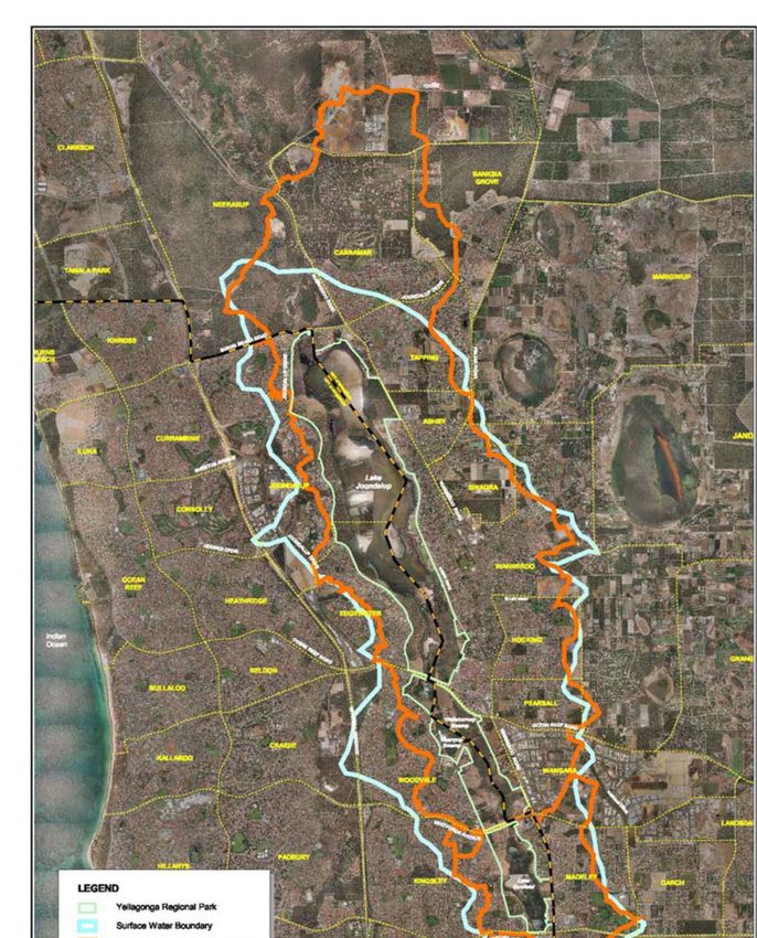
Please formally acknowledge the City of Joondalup and the City of Wanneroo if you use any of the
content contained within the Yellagonga Integrated Catchment Management Plan 2021-2026.

Suggested citation:

City of Joondalup and City of Wanneroo, 2020, Yellagonga Integrated Catchment Management Plan
2021-2026, Perth, WA.

                                                                                    P a g e 2 | 71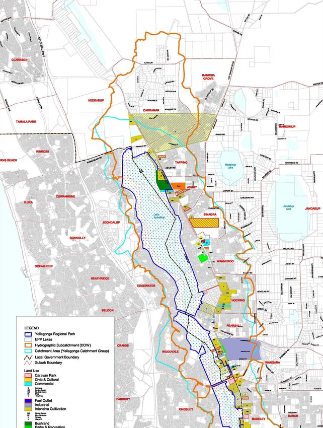
CONTENTS

CONTENTS                                                                                                                           3
ABBREVIATIONS                                                                                                                      4
EXECUTIVE SUMMARY                                                                                                                  5
1.0           INTRODUCTION                                                                                                         7
      1.1     Yellagonga Regional Park.................................................................................. 7
      1.2     Background ...................................................................................................... 11
      1.3     Yellagonga Integrated Catchment Management Plan 2021-2026 ................... 12
      1.4     Strategic Context.............................................................................................. 13
2.0           YELLAGONGA CATCHMENT AREA                                                                                          14
      2.1     Introduction ...................................................................................................... 14
      2.2     Hydrology ......................................................................................................... 14
      2.3     Water Quality ................................................................................................... 18
      2.4     Biodiversity ....................................................................................................... 23
      2.5     Threatening Processes .................................................................................... 25
3.0           IMPLEMENTATION PLAN                                                                                                36
      3.1     Key Focus Areas .............................................................................................. 36
      3.2     YICM Plan 2021-2026 Projects ........................................................................ 37
      3.3     Reporting and Review ...................................................................................... 38
4.0           PROJECT DETAILS                                                                                                    39
      4.1     Joint Projects.................................................................................................... 39
      4.2     Individual Projects ............................................................................................ 47
      Appendix 1 – Key Achievements of the YICM Plan 2015-2019 ................................. 57
      Appendix 2- Strategic Context ................................................................................... 62
5.0           REFERENCES                                                                                                         68

                                                                                                                P a g e 3 | 71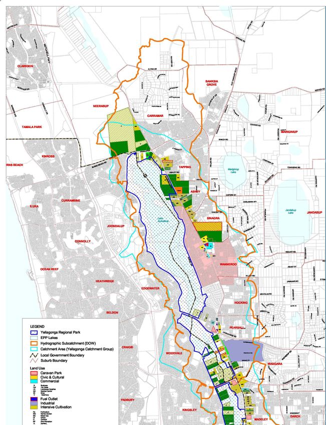
ABBREVIATIONS

ASS        Acid Sulphate Soils
BAM Act    Biosecurity and Agriculture Management Act 2007
BC Act     Biodiversity Conservation Act 2016
CoJ        City of Joondalup
CoW        City of Wanneroo
DBCA       Department of Biodiversity, Conservation and Attractions
DPIRD      Department of Primary Industries and Regional Development
DWER       Department of Water and Environmental Regulation
ECU        Edith Cowan University
EPBC Act   Environment Protection and Biodiversity Act 1999
WAPC       Western Australian Planning Commission
YICM       Yellagonga Integrated Catchment Management
YRPM       Yellagonga Regional Park Management

                                                                       P a g e 4 | 71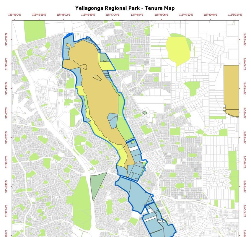
EXECUTIVE SUMMARY

Yellagonga Regional Park is one of seven regional parks within the Swan Coastal Plain and is located
approximately 20km north of Perth. Yellagonga Regional Park consists of a wetland chain including,
from north to south, Lake Joondalup, Beenyup Swamp, Walluburnup Swamp and Lake Goollelal.1 The
Yellagonga Regional Park is an area of high ecological significance including being a Bush Forever
site, having Conservation Category Wetlands, and Lake Joondalup is also a Class ‘A’ Reserve.
The Yellagonga Regional Park is jointly managed by the Department of Biodiversity Conservation and
Attractions (DBCA), and the Cities of Joondalup (CoJ) and Wanneroo (CoW); with the DBCA being
responsible for the management of the majority of the land within the Park. Land tenure is also vested
with the Conservation Commission of Western Australia, the Western Australian Planning
Commission, with small sections owned by private landholders; particularly within the southern extent
of the Park (see Figure 2).
The Park’s co-managers, the CoJ and CoW and the DBCA recognise that land use practices in the
surrounding catchment, from both past and present activities, can have detrimental effects on the
wetlands of the Yellagonga Regional Park, and it is the shared responsibility of the co-managers to
holistically address the threats impacting the health of the Yellagonga Catchment Area. Impacts
include water quality and quantity entering the wetlands, and threats to the ecological integrity and
biodiversity of the Park.
In order to maintain and enhance the amenity, recreational, educational, scientific, and conservation
values of Yellagonga Regional Park, for present and future generations, the Yellagonga Integrated
Catchment Management Plan (YICM Plan) was developed to provide a comprehensive and
integrated approach to managing the Park.
The YICM Plan has continued to provide a holistic and strategic direction for the two Cities to
implement a wide range of initiatives aimed to conserve the ecological values of the Yellagonga
Regional Park. Since the YICM Plan’s initial adoption by both Cities in 2009, the Plan was reviewed,
updated and adopted again in 2015 to provide the YICM Plan 2015-2019.
The latest review and update provides for the current Draft YICM Plan 2021-2026, a five-year life
span allows for a comprehensive review of management actions, conservation outcomes and to
assess current impacts and threats to the Yellagonga catchment. The review was undertaken in
consultation with internal and external stakeholders, including the Yellagonga Regional Park
Community Advisory Committee. The updated YICM Plan focuses on the management of key threats
to the health of the Yellagonga wetlands in response to current environmental conditions, whist
building upon the knowledge gained through the implementation of the previous versions of the Plan.
Extensive historical and technical information regarding the Yellagonga Catchment can be found in
the YICM Plan 2009-2014 Part 1 Technical Report.
A range of threats to the long-term viability of Yellagonga Regional Park remain, including the drying
climate trend, poor water quality, invasive flora and fauna species, bushfires, plant pathogens and
their spread, urban encroachment, remaining traditional stormwater drainage, habitat degradation and

1   CALM et al. (2003)
                                                                                        P a g e 5 | 71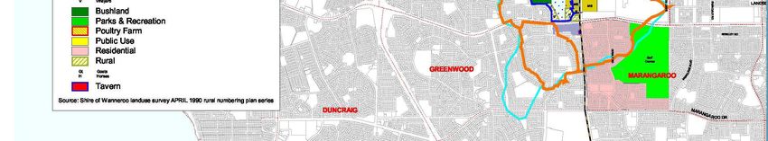
fragmentation. The projects within the YICM Plan aim to address these threats.
Significant progress has been achieved over the past five years through the YICM Plan 2015-2019 to
address the key threats to the Park. Key achievements include:
Ongoing water quality monitoring, which has produced reliable, long term water quality data
for the catchment.
The delivery of wide-ranging community education and ecotourism initiatives.
Coordinated pest animal control and conservation maintenance schedules.
The completion of flora surveys for much of the riparian vegetation around the catchment that
have informed rehabilitation projects in key locations.
Significant revegetation works in areas identified through the flora surveys.
This updated Plan aims to build upon the extensive monitoring and conversation management work
undertaken in the Yellagonga catchment area through the continued collaboration between the two
Cities and the DBCA. The Yellagonga Integrated Catchment Management Plan 2021-2026 provides
the Park’s co-managers with detailed direction required to manage the catchment area in a
sustainable manner to ensure the long-term protection of the Park for future generations.
The YICM Plan 2021-2026 will be implemented by the CoJ and CoW in partnership with the
Yellagonga Regional Park key land manager, the DBCA.
P a g e 6 | 71
1.0              INTRODUCTION

1.1        Yellagonga Regional Park
Yellagonga Regional Park is one of seven Regional Parks within the Swan Coastal Plain and lies
approximately 20km north of the Perth CBD. The Park is highly utilised for a diverse range of activities
including exercise, social and family gatherings at the various landscaped parks and play spaces, it’s
intrinsic environmental values and associated activities (such as birdwatching, wildflower spotting),
and photography.
The Park holds considerable cultural significance for the Mooro Noongar people as a place of hunting,
gathering, social, ceremonial and recreational purposes, with the Park named after Yellagonga; who
was a leader of the Wadjuk Noongar people North of the Swan River2. The location of the wetlands
made them an important site in seasonal camping cycles between the ocean and the Perth foothills,
and between Mount Eliza (King’s Park) in Perth and the Moore River to the North, part of which now
forms the Yaberoo Budjara Heritage Trail starting at Neil Hawkins Park in the Park1.
The eastern side of the Park was first settled by Europeans around 1850 and there are three sites
listed on the Western Australian Heritage Register; Perry’s Paddock, Cockman House, and Luisini
Winery. The Sorrento to Dongera Stock Route, gazette in 1889, ran through the park following the
track used by Yellagonga’s people in their journeys to the north1.
In order to maintain and enhance amenity, recreational, scientific, educational and conservation
values of the Park for present and future generations, an integrated catchment approach has been
undertaken to provide a comprehensive and integrated approach to managing the Park.

1.1.1 Yellagonga Catchment Overview
All water bodies, whether a wetland, lake or river, receive water from the surrounding area. This area
from which water flows into the water body is known as the catchment. Effective management of a
water body requires management of the surrounding catchment. Integrated catchment management
is about balancing use of the land, water and biological resources within a catchment, in a sustainable
manner, by encouraging co-operation and co-ordination at all levels of government, in collaboration
with the whole community on management of these resources.1
The Park consists of a wetland chain including, from north to south, Lake Joondalup, Beenyup
Swamp, Walluburnup Swamp and Lake Goollelal which are all recognised as being Conservation
Category Wetlands with Lake Joondalup also being a Class ‘A’ Reserve.1 By taking an integrated
catchment management approach to these wetlands, the CoJ, the CoW and the DBCA recognise that
activities outside of their respective management areas will impact on the ecological integrity and
biodiversity of the Park and the wetlands holistically, particularly through the movement of
groundwater, surface water and stormwater.
Any land use within the catchment will impact to some extent on the quality and quantity of water
entering the Park’s wetlands, as well as impacting on floristic and faunal communities within the Park.
The catchment has a diverse range of current land uses comprised of residential developments,

2
    McGuire, M. I. (1996)
                                                                                        P a g e 7 | 71
market gardens, aged care, grassland, orchards, poultry farms, horse agistment, pine tree lots, plant
nurseries and various commercial developments (car yards, service stations, shopping centres etc.),
all of which can impact on the Park.
Figure 1 Location of the Yellagonga Regional Park1
The health of the Park and its wetlands is of high importance to both the local and wider communities
as well as the stakeholders and organisations responsible for the management of the Park. The Park
is identified as having significant regional value, particularly for:
Providing habitat for flora and fauna including iconic local species such as the South-western
Snake-necked Turtle (Chelodina colliei), Carnaby’s Black-Cockatoo (Calyptorhynchus latirostris)
and Quenda (Isoodon fusciventer).
A Bush Forever site (299) registered by the Western Australian Planning Commission as
containing regionally significant vegetation.
Improving ecological function such as air quality, carbon capture, and soil health.
Decreasing erosion, salinity, water pollution and noise pollution.
P a g e 8 | 71
Providing opportunity for recreational and cultural experiences.
In order to maintain and enhance amenity, recreational, scientific, educational and conservation
values of the Park for present and future generations, an integrated catchment approach has been
undertaken to provide a comprehensive and integrated approach to managing the Park.
1.1.2 Tenure and Management Arrangements
The Yellagonga Regional Park is composed of land that is owned and managed by a number of
different bodies. Lands owned by the Western Australia Planning Commission, those vested in the
Conservation Commission of Western Australia, and Unallocated Crown Land are managed by the
DBCA, with the CoJ and CoW having management orders over small areas of Crown Land within the
Park; predominantly areas designated for recreation. There is also a small portion of land that remains
privately owned with individual landholders responsible for the management of their own property.3
The lakes themselves are managed by the DBCA.
Areas directly managed by the City of Joondalup equate to 13 hectares (Ha). These include Neil
Hawkins Park (4.2Ha), Neil Hawkins Natural Area (4.7Ha), and Picnic Cove Park (4.1Ha).
Areas directly managed by the City of Wanneroo equate to approximately 50Ha. These include
Studmaster Park (2Ha), Poinciana Park (2.5 Ha), Ariti Ave Foreshore (1.5 Ha), Scenic Park (10 Ha),
Rotary Park (6.5 Ha), Banyandah Park and Foreshore Reserve (7.8 Ha), and Lake Joondalup
Foreshore Reserve North of Rotary Park (17.3 Ha).
The balance of land is managed by the DBCA.
While the land tenure for the Park is varied (see Figure 2), the integrated management of the Park is
shared by the DBCA and the Cities of Joondalup and Wanneroo in line with the Yellagonga Regional
Park Management (YRPM) Plan 2003-2013. Effective environmental management requires working
beyond management borders to address the threats to the Park holistically. Management actions
throughout the Park must be undertaken in a coordinated approach with the Cities working together
with the DBCA to undertake work on land managed by the DBCA, in addition to the land where the
Cities possess management orders.
In addition, there are a number of community groups, including conservation groups who contribute to
the management of the Park, in particular the Friends of Yellagonga Regional Park and the Woodvale
Waters Friends of Beenyup Channel Group.
3 CALM et al. (2003)
P a g e 9 | 71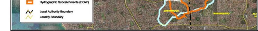
Figure 2 Land Tenure in Yellagonga Regional Park (DBCA 2020)

                                                               P a g e 10 | 71
1.2 Background
This Yellagonga Integrated Catchment Management Plan 2021-2026 has been developed within the
context of the YRPM Plan 2003-2013 as well as the previous two versions of the YICM Plan 2009-
2014 and 2015-2019. The sections below provide background information on these previous plans
and how they relate to the current YICM Plan 2021-2026.
1.2.1 Yellagonga Regional Park Management Plan 2003-2013
The YRPM Plan 2003-2013 was developed by the then Department of Conservation and Land
Management (now DBCA) and the CoJ and the CoW, “to provide broad direction for the protection
and enhancement of the conservation, recreation and landscape values of Yellagonga Regional
Park”. One of the ‘High Priority’ strategies proposed in the Management Plan was the preparation of
an integrated catchment management plan which was to be consistent with the overall direction of the
YRPM Plan 2003-2013.4
The YICM Plan 2021-2026 addresses the activities being undertaken within the catchment that affect
the Park, while management of the Park itself is guided by the YRPM Plan 2003-2013.
The YRPM Plan 2003-2013 is still considered current in its content and management strategies and
therefore is still being utilised to guide the management of the Yellagonga Regional Park.
1.2.2 Yellagonga Integrated Catchment Management Plan 2009-2014
The development of the initial YICM Plan 2009-2014 and associated catchment management projects
was initiated through a Partnership Agreement between the CoJ and the CoW, who jointly funded the
project and involved considerable input from the community and key stakeholders. This included two
community workshops and the establishment and involvement of a Community Reference Group and
a Technical Working Group. Key stakeholders included Friends of Yellagonga, Edith Cowan
University, the then Department of Environment and Conservation (now DBCA) and the then
Department of Water (now Department of Water and Environmental Regulation - DWER).
The YICM Plan 2009-2014 comprised of two parts. Part 1 provided a technical report on the research
and information collected during the two-year planning process and provided an assessment of the
health of the Park and the catchment area. Part 2 provided an Implementation Plan and included 18
projects to be implemented within the catchment over the life of the Plan, to mitigate the key
threatening processes and issues identified within the Yellagonga Regional Park.
Substantial progress was made in implementing the YICM Plan 2009-2014 which resulted in the
continued implementation of the updated YICM Plan 2015-2019.
1.2.3 Yellagonga Integrated Catchment Management Plan 2015-2019
Following the implementation and review of the YICM Plan 2009-2014 a new Plan to guide
management of the Yellagonga Catchment was developed. The YICM Plan 2015-2019 built upon the
progress made during implementation of the first Plan and provided further management
recommendations to ensure the long-term protection of the Yellagonga Regional Park with a focus on
addressing the current and future impacts of climate change. Key highlights of the YICM Plan 2015-
2019 can be found in the Appendices of this document.
4 CALM et al. (2003), pp.1‐2
P a g e 11 | 711.3 Yellagonga Integrated Catchment Management Plan 2021-2026
The updated YICM Plan 2021-2026 expands upon the successes and lessons learnt from the two
Plans before it by continuing with projects that have proven to be of benefit to the health of the
wetlands. Projects have been updated where necessary in order to ensure they remain relevant to the
current environmental conditions of the Park and surrounding areas.
The updated Plan ensures the continued collaborative delivery of the projects that have proven to be
effective in monitoring and improving the health of the Yellagonga wetlands.
1.3.1 Aim and Objectives of the Plan
The aim of the YICM Plan 2021-2026 is to provide a holistic and long-term strategic plan to improve
catchment health and protect the diverse values of the Park.
The objectives of the YICM Plan 2021-2026 are:
Objective 1: To build upon the achievements, experiences and outcomes of the YICM Plan 2015-
2019 and continue to implement an integrated and effective approach to catchment
management.
Objective 2: To work in partnership with key stakeholders to improve catchment management and
protect and enhance the ecological values of the Yellagonga Regional Park.
Objective 3: Ensure positive environmental, social and economic outcomes for the Yellagonga
Regional Park and its wetlands.
Objective 4: Consider the long-term protection of the Yellagonga Regional Park with a focus on
addressing the current and future impacts of climate change.
1.3.2 Scope of the Plan
The YICM Plan aims to build upon the outcomes of the previous Plan to provide a guide for continuing
to implement an integrated catchment management approach for the Yellagonga Catchment Area. As
such the YICM Plan 2021-2026 will:
Continue to use the outcomes of the original community consultation process and technical
review of scientific literature to inform its implementation.
Provide a brief overview of the Yellagonga Catchment and its environmental condition.
Outline key achievements from the implementation of the YICM Plan 2015-2019.
Identify new and ongoing projects that continue the integrated catchment management
approach.
Provide opportunity for stakeholder and community input into the delivery of projects within
the YICM Plan 2021-2026.
Responsibility for implementation of the YICM Plan 2021-2026 lies primarily with the Cities of
Wanneroo and Joondalup. The DBCA is a key partner in the delivery of a number of projects within
the Plan that relate to the health of ecosystems within Yellagonga Regional Park. The implementation
of the Plan will be more effective if strong partnerships with other government bodies including DBCA,
educational institutions and the local community are maintained.
In 2013 the Yellagonga Catchment Working Group, comprising of representatives from the Cities of
Joondalup and Wanneroo and DBCA, was established to assist communications and commitment in
P a g e 12 | 71working collaboratively on the YICM Plan. The Yellagonga Catchment Working Group focuses on key
projects requiring collaboration from the three managing agencies and will continue ensuring the
timely and effective implementation of the updated Plan.
1.4 Strategic Context
The management of the Yellagonga wetlands catchment and the implementation of the YICM Plan
2021-2026 needs to consider the strategic context in which it operates including international
legislation, Federal policy and legislation, State policy and legislation, regional policy and local law
and policy. Details of the relevant local, State and Federal plans and strategies are provided in
Appendix 2.
P a g e 13 | 712.0 YELLAGONGA CATCHMENT AREA
2.1 Introduction
The Park’s catchment lies on the Swan Coastal Plain and is located approximately 20 km north of
central Perth. The surface water catchment area impacting on the Park is estimated to cover an area
of approximately 4000 hectares.5 The catchment is linked to the Park by surface flows via drainage
infrastructure and groundwater flows. The catchment encompasses land on either side of the Park
located in the Cities of Joondalup and Wanneroo and includes medium to high-density residential,
commercial and light industrial development interspersed with green areas. Lakes Joondalup and
Goollelal, and the swamps Beenyup and Walluburnup, are the receiving aquatic environments for
water from this catchment via surface and groundwater flows.
Climate of the Swan Coastal Plain is described as being Mediterranean characterised by long hot dry
summers and a shorter period of wet winter months. The annual mean maximum temperature is
24.8°C and the annual mean minimum temperature is 12.8°C. The hottest months are January
(average of 31.2°C) and February (average of 31.6°C). The mean annual rainfall is 733.2mm with the
wettest months being June (127.8mm) and July (144.5mm).6
Soils and geology of the Perth metropolitan north-west corridor have been described by McArthur and
Bartle (1975-76). They describe the Park and catchment as lying over quaternary deposits known as
the Spearwood Dune System, which presents as a low hilly and undulating landscape. The wetlands
and surrounding catchment lie predominantly over Spearwood sand with some areas of Karrakatta
limestone and Karrakatta sand. The Spearwood sands consist of some limestone outcrops with
shallow brown soils and the Karrakatta limestone is characterised by bare limestone or shallow
siliceous or calcareous sand over limestone. The Karrakatta sand is yellow, and limestone usually lies
beneath this layer.7
A brief outline of the features of the Yellagonga Catchment and Regional Park are detailed below. Full
details of the key components of the Yellagonga Catchment can be found in the YICM Plan 2009-
2014 Part 1 Technical Report.
2.2 Hydrology
2.2.1 Groundwater Flow and Levels
Groundwater flows from northeast to southwest across the Swan Coastal Plain towards the Indian
Ocean.8 Inputs into the groundwater from land uses many kilometres to the east could eventually see
impacts on the Park’s wetlands. While a groundwater catchment boundary has not been fully defined,
strategies can still be developed to address potential land use impacts on groundwater - particularly
given the high groundwater recharge rates found on the Gnangara Mound. The highest recharge
rates occur over the Gnangara Mound, and range from 15-20 percent, reaching as high as 40 percent
5 Ove Arup and Partners (1994)
6 Bureau of Meteorology (2019)
7 McArthur and Bartle (1975‐76)
8 Department of Environment (2004)
P a g e 14 | 71of rainfall as total net recharge,9 which highlights the rapidity that any contaminants from land use
over the Gnangara Mound may leach to groundwater.
Steep groundwater gradients occur to the east and west of the lake system and are steepest on the
west side of the wetland system, becoming shallow heading west towards the ocean.10 Given the
relatively slow rate of groundwater flow, residence time of groundwater has implications for pollutant
concentrations held within the lake systems.
2.2.2 Surface Water
Wetlands on the Swan Coastal Plain are generally surface expressions of an unconfined aquifer with
water levels reflecting the rising and falling groundwater levels.11 In the past, Lakes Joondalup and
Goollelal have fluctuated and followed natural cycles of drying and filling, displaying patterns of long-
term seasonal fluctuations according to climatic conditions.12 However in more recent times, Hamann
(1992) suggests the wetlands are not exact surface expressions of the Gnangara groundwater system
due to seasonal fluctuations in wetland depth that does not match seasonal changes in the
groundwater table. The research has suggested that since urbanisation post 1975, an increasing
volume of surface water has entered the wetlands via impervious and cleared surfaces, resulting in
deeper lake systems. The drying climate trend however indicates that there will be reduced surface
water expression from groundwater and rainfall. Figure 3 provides an indicative surface water
catchment boundary and the three DWER hydrographic subcatchments for the Park.
9 Department of Water (2008a)
10 Congdon (1979)
11 Allen (1976)
12 Hamann (1992)
P a g e 15 | 71Figure 3 Indicative Surface Water Catchment Boundary 2008
P a g e 16 | 71Surface flow through the Park’s wetlands moves from south to north, but, as this habitat is now
separated by roads dividing it into three sections; culverts and tunnels have been constructed to
enable the surface water flow to mimic the natural hydrological regime. Water drains from Lake
Goollelal into Walluburnup Swamp via a culvert under Hocking Road and Whitfords Avenue and flows
north into Beenyup Swamp. Ocean Reef Road bisects Lake Joondalup into north and south sections.
Flow between the two sections only occurs during the winter months via a culvert. There is no surface
outflow from this wetland chain, but outflow occurs via groundwater in an east to west direction.13
2.2.3 Drainage
In a natural system, rainfall would infiltrate directly to groundwater with limited overland flow to
wetlands. However, urbanisation has resulted in constructed roads and other impervious surfaces
with traditional piped drainage networks and altered topography causing a significant alteration to the
natural hydrological regime. For the Park’s wetlands urbanisation has resulted in increased surface
water run-off through drainage networks bringing with it polluted water.14
In the current climate of diminished rainfall, increased evaporation and a reduction in recharge to
groundwater, impervious surface contributions can be viewed as vital arterial flows for many wetlands,
however the wetland ecology would require uncontaminated water entering the lakes.
2.2.4 Stormwater Drains
Stormwater drains are known to contribute significant nutrient loads into wetlands. There are 36
drainage outfalls into the Park, including piped outfalls, swales, sumps, and constructed wetlands.
The CoW manages 22 drains, and the CoJ manages 14. Main Roads Western Australia also
manages drains and sumps along Wanneroo Road. Several of these drains feed directly into CoW
drains, which eventually lead into the Park’s wetlands.
The CoJ upgraded all outfalls within the City’s boundaries that discharged directly into the Yellagonga
Wetlands prior to the YICM Plan 2009-2014. This involved redirecting outfalls away from the wetlands
with filtering systems. Although the remaining stormwater catchment points are sumps that do not
discharge directly into the Park’s wetlands, the City has identified the upgrade of these sumps in the
Stormwater Drainage Program – Sump Beautification Program to consider for best environmental
outcome.
The CoW commenced the retrofitting of stormwater infrastructure in 2009, beginning with the
Wangara Industrial Area. Further investigations into the most viable upgrades to the stormwater
infrastructure have commenced and will be undertaken over the next few years.
13 Ove Arup and Partners (1994)
14 Kobryn (2001)
P a g e 17 | 712.3 Water Quality
2.3.1 Pollutants
Contaminants such as heavy metals, surfactants, hydrocarbons, nutrients, suspended solids, litter
and pesticides are common substances in urban wetlands.15,16,17 Pollutants and contaminants enter
the Park’s wetlands via stormwater run-off, groundwater flow and, to a lesser extent, rainfall.
Key water quality issues arising from pollutants that can impact on the Park’s wetlands include:
• Nutrient enrichment resulting in eutrophication, algal blooms and midge outbreaks.
• Pollutants from toxicants (heavy metals, petroleum products, pesticides and herbicides,
industrial and household chemicals) can cause compromised immune systems for
wetland fauna, mutations, hormone disruption, reproductive interference, poisoning,
injury, and death.
• Pollutants bound to sediments can be re-released in water leading to the mobility of these
contaminants throughout food chains with unknown effects of bioaccumulation on wetland
fauna. For example, heavy metals are mobilised under acidic conditions.
• Sedimentation and suspended solids reduce light penetration leading to restricted plant
growth and smothering of flora and fauna.
• Litter is unsightly and can reduce light reaching some plants, with unknown effects of
dyes and chemicals from printed materials, and possible choking / ingestion hazards for
some wetland fauna such as freshwater turtles, macroinvertebrates and avian fauna.
The legacy issues of past land uses are considered to have an ongoing adverse impact on the Park’s
wetlands; these include market and commercial gardens, poultry industries and septic tanks (See
Figures 4 and 5).
The Wangara Industrial Area is a current land use that may potentially have an adverse impact on the
water quality of the Park’s wetlands. Untreated stormwater has been draining into a compensating
basin (the Wangara Sump) on the boundary of Walluburnup Swamp; though initial analysis through
the Water Quality Monitoring and Improvement Program indicates the Wangara Sump is unlikely to be
a major source of contaminants into the wetlands. The stormwater drainage infrastructure in this
industrial area is in the process of being retrofitted in order to filter and redirect stormwater away from
the Yellagonga Wetlands. Other present land uses include market gardens, septic tanks, diverse
commercial uses, residential areas and the high use major and minor roads, which surround the Park.
Some drainage subcatchments accommodate significantly more potentially polluting land uses than
others as indicated in Figure 7. Pollutants potentially arising from these land uses can also enter the
Yellagonga wetlands via groundwater movement.
15 Davis et al. (1993)
16 Bunny and Mouritz (1995)
17 Whitely (2004)
P a g e 18 | 71Figure 4 Past Land Uses to the East of Yellagonga Regional Park in 1979
P a g e 19 | 71Figure 5 Past Land Uses to the East of Yellagonga Regional Park in 1990
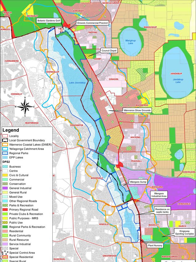
P a g e 20 | 71Figure 6 Current Land Uses to the East of Yellagonga Regional Park (2020)
P a g e 21 | 71Figure 7 Drainage Sub-catchments in the Yellagonga Catchment Mapped 2008
P a g e 22 | 712.3.2 Monitoring
Research and monitoring programs of surface and groundwater quality have been undertaken in the
Park and in the surrounding catchment by the Edith Cowan University (ECU) Mine Water and
Environment Research Centre (MiWER), since the initial implementation of the YICM Plan 2009-2014
which included the Water Quality Monitoring Program and the Midge Steering Group Partnership
Research projects.
Ongoing monitoring and research have continued to indicate high concentrations of nutrients and
heavy metals in the surface and groundwater of the Yellagonga Wetlands that have exceeded the
Australian and New Zealand Environment Conservation Council guideline values (risk to
environment). Groundwater has been identified as a major source of nutrients and some metals into
the wetlands, particularly through Beenyup Swamp.
The source of metals around a drain site north of Whitfords Avenue has been identified as being from
acid sulphate soils, as well as from Lake Goollelal where low water levels have resulted in some
acidification of the Lake’s sediments.
On the ground initiatives have commenced following recommendations from the ECU MiWER
including site specific acid sulphate soil investigations and revegetation works within the riparian zone
of the wetlands.
The ongoing implementation of the Yellagonga Water Quality Monitoring Program is included within
the YICM Plan 2021-2026 to continue to provide consistent and comprehensive water quality data,
analyses and recommendations upon which sound management decisions can be made.
2.4 Biodiversity
2.4.1 Flora
The vegetation communities within the Park have been identified as nine wetland communities
(consisting of sedgelands, woodlands, open and closed forests) and five dryland communities
(consisting of open and closed forest as well as woodlands). Much of the remnant vegetation has
been altered with only a small area identified as in ‘Pristine’ condition (according to the Keighery
Scale 1994) in 2002 in the northern-most section of the Park, found in the Melaleuca
rhaphiophylla/Eucalyptus rudis closed forest community, more recent surveys undertaken in 2015 by
Eco Logical Australia identified these areas as ‘Excellent’. Weeds remain a key threat in the Park.18
Three types of emergent vegetation exist within the Park; Baumea articulata, Schoenoplectus validus,
and the Giant Reed Typha orientalis, which was previously considered an introduced species was
reclassified as being native to Western Australia by Keighery and McCabe in 2015. Typha is capable
of aggressive invasion and can transform wetland ecosystems largely as a result of landscape
modifications. Typha can rapidly change nutrient levels and water levels and flow, requiring active
management to prevent it from becoming a weed19.
A clearing permit or exemption is required to undertake Typha control within its natural range,
however exemptions under Schedule 6 Clause 3 of the Environmental Protection Act 1986 (EP Act)
allow the DBCA (including volunteers, and contractors) to undertake control works on DBCA managed
18 Regeneration Technology (2002)
19 Keighery, G (2016)
P a g e 23 | 71land, such as in the Yellagonga Regional Park without requiring a permit. 20 21 22
Fringing vegetation around the wetlands is fragmented, with some decline in Eucalyptus rudis and
Melaleuca rhaphiophylla observed at Lake Goollelal as well as Lake Joondalup23. Weed invasion is
also evident in the understorey, such as the highly invasive introduced grasses Kikuyu (Pennisetum
clandestinum), Buffalo (Stenotaphrum secundatum) and Couch (Cynodon dactylon).24
A high proportion of the dryland vegetation that once surrounded the Park has been cleared in order
to support past and existing land uses such as agriculture and residential development. Tuart-Jarrah-
Marri (Eucalyptus gomphocephala - Eucalyptus marginata - Corymbia calophylla) open forest exists
as a patchy distribution in the west with some open forest to the north east of Lake Joondalup, with
scattered Tuarts to the east of Walluburnup and Beenyup Swamps and northeast of Lake Goollelal.
Banksia, Jarrah and Marri exists in an open forest along much of the southeastern shore of Lake
Joondalup with large areas cleared for recreational landscape along the eastern shores of
Walluburnup and Beenyup Swamps and Lake Goollelal.25
Indicative DBCA Threatened Ecological Community distribution mapping from 2019 shows areas of
the Park are likely to contain Environmental Protection and Biodiversity Conservation Act 1999 (EPBC
Act) listed Threatened Ecological Communities (TEC), including: Banksia Woodlands of the Swan
Coastal Plain, listed Priority 1 in WA and Endangered TEC under the EPBC Act, in patches of the
eastern and southern areas of the Park, and Tuart (Eucalyptus gomphocephala) woodlands of the
Swan Coastal Plain, listed Priority 3 in WA and Endangered TEC under the EPBC Act, in patches
along the western side of the Park.
2.4.2 Fauna
A formal register of fauna in the Park does not currently exist, however, it is known that within the
surface water catchment boundary, at least seven sites with threatened fauna have been identified
and many others further east of the boundary have been listed by the DBCA. Two sites have been
identified with threatened fauna within the Park.
Through the Atlas of Living Australia data base (accessed 2019) seven snake species have been
identified within the Park including the Tiger Snake (Notechis scutatus), Carpet Python (Morelia
spilota) and Dugite (Pseudonaja affinis)26. Fifteen lizard species (including Geckos, Monitor Lizards,
and Legless Lizards) have also been identified such as the Australian Scincid Lizard (Ctenotus
fallens), Bar-shouldered Ctenotus (Ctenotus inornatus), Yellow-bellied Skink (Hemiergis peroni),
Burton’s Legless Lizard (Lialis burtonis), as well as the Bobtail Lizard (Tiliqua rugosa).27
The South-western Snake-necked Turtle (Chelodina colliei – formerly Chelodina oblonga) exists
within the lake systems. In temperate wetlands, freshwater turtles are top end predators and their
overall health and presence is important in wetland ecology.
20 Keighery, G. (2016)
21 DBCA (2019)
22 CALM et al. (2003)
23 Department of Water (2008b)
24 CALM et al. (2003)
25 Regeneration Technology (2002)
26 Atlas of Living Australia (2019)
27 Atlas of Living Australia (2019)
P a g e 24 | 71In surveys undertaken in 2011 Syrinx identified seven frog species including the Squelching Froglet
(Crinia insignifera), Clicking Froglet (Crinia glauerti), Moaning Frog (Heleioporus eyrei), Western
Banjo Frog (Limnodynastes dorsalis), Slender Tree Frog (Litoria adelaidensis) and the Western Bell
Frog (Litoria moorei).28
Mammals that have been sighted in the Park include the Western Grey Kangaroo (Macropus
fuliginosus), Quenda (Isoodon fusciventer), Brushtail Possum (Trichosurus vulpecula), Short-beaked
Echidna (Tachyglossus aculeatus) and the Native Water-rat, known as Moyitj or Rakali in Aboriginal
languages (Hydromys chrysogaster). A number of species of microbat have also been recorded
including the Gould’s Wattled Bat (Chalinolobus gouldii) and White-striped Freetail Bat (Tadarida
australis).31 The Western Brush Wallaby (Notamacropus irma) has also historically been recorded in
the Park29. Foxes, rabbits, and feral and roaming cats are pest mammals present in the Park and are
discussed in 2.6.8 Introduced Animals.24
Five fish species have been observed in the Yellagonga lake systems; two native, and three exotic.
Native species recorded are the Swan River Goby (Pseudogobius olorum) and the Western Pygmy
Perch (Edelia vittata).30 The exotic fish being the Mosquito Fish (Gambusia affinis), the European
Carp (Cyprinus carpio), and Goldfish (Carassius auratus).31
The Park is important as a summer refuge and breeding habitat for many resident and trans-
equatorial migratory water bird species.31,32 Over 120 avian species have been recorded in the Park.31
Bekle (1997) identified at least 37 water bird species during 1991-1993 (from the families: Anatidae,
Podicipedidae, Anhingidae, Phalacrocoracidae, Pelecanidae, Ardeidae, Plataleidae, Rallidae,
Scolopacidae, Recurvirostridae and Charadriidae). Combined results of surveys suggest there may
be a decline in water bird species utilising the Park’s wetlands. In addition to the water bird species
found in the Park, there were 47 species of terrestrial birds identified in the park by Bamford and
Bamford (1990).
Kinnear and Garnett (1997a) identified 121 macro-invertebrate taxa excluding the segmented worms
(Annelida). The dominant groups were the ten-legged animals (from the order Decapoda such as
shrimps and the small crustaceans) and true flies (from the order Diptera such as midges).
Considerable variability was found in distributions of macro-invertebrates throughout the wetlands,
both spatially and temporally, but the greatest diversity and abundances of macro-invertebrates were
typically found at South Lake Joondalup and Beenyup Swamp.
2.5 Threatening Processes
2.5.1 Climate Change
Current Climate Change
The climate of south-west Western Australia has been undergoing significant change in recent
decades. These changes include increased temperatures, increase in sea levels, decrease in rainfall,
28
Bamford and Bamford (1990)
29 CALM et al. (2003)
30 WAWA (1995)
31 CALM et al. (2003)
32 Bekle (2007)
P a g e 25 | 71more intense storm events and increased storm surge.
The long-term trend in temperature for south-west Western Australia has been increasing over the
past century, with the rate of warming higher since 196033. In 2019 the mean annual temperature for
Perth was 1.8°C above the long term (1961-1990) average and was the warmest year on record
(since 1944)34.
There have also been greater temperature extremes. The mean number of days over 35°C between
1944 and 2014, was 27.5, between 1981–2010 it was 28.5 and in 2019 there were 3737. In 2019 Perth
Airport recorded three consecutive December days over 40°C and doubled its previous highest
number of 40°C days35.
There is a strong drying trend between May to July over south-west Western Australia, with rainfall
since 1970 around 20% less than the average between 1900 and 1969. Since 1999, this reduction
has increased to around 26%36. In 2019 Perth Airport recorded 524.6 mm which was its fourth-driest
year since records commenced in 1944 and driest since 201038. These changes have already
impacted on the Yellagonga catchment and as a result, management responses will have to adapt
accordingly.
Future Climate Change
Climate change is expected to continue although the extent of change will be dependent on both the
amount of greenhouse gases that continue to be emitted and how the environment responds. Future
projections have been developed by the Commonwealth Scientific and Industrial Research
Organisation (CSIRO) and Bureau of Meteorology (BoM) which indicate that for the south-west of
Western Australia temperatures will continue to increase while rainfall decreases36. Further details on
these projections are provided in Table 1.
33
Hope et al. (2015)
34
BoM (2020a)
35
BoM (2020b)
36
BoM, and CSIRO (2018)
P a g e 26 | 71Table 1 Future Climate Change Projections for south-west Western Australia (Adapted from Hope et al.
2015)
2030 2090
0.5 – 1.2°C TEMPERATURE 1.1 – 2.1 °C TEMPERATURE
(intermediate emissions scenario)
2.6 – 4.2 °C TEMPERATURE
(high emissions scenario)
EXTREME HEAT DAYS at a similar rate to mean temperature with a substantial
increase in the temperature reached on hot days, the frequency of hot days, and
duration of warm spells
15% WINTER RAINFALL 30% WINTER RAINFALL
(intermediate emissions scenario)
45% WINTER RAINFALL
(high emissions scenario)
INTENSITY OF EXTREME RAINFALL EVENTS (medium confidence)
Time spent in DROUGHT over the course of the century (high confidence)
CLIMATE CHANGE will result in harsher fire weather climate in the future (high
confidence)
Climate Change Impacts
Predicting the exact scale and nature of climate change at a local level and the resulting impacts is
challenging and will depend on the response of local climate systems and the level of future
greenhouse gas emissions. The Yellagonga wetlands are situated within the south-west corner of
Western Australia, a global biodiversity hotspot and an area particularly vulnerable to climate change.
Expected climate change impacts for Yellagonga wetlands are summarised in Table 2 adapted from
the 2011 Report Card on Climate Change and Western Australian Aquatic Ecosystems developed
through the National Climate Change Adaptation Research Facility.37
37 NCCARF (2011)
P a g e 27 | 71Table 2 Expected Climate Change Impacts and Potential Ecological Consequences for Yellagonga Wetland
(Adapted from NCCARF, 2011)
Anticipated Physical and Chemical
Key Stressors Potential Ecological Consequences
Changes
Reduced rainfall Reduced water entering aquatic Overall reduction in biodiversity.
ecosystems via rain, surface runoff or
Reduced runoff groundwater inflow. Progressive change from aquatic to
terrestrial species and habitats.
Declining Less internal water movement.
groundwater Local shifts in species composition.
Increased average and maximum Sensitive species may be lost due to
Increased water temperatures. changes in water availability,
temperature temperature, and water quality.
Increased evapotranspiration due to Increase in temperature tolerant
Changes to higher temperatures. species, existing pests and exotic
seasonality warm-water species.
Changes in rates of chemical
processes and equilibria. Potential extinctions of endemic
species unable to cope with the rate
Reduction in extent, depth and of change, especially those with poor
volume of wetlands and waterways. dispersal mechanisms or in habitats
affected by human activity.
Permanent systems becoming more
seasonal and seasonal systems Plant productivity will be affected by
becoming episodic or disappearing. changes in temperature, water quality
and higher CO2 concentrations.
Altered water regime (e.g. delayed
onset of winter filling, premature Potential increase in algal blooms,
drying, extended dry spells, and anoxia and fish kills. Potential
unseasonal rainfall due to cyclonic increase in midges and mosquitoes.
activity).
Potential disruption of reproductive
Changes to water quality due to cycles of biota. Changes to seasonal
changing quantity and quality of migration triggers. Depletion of seed
inflows. and egg banks.
Acidification through oxidation of acid Altered nutrient and carbon cycles.
sulphate soils (due to reducing water
levels) and associated release of
metals.
Increased fire risk (frequency and
intensity).
P a g e 28 | 712.5.2 Declining Water Levels
Most wetlands on the Swan Coastal Plain, including those in Yellagonga Regional Park, are
groundwater-dependent ecosystems. The seasonal and longer-term fluctuations in wetland water
levels reflect the fluctuations in the underlying Superficial aquifer (the water table). In turn, the
Superficial aquifer responds to the seasonal and inter-annual variability in rainfall, and to impacts from
groundwater pumping and changes in land use. The drying climate and abstraction of groundwater
from the Gnangara groundwater system has resulted in long-term declining groundwater levels in
some parts of the system. However, in the Yellagonga Regional Park, groundwater levels have been
somewhat buffered from the declines seen elsewhere, partly due to its predominantly urban setting
and the additional local recharge to groundwater because of the urbanisation.
Water levels at Lake Joondalup have increased in recent years and are currently the highest they
have been since the mid-1990s. Water levels at Lake Goollelal have fluctuated over time but are
currently similar to levels recorded in the late 1980s.
Though summer minimum levels at both lakes have improved in recent years, low minimum levels
occurred at the lakes in years following dry winters (such as those recorded in 2011 and 2016). Water
quality monitoring showed an increased risk of acidification at both lakes in these years of low
minimum levels. However, since 2016 these risks have abated as minimum levels have improved.
Wetland vegetation condition has been monitored every few years at Lakes Joondalup and Goollelal
since the mid-1990s. The most notable change to vegetation health at the monitored sites has been
the increased abundance of weed species, a common impact for wetlands in urban settings.
Local groundwater use near the Yellagonga Regional Park includes City irrigation of public open
space, commercial irrigation for horticulture in rural areas east of the park and garden bore use by
local households.
There is potential for the water levels of the Yellagonga wetlands to be positively impacted by planned
development in East Wanneroo. Groundwater modelling projects that groundwater levels are likely to
rise as a result of a combination of increased recharge from urbanisation and reduced abstraction as
agricultural land uses begin to move out of the area (Department of Water and Environmental
Regulation, Pers. Comms).
2.5.3 Weeds
Weeds are undesirable plants and include exotic plants from overseas and native Australian plants
from other regions within Western Australia, or from other parts of Australia outside of Western
Australia.38 These weeds may also be known as environmental or declared weeds. Given the highly
altered landscape of the Yellagonga catchment, invasion of weeds from the catchment into the Park is
an ongoing problem. In addition, given the extent of weed growth in the Park, propagation of weeds
from within the Park also pose a threat to the ecological integrity of the Park.
Weeds can produce structural and compositional changes to the vegetation, degrade fauna habitat,
and threaten persistence of fauna within the Park. Weeds also invade disturbed habitat, dominating
post-fire succession and, in turn, promote susceptibility to fire re-occurrence.
Through the flora surveys undertaken under the YICM Plan 2015-2019 a number of significant weed
species have been identified within the Park including Bridal Creeper (Asparagus asparagoides)
38 Keighery (2002)
P a g e 29 | 71which is a Weed of National Significance, and three species classified as Declared Pests under the
BAM Act; Arum Lily (Zantedeschia aethiopica), Apple of Sodom (Solanum linnaeanum), and One-
leafed Cape Tulip (Moraea flaccida)39. Targeted control of priority weeds is a critical part of the on-
going management of the Park.
2.5.4 Acid Sulphate Soils
Acid sulphate soils (ASS) are found naturally in the environment and are common around coastal
areas, although they do occur inland. Coastal ASS are the result of historic sea level rises, in
particular sea level rises during the Holocene (within the last 10,000 years), where sulphate in the
seawater mixed with land sediments containing iron-oxides and organic matter forming extensive
areas of iron sulfides. When these iron-sulfide rich soils and sediments come into contact with air (for
example, through dewatering, excavation, lowered water table etc.), the iron sulfides react with water
and oxygen to form iron compounds and sulfuric acid.40
In Western Australia, ASS typically occurs in water-logged conditions with soil types that include peat,
pale grey Bassendean/Spearwood sands, or coffee rock and also in dark organic rich soils/muds.
Soils of the Park and catchment are described as Potential Acid Sulphate Soils, with soils around the
Park predicted to be Class 1 ‘High Risk ASS’ occurring within 3m of the soil surface.
Disturbance of ASS results in acidification of surface waters, groundwater aquifers and the soil.
Acidification enhances the mobility of metals,41 in particular, aluminium and arsenic, which are highly
toxic to wetland flora and fauna with potential impacts on human health. Acidic conditions in surface
and groundwater can cause damage to infrastructure such as retaining walls, boardwalks, private
dwellings as well as death of aquatic organisms in acidified wetlands.
Site specific ASS investigations have been undertaken for the two Cities, with some further
investigation likely to be carried out through the Water Quality Monitoring and Improvement Program
within the YICM Plan 2021-2026.
2.5.5 Plant Diseases
Plant pathogens are organisms such as bacteria, viruses, and fungi which cause disease in plants.
Pathogens may be native or introduced and can be transported into and within a site through the
movement of soils and plant materials 42. The impact, and expression of pathogens differs based both
on the species of pathogen and the host plant, as well as environment, and climatic condition 43.
Dieback is a disease caused by introduced soil-borne water mould species from the Genus
Phytophthora, most notably P. cinnamomi, commonly referred to as ‘dieback,’ which destroys many
Australian native plant species in forests, woodlands and heathlands and can permanently reduce
local biodiversity. Phytophthora dieback caused by P. cinnamomi is listed as a key threatening
process to Australian biodiversity under the EPBC Act.44 Whilst P. cinnamomi has not been recorded
in the Park, P. multivora has been identified in one area of the Park, and a total of seven species of
Phytophthora have been recorded within the CoJ through pathogen testing undertaken under the City
39 DPIRD (2020)
40 DEC (n.d)
41 Van der Welle et al. (2007)
42 City of Joondalup (2013)
43 Arbor Carbon (2014)
44 Commonwealth of Australia (2018)
P a g e 30 | 71of Joondalup Pathogen Management Plan 2016. Phytophthora multivora (named for its wide host
range) is generally associated with spot deaths and areas of tree decline. Plant death can be rapid or
a slow decline in crown health45.
Pathogens are spread largely by human activity and water movement, and at present, there is no
means of eradication. Control of Phytophthora is affected by limiting its spread, utilising various
methods that prevent the transfer of soil particles, for example washing/scraping footwear, vehicle
tyres and using dedicated wash-bay facilities. A number of plant species have been identified in the
Park as being susceptible to Phytophthora dieback including Jarrah (Eucalyptus marginata), Banksia
spp and Grass trees (Xanthorrhoea preissii).
Armillaria luteobubalina (Armillaria), also known as ‘Honey Fungus’ due to its honey coloured fruiting
bodies, is a soil-borne fungus which causes root rot of a wide variety of plants. Many species of native
flora are susceptible to Armillaria, and though native to Australia, it can cause major damage to
natural ecosystems; such as those found in the Park. Unlike Phytophthora, which is spread via soil,
Armillaria is spread through its woody food base, predominantly through root to root contact, though it
can also be spread by root fragments, tree stumps, and other infected woody materials. 46 47 Whilst
Armillaria has not been confirmed within the Park through laboratory analysis, field observations at
Neil Hawkins Park indicate its presence.48
Pathogens such as Phytophthora and Armillaria can be introduced through materials bought in for
maintenance and rehabilitation activities, such as mulch, soils, and seedlings, so it is important that
raw materials be sought from accredited agencies and is pathogen free, and revegetation stock be
purchased from nurseries that are accredited under the Nursery Industry Accreditation Scheme.
Pathogen management within the Park is to be monitored through the Local Biodiversity Project
proposed in this YICM Plan 2021-2026 in accordance with the City of Joondalup Pathogen
Management Plan.
2.5.6 Bushfires
Whilst fire is a natural feature in the Australian landscape, excessive bushfires can devastate the
Parks’ vegetation, particularly when the frequency of bushfires reduces adequate time for natural
regeneration. Bushfire can occur as a result of natural events such as lightning, though in urban areas
such as the Park bushfires are more commonly the result of human activity, be it accidental, or
deliberate. Human activities have increased the frequency of bushfire within urban bushland reserves
such as the Park.
Past practices from Aboriginal burning may not have produced marked changes to ecosystem
composition around wetlands,49 however today, weed invasion post-fire is an ongoing issue for the
Park. Weedy species are often coloniser species meaning they are the first to appear after
disturbance events such as bushfire. Inappropriate bushfire regimes benefit these species and as
such control of weeds is imperative after bushfire events to assist natural regeneration of native
species. Bushfire also affects soil, which in turn may impact on water quality in wetlands.
45 Barber, P. (2012)
46 Barber (2012)
47 Forest Science Centre (2003)
48 Barber (2017)
49 Bickford and Gell (2005)
P a g e 31 | 71You can also read