DOWNTOWN STREETSCAPE PROJECT - TOTALPROJECT COST $ 1,408,398
←
→
Page content transcription
If your browser does not render page correctly, please read the page content below

DOWNTOWN STREETSCAPE
                     PROJECT
                        RAISE GRANT
                          FY 2022
T O T A L P R O JE C T C O S T
 $ 1,408,398

                                      1
TABLE OF CONTENTS
 I.     Project Description .................................................................1
 II.    Project Location .......................................................................2
 III.   Grant Funds, Sources, and Uses of All Funding .................5
 IV.    Merit Criteria .......................................................................... 7
 V.     Project Readiness: Environmental Risk ............................... 16
 VI.    Benefit-Cost Analysis........................................................... 16

I.      PROJECT DESCRIPTION
The Boiling Springs, NC Downtown Master Plan was initiated by the Town Manager and Town
Council. The Master Plan’s vision is to adopt a framework that allows the Town to grow
respectfully and strengthen its identity while informing future Zoning Ordinance and Land Use
Plan decisions. Based on the development trends of the last 30 years, the Town of Boiling
Springs has an abundance of automobile dependent streets, shops, and public facilities that
have created an unwelcoming downtown core.

To revitalize the downtown area, the Town of Boiling Springs, in conjunction with local
residents and key community leadership undertook an effort to provide additional design
guidelines within the 1/4 mile & 1/2-mile radius of the core intersection of College Avenue &
Main Street. These recommendations will support pedestrian-oriented streetscapes, prioritize
pivotal pilot projects that alleviate broken connections, build a brand/identity, and promote
shops and small businesses that define the “small town” feel by creating places with strong
cultural identities.

The Streetscape project will increase pedestrian accessibility to our downtown area and make it
safer for residents and visitors to enjoy the existing greenspace and businesses. The flow of
traffic will be improved with more parking and traffic calming measures for better crossings and
improved walkability. In conjunction with the streetscape project, the Town has a water line under
the same road that is more than 70-years old. This infrastructure would be replaced and would
update the aging line.

This segment of Main Street abuts Gardner-Webb University on the west and the historic
Boiling Springs Cemetery on the east with a wide stretch of pavement in between. This
project recommends reducing the existing travel lanes to 11’ and moving in the east curb to
narrow the road. Curb reconstruction will provide:

   •    Wider sidewalks in front of the existing businesses that may create opportunities for
        outdoor dining, street furniture, and sidewalk retail
   •    Traffic calming for vehicles
   •    7’ of landscaped green space in between the cemetery frontage and proposed 12’
        multi-use path
   •    Curb extensions around on-street parking that can accommodate shade trees
   •    Shorter crossing distance for pedestrians; and,
   •    A more welcoming and vibrant pedestrian environment that enhances the “downtown”
        feel

                                                                                                 1
II.    PROJECT LOCATION
The Town of Boiling Springs is located 50 miles west of Charlotte, NC and 30 miles east of
Spartanburg, SC in the Piedmont area of western North Carolina. It is in Cleveland County
and is approximately ten (10) miles southwest of the City of Shelby, the county seat.

According to the U.S. Census Bureau, the 2020 decennial census estimated population is 4,615.
Gardner- Webb University, originally a Baptist boarding school, currently has 1,100 on-campus
students and staff. Boiling Springs is served by US-74, NC-150 (Main St.), and other state
roads. The Town’s proximity and accessibility to interstate I-85 provide residents with a quick
and easy route to three (3) major metropolitan areas, Charlotte, Spartanburg, and
Greenville, and is conveniently located around other regional destinations. The Town is
divided into four quadrants. The main east/west connector is College Avenue, while the main
north/south connector is Main Street.

The Downtown Streetscape Project is located almost entirely on NC-150 with one portion
extending up N. Main Street to accommodate a crossing improvement that has seen a major
fatality. 1 NC-150 comes into town from the east and turns south at the only stoplight in town.
From there, it continues to the South Carolina state line.

This stretch of undivided highway is in the heart Boiling Springs and the eastern edge of
Gardner-Webb University. It is a 2-lane section, 0.6 miles long and includes 8 intersections.

1   https://www.arcgis.com/apps/mapviewer/index.html?webmap=b4fcdc266d054a1ca075b60715f88aef

                                                                                                2
Approximately half of the two-lane section has on-street parking, a 19- foot- wide southbound
travel-lane and a 15- foot northbound travel-lane. There is one signalized intersection of East
College Avenue which is also the main east-west corridor through town. North and south of
the signalized intersection, the intersections of E Branch Avenue, Falcon Circle, Decker Court,
Quinn Circle, Hamrick Avenue, Woodland Avenue, Green/Bethel Avenue, and Holland Drive have
higher pedestrian use or are planned for future development and were thus included in a
corridor study. 2

To mitigate risks associated with the two-lane section of roadway, a reduction of lane width to
11 feet is proposed and would incorporate additional on-street parking with permeable
pavement, 12-foot multi-use path, 7 feet of additional greenspace for reduction of impervious
pavement, multiple highly visible pedestrian crossings with bump outs to reduce crossing
width, improvement to the signal with improved signal timing, improved pedestrian facilities.
This stretch of roadway is a key corridor for pedestrians and provides the primary state
highway route from south to west in Boiling Springs.

The Downtown Streetscape is located in a rural area, but not one of persistent poverty in Census
tract 9515.01 which is not a Census designated urbanized area. Many of the immediately
surrounding residential neighborhoods are distressed and are below the low/moderate income
threshold established by HUD. The 65-year-old and over population makes up 13.4% of total
residents. All of these groups will benefit as a result of this project. 3

2   https://www.watchformenc.org/safetyresources/
3   https://www.cnu.org/publicsquare/2020/03/05/aging-population-needs-walkable-bikeable-cities

                                                                                                  3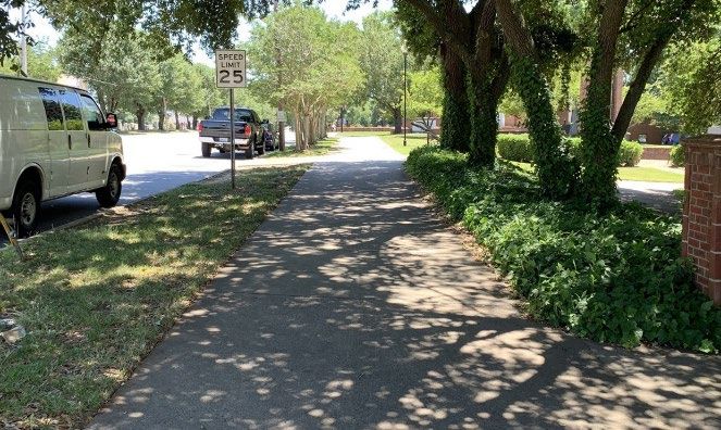
Downtown Streetscape
       Project

Conceptual Rendering from the
   Downtown Master Plan

                                4
III.   GRANT FUNDS, SOURCES, AND USES OF ALL PROJECT
           FUNDING
The Town of Boiling Springs has been the quintessential small town for decades. Recently, the Town
has seen continual growth that shows no signs of slowing down after the reopening of businesses
and the economy after COVID-19. Permitting for new homes and businesses are on the rise. In order
for Boiling Springs to have a safe, connected, and attractive place for people to live, work, and play,
these changes are necessary. Improving our existing facilities to accommodate the basic travel needs
of the community will be essential to our future success in attracting and retaining businesses and
residents. 4 We have a number of plans and projects, but the Downtown Master Plan is at the top of
the list. Unfortunately, due to the rural nature of our community, we have a smaller tax base that is
primarily dependent upon residential tax income. The 2022 RAISE Grant would have a dramatic
impact on our town.

FUNDING
The RAISE Grant would allow us to showcase the great amenities we have in a way that is inviting and
welcoming to everyone. Our yearly combined general and utility fund budget is right around $5 million.
The conceptual estimates for the Downtown Streetscape Project are over $3 million. A RAISE Grant for
$1,408,398 would completely pay for the construction of the South Main Street Streetscape project,
replace an aging water line, and transform our downtown.

The cost of project design is currently being paid for from our general fund budget. These designs
are expected to be completed before the end of the calendar year (2022). The Downtown Master
Plan contains conceptual drawings only. A detailed breakdown of the expected expenses is included
in the Appendix of this grant application.

4https://www.downtownsherman.com/economic-development/#:~:text=The%20direct
%20impact%20of%20downtown,the%20cities%20making%20those%20investments.

                                                                                                     5
Total Project Cost and RAISE request:             $1,408,398
 Streetscape Estimate:                             $1,255,437
 Water Line Replacement (under the project area)   $152,961

PROJECT TIMELINE:

                                                                   Bidding of
    Notice of Grant                   Design Completed
                                                                  construction
    Award (August                    by Boiling Springs by
                                                                 package begins
        2022)                          October 1, 2022
                                                                November 1, 2022

       Award of
                                                                   Construction
  Construction bid at                Construction to start
                                                                   complete by
  January 2023 Town                    within 6 months
                                                                December 31, 2023
    Council meeting

                                                                                    6
IV.     MERIT CRITERIA
The Downtown Streetscape Project accomplishes a multitude of improvements beyond appearance and
connectivity. They are deeply rooted in the enhancement of safety, environmental sustainability, quality
of life, economic competitiveness, and state of good repair objectives all while building upon established
partnerships in the community and greater Boiling Springs area.

The Benefit-Cost Analysis (outlined in a later section and detailed in the Appendix) indicated that the build
option has a ratio greater than 1.0, meaning that is an economically beneficial project. The table below
outlines more information. A more complete breakdown of both the project costs and benefits can be
found in Table A15 in the Appendix.

                                                                                                            7
PRIMARY SELECTION CRITERIA

SAFETY

CHALLENGES
Ensure safe intersections and driveway crossing for
people walking and biking
Downtown Boiling Spring sees thousands of students,
parents, visitors, and residents because of Gardner-
Webb and the Broad River Greenway. 5 Travelers drive
through the wide state road at speeds well over the
posted limits. Crossings, markings, and signals are
minimal or nonexistent in places. Several crashes,
fatalities, and injuries have occurred downtown over
the years. 6 AADTs in this area are expected to
decrease by 400-500 vehicles in the build scenario
outlined in Table 2 in the Benefit-Cost Analysis
section.

Currently, there are narrow sidewalks, obstructions
such as power poles in the middle of the sidewalks,
and no more than an inch or two of curb separating
vehicles from foot traffic, as shown in the picture to
the right.

Access to Clean Water
The goal of any water provider is to have accessible,
clean drinking water to all customers. A water line
that is more than 70 years old runs under S. Main,
directly in the project area. Not only is this line old
enough to need replacing, but it is also in the middle of the road. Meaning, when there is an issue,
traffic must be diverted, and the main arterial torn up and repaired. This causes issues for normal
residential travel, and it also impacts the local trucking company’s operations as they have to send
their freight trucks in another direction. The benefits derived from the build scenario for travel time
are estimated at ($581,600) for a 7 percent discount rate. This can be seen in Table A4 in the
Appendix.

SOLUTIONS

WithersRavenel is quoted as saying, “a savvy [streetscape] design avoids blind corners and accidental
hiding places, provides adequate lighting, and uses signage to clearly direct visitors. Designated bicycle
lanes and landscape buffers between road traffic and sidewalks can also increase safety.” The Downtown
Streetscape project addresses all of these issues and more which allows visitors to more easily and safely
navigate their surroundings. 7

5 https://ncdot.maps.arcgis.com/apps/webappviewer/index.html?id=964881960f0549de8c3583bf46ef5ed4
6 https://www.arcgis.com/apps/mapviewer/index.html?webmap=b4fcdc266d054a1ca075b60715f88aef
7 https://withersravenel.com/creating-pedestrian-friendly-streetscapes-benefits-people-planet-and-

                                                                                                             8
Safer Crossings Through Better Markings and Traffic Calming Measures
Signalized crossings, lighting, and signage will make safer and more visible areas for pedestrians to
traverse Main Street. Curb extensions will create shorter crossing distances and better visibility for
pedestrians. These extensions or bulb-outs will also create a physical and visually narrower lane for
vehicular traffic. "Curb extensions improve safety because they increase visibility, reduce speed of
turning vehicles, encourage pedestrians to cross at designated locations, shorten the crossing
distance, and prevent vehicles from parking at corners." 8
Creating a Safe and Inviting Space
"Wider sidewalks should be installed near schools, at transit stops, in downtown areas, or anywhere
high concentrations of pedestrians exist."6 Main Street improvements will reduce traveling lane
widths from an average of 17-feet to 11-foot lanes, reduce the parking lanes from 9 feet to 8 feet,
and include a new 12-foot multi-use trail with a 7-foot greenspace.
Accessible Utilities
Replacing and moving an existing water line will not only make repairs more convenient, but it will also
allow the flow of traffic to freely continue and not be stopped or diverted. Protecting these utility lines for
maintenance and repair is essential to the physical integrity of the distribution system. 9
ENVIRONMENTAL SUSTAINABILITY
CHALLENGES
Limited and Congested Parking Along Main Street
As development has occurred in downtown Boiling Springs, it has been allowed to happen organically
without regulation. This has resulted in areas that are hard to navigate and do not complement the
surrounding areas or amenities. This leads to confusion, traffic, and endangers pedestrians. All of this
occurs on a state-maintained road that is also Main Street.
SOLUTIONS
Improved and Additional Parking
By adding additional and improving existing parking, the downtown area will have less congestion,
increase the desire and ability of travelers to visit our downtown, and allow users the opportunity
to park and explore our downtown on foot which creates less pollution from fewer cars driving from
point-to-point. “Studies show people who walk or bike to an area generally return more often and
spend more time and money in the area.” 10 The benefits derived from the build scenario for travel
time are estimated at ($581,600) for a 7 percent discount rate. This can be seen in Table A4 in the
Appendix.
A More Environmentally Friendly Way to Travel
The Gaston-Cleveland-Lincoln Metropolitan Planning Organization's Metropolitan Transportation
profitability/#:~:text=A%20savvy%20design%20avoids%20blind,sidewalks%20can%20also%20increase
%20safety.
8 http://pedbikesafe.org
9 https://nap.nationalacademies.org/read/11728/chapter/3#39
10 https://www.wglt.org/show/wglts-sound-ideas/2017-04-17/downtown-areas-can-be-a-model-for-
economic-development#stream/0
9Plan emphasizes efficient transportation systems and has the goal of increasing the quality of life in
the region. 11 A path for residents to get out of their car and get outdoors would accomplish these
goals and more. The MTP also aims to provide equitable transportation options and provide the
public with more transportation sources; the Downtown Streetscape Project satisfies both.
The EPA’s literature on Smart Growth and Transportation states that, “Transportation facilities and
networks have the power to shape development, influence property values, and determine a
neighborhood's character and quality of life. In addition, transportation investments have
important consequences for the environment, including air and water quality, climate change, and
open space preservation. How communities develop also affects how convenient and appealing
public transportation, bicycling, and walking are for their residents.” 12 We foresee all of these
positive changes occurring in downtown Boiling Springs. The benefits derived from the build
scenario for vehicle emissions are estimated at ($137,000) for a 7 percent discount rate. This can be
seen in Table A6 and A8 in the Appendix.
QUALITY OF LIFE
CHALLENGES
Regional Traffic Impact
NC-150 serves as a regional connection to a wide area of the state. It also serves as Main Street for
several communities throughout its span. Traffic on these types of roads can negatively impact the
quality of life through increased emissions, congestion, dangerous vehicular traffic, crashes, and
pedestrian fatalities. The benefits derived from the build scenario for vehicle emissions are
estimated at ($137,000) for a 7 percent discount rate. This can be seen in Table A6 and A8 in the
Appendix. Additionally, the Crash Modifications Factors for each improvement type are shown in
the table below and are further outlined in the Benefit-Cost Analysis section and the Appendix.
Turner Trucking is a large business and central economic driver to Boiling Springs. They are a national
trucking company located in our downtown. Their trucks travel this corridor and deliver goods from coast
to coast. Their employees are based locally, and their business is impacted by the unaccommodating
layout of our current street and sidewalk network. Trucks can consistently be seen mounting curbs and
sidewalks and rubbing against power poles that are located too close to the roadway. Currently, almost all
of the poles in the project area do not meet the US DOT FHA standards for urban tree and utility pole
11 https://gclmpo.org/plans-programs-and-studies/long-range-planning/
12 https://www.epa.gov/smartgrowth/smart-growth-and-transportation
10practices. 13 The benefits derived from the build scenario for travel time are estimated at ($581,600)
for a 7 percent discount rate. This can be seen in Table A4 in the Appendix.
Access to Opportunity
Average Annual Daily Traffic in 2019 was 9,600 for Main Street / NC-150.14 This is an area that people
rush through on their way to their destination. For those that do stop, they risk being another
statistic on this hazardous roadway.17 The Benefit-Cost Analysis section shows how this number
decreases dramatically through the build scenario.
SOLUTIONS
Multimodal Small Town
“Street design determines whether an area will be safe and inviting for pedestrians, bicyclists, and
transit users, which affects the viability of certain types of retail, influences land values, and tax receipts,
and shapes overall economic strength and resilience.” 15 The MTP aims to provide a safe, comprehensive,
and efficient transportation system that allows the movement of people through each jurisdiction within
its region. 16 The Downtown Streetscape Project allows for a safer commute, a more pedestrian-friendly
space, and a connected town extending from our downtown outward.
Connectivity that Breaks Down Barriers
The Downtown Streetscape Project redefines the hub of our community and connects more areas
that not all residents currently have access to such as banks and grocery stores. As a community
contemplates its future and the changes in population and uses, it must consider how the people
that currently live in the area and those that move to the area will rely on alternative modes of
transportation. Not everyone has access to a motor vehicle and not every trip from a persons home
to a local business should be dependent on this singular mode of transportation. 17
Public Health Benefit
Improved public health is another benefit of the proposed project. 18 The project will make Main
Street and the community of Boiling Springs more pedestrian and bicycle friendly through the
following improvements:
• Reduced crossing width of Main Street
• Wider sidewalks
• Wider boulevard between pedestrians and vehicles ADA compliant facilities Intersection
bump outs
IMPROVES MOBILITY AND COMMUNITY CONNECTIVITY
CHALLENGES
Disconnected Downtowns Lead to Haphazard Movements
The current state of downtown Boiling Springs sees sidewalks on one side of the street in certain areas
13https://safety.fhwa.dot.gov/roadway_dept/countermeasures/safe_recovery/clear_zones/fhwasa16043/ch
4.cfm#:~:text=Utility%20poles%20and%20trees%20of,4%20feet%20behind%20the%20curb.
14https://ncdot.maps.arcgis.com/apps/webappviewer/index.html?id=964881960f0549de8c3583bf46ef5ed4
15 https://www.epa.gov/smartgrowth/smart-growth-and-transportation
16 https://gclmpo.org/plans-programs-and-studies/long-range-planning/
17 http://hcggis.harfordcountymd.gov/Planning/NEXT/pdf/Chapter6.pdf
18 https://mobilitylab.org/2015/07/09/streets-and-sidewalks-should-be-used-to-improve-our-health/
11that continue on another side of the street as you move further along. Some even stop short of frequently
used amenities, such as the local grocery store. This leads pedestrians to cross at dangerous areas and
inopportune moments which can lead to fatalities; one of which occurred within the project area a few
short years ago. 19 Crash Modification Factors are listed below, outlined further in the Benefit-Cost Analysis
section and detailed in the Appendix.
Pedestrian (Install High-Visibility Crosswalk) (CMF ID: 4123)
o Shows improvements for all crashes at both signalized and unsignalized intersections.
CMF = 0.60
Pedestrian (Install Raised Median with Marked Crosswalk - Uncontrolled) (CMF ID: 175)
o Shows improvements for all crashes.
CMF = 0.54
Improve Signal Head Visibility (CMF ID: 1430)
o Install highly visible backplates to the signal heads
CMF = 0.93
Modify Signal Phasing (Implement a Leading Pedestrian Interval) (CMF ID: 1993)
o Highly effective at intersections with more than 300 pedestrians a day
CMF = 0.413
Changing Left-Turn Phasing from Protected-Permissive to Flashing Yellow Arrow (CMF ID: 9668)
o Flashing Yellow Arrow has been shown to be more effective than a green ball
CMF = 0.86
Pedestrian Movement is Impeded
With power and communication poles in the middle of sidewalks, the 4-foot-wide paths create little room
for being pinned against a building or stepping into the street. With an active community, business district,
and global university residing in our downtown core, the feeling of congestion and claustrophobia quickly
sets in. As mentioned previously, the offset of utility poles from sidewalks is not currently adhered to. This
limits visibility, inhibits maintenance of the pedestrian facilities, and decreases safety. 20
SOLUTIONS
Improve and Add Crosswalk and More Sidewalks
The Downtown Streetscape Project adds needed crossings, bump outs for pedestrians to be more visible,
and extends sidewalks to areas not currently served. We want visitors to feel safe and welcome when they
visit downtown. Clark Nexsen says, “well-designed streetscapes provide a wealth of benefits for their
respective communities. In more recent years, we have seen a synergistic shift toward design strategies
that activate the surrounding area and create a sense of place for citizens.” 21
ECONOMIC COMPETITIVENESS AND OPPORTUNITY
CHALLENGES
Attracting and Retaining Talent
19 https://www.ncdot.gov/bikeped/walkbikenc/safety_post/state-crash-map/default.aspx
20https://safety.fhwa.dot.gov/roadway_dept/countermeasures/safe_recovery/clear_zones/fhwasa16043/ch
4.cfm#:~:text=Utility%20poles%20and%20trees%20of,4%20feet%20behind%20the%20curb.
21 https://www.clarknexsen.com/blog-best-practices-for-streetscape-design-that-cultivates-community/
12Gardner-Webb University is the focal point of the downtown in Boiling Springs. No one notices our
downtown streetscape because there is nothing to look at. Potential employees of GWU want to
look outward and see an inviting community when deciding on their future place of employment.
New businesses want to see a safe, efficient, and vibrant downtown. Currently, we are lacking in
these areas.22
SOLUTIONS
Connecting Our Community
The Downtown Streetscape Project establishes a multi-modal solution to the connectivity issues we
currently face while revitalizing an area that has been stagnant for decades. “Revitalization is
important to cities and towns across the country. Restoring downtown communities can increase a
municipality’s economy and boost the sense of pride citizens have in their community.” 23 By
making our community more accessible overall, we can achieve this type of support and
subsequent growth.
Recruitment and Retention
By improving our transportation network, we bring the type of people and businesses to our area
that give us a competitive edge for the right talent. 24 “The property owners are a vital asset
[downtown], even though they may not…see themselves – as that…Each community should develop
ways to support, energize, and expand those businesses to fill vacant storefronts downtown – or
nearby – and position the community for future investment.” 25
STATE OF GOOD REPAIR
CHALLENGES
Maintaining a Reliable Transportation Network
South Main Street in Boiling Springs is currently rated in "good" condition by the NC DOT. However, the
other 'half' of Main Street to the north is rated fair. It is only a matter of time before the traffic that
travels on both sections of this roadway wears it down and decreases its safety and efficiency.
SOLUTIONS
Preparing for the Future
The Downtown Streetscape Project addresses congestion and lessens vehicular travel which
increases the lifecycle of roadways. The benefits derived from the build scenario for travel time are
estimated at ($581,600) for a 7 percent discount rate. This can be seen in Table A4 in the
Appendix. The Town of Boiling Springs is committed to the Downtown Streetscape Project and has
shown this through its initial investment in planning and design. Furthermore, the Town is
committed to the maintenance of the Downtown Streetscape Project to ensure that it stays in a
state of good repair. 26 Our Public Works and Recreation Department already maintain similar
facilities (parks, roadways, etc.) and these additions will fit into their current responsibilities.
Property Value Increase
22 https://jgscgroup.com/case-study-projects/downtown-revitalization/
23 https://uca.edu/cced/files/2020/03/City-Town-July-2019-Vol.-75-No.-07.pdf
24 https://homegrowntools.unc.edu/index.php/strategy/downtown-revitalization/
25 https://www.nlc.org/article/2021/07/26/how-to-create-business-growth-in-a-small-citys-downtown/
26 https://highways.dot.gov/public-roads/julyaugust-2004/life-cycle-continuum
13Main Street passes through the downtown business district. The southern portion of the project
serves as State Highway 150 and provides connectivity between adjacent residential
neighborhoods. Many of the immediately surrounding residential neighborhoods are distressed
and are below the low/moderate income threshold established by HUD. Many residents rely on the
corridor for travel to employment, health care and other daily essential services. The proposed
project improvements will support the transportation needs of development through the
pedestrian, and multi-modal improvements along the corridor. As a result of the proposed project
improvements, it is expected that redevelopment will occur along the project corridor and that
property values will increase because of the project. 27
PARTNERSHIP AND COLLABORATION
This grant brings together an entire community of partners. The Downtown Streetscape Project
was born from the Downtown Master Plan that the Town of Boiling Springs adopted in late 2020.
This was the culmination of almost a year-long process of community and regional input. It involved
feedback from residents and allowed multiple levels of stakeholders to have a voice in the process.
The Downtown Streetscape Project borders Gardner-Webb University and will affect their students and
staff. This partnership is vital to the continued growth and development of our town. ‘Both sides of
the street’ are supportive of the Downtown Streetscape Project application, as shown in the letters
of support included in the Appendix. With Main Street being a state- maintained road, a partnership
with NC DOT will be crucial. We are familiar with their staff and have worked with them on developing
the Downtown Streetscape Project.
In a small community, regional planning is extremely important and not something we can do on
our own. That is why the Gaston- Cleveland-Lincoln Metropolitan Planning Organization is a key
partner in ensuring past and future transportation additions and improvements work for our town
and make the region a more established and robust network for all its users. Their support is shown
through the letter included in the Appendix.
INNOVATION
Theodore Levitt said, “Creativity is thinking up new things. Innovation is doing new things.” The
culmination of the Downtown Master Plan that spurred the Downtown Streetscape Project was the
creative part. Now, Boiling Springs has reached the innovative part of making a vibrant streetscape a
reality. With the assistance of DOT and the RAISE grant, we can create a place that people enjoy being in
and utilize more. This benefits the community, the businesses, the university, and the greater Boiling
Springs area with increased visitors. Making sure these changes are done deliberately and in a responsible
manner, will ensure we maintain balanced growth. 28
Innovative Technologies
The changing of the downtown streetscape will allow us to reimagine the current assets we have
and will allow us the opportunity to change these for the better. Currently, pedestrians cross
between parked cars with low visibility. If they do choose to cross at one of the two cross walks,
there is little to no signage. The addition of three new crosswalks and the up fitting of the two
27 https://turffactorydirect.com/2020/10/02/how-new-development-affects-home-value/
28 https://www.oecd-ilibrary.org/sites/82b46508-en/index.html?itemId=/content/component/82b46508-en
14existing will improve visibility, safety, and awareness of pedestrians in the area. 29 It will also help
slow traffic in an area that currently has wide lanes and speeding issues. 30
Adding hi-visibility signs, painted bars on the road, curb bulbs, and flashing lighted signs will take
our pedestrians crossing and their level of safety to a much higher standard. With increased visitors
to downtown utilizing the wider sidewalk, steady residential and business growth in the town, and
the university’s continued expansion, these technologies will be key to making visitors feel safe and
the space feel inviting.15
Innovative Project Delivery
A huge streetscape project in the center of downtown will disrupt the flow of traffic, business
accessibility, and have an impact on parking. To allow businesses to continue to operate and
visitors to still utilize the amenities there, we will partner with local businesses and the university to
offer more parking options to visitors downtown. We can reroute traffic around downtown and
keep travelers on their way to their destination. Parking is already a concern, one that will be
addressed with the implementation of the Downtown Streetscape Project, so ensuring that the
concern is minimized during construction will keep all parties satisfied and the impacts to traffic to
a minimum.
Innovative Financing
With the implementation of the American Rescue Plan Act, we have been able to utilize funds we
would not otherwise have access to. This has allowed us to move forward with design and bid
preparation with the consulting firm McGill and Associates without the use of grants or other
funding. Since we are a small community with a small budget, we have done as much as we can to
move this project forward. Without the assistance of the DOT RAISE grant, we will not be able to
make this project a reality. We will have plans and designs finalized in the coming months (fall of
2022) so that we are able to move swiftly once awarded the RAISE grant, but without funds for
construction, this project will only live on paper.
29http://guide.saferoutesinfo.org/engineering/traffic_signals.cfm#:~:text=At%20signalized%20intersections
%2C%20Leading%20Pedestrian,will%20see%20them%20while%20turning.
30 https://safety.fhwa.dot.gov/ped_bike/univcourse/pdf/swless15.pdf
15V. PROJECT READINESS: ENVIRONMENTAL RISK
The collaborators on this project have long-standing partnerships that span decades. These effective
working relationships combined with the community's backing of the Downtown Master Plan is an
ideal situation that lends itself to a speedy completion.
PROJECT SCHEDULE
After receiving the RAISE Grant Obligation notice, some elements of the project will be ready to
begin construction or implementation almost immediately. Preliminary design, done by McGill &
Associates, is expected to be complete by fall of 2022. The RAISE grant application is for the
construction of these projects. The Town has begun preliminary design based off our existing
conceptual plan. It is anticipated that construction will be ready to commence in the spring of 2023,
after bidding occurs late 2022.
PROJECT RISKS AND MITIGATION STRATEGIES
RISK: Project Partners are unfamiliar with RAISE Grant implementation and protocols
MITIGATION: Several of our partners (McGill & Associates, Gardner-Webb, NC DOT, GCLMPO) are
familiar with federal grants and willing to assist by consulting in any area needed. Also, the
selection process for a project contractor will ensure that the firm selected has the capacity to
report and implement as required.
RISK: Maintenance of these expanded facilities over time
MITIGATION: The Town has a Public Works Department with 10 full-time employees who handle
duties from paving repair to landscaping. Some of these employees also oversee critical
16infrastructure so they have a diverse skillset regardless of what needs may occur.
REQUIRED APPROVALS
STATE AND LOCAL
Letters of support have been provided in the submitted documents from elected officials, the
GCLMPO, and project partners for the Downtown Streetscape Project.
NC DOT
The Town has met with NC DOT and informed them of the RAISE application for these projects. DOT
was also involved in the Downtown Master Plan process from which the Downtown Streetscape
Project was derived.
The experience of the groups involved and the commitment by such a diverse array of individuals or
groups already proves the success of the Downtown Streetscape Project.
There is also a limited number of organizations involved and being able to accomplish a project with
fewer moving parts also ensures its success.
VI. BENEFIT COST ANALYSIS
The Downtown Streetscape Project encompasses a stretch of undivided highway in the heart
Boiling Springs and on the eastern edge of Gardner-Webb University. It is a 2-lane section,
0.6 miles long and includes 8 intersections. Majority of the two-lane section has on-street parking,
a 19-foot-wide southbound travel-lane and a 15-foot northbound travel-lane. There is one
signalized intersection of East College Avenue which is also the main east-west corridor through
town. North and south of the signalized intersection, the intersections of E Branch Avenue, Falcon
Circle, Decker Court, Quinn Circle, Hamrick Avenue, Woodland Avenue, Green/Bethel Avenue, and
Holland Drive have higher pedestrian use or are planned for future development and were thus
included in a corridor study.
To mitigate risks associated with the two-lane section, a reduction of lane width to 11 feet is
proposed and would incorporate additional on-street parking with permeable pavement, 12-foot
multi-use path, 7 feet of additional greenspace for reduction of impervious pavement, multiple
highly visible pedestrian crossings with bump outs to reduce crossing width, improvement to the
signal with improved signal timing, improved pedestrian facilities. This stretch of roadway is a key
corridor for pedestrians during in the week and provides the primary state highway route from
south to west in Boiling Springs.
Development opportunities exist in nearby residential neighborhoods, but more specifically,
housing inventory along Hamrick Avenue and Woodland Avenue could redevelop into a multi-
family or attached housing typology to increase density and increase housing availability.
For the study, a build alternative was analyzed and compared to a no-build alternative. The
alternatives are listed below:
1.No-Build – Do nothing alternative
172.Build - Construct improved two- lane section of Main Street from E Branch Avenue to Holland
Drive consisting of a reduction of lane width to 11 feet is proposed and would incorporate
additional on- street parking with permeable pavement, 12-foot multi-use path, 7 feet of additional
greenspace for reduction of impervious pavement, multiple highly visible pedestrian crossings with
bump outs to reduce crossing width, improvement to the signal with improved signal timing,
improved pedestrian facilities. Also
BACKGROUND INFORMATION
A primary goal for this project is to improve safety and provide multimodal transportation
opportunities while maintaining traffic flow at an acceptable level of service. Using North Carolina
Department of Transportation (NCDOT) crash data from 2011-2020, showed that there were 15
crashes along the corridor. In all, there was one fatality, and two suspected serious injury crashes
associated with this stretch of roadway in the 10-year time. Table 1 shows a summary of collisions
along this stretch.
Providing alternative modes of transportation is another priority in undertaking this project. Boiling
Springs has higher than average pedestrian traffic for a community its size due to the Gardner-
Webb University. There are currently multiple pedestrian crossings along the corridor that are not
highly visible due to the on-street parking.
With the changes being made to improve pedestrian facilities along Main Street there may be an
increase in other forms of transportation such as biking and walking. See Table 2 for a summary of
expected AADTs for build and no-build conditions. These volumes include a 0.5% annual increase in
traffic and the reduction of vehicular use.
The purpose of a benefit-cost analysis is to express the effects of an initial investment into a
common measure, base-year dollars. This accounts for benefits occurring over long periods of time,
while most of the costs are incurred as an initial investment. Under this approach, a project with
monetized benefits that are greater than its costs will have a benefit-to- cost ratio greater than one
and therefore is considered an economically beneficial endeavor.
BENEFIT-COST METHODOLOGY
The monetary benefit for this project is quantified in terms of either a reduction or increase in
vehicle miles traveled (VMT), vehicle hours traveled (VHT), project area collisions, vehicle emissions,
and roadway maintenance. The costs considered for the project include surfacing, subbase/base,
grading and drainage, signal and lighting construction, right-of-way acquisition, as well as
engineering and design fees. The itemized cost breakdown of the build scenario is shown in Table A2
of the Appendix. Remaining capital values of these roadway features at the end of the analysis
18period are subtracted from the total cost of the project. The salvage values can be found in Table A3
of the Appendix for a 7 percent discount rate.
The results of the analysis provide input for evaluating the overall benefit of the proposed
improvements to the area. Since the current design is still preliminary, it should be noted that
certain benefits and costs may change prior to final design, however these changes are anticipated
to be relatively minor as initial cost estimates were made to be conservative.
• All monetary values are discounted to the 2019 analysis year.
• The 20-year benefit period is based on a 2024 day-of-opening through the year 2043.
Benefits are assumed to start July 1st, 2024 and end December 31st, 2043.
• Yearly Build and No-Build benefits are calculated based on linear interpolation over the 20-
year analysis period.
• Longer travel times and rerouting of trips during construction years are not included in this
analysis. Construction is anticipated to occur under traffic.
• Preliminary cost estimates were completed using unit costs for grading, base, and pavement.
An appropriate risk factor given the early stage in the project development process was
therefore used.
• 260 days per year was used in the analysis of weekday VHT, VMT, and emissions.
• Weekend VHT, VMT, and emissions were considered as well. A proportion of weekday VHT,
VMT, and emissions benefits were applied to 105 weekend days per year. This process used a
fraction of traffic for Saturdays and Sundays versus an average of Tuesday, Wednesday, and
Thursday traffic to allocate weekend benefits since weekend traffic was not modeled as part of
the traffic analysis.
• General assumptions regarding the costs associated with project area collisions, vehicle
operating costs, time costs, component service life, analysis period, and discount rates can
be found in Table A1 of the Appendix.
TRAFFIC ANALYSIS
Traffic forecasts were determined under both no-build and build scenarios. The forecasts were
determined based on historical Annual Average Daily Traffic (AADT) counts available from the
NCDOT, current year traffic count data collected in 2019. The AADT data along with historical AADT
data was used to determine growth rates on Main Street through the corridor. It was noted that
volumes have fluctuated positively and negatively in recent years, so a 0.5% annual growth was
assumed.
No Build
For the No Build forecast, the growth rate along Main Street was 0.5 percent per year based on the
AADT’s.
Build
The Build scenario keeps the traffic flow the same, therefore the forecast the growth rate along
Main Street is also 0.5 percent per year based on the AADT’s.
Analysis
Synchro/SimTraffic was used to analyze the various traffic scenarios and configurations. The values
obtained using the modeling software provide travel distance (vehicle miles traveled - VMT) and travel
19time (vehicle-hours traveled - VHT) for the corridor. See Table 3 for VMT and VHT during 2024 and 2043
build and no- build scenarios.
CALCULATION OF BENEFITS
Economic values for VHT, VMT, and emissions were obtained from the US Department of
Transportation (USDOT) guidance: “Benefit Cost Analysis Guidance for Discretionary Grant
Programs (2021)”. See Table 4 for a summary of economic values that were used for this analysis. A
20- year analysis period beginning in 2023 and ending in 2042 was chosen for the benefit-cost
evaluation with all values discounted to 2019 dollars.
TRAVEL TIME BENEFITS
Delay benefit was calculated in terms of delay per person. Using USDOT’s guidance of 1.67 persons
per car and 1.0 persons per truck, delay was calculated by using these multipliers and the travel time
reported in vehicle hours by SimTraffic. The economic costs of this delay were then quantified by
using USDOT’s suggested values for auto and truck travel time savings. The benefits derived from
the build scenario for travel time are estimated at ($409,000) for a 7 percent discount rate. 2024
and 2043 delay benefits can be seen in Table A4 of the Appendix and a yearly breakdown of the
benefit-cost analysis pertaining to delay can be found in Table A5 of the Appendix.
VEHICLE OPERATIONS AND EMISSIONS BENEFITS
Vehicle operations and emissions benefit were determined by using USDOT’s suggested values
based on a cost per mile traveled. The benefits derived from the build scenario for vehicle
operations are estimated at $985,000 for a 7 percent discount rate. The benefits derived from the
build scenario for vehicle emissions are estimated at $137,000 for a 7 percent discount rate. 2024
and 2043 delay benefits can be seen in Table A6 and Table A8 of the Appendix. A yearly breakdown
of the benefit-cost analysis pertaining to vehicle operation and emissions can be found in Table A7
and Table A9 of the Appendix.
OPERATION AND MAINTENANCE BENEFITS
Roadway and utilities maintenance along Main Street would not be needed if the project does not
happen, as NCDOT just performed maintenance on the corridor in 2020. The maintenance is expected to
occur with the project year for build conditions was estimated for 2024.
SAFETY BENEFITS
The methodology used to complete the crash analysis and corresponding benefit-cost ratio is described
in the following paragraphs. Crash reduction within the project area was determined by separating
intersections and segments so that factors and state averages could be applied appropriately. Crashes
were obtained from the NCDOT Crash database for a ten-year period from 2011-2020. These collisions
were then annualized and reductions and additions of crashes were added appropriately relative to
geometry reconfigurations.
Main Street will reduce traveling lane widths from average of 17-feet wide to 11-foot lanes, reduce the
parking lanes from 9 feet to 8 feet, and include a new 12-foot multi-use trail with a 7 foot greenspace.
The current and projected traffic volumes allow the conversion with limited other improvements
required. The following are improvements at intersections based on the traffic study:
20• At the signalized intersection, the signal heads will be made highly visible with highlighted
backplates, updated timings and pedestrian crossings timings, introduction of flashing yellow
left-turn for the protected permitted left-turns.
• Installation of high-visibility crosswalks will be installed near the intersections of E Branch
Avenue and Decker Court.
• Installation of a raised median refuge for the crosswalk near Holland Drive.
Crash modification factors were reviewed from the Highway Safety Manual (HSM) and the Crash
Modification Factors (CMFs) Clearinghouse. Crash modification factors were used to determine the
anticipated number of crashes after an improvement is made to an intersection or roadway. The Crash
Modification Factors (CMF) for each improvement type are outlined on the below.
• Pedestrian (Install High-Visibility Crosswalk) (CMF ID: 4123)
o Shows improvements for all crashes at both signalized and unsignalized intersections.
CMF = 0.60
• Pedestrian (Install Raised Median with Marked Crosswalk - Uncontrolled) (CMF ID: 175)
o Shows improvements for all crashes.
CMF = 0.54
• Improve Signal Head Visibility (CMF ID: 1430)
o Install highly visible backplates to the signal heads CMF = 0.93
• Modify Signal Phasing (Implement a Leading Pedestrian Interval) (CMF ID: 1993) Highly effective
at intersections with more than 300 pedestrians a day
o CMF = 0.413
• Changing Left-Turn Phasing from Protected-Permissive to Flashing Yellow Arrow (CMF ID: 9668)
• Flashing Yellow Arrow has been shown to be more effective than a green ball CMF = 0.86
A copy of the CMFs are included in the Appendix. After establishing no-build and build crashes for 2020
using the CMFs, forecasted 2024 and 2043 collisions were obtained by inflating numbers according to
the expected AADT growth along Main Street for the no- build and build scenarios.
The USDOT’s value of a statistical life (VSL) provided in the Benefit-Cost Analysis Guidance for
Discretionary Grant Programs were used for the values of the crashes. A resulting benefit of $5,302,000
was obtained for a 7 percent discount rate over the 20- year analysis period. A yearly breakdown of the
benefit-cost analysis pertaining to this decrease in collisions can be seen in Table A12 of the Appendix.
PROPERTY VALUE INCREASE
Main Street passes through the downtown business district. The southern portion of the project
serves as State Highway 150 and provides connectivity between adjacent residential
neighborhoods. Many of the immediately surrounding residential neighborhoods are distressed
and are below the low/moderate income threshold established by HUD. Many residents rely on the
corridor for travel to employment, health care and other daily essential services. The proposed
project improvements will support the transportation needs of development through the
pedestrian, and multi-modal improvements along the corridor. As a result of the proposed project
improvements, it is expected that redevelopment will occur along the project corridor and that
property values will increase as a result of the project.
We have estimated the property value increase through the review of available properties and
21proposed zoning. The property value information was analyzed using the existing valuation of the
parcels in the corridor, according to the Cleveland County Assessor information.
As identified in the Boiling Springs Downtown Master plan in September 2020, new mixed-use
residential developments are proposed to the east of Main Street along Woodland Avenue. The
Main Street project will act as a catalyst for the development. The estimated new value of these
sites was determined by estimating the square foot of each type of new land use development
identified in the concept plan and then assigning a value per square foot for each type of use. The
value of the land was not adjusted, only the value of structures and/or dwellings as appropriate.
The net total change was determined by the estimated value following redevelopment within the
corridor.
This project which could be phased over the 20-year life of the project is estimated to be valued at
$2,285,000 and contributes a positive net change to the overall corridor valuation by
$1,752,000.
Based on the positive net change anticipated, the estimated benefit along the corridor totals
$1,752,000 in the 20 years following construction. The total discounted property value increase
benefits are $973,000 at a 7 percent rate. A yearly breakdown of the benefit-cost analysis pertaining
to Property Value can be found in Table A13 of the Appendix.
Public Health Benefit
Improved public health is another benefit of the proposed project. This benefit was not quantified,
but the improved pedestrian and bicycle facilities will improve public health. The project will make
Main Street and the community of Boiling Springs more pedestrian and bicycle friendly through the
following improvements:
Reduced crossing width of Main Street Wider sidewalks
Wider boulevard between pedestrians and vehicles ADA compliant facilities
Intersection bump outs which will reduce vehicle speed, reduce the pedestrian crossing
distance, and improve pedestrian visibility to vehicles
New multi-use trail connecting a highly used community facility
Stormwater Runoff Mitigation
The project will also improve stormwater runoff management through less vehicle travel lanes, tree
plantings, permeable widened boulevard space, and other green street elements where practical to
reduce stormwater runoff and improve water quality.
BENEFIT COST ANALYSIS RESULTS
Table A14 of the Appendix shows a yearly breakdown of design and construction costs for the
project. See Table 6 for a results summary of the benefit-cost analysis for the Main Street
Improvement Project.
The analysis indicates that the build option has a benefit-cost ratio greater than 1.0, meaning that it
is an economically beneficial project. The benefits of the project are estimated to be higher than the
costs associated with the construction of the project.
22In addition, we believe that the estimated property value increase over the analysis period is
conservative. A more complete breakdown of both the project costs and benefits can be found in
Table A15 of the Appendix.
ADDITIONAL RESOURCES
“Benefit-Cost Analysis Guidance for Discretionary Grant Programs.” Office of the Secretary. U.S.
Department of Transportation, https://www.transportation.gov/sites/dot.gov/files/2021-
02/Benefit%20Cost%20Analysis%20Guidance%202021.pdf
“Highway Safety Manual” Washington D.C. American Association of State Highway and Transportation
Officials. 2010. Book
“Crash Modification Factors Clearinghouse.” Safety Research Center, U.S. Department of Transportation
Federal Highway Administration, http://www.cmfclearinghouse.org/
23You can also read