Cork County Development Plan Review - Cork County Council
←
→
Page content transcription
If your browser does not render page correctly, please read the page content below

Scoping
                                                Report
                                                 2019

          Cork County Development Plan Review

          Strategic Environmental
          Assessment
          Scoping Report for the Cork
          County Development Plan 2021-
          2027
          Background Document No. 11

Planning Policy Unit
Cork County Council
Scoping
Report
 2019

      Table of Contents

      1.0        Introduction and Context............................................................................................................ 1
      2.0        Background to the Cork County Development Plan (CDP) ......................................................... 1
      3.0        Legislative Background and stages of SEA and the Plan process................................................ 2
      4.0        SEA Guidance, Methodology and the integration of other assessments ................................... 5
          4.1 Habitats Directive Assessment (HDA) ........................................................................................ 6
          4.2 Strategic Flood Risk Assessment ................................................................................................ 7
          4.3 Climate Change .......................................................................................................................... 7
      5.0        Relationship with other plans and programmes ........................................................................ 8
      6.0        Baseline gathering..................................................................................................................... 10
          6.1 Environmental Sensitivity Mapping (ESM)............................................................................... 12
          6.2 Biodiversity – Flora and Fauna ................................................................................................. 14
             6.2.1 Links between Biodiversity, Climate Change and Flooding ................................................. 19
          6.3 Population and Human Health ................................................................................................. 21
          6.4 Soils & Geology ........................................................................................................................ 26
          6.5 Water ....................................................................................................................................... 29
          6.6 Air and Climatic Factors ........................................................................................................... 33
          6.7 Material Assets & Infrastructure.............................................................................................. 35
          6.8 Architectural, Archaeological and Cultural, Heritage .............................................................. 36
          6.9 Landscape................................................................................................................................. 37
      7.0        Scoping of SEA Topics ............................................................................................................... 40
      8.0        Proposed Framework for Assessing Environmental Effects ..................................................... 44
      9.0        Alternatives ............................................................................................................................... 47
      10.0       Statutory Consultation Process................................................................................................. 48
          10.1 Notice to Environmental Authorities ...................................................................................... 48
      11.0       Outcome of the Scoping Exercise and next steps ..................................................................... 48

                                                                                 0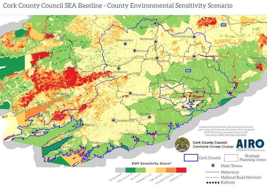
Scoping
                                                                                                                     Report
                                                                                                                      2019
1.0        Introduction and Context

Cork County Council intends to review the Cork County Development Plan 2014-2020 and prepare
the new Cork County Development Plan 2021-2027 under Sections 11 and 12 of the Planning and
Development Act 2000 (as amended).

This Scoping Document forms part of the official Strategic Environmental Assessment (SEA) process
under S.I. 436 of 2004 1 as amended by S.I. 201 of 2011 2. The purpose of this document is to provide
preliminary information on the proposed County Development Plan, with a view to establishing the
scope, level of detail and approach required for the SEA which will follow. It is intended that the
information contained within the report will enable meaningful consultation with statutory and non-
statutory consultees in relation to the proposed County Development Plan.

The process is currently at a stage where this Draft SEA Scoping Report (which will be updated to
take account of submissions made by environmental authorities) has been prepared.

In parallel to the SEA Scoping, Cork County Council are also presenting for consultation a Public
Consultation Document which will outline the scope of issues to be addressed during the review
process. Further information on the Public Consultation Document can be found at
https://www.corkcoco.ie/en/Cork-County-Development-Plan-2021-2027

2.0        Background to the Cork County Development Plan (CDP)

The Cork County Development Plan is part of a systematic hierarchy of land use plans and spatial
plans which fall under the National Planning Framework (NPF) – Project 2040 and the Draft Regional
Spatial and Economic Strategy (RSES). These plans contain higher level policy and objectives which
will in turn steer the development of Cork County at a lower level and it will be necessary to show
evidence of adherence to these plans as part of the CDP.

In accordance with Section 11 of the Planning and Development Act, 2000 (as amended) a planning
authority is legally obliged to prepare a Development Plan (CDP) for its functional area every six
years. However Section 11(AB) of same Act states that ‘the council of the county of Cork shall, not
later than 4 years (or such longer period, not exceeding 5 years, as the Minister may specify by order)
after the making of a development plan, give notice of its intention to review its existing
development plan and to prepare a new development plan for its area’. Therefore the review process
for the Draft County Development Plan 2021 – 2027 shall commence on 6th December 2019 with
the publication of the Public Consultation Document along with 11 background documents including
the SEA Scoping Report. The other background documents cover the following topics:

1.     Approach to County Development Plan Review
2.     Population & Housing
3.     Rural Housing
4.     Settlements and Placemaking

1
    S.I. No. 436/2004 - Planning and Development (Strategic Environmental Assessment) Regulations 2004
2
    S.I. No. 201/2011 - Planning and Development (Strategic Environmental Assessment) (Amendment) Regulations 2011

                                                            1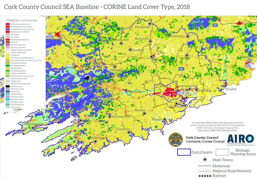
Scoping
                                                                                                    Report
                                                                                                     2019
5.    Urban Capacity Study
6.    Economy and Employment
7.    Water Services
8.    Transport and Mobility
9.    Energy
10.   Built Heritage

3.0      Legislative Background and stages of SEA and the Plan process

Strategic Environmental Assessment is a process for evaluating, at the earliest appropriate stage, the
environmental consequences of implementing plan/ programme initiatives prepared by authorities
at a national, regional or local level or which are prepared by an authority for adoption through
legislative means. The purpose is to ensure that the environmental consequences of plans and
programmes are assessed both during their preparation and prior to adoption. The SEA process also
gives interested parties an opportunity to comment on the environmental impacts of the proposed
plan or programme and to be kept informed during the decision making process.

Legally, the SEA Directive (2001/42/EC) was transposed into Irish regulations and associated
amendments to provide the legislative framework for SEA in Ireland.
The requirements for SEA in Ireland are set out in the national Regulations, S.I. No. 435 of 2004
European Communities (Environmental Assessment of Certain Plans and Programmes) Regulations
2004 and S.I. No. 436 of 2004 Planning and Development (Strategic Environmental Assessment)
Regulations 2004 as amended by S.I. No. 200 of 2011 European Communities (Environmental
Assessment of Certain Plans and Programmes) (Amendment) Regulations 2011 and S.I. No. 201 of
2011 Planning and Development (Strategic Environmental Assessment) (Amendment) Regulations
2011 respectively.

In the case of the review of the County Development Plan S.I. No. 436 of 2004 and S.I. No. 201 of
2011 apply.

S.I. No. 201/2011 - Planning and Development (Strategic Environmental Assessment) (Amendment)
Regulations 2011 state that a full SEA is a mandatory requirement in respect of the following:
     - Development Plans where the population or target population of the area is 10,000persons
         or more;
         or
     - Development Plans where the planning authority determines that the plan would be likely to
         have significant effects on the environment.

The SEA process for the Review of the County Development Plan is comprised of the following
principle steps:
    • Scoping (Current stage): Consultation with the defined statutory bodies on the scope and
        level of detail to be considered in the assessment (the SEA process will begin at this stage
        and not Screening as an SEA of the CDP is statutorily required);
    • Environmental Report: An assessment of the likely significant impacts on the environment
        as a result of the CDP;

                                                  2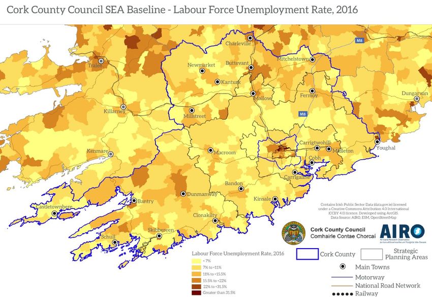
Scoping
                                                                                                  Report
                                                                                                   2019
   •   Consultation on the draft CDP and associated Environmental Report;
   •   Evaluation of the submissions and observations made on the draft CDP and Environmental
       Report prior to finalising the CDP;
   •   Issuance of an SEA Statement identifying how environmental considerations and
       consultation have been integrated into the final CDP.

Figure 1.1 overleaf gives an overview of the integrated Plan preparation, SEA, Habitats Directive
Assessment (HDA) and Strategic Flood Risk Assessment (SFRA) processes. The preparation of the
Draft Plan, SEA, HDA and SFRA are taking place concurrently and the findings of each will inform the
Draft Plan.
The process is currently at the stage where a Scoping Report has been prepared. This will be
subsequently updated to take account of any submissions received from the environmental
authorities.

Following the current Scoping Report stage, the Environmental Report will contain the findings of
the assessment of the likely significant effects on the environment resulting from implementation of
the CDP. It will reflect the requirements of the SEA Directive (2001/42/EC) on the assessment of the
effects of certain plans and programmes on the environment and also the transposed regulations in
Ireland (S.I. 436/2004) as amended in 2011.

                                                 3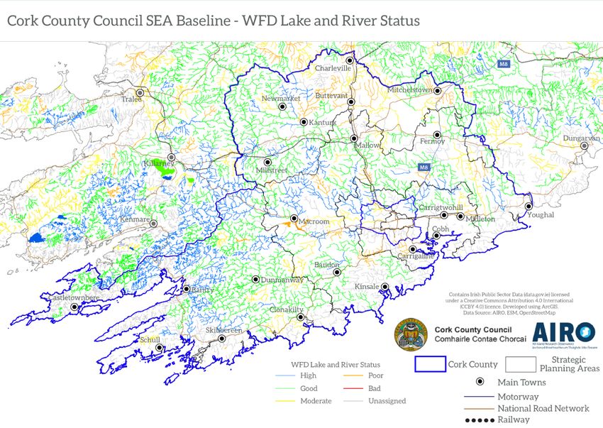
Scoping
                                                                                                      Report
                                                                                                       2019

                                Draft SEA Scoping - Current Stage
   Preparation of the SEA Scoping Report. What issues should be addressed within the Environmental
      Report and to what extent? Preparation of SEA Scoping Report (including HDA & SFRA issues)

                                            Consultation
       What are the views of SEA Statutory Authorities (minimum consultation requirement) and
                         incorporating them into the Environmental Report?

                                  Final SEA Scoping Issues Paper
    Following receipt of submissions from the Environmental Authorities the Scoping report shall be
                          finalised and uploaded to the local authority website

                                 Draft SEA Environmental Report
                Preparation of SEA Environmental Report and HDA and SFRA documents

                                            Consultation
  Public Consultation and consultation with Environmental Authorities - Draft Plan and SEA/HDA/SFRA
                                      documents on public display

             Submission and responses received on Draft Environmental Report
                Submissions are evaluated and responded to in Chief Executive's Report

                  Assessment of Proposed Material Alterations to Draft Plan
          Proposed Material Alterations and SEA/HDA Screening (and full SEA/HDA if needed)

                                            Consultation
            Public consultation - Draft Plan and SEA/HDA/SFRA documents on public display

                              Submissions and responses received
                Submissions are evaluated and responded in a Chief's Executive's Report

                     Modifications to Plan considered - SEA/AA Screening
                       Proposed Material Alterations and SEA/HDA consideration

                                           SEA Statement
                         Final, adopted Plan and accompanying SEA Statement

                                          SEA Monitoring
                                   Implementation and Monitoring

Taking into account the scope detailed in this report, environmental impacts will be predicted,
evaluated and mitigated. The findings of the assessment will be presented in an SEA Environmental
Report which will accompany the Draft Plan on public display as part of the required statutory public
consultation. Submissions will be responded to in the Chief Executive's report on public consultation,
with updates made to the SEA and HDA documentation where relevant.

                                                  4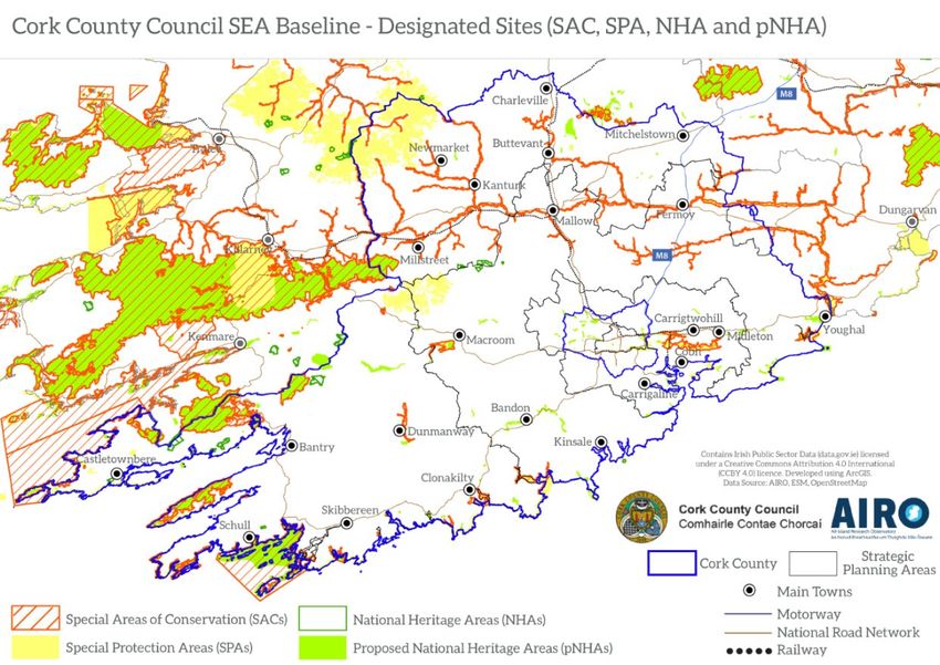
Scoping
                                                                                                     Report
                                                                                                       2019
In the case of any proposed Material Alterations these will be screened for the need to undergo SEA
and HDA and full, detailed assessments will be undertaken where required. The SEA and HDA
documents will accompany the Proposed Material Alterations on public display. Submissions will be
responded to in the Chief Executive's report on public consultation, with updates made to the SEA
and HDA documentation where relevant. Modifications will be examined to ensure that they would
not be likely to affect the Natura 2000 network of designated ecological sites and to ensure that they
would not be likely to result in significant environmental effects.

When the Plan is adopted, the SEA, HDA and SFRA documents will be finalised and an SEA
Statement, which will include information on how environmental considerations were integrated
into the Plan, will be prepared. The Plan will be implemented and environmental monitoring will be
undertaken.

4.0     SEA Guidance, Methodology and the integration of other assessments

The methodology followed in this report is derived from a number of sources including the
appropriate legislation and guidance documents prepared on a national and EU level.

The following principal sources of guidance will be used during the overall SEA process and during
preparation of the Environmental Report:
    • SEA Spatial Information Sources Inventory, June 2019, Environmental Protection Agency.
    • Strategic Environmental Assessment (SEA) Pack, 2018, Environmental Protection Agency.
    • SEA Effectiveness Review in Ireland - Action Plan 2018-2020
    • GISEA Manual, 2017, Environmental Protection Agency.
    • SEA Scoping Guidance Document, 2017, Environmental Protection Agency.
    • Integrating Climate Change into Strategic Environmental Assessment in Ireland - A Guidance
        Note, 2015, Environmental Protection Agency (Update expected late 2019).
    • Developing and Assessing Alternatives in Strategic Environmental Assessment – Good
        Practice Guidance, 2015, Environmental Protection Agency.
    • Environmental Protection Agency’s 2012 Review of SEA Effectiveness in Ireland.
    • Integrated Biodiversity Impact Assessment – Streamlining AA, SEA and EIA Processes:
        Practitioner’s Manual. EPA Strive Programme 2007-2013. Strive Report Series No. 106.
    • Strategic Environmental Assessment (SEA) Checklist - Consultation Draft. January 2008.
        Environmental Protection Agency.
    • Development of Strategic Environmental Assessment (SEA) Methodologies for Plans and
        Programmes in Ireland. Synthesis Report. 2003. Environmental Protection Agency.
    • Implementation of SEA Directive (2001/42/EC). Assessment of Certain Plans and
        Programmes on the Environment. Guidelines for Regional Planning Authorities. November
        2004. Department of Environment, Heritage and Local Government.

In addition a number of relevant circulars in relation to SEA have been issued which will have
relevance for the environmental assessment of the proposed County Development Plan and will be
taken into account during the course of the SEA. These circulars are as follows:

                                                 5
Scoping
                                                                                                        Report
                                                                                                         2019
      •   PSSP 6/2011: ‘Further Transposition of the EU Directive 2001/42/EC on Strategic
          Environmental Assessment (SEA)’; and
      •   Circular PL 9 of 2013: ‘Article 8 (Decision Making) of EU Directive 2001/42/EC on Strategic
          Environmental Assessment (SEA) as amended’.

4.1       Habitats Directive Assessment (HDA)

The Birds (2009/147/EC) and Habitats Directives (92/43/EEC) set out various procedures and
obligations in relation to nature conservation management in Member States in general, and of the
Natura 2000 sites and their habitats and species in particular. Natura 2000 sites are comprised of
Special Areas of Conservation (SACs) and Special Protection Areas (SPAs).

The Habitats Directive on the conservation of natural habitats and of wild fauna and flora obliges
member states to designate, protect and conserve habitats and species of importance in a European
Union context. Article 6(3) of the Habitats Directive requires that “Any plan or project not directly
connected with or necessary to the conservation of a site but likely to have a significant effect
thereon, either individually or in combination with other plans or projects, shall be subject to
appropriate assessment of its implications for the site in view of the site’s conservation objectives.”

This Directive was initially transposed into Irish Law through several pieces of legislation; however
these have now been consolidated into the European Communities (Birds and Natural Habitats)
Regulations 2011 (as amended). Any proposed plan or project in Ireland that has potential to result
in a significant effect on a designated European Site will require a HDA. Case law has determined
that the likelihood need not be great, merely possible, and that the precautionary principle must
apply as set out in European Commission Guidance and as required by CJEU case law (i.e. C 127/02
‘Waddenzee’).

The CDP is not directly connected to the conservation of any European Sites, however as a
countywide strategy, it has the potential to impact on habitats and species for which Special Areas of
Conservation (SAC) and Special Protection Areas (SPA) have been designated.
The HDA for the CDP is being carried out in parallel with the SEA process. The findings of the HDA
will be used to guide the development of the alternatives to be considered as part of the CDP and
SEA. The first stage of the HDA process is Screening, which is to determine whether implementation
of the CDP has the potential to have a significant effect on designated European Sites. Where likely
significant effects are identified then a Natura Impact Report will be required.

It is noted that there are requirements of the Birds and Habitats Directives that are not
encompassed by HDA e.g. annex IV species as per Articles 12 and 13 of the Habitats Directive,
landscape features outside designated sites which are of major importance for wild flora and fauna
as per Article 10 of the Habitats Directive and disturbance and deterioration of bird habitats as per
article 4(4) of the Birds Directive, these will be addressed in the SEA.

The SEA and HDA processes will facilitate the integration of environmental considerations into the
Plan. It is intended that these considerations will include the following:

                                                    6
Scoping
                                                                                                     Report
                                                                                                      2019
      •   Policies and objectives contributing towards environmental protection and management and
          the sustainable development; and
      •   Integration of environmental considerations into the land use zoning included as part of the
          Plan.

4.2       Strategic Flood Risk Assessment
Flood Risk Management aims to minimise the risks arising from flooding to people, property and the
environment. Natural floodplains merit protection to maintain their flood risk management function
as well as for reasons of amenity and biodiversity. These represent important elements of green
infrastructure.
In order to meet the needs of the Strategic Environmental Assessment process and the requirements
of the Department of the Environment, Heritage and Local Government / Office of Public Works
Guidelines, ‘The Planning System and Flood Risk Management’ (2009), Cork County Council intend to
carry out a Strategic Flood Risk Assessment (SFRA) of the County Development Plan. This will
provide an assessment of flood risk within the county and will inform land-use planning decisions for
this and other plans.
Updated Preliminary Flood Risk Assessment (PFRA) mapping is expected to be made available by the
Office of Public Works (OPW) later this year or early in 2020 and this will inform the SFRA of the
County Development Plan.

4.3       Climate Change
The SEA Directive provides plan-makers with a statutory framework to integrate climate-related
policies/objectives into plans and programmes. As part of the SEA process the EPA’s Guidance Note
‘Integrating Climate Change into Strategic Environmental Assessment in Ireland (2015)’ will be taken
into account. This guidance document states that the main climate change considerations to be
taken into account as part of the Scoping Stage should include the following:
  • Establish environmental (climatic) baseline;
  • Develop climate change Environmental Protection Objective(s);
  • Identify environmental vulnerabilities which may be affected significantly by climate change;
  • Consider adaptation and mitigation options to achieve the aims/goals of the policies, plans and
      programmes and strategies (PPPS); and
  • Early scoping consultation.

Environmental Sensitivity Mapping (ESM) has been used to examine the baseline information
available for both Climate Change and Biodiversity indicators and overlay both parameters to
identify which areas of the County are more sensitive to change. The ESM web-tool has been
developed by the EPA/ UCD/ AIRO/ OSI as a decision support tool for environmental assessment
processes in Ireland including SEA. The tool is described in more detail below in Section 6.1.

                                                   7
Scoping
                                                                                                              Report
                                                                                                               2019
5.0     Relationship with other plans and programmes

The County Development Plan is part of a hierarchy of local, regional and national plans. While it
should be consistent with higher-level plans such as those of a regional or national nature, it must
also guide or direct plans and programmes at a lower level hierarchically.

The County Development Plan will play a significant role in ensuring that the objectives and vision of
the Regional Spatial and Economic Strategy for the Southern Region and the National Planning
Framework (NPF) are implemented and integrated in a consistent manner at sub-regional and
county level. In considering the significant plans and programmes relevant to the review of the
County Development Plan the EPA’s Scoping Guidance document was consulted.

The following international, national, regional and local plans/programmes and legislation where
relevant will influence the policies contained in the CDP:

Table 5.1 – EU Legislation, Plans/ Policies/ Programmes
                                                   EU Legislation
       •   SEA Directive (2001/42/EC)                          •    Sewage Sludge Directive (86/278/EEC)
       •   EIA Directive (85/337/EC as amended)                •    Urban Waste Water Treatment Directive
       •   Habitats Directive (92/43/EEC)                           (91/271/EEC)
       •   Birds Directive (2009/147/EC-         codified      •    Nitrates Directive (91/676/EC)
           version of 79/409/EEC)                              •    Integrated Pollution    Prevention      Control
       •   Water Framework Directive (2000/60/EC)                   Directive (2008/1/EC)
           and associated directives which have been           •    Floods Directive (2007/60/EC)
           subsumed as follows: Drinking Water
                                                               •    Renewable Energy Directive (2009/28/EC)
           Abstraction Directive; Sampling Drinking
                                                                    and proposal for a revised directive
           Water Directive; Exchange of Information on
                                                                    (COM/2016/0767 final/2)
           Quality of Surface Freshwater Directive;
           Shellfish Directive; Freshwater Fish Directive;     •    Energy Efficiency Directive (2012/27/EU)
           Groundwater        (Dangerous      Substances)      •    Seveso III Directive (2012/18/EU)
           Directive; and Dangerous Substances
                                                               •    Clean Air for Europe (CAFE) Directive
           Directive
                                                                    (2008/50/EC)
       •   Drinking Water Directive (98/83/EC)
       •   Bathing Water Directive (revised) 2006
           (2006/7/EC)
       •   Groundwater Directive (2006/118/EC)
       •   Marine Strategy Framework             Directive
           (MSFD) (2008/56/EC)
       •   Maritime               Spatial        Planning
           Directive (2014/89/EU)

Table 5.2 – National Legislation

                                               National Legislation
       •   Planning and Development Act 2000 (as amended)
       •   Planning and Development (Amendment) Bill 2016
       •   Planning and Development (Strategic Environmental Assessment) Regulations 2004 (S.I. 436/2004) as

                                                      8
Scoping
Report
2019
National Legislation
amended by S.I. 201 of 2011;
• Planning and Development regulations 2001 (as amended)
• The Wildlife Act 1976 and Wildlife (Amendment) Act 2000
• European Communities (Birds and Natural Habitats) Regulations 2011 (S.I. 477 of 2011 as amended)
• Waste Management Act 1996 as amended
• Quality of Bathing Waters Regulations 1988 (S.I. 84 of 1988) as amended
• European Communities (Water Policy) Regulations 2003, (S.I. 722 of 2003)
• European Communities Environmental Objectives (Surface Water) Regulations (S.I. 272 of 2009)
• European Communities Environmental Objectives (FPM) Regulations 2009 (S.I. 296 of 2009)
• European Communities Environmental Objectives (Groundwater) Regulations 2010
(S.I. 9 of 2010)
• European Communities (Good Agricultural Practice for Protection of Waters) Regulations 2014 (S.I.
No. 31 of 2014)
• Quality of Bathing Waters Regulations 1988 (S.I. 84 of 1988) as amended
• Climate Action and Low Carbon Development Act 2015
Table 5.3– National/Regional Plans/Policies/Programmes
National/ Regional & Local Plans/ Policies/ Programmes
• National Planning Framework (NPF) • National Broadband Plan
• National Development Plan 2018-2027 Intervention Strategy (Draft)
• Southern Regional Spatial and Economic • National Landscape Strategy for Ireland
Strategy (RSES) 2015 – 2025
• Building on Recovery: Infrastructure and • Healthy Ireland – a Framework for
Capital Investment (2016-2021) (DPER, Improved Health and Wellbeing 2013-
2015) 2025
• Rebuilding Ireland, Action Plan for Housing • Sustainable Rural Housing Guidelines
and Homelessness • Wind Energy Guidelines
• Capital Investment Plan 2016-2021 • Rural Development Programme (RDP)
• National Policy Position on Climate Action 2014- 2020
• National Climate Change Mitigation Plan • Realising our Rural Potential, Action Plan
for Rural Development
• Adapting to Climate Change - National
Adaptation Framework 2018 and sectoral • Ireland’s Fourth Nitrates Action Programme
Adaptation Plans • Forestry Programme 2014-2020
• Climate Action Plan 2019 • Forest Policy Review: Forests, Products
• National Clean Air Strategy (Draft) and People – A Renewed Vision (2014)
• Draft Bioenergy Plan 2014 • Food Wise 2025 – Department of
Agriculture, Food and MarineSouth West
• Second Cycle River Basin Management
Region Action Plan for Jobs 2015
Plan 2018-2021
• Organic Farming Scheme Catchment Flood
• Irish Water - Water Services Strategic Plan
Risk and Management Studies
2015
• Flood Risk Management Plans
• National Water Resources Plan [in prep]
• European Structural & Investment Funds
• Lead in Drinking Water Mitigation Plan
2014-2020
• National Wastewater Sludge Management
• National Heritage Plan (2002)
Plan 2016
9Scoping
Report
2019
• Aquaculture Plan 2014 • Smarter Travel – A Sustainable Transport
• National Biodiversity Action Plan 2017-2021 Future 2009-2020
• All-Ireland Pollinator Plan 2015-2020 • Culture (2025)
• National Peatlands Strategy 2015 • Sustainable Development: A Strategy for
Ireland (1997) (DEHLG)
• Southern Region Waste Management Plan
2015- 2021 • Cork County Council Local Economic and
Community Plan (2016)
• Delivering a Sustainable Energy Future for
Ireland (Energy White Paper) 2007 and • Cork County Biodiversity Action Plan 2009-
2015 update 2014
• National Renewable Energy Action Plan • Cork County Council’s Climate Adaptation
Strategy 2019
• Strategy for Renewable Energy 2012-2020
• Cork County Landscape Character
• Offshore Renewable Energy Development
Assessment 2007
Plan 2030
• Cork City Development Plan 2015-2021The
• Harnessing Our Ocean Wealth
Planning System and Flood Risk
• National Cycle Policy Framework 2009-2020 Management Guidelines for Planning
• National ITS Strategy (Draft) Authorities, 2009
• National Hazardous Waste Management • Regional Development Strategy 2035
Plan 2010-2020
• NPWS Conservation Plans and/
• Construction 2020 or Conservation Objectives for SAC and
SPAs
6.0 Baseline gathering
In order to assess the likely significant impacts of the Plan, baseline data on the current state of the
environment is collected and evaluated and the potential effects of the plan predicted and
considered. Therefore the purpose of the baseline description is to identify the current state of the
environment, against which the likely effects of implementing the plan can be assessed. In
accordance with legislation and guidance, the existing environment is described with respect to
biodiversity, population, human health, fauna, flora, soil, water (surface freshwater, coastal,
transitional, groundwater, bathing and water services (drinking water and waste water treatment),
air, climatic factors, material assets (roads, transportation, energy etc), cultural heritage (including
architectural and archaeological heritage), landscape and the interrelationships between these
factors as appropriate. Any existing problems relevant to the new Plan are also identified at this
baseline stage.
Identification of baseline environmental status provides for the identification of key resources and
sensitivities within the Plan area and the identification of potential threats to the environment, thus
allowing for the inclusion of mitigation measures later in the process that may need to be
incorporated into the new Plan to ensure that it does not exacerbate existing problems. Assessment
of the baseline environment also enables plan-makers to consider how the environment might
evolve in the absence of the proposed plan.
In line with the SEA Directive, an environmental baseline will be compiled for the Draft Cork County
Development Plan. The SEA Environmental Report will present a full description of the relevant
aspects of the environmental baseline data. The baseline will reflect the strategic nature of the CDP.
10Scoping
Report
2019
The environmental baseline will be presented in the Environmental Report under a number of
Strategic Environmental Assessment topic headings as follows:
Biodiversity, Flora and Fauna;
Population;
Human Health;
Soil ;
Water;
Air Quality and Climatic Factors;
Material Assets;
Cultural Heritage including Architectural and Archaeological Heritage; and
Landscape.
Outlined in the following sections are brief descriptions of the current state of the environment
within Cork County. A non-exhaustive summary of the data sources to be used as part of the
process is given in Table 6.1 overleaf:
Table 6.1 – Baseline Data Sources
SEA Topic Potential Data Sources
National Parks and Wildlife Service (NPWS) database;
National Biodiversity Data Centre;
Irelands National Biodiversity Plan;
Biodiversity, Flora and Fauna
Invasive Species Ireland website;
WFD Ireland website;
MSFD Ireland website;
EPA Geoportal.
Population Central Statistics Office (CSO) database, including census 2016 data
EPA Geoportal;
Human Health
Central Statistics Office (CSO) database, including census 2016 data;
See also Soils, Water and Air Quality entries.
Corine Land Cover and Land Use Database;
Soils Coillte Forestry Database;
Teagasc Soil Information;
Geological Survey of Ireland Online Mapping.
EPA ENVision (Environmental Mapping); EPA Geoportal;
EPA database reports including but not limited to: Water Quality in
Ireland (latest available); Integrated Water Quality Reports (latest
Water available); and Quality of Estuarine and Coastal Waters (latest
available);
National Catchment Flood Risk Management Programme (CFRAM),
Office of Public Works (OPW) (Flooding);
11Scoping
Report
2019
EPA database (air quality);
Air Quality Local Authority air quality monitoring network.
Ireland’s Greenhouse Gas Emission Projections, EPA (latest available);
Climatic Factors Sustainable Energy Ireland (SEAI)
EPA GeoPortal;
Material Assets OPW flood data;
DAFM datasets;
DCCAE datasets.
Cultural Heritage including National Monuments Service (Archaeological Survey Database);
Architectural and National Inventory of Architectural Heritage.
Archaeological Heritage Record of Protected Structures (RPS).
Landscape Character Areas (County level)
Landscape Landscape Character types (County level)
6.1 Environmental Sensitivity Mapping (ESM)
In addition to the above data sources Cork County Council is piloting the use of Environmental
Sensitivity Mapping at County Development Plan Level. The ESM web-tool developed by the EPA,
UCD, OSI and AIRO of Maynooth University has been developed as a decision support tool for
environmental assessment processes in Ireland including SEA. It is worth noting that SEA is not a
decision making tool but a decision informing tool and the ESM will support the SEA process in
informing these decisions through up to date data visualisations.
The ESM webtool uses spatial data sets with specific layers attributed a pre-defined scientific score.
When these layers are examined together and over laid, an environmental sensitivity map is
generated for the relevant area. Where more sensitivities are present in an area the colour overlay
turns from green to orange to red.
The areas of red displayed on the maps (as illustrated in Figure 6.1.1 below and the following
sections) do not necessarily mean that development will be restricted in the area but rather that
more consideration of the environmental sensitivities will be required and mitigation measures
may be needed where development is permitted. It is worth noting that many of the red areas
displayed are areas of natural capital such as valuable habitats, landscapes and scenic areas,
ensuring protection and enhancement of these areas will be a key policy aim of the development
plan.
Cork County Council is using this mapping tool to examine the sensitivities in relation to the different
environmental topics but also to assess the cumulative/in-combination sensitivities within certain
geographical areas i.e. countywide, river catchments, coastal areas etc. Where relevant datasets
were made available maps have been generated to illustrate the associated sensitivities, a selection
of these maps have been included under the SEA environmental topics below. Figure 6.1.1 below
illustrates a ‘countywide environmental sensitivity scenario’ where all relevant environmental
datasets from each of the SEA environmental topics have been overlaid and areas of varying
environmental sensitivity are shown.
12Scoping
Report
2019
Figure 6.1.1 –Environmental Sensitivity Map for Cork County and surrounding areas Data source – ESM
13Scoping
Report
2019
6.2 Biodiversity – Flora and Fauna
The Plan area is rich in biodiversity, containing many important, and protected, habitats and species
such as rivers, lakes, wetlands, coastal areas, woodlands, bats, wildfowl, waders, salmon, lamprey,
freshwater pearl mussel, otters etc. However, it also contains many other habitats which are not
protected such as scrub, parks, streams, hedgerows, tree lines, roadside verges, housing estate open
spaces and gardens. It is these locally important habitats and species within the landscape, including
extensive areas of wetland, broadleaf woodlands and grasslands, which provide links between the
more rare and protected habitats, and are essential for the migration, dispersal and genetic
exchange of wild plants and animals.
In addition to the above the natural environment provides ecosystem services in the form of food,
fuel, water purification, flood alleviation and more.
Under Article 11 of the Directive, each member state is obliged to undertake surveillance of the
conservation status of the natural habitats and species in the Annexes and under Article 17, to
report to the European Commission every six years on their status and on the implementation of the
measures taken under the Directive. The latest version of the Status of EU Protected Habitats and
Species in Ireland was published in August 2019. This publication provides a synopsis for each of the
listed habitats and species occurring in Ireland. The report found that 46% of habitats are
demonstrating ongoing declining trends.
European and National Legislation protect the most valuable of our remaining wild places, habitats
and species through designation of sites as Special Areas of Conservation (SACs) and Special
Protection Areas (SPAs) proposed Natural Heritage Area (pNHAs) and Natural Heritage Areas (NHAs).
The SEA Environmental Report of the Draft CDP will consider available information on these
designated ecological sites and protected species, ecological connectivity and non designated
habitats within the plan area. The assessment will include data available from those sources listed in
Table 6.1 on the previous page and any additional sources that may emerge as part of the process.
Figure 6.2.1 below contains the locations of all designated sites within the County and through the
use of ESM, a map has also been formulated to show the areas which have increased sensitivity to
change, these include areas occupied by sensitive habitats and species and also areas with sensitive
water environments or other know environmental constraints.
14Scoping
Report
2019
Figure 6.2.1 – Designated sites in Cork County and surrounding areas Data source – ESM and NPWS
15Scoping
Report
2019
There are 30 SACs, 18 SPAs and 9 NHAs within the county. Details of each site are contained in
tables 6.1 to 6.3 overleaf. A detailed list of all designated sites and their respective qualifying
interests will be included in the environmental report.
Other considerations under this topic which will be assessed in the Environmental Report include the
list below, which is not exhaustive:
Ecological connectivity and networks – to demonstrate the requirements of Article 10 of the
Habitats Directive are being met.
Ramsar Sites - designated under the Convention on Wetlands of International Importance.
Wildfowl Sanctuaries (provided for by Statutory Instrument No. 192 of 1979);
Freshwater Pearl Mussel Catchments - Freshwater pearl mussel is a globally threatened,
long-lived and extremely sensitive species that can be impacted by many forms of pollution,
particularly sediment and nutrient pollution and by hydrological and morphological changes,
which may arise from developments, activities or changes in any part of the catchment.
Water Framework Directive Register of Protected Areas - These areas are those identified as
those requiring special protection under existing national or European legislation, either to
protect their surface water or groundwater, or to conserve habitats or species that directly
depend on those waters.
Blue Dot Programme - The EPA in combination with the DHPCLG have identified a network
of High Status Objective sites and water bodies. These are monitoring locations which are
currently at high or close to high status and which have been identified as high status
objective sites under the Water Framework Directive.
Watercourses, wetlands and peat lands – sites of biodiversity interest both inside and
outside of designated sites.
Shellfish Areas - Shellfish production areas listed in the Irish Shellfish Regulations (S.I.
200/1994) and European Communities (Quality of Shellfish Waters) (Amendment)
Regulations 2009.
Maps illustrating each of the above will be included in the environmental report and ESM will be
used to examine the cumulative impacts of certain policies and objectives on the plan area. Figure
6.2.2 below shows the locations existing and previously recorded populations of Freshwater Pearly
Mussel in Cork County.
In accordance with requirements under the EU Habitats Directive (92/43/EEC) and EU Birds Directive
(2009/147/EC) and Section 177 of Part XAB of the Planning and Development (Amendment) Act
2010, the impacts of the policies and objectives of all statutory land use plans on designated sites
must be assessed as an integral part of the process of making a land use plan.
The SEA will be informed by the findings of the Habitat Directive Assessment/Natura Impact Report
and will follow elements of Integrated Biodiversity Assessment with reference made to the EPA's
2013 Integrated Biodiversity lmpact Assessment - Streamlining AA, SEA and EIA Processes:
Practitioner's Manual.
16Scoping
Report
2019
Figure 6.2.2 – Freshwater Pearl Mussel Catchments in Cork County Data source – ESM and NPWS
17Scoping
Report
2019
Table 6-1: Special Areas Of Conservation in County Cork
Site Code Site Name Site Code Site Name
002036 Ballyhoura Mountains SAC 000090 Glengarriff Harbour and Woodland SAC
000077 Ballymacoda (Clonpriest and 001058 Great Island Channel SAC
Pillmore) SAC
002171 Bandon River SAC 002158 Kenmare River SAC
001040 Barley Cove to Ballyrisode Point 001061 Kilkeran Lake and Castlefreke Dunes SAC
SAC
002170 Blackwater River 000365 Killarney National Park, Macgillycuddy's Reeks
(Cork/Waterford) SAC and Caragh River Catchment SAC
000093 Caha Mountains SAC 000097 Lough Hyne Nature Reserve and Environs SAC
002037 Carrigeenamronety Hill SAC 002165 Lower River Shannon SAC
001547 Castletownshend SAC 001890 Mullaghanish Bog SAC
001043 Cleanderry Wood SAC 001070 Myross Wood SAC
000091 Clonakilty Bay SAC 002281 Reen Point Shingle SAC
001230 Courtmacsherry Estuary SAC 000101 Roaringwater Bay and Islands SAC
001873 Derryclogher (Knockboy) Bog SAC 000102 Sheep's Head SAC
002280 Dunbeacon Shingle SAC 0001 St. Gobnet's Wood SAC
06
002189 Farranamanagh Lough SAC 000108 The Gearagh SAC
001879 Glanmore Bog SAC 000109 Three Castle Head to Mizen Head SAC
Table 6-2: Special Protection Areas in County Cork
Site Code Site Name Site Code Site Name
004022 Ballycotton Bay SPA 004162 Mullaghanish to Musheramore Mountains SPA
004023 Ballymacoda Bay SPA 004021 Old Head of Kinsale SPA
004155 Beara Peninsula SPA 004191 Seven Heads SPA
004094 Blackwater Callows SPA 004156 Sheep's Head to Toe Head SPA
004028 Blackwater Estuary SPA 004124 Sovereign Islands SPA
004081 Clonakilty Bay SPA 004161 Stack's to Mullaghareirk Mountains, West
Limerick Hills and Mount Eagle SPA
004030 Cork Harbour SPA 004066 The Bull and The Cow Rocks SPA
004219 Courtmacsherry Bay SPA 004109 The Gearagh SPA
004190 Galley Head to Duneen Point SPA 004162 Mullaghanish to Musheramore Mountains SPA
Table 6-3: Natural Heritage Areas in County Cork
Site Code Site Name Site Site Name
Code
002447 Boggeragh Mountains NHA 002449 Mount Eagle Bogs NHA
002386 Conigar Bog NHA 002416 Pulleen Harbour Bog NHA
002105 Derreennatra Bog NHA 000105 Sovereign Islands NHA
001059 Hungry Hill Bog NHA 002371 Trafrask Bog NHA
002417 Leahill Bog NHA
18Scoping
Report
2019
6.2.1 Links between Biodiversity, Climate Change and Flooding
Climate change is regarded as the biggest environmental issue facing the world today. The release of
greenhouse gases, such as carbon dioxide, is regarded as one of the main drivers of climate change.
Biodiversity, and particularly plants, play a significant role in removing this carbon dioxide from the
atmosphere and storing it through photosynthesis. However, activities which lead to a loss of
vegetation prevent this critical service from occurring, while activities such as the drainage of
peatlands can actually release more carbon dioxide into the atmosphere. The rate of biodiversity
loss across the world has been inextricably linked to the rate of global climate change. However,
there has been an increasing move towards trying to adapt to climate change, rather than trying to
stop it, and in this regard, biodiversity has another significant role to play, particularly in relation to
flood attenuation.
Wetlands, such as bogs, fens and marshes, slow down the flow of water, and so help to regulate
flooding, however, their loss not only exacerbates the level of flooding, but also its speed, which
leads to flash flooding. Wetlands can contain huge volumes of water (bogs, for example, are made
up of over ninety percent water) and when a wetland is drained, the water must go somewhere, and
water will always flow to the lowest lying areas. The protection and retention of river floodplains
from infilling, reclamation or development is also vitally important to ameliorate the impacts of
flooding.
Figure 6.2.3 overleaf illustrates an environmental sensitivity map that has been formulated by
overlaying sensitive ecological designations and areas of know habitats and species with known data
sets used to measure the impact of climate change e.g. flood extent scenarios, vegetation carbon
and water retention capacity. The resultant map illustrates those areas that are most sensitive to
climate change.
19Scoping
Report
2019
Figure 6.2.3 –Environmental Sensitivity Map illustrating Climate Change and Biodiversity Scenario. Data source – ESM
20Scoping
Report
2019
6.3 Population and Human Health
The National Planning Framework makes provision for the population of Cork City and County to
grow to about 770,000 by 2040. The draft Regional Spatial and Economic Strategy for the Southern
Region including the Cork Metropolitan Area Strategic Plan (MASP) includes interim population
targets to 2026 and 2031. The population of Cork County is targeted to grow by nearly 105,000
people to about 437,000 people by 2040.
It is important to acknowledge that on the 31st of May 2019 the boundary of County Cork changed
bringing with it all of the associated rearrangements of Municipal Districts and Local Electoral Areas
following enactment of the relevant provisions of the Local Government Act, 2019 and the Local
Electoral Area Boundary Committee No. 1 Report 2018. Where Census Data is used for tables and
graphs in this document – these will generally refer to the old boundaries – i.e. the boundaries that
were in effect during the last census (2016). Where information relates to new future population
targets the new boundaries are used.
The 2016 Census population data for Cork suggests that there is evidence of a continuation of strong
growth with an increase of population from 399,802 to 417,211 (17,409) or a 4.3% increase from the
2011 Census. In addition, the data indicates a trend of people returning to live in Cork City with a
5.4% increase (6,392 people) in population from the previous Census in 2011. The following bar
chart highlights the changes in population in both the County and City from 1951 to 2016.
Cork City and County Population
Census 1951-2016
600000
500000
400000
300000
200000
100000
0
1951 1961 1971 1981 1991 1996 2002 2006 2011 2016
Cork City (Old boundary) Cork County (Old Boundary) Total City and County
Figure 6.3.1 – Bar chart highlighting the changes in population in both the County and City from 1951 to
2016 Data source – www.cso.ie
The Core Strategy of the Cork CDP allocates population and housing growth across the towns,
villages and rural parts of the county. The current allocation for population growth for each
Strategic Planning Area, as provided for by the County Development Plan 2014, and adjusted to take
account of the boundary changes 3 and is set out in Table 6.3.2 below. The current population of
3
See Appendix 1 for the Core Strategy tables from the CDP 2014 for the old administrative boundary
21Scoping
Report
2019
Cork County is 332,015, this excludes Cork City and any areas that were transferred to the City
Council.
Table 6.3.2: Core Strategy 2014 by Strategic Planning Area
4
Strategic Planning Area 2011 Census Pop 2022 Target Pop 2016 Census Pop
Metropolitan Cork (adjusted for new boundaries)
Main Towns 49,464 76,191 53,904
Villages and Rural (Not available) (Not available) 40,649
Total SPA (Not available) (Not available) 94,553
Greater Cork Ring
Main Towns 41,300 54,727 43,010
Villages and Rural 77,118 77,155 81,960
Total SPA 118,418 131,882 124,970
North Cork
Main Towns 13,039 17,117 13,510
Villages and Rural 37,405 38,895 38,091
Total SPA 50,498 56,012 51,601
West Cork
Main Towns 13,894 19,900 13,307
Villages and Rural 46,483 48,937 47,584
Total SPA 60,377 68,837 60,891
Total County 332,015
Data Source: www.corkcocodevplan.com and www.cso.ie
63% of the population of the county live in rural areas (including village settlements) and 37% live in
urban areas. Table 6.3.2 shows that growth in the villages and rural area of the Greater Cork Ring
recorded substantial growth while the towns did not perform as well as expected. Indeed,
population levels in the main towns were well below target across all Strategic Planning Areas.
The allocation of future growth for County Metropolitan Cork as set out in the NPF and the RSES is
49,000 additional people to 2040 – which is about 47% of the total growth allocated to Cork County.
The remainder of this growth – 55,000 people will be divided up between the Greater Cork Ring
Strategic Planning Area, the West Strategic Planning Area and the North Strategic Planning Area.
Figure 6.3.2 below shows a population pyramid illustrating the CSO data available for the number of
males and females in 2016, by single year of age. It is evident from the pyramid that in Cork County
there is a definite increase in the years 3-9 which taper back to the birth rate by age 18, indicating a
previous baby boom. The more typical pyramid shape is evident from mid-30’s which tapers out as
expected especially over 80 years of age – with slightly more females showing at the tip of the
pyramid in both areas.
4
Some of the Census towns which previously combined legal towns and their environs have been newly defined using the standard census
town criteria (with the 100 metres proximity rule). For some towns the impact of this has been to lose area and population, compared
with previous computations – one such example is Bantry town.
22Scoping
Report
2019
Figure 6.3.2 – Population pyramid illustrating census 2016 data for Cork County
With regard to household numbers and available private and public infrastructure in the County,
there are 52,096 permanent private households serviced by individual septic tanks in County Cork,
5,690 are served by individual treatment systems that are not septic tanks. There are 81,832
permanent private household served by public sewerage schemes (Census 2016). There are 103,347
permanent private households getting their water supply from public mains, 4,295 from the local
authority group schemes, 2,159 from private group schemes and 31,759 from other private sources
(Census 2016).
The ESM tool has been used to inform the baseline information on other elements of the population
also, including deprivation levels and unemployment rates in the County. An examination was
conducted using CSO data from the 2016 Census and the maps illustrated below were generated.
Figure 6.3.3 shows the deprivation index for the County, those areas that are suffering with
economic difficulties and in contrast those areas recording affluence can be seen. Large areas of
west and north Cork are recording marginally below average levels of deprivation.
Figure 6.3.4 again uses data from the Census 2016 to determine the levels of unemployment
throughout the county. This information will inform the CDP economic strategy in the future. There
is also a known strong link between levels of unemployment and health issues amongst the general
population. More information on this topic can be found in the Economy and Employment
background document.
23Scoping
Report
2019
Figure 6.3.3 – Pobal HP Deprivation Index, 2016. Data source – www.cso.ie and ESM
24Scoping
Report
2019
Figure 6.3.4 – Labour Force Unemployment Rate, 2016. Data source – www.cso.ie and ESM
25Scoping
Report
2019
6.4 Soils & Geology
Soil is a valuable resource that performs many ecosystem services: production of food; production of
biomass; storage, filtration and transformation of nutrients and water; carbon storage and cycling;
and contributes to the landscape and cultural environment. Figure 6.4.1 below details the various
different spoil types that are present in Cork County.
In the northern, eastern and southern parts of the County the soils are predominantly acid/ basic
deep well‐drained mineral soils such as Brown Podzolics. These are good productive agricultural soils
with a wide range of uses, particularly suitable for arable farming, which should be protected where
possible. To the northwest of the County, there are heavy textured gley soils which are poorly
drained due to a combination of heavy texture, gently undulating topography and/or high ground-
water level. Poorly drained mineral soils, shallow lithosolic‐podzolic types and peats are more
common along the western Atlantic margins of West Cork.
High Level Blanket Peat soils and Low Level Peat soils are found in western and north-western parts
of the County. High Level Blanket Peat soils occur above 150 metres and also at the higher levels in
mountain areas in the western parts of the County. Low Level Peat soils occur in flat or undulating
topography below the 150 m contour line. These soils have limited agricultural value but often have
important nature conservation value and also are important carbon sinks which need to be
preserved to combat further climate change.
There are 103 sites of geological interest in County Cork which are afforded protection in the current
County Development Plan. Some of the sites listed are also protected under Natural Heritage Area
Designations.
Figure 6.4.2 presents an overview of the land cover types present in the County. It gives an
interesting perspective on the various areas of natural and anthropogenic land uses and may be
used to inform future decisions on areas suitable for development.
26Scoping
Report
2019
Figure 6.4.1 – Soil Types in County Cork. Data source –National Soil Survey and ESM
27Scoping
Report
2019
Figure 6.4.2 – Corine Land Cover map of County. Data source – EPA and ESM
28Scoping
Report
2019
6.5 Water
County Cork has the greatest number of rivers of any county in Ireland including the Argideen,
Bandon, Blackwater, Bride, Glashaboy, Ilen and the Lee. Notably, most major rivers in the County
run from west to east.
The most recent data on the existing water quality in County Cork for the period 2010-2015 is
illustrated in figure 6.5.1 and shows that the majority of our river and coastal water bodies have
achieved good or high status, while our lakes and transitional waters have significantly higher
percentages of poor status water bodies. To date, water protection efforts have succeeded in
reducing the extent of serious pollution in rivers but there remains a need to improve the status of
others which are currently at less than good ecological status.
River 24 54 14 8
Lake 27 36 36
Transitional 9 64 27
Coastal 11 67 11 11
0% 10% 20% 30% 40% 50% 60% 70% 80% 90% 100%
High Good Moderate Poor Bad
Fig. 6.5.1 Water Quality Status for the period 2010-2015
Data Source: EPA – Catchments.ie website
Under the EU Water Framework Directive Ireland is obliged to produce a River Basin Management
Plan (RBMP) and the current plan covers the period 2018-2021. The plan details a series of actions
to protect and improve water quality and achieve good ecological status in all our waterbodies by
2027. Water quality data for Cork County back to 2007 shows a worrying trend, with deterioration in
the number of waterbodies achieving good status (down from 59% to 51% between 2007 and 2015)
and corresponding increases in the number of moderate and poor ranked waterbodies.
Time Period High Good Moderate Poor Bad
2007-2009 22% 59% 14% 5% 1%
2010-2012 23% 54% 16% 6% 0%
2010-2015 22% 51% 17% 10% 0%
Fig. 6.5.2 Water Quality Status for all Surface Waters - Trend 2007-2015
Source: EPA – Catchments.ie website
29Scoping
Report
2019
Figure 6.5.3 below shows current data in relation to the WFD Lake and River status for the various
different water bodies throughout the county. No water body currently has a ‘bad’ status, the
challenge for the next County development Plan will be to improve on the current situation and
ensure there is no deterioration of current ‘poor’ status water bodies.
An examination was conducted of the data available on the ‘at risk’ waterbodies throughout the
county, these are waterbodies which are at risk of deteriorating or not achieving ‘Good’ ecological
status by 2021 (2nd Water Framework Directive (WFD) cycle). Risk status is assigned based on the
latest ecological status, water quality trends and distance to thresholds assessments (source: EPA –
https://www.catchments.ie/maps/). The catchments of the Blackwater, Lee and Bandon rivers in
particular show high proportion of “at risk” water bodies. Similarly, water bodies in east and
northeast Cork, particularly, in the vicinity of Charleville, Buttevant and Mitchelstown are also “at
risk” of not meeting the requirements of the Water Framework Directive.
In the case of estuarine water bodies, those “at risk” in Cork County include the Lower Blackwater
Estuary and Youghal Harbour, Cork Harbour, Owenaboy Estuary, Kinsale harbour, Ardigeen Estuary,
Coutmacsherry Bay, Clonakility Bay and harbour, Rosscarbery Bay and Harbour, Ilen Estuary, lough
Mahon and the Owenacurra Estuary. The assimilative capacity of receiving waters is particularly
important in sensitive ecological catchments such as those that host Freshwater Pearl Mussel
(FWPM) e.g. Ownagapul River, Eyeries. Water abstraction and impacts on water quality are two of
the main threats to future FWPM populations.
All rural houses in unserviced areas rely on individual onsite waste water treatment facilities and
water supplies. It is essential, in terms of public health and protecting groundwater and overall
environmental quality, that the original site selection process verifies that the site is suitable for such
development in the first instance and that the waste water treatment systems are correctly
designed, installed and maintained over its lifetime.
30You can also read