Bushfire Management Plan - (Structure Plan) PARKRIDGE ESTATE Lot 9004, 9503 & 9504 Peninsula Lakes Drive, Eaton - Shire of Dardanup
←
→
Page content transcription
If your browser does not render page correctly, please read the page content below

Bushfire Management Plan
              (Structure Plan)
             PARKRIDGE ESTATE
            Lot 9004, 9503 & 9504
     Peninsula Lakes Drive, Eaton

                   LUSH FIRE & PLANNING
                             3 Paterson Rd
                          Pinjarra WA 6208
                              0418 954 873
                       ABN 74 232 678 543

                                Ref 17-076
                                     Ver C
                                June 2019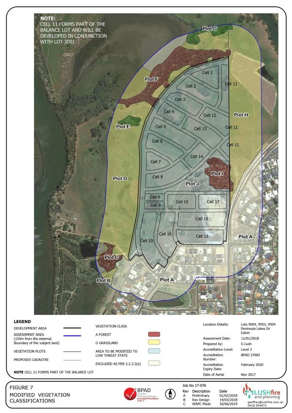
Site Address / Plan Reference:          Lot 9004 Peninsula Lakes Drive

 Suburb:     Eaton                                                                    State:   WA           P/code:         6232

 Local government area:                  Dardanup

 Description of the planning proposal:            Structure Plan Modifications

 BMP Plan / Reference Number:            17-076                    Version:      C                 Date of Issue:     25/06/2019

 Client / Business Name:                 Parkridge Group Pty Ltd

 Reason for referral to DFES                                                                                          Yes          No

 Has the BAL been calculated by a method other than method 1 as outlined in AS3959 (tick no if
 AS3959 method 1 has been used to calculate the BAL)?                                                                  ☐           ☒
 Have any of the bushfire protection criteria elements been addressed through the use of a
 performance principle (tick no if only acceptable solutions have been used to address all of the BPC                  ☐           ☒
 elements)?

 Is the proposal any of the following special development types (see SPP 3.7 for definitions)?

 Unavoidable development (in BAL-40 or BAL-FZ)                                                                         ☐           ☒
 Strategic planning proposal (including rezoning applications)                                                         ☒           ☐
 Minor development (in BAL-40 or BAL-FZ)                                                                               ☐           ☒
 High risk land-use                                                                                                    ☐           ☒
 Vulnerable land-use                                                                                                   ☐           ☒
If the development is a special development as listed above, explain why the proposal is considered to be one of the above
listed classifications (E.g. considered vulnerable land-use as the development is for accommodation of the elderly, etc.)?

Note: The decision maker (e.g. the local government or the WAPC) should only refer the proposal to DFES for comment if
one (or more) of the above answers are ticked “Yes”.

 BPAD Accredited Practitioner Details and Declaration

 Name                                               Accreditation Level              Accreditation No.          Accreditation Expiry
 Geoffrey Lush                                      Level 2                          BPAD 27682                 28/02/2020
 Company                                                                             Contact No.
 Lush Fire & Planning                                                                0418 954 873

I declare that the information provided in this bushfire management plan is to the best of my knowledge true and correct.

 Signature of Practitioner                                                                  Date         25/06/2019
Parkridge Estate Eaton                                                      Executive Summary

This bushfire management plan is prepared for the proposed subdivision and development of the
Parkridge Estate at Eaton.

The aim of this Report is to reduce the threat to the residents in the proposed subdivision in the
event of a bushfire within or adjacent to the development. It demonstrates:
   •    How the hazard level will be reduced and maintained for the life of the development.
   •    That compliance with the Bushfire Protection Criteria in the Guidelines can be achieved.

The subject land is located approximately8km east-north-east of the Bunbury CBD adjacent to the
Collie River. It is situated between Eaton Drive and the river. It has an area of an area of 53
hectares and its main topographical feature is the flood plain associated with the Collie River. The
principal area of remnant vegetation is located along the river corridor with some small areas
extending into the subject land. The site is gently undulating with low gradients of less than 5
degrees.

The development site is approximately 30 hectares in size and situated on the eastern portion of
the subject land. There is an additional area of 1.5 hectares immediately adjacent to the Collie
River which is elevated and not flood prone.

There are potentially three stages of development with an overall yield of 527 lots with a
combination of R20 and R40 densities.
   •    North stage - 316 lots; and
   •    South stage - 211 lots.

A local open space reserve being approximately 3.3 hectares will be provided centrally within the
Estate and a portion of this will retain the existing vegetation.

The north eastern portion of the development adjacent to the boundary of Lot 3001 will be left as
part of the balance lot pending the development of Lot 3001. This is because there will be some
common lots crossing the property boundary and is also allows this land to be used as an asset
protection zone pending completion of the final subdivision.

An emergency access way will be created through Lot 3001 along the alignment of proposed
subdivision road giving secondary access to Eaton Drive.

All of the proposed lots will have a Bushfire Attack Level of BAL-29 rating or less. Two residential
cells have a 3m encroachment of BAL-40/FZ on their front boundary. This equates to the minimum
development setback under the R-Codes and will be reinforced by the use of a restrictive covenant.
The majority of lots in the Estate will have a BAL-12.5 or BAL-Low rating.

The proposed subdivision complies with the objectives of State Planning Policy 3.7 as:
   1.   It avoids any increase in the threat of bushfire to people, property and infrastructure.
        Development with a maximum BAL-29 rating it does not increase the threat of bushfire.
        The proposed subdivision design does not increase the bushfire threat as it complies with
        the Bushfire Protection Criteria and provides for the management of vegetation hazards,
        suitable road access and appropriate separation distances with all proposed lots having a
        BAL-29 rating or lower.

   2.   It reduces vulnerability to bushfire through the identification and consideration of bushfire
        risks in the design of the development and the decision-making process.
        The bushfire hazard and risks have been identified and assessed in this report.

                                                                                                   (i)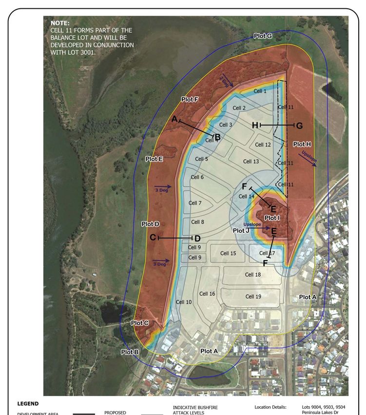
Parkridge Estate Eaton                                                     Executive Summary

   3.   The design of the subdivision and the development takes into account bushfire protection
        requirements and includes specific bushfire protection measures.
        The proposed development complies with the Bushfire Protection Criteria.
   4.   Achieves an appropriate balance between bushfire risk management measures and
        biodiversity, conservation values, and environmental protection.
        The vegetation on the site which is to be cleared for any development does not have any
        significant conservation value. The river foreshore and wetlands will be rehabilitated and
        provision for this has been included in the design and assessment.

The recommendations in this report should not be construed to assure total bush fire protection
and do not guarantee that a building will not be damaged in a bush fire. The severity of a bush
fire will depend upon the vegetation fuel loadings; the prevailing weather conditions and the
implementation of appropriate fire management measures.

                                                                                              (ii)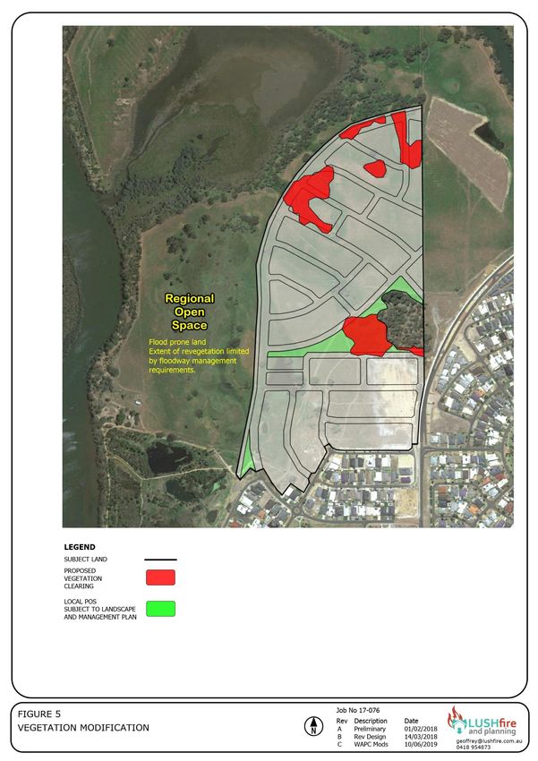
Parkridge Estate Eaton

                                       Document Reference
                                             Property Details

Street No         Lot No’s            Plan                Street Name
                  9004                404217             Peninsula Lakes Drive
                  9503                50198
                  9504                50198
Locality          Eaton                                    State WA              Postcode      6232
Local Government Area                 Dardanup

Description of the building           Residential subdivision
or works

                                               Report Details

 Revision          Date               Job No 17-076
 A                 29/01/2018         Preliminary
 B                 14/03/2018         Revised Structure Plan
 C                 25/06/2019         WAPC Modifications

                                           Practitioner Details

 BPAD              Level 2 Practitioner           Accreditation No               27682

                                                 Disclaimer
The measures contained in this report do not guarantee that a building will not be damaged in a bushfire.
The ultimate level of protection will be dependent upon the design and construction of the dwelling and the
level of fire preparedness and maintenance under taken by the landowner. The severity of a bushfire will
depend upon the vegetation fuel loadings; the prevailing weather conditions and the implementation of
appropriate fire management measures.

Geoffrey Lush
25 June 2019
geoffrey@lushfire.com.au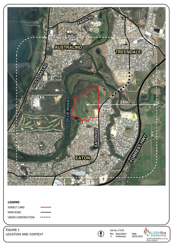
Parkridge Estate Eaton

                                                          CONTENTS

1.0 Proposal Details ........................................................................................................1
  1.1  Introduction .........................................................................................................1
  1.2  Existing Conditions ................................................................................................1
  1.3  Bushfire Prone Land ..............................................................................................4
  1.4  Fire Prevention Notice ...........................................................................................4
  1.5  Proposed Development .........................................................................................4
2.0 Environmental Considerations .....................................................................................7
  2.1  Native Vegetation Modification and Clearing ............................................................7
  2.2  Re-vegetation / Landscape Plans ............................................................................7
3.0 Bushfire Assessment Results ......................................................................................9
  3.1  Assessment Inputs ................................................................................................9
        3.1.1 Existing Vegetation Classifications ............................................................9
  3.2  Assessment Outputs ........................................................................................... 18
        3.2.1 BAL Contour Map .................................................................................. 18
4.0 Identification of Bushfire Hazard Issues ..................................................................... 23
  4.1  Locality .............................................................................................................. 23
  4.2  Local Open Space ............................................................................................... 23
5.0 Assessment Against the Bushfire Protection Criteria .................................................... 26
  5.1  Compliance Table ............................................................................................... 26
  5.2  Additional Management Strategies........................................................................ 29
        5.2.1 Purchaser Advice .................................................................................. 29
        5.2.2 Staging ................................................................................................ 29
6.0      Responsibilities for Implementation and Management of the Bushfire Measures ............ 30

                                                           FIGURES

Figure   1 Location and Context .............................................................................................. 2
Figure   2 Existing Conditions .................................................................................................. 3
Figure   3 Bushfire Prone Land ................................................................................................ 5
Figure   4 Structure Plan......................................................................................................... 6
Figure   5 Vegetation Modification ........................................................................................... 8
Figure   6 Vegetation Classifications ...................................................................................... 10
Figure   7 Modified Vegetation Classifications ......................................................................... 20
Figure   8 BAL Contour Map .................................................................................................. 21
Figure   9 BAL Cross Sections................................................................................................ 22
Figure   10 Bushfire Hazard Issues ........................................................................................ 25
Figure   11 Spatial Mitigation Measures .................................................................................. 28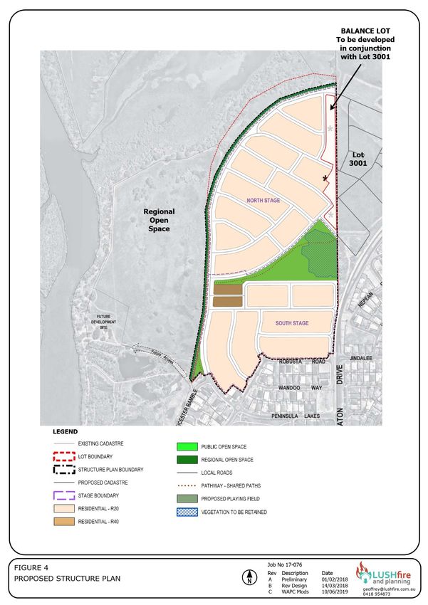
Parkridge Estate Eaton

                                                              TABLES

Table   1   Land Details ............................................................................................................ 1
Table   2   Existing Vegetation Classifications ............................................................................. 9
Table   3   Modified Vegetation Plots ....................................................................................... 18
Table   4   Lot BAL Classifications ............................................................................................ 19
Table   5   Bushfire Protection Criteria ..................................................................................... 26
Table   6   Implementation ..................................................................................................... 30

                                                           APPENDICES

Appendix 1....................................................................................................Floodway Advice
Parkridge Estate Eaton

1.0      PROPOSAL DETAILS
1.1      Introduction
This bushfire management plan is prepared for the proposed subdivision and development of the
Parkridge Estate located at Eaton.

The subject land is located approximately 8km east-north-east of the Bunbury CBD adjacent to
the Collie River as shown in Figure 1.

The aim of this Report is to reduce the likelihood and consequences of a bushfire within the
proposed development. The Report also demonstrates:
 1)     How the hazard level will be reduced and maintained for the life of the development. This
        will enable the decision-maker to ensure that appropriate bushfire risk management
        measures are in place to achieve and maintain a low or moderate hazard level.
 2)     That compliance with the Bushfire Protection Criteria in the Guidelines can be achieved.

1.2      Existing Conditions
The subject land has an area of 53 hectares and contains three lots as documented in Table 1.
It is irregular in shape with a depth varying between 600 and 880m with a width of approximately
880m.

The site has frontages to multiple roads including Leicester Ramble, Peninsula Lakes Drive,
Robusta Road and Eaton Drive. Lot 9504 is a battle axe lot with a 260m long access leg.

External access to the site is provided from Eaton Drive which connects to the Eaton district
centre and Forrest Highway. It is also in the process of being extended over the Collie River and
connecting into The Boulevard in Treendale.

The existing conditions are shown in Figure 2.

Table 1 Land Details
 Lot          Plan       Vol        Folio        Proprietor                        Area (ha)
 9004         404217     2880       400          Parkridge Group Pty Ltd            33.7650
 9503         50198      2632       554          Parkridge Group Pty Ltd            17.1610
 9504         50198      2632       555          Lancett Court Pty Ltd               2.2251
                                                                                    53.1511

The site is vacant and has been used for broad acre farming/grazing with improved pasture.
There are remains of several buildings and stock yards in Lot 9504.

The Collie River is situated on the western boundary and portions of the site are flood prone. The
land is gently undulating and slopes upwards towards Eaton Drive. Lot 9504 is more elevated
than the immediately surrounding area.

The land to the north is also vacant and contains a large wetland and freehold lot. Lot 3001 to
the east is vacant but designated for future residential development. The Millbridge residential
area is located to the east and Eaton to the south with regional open space areas along the river.

                                                                                                   1
Parkridge Estate Eaton

Figure 1 Location and Context

                                2
Parkridge Estate Eaton

Figure 2 Existing Conditions

                               3
Parkridge Estate Eaton
1.3 Bushfire Prone Land
Portions of the subject land are shown on the Map of Bush Fire Prone Areas (Figure 3) as being
bushfire prone. Bushfire prone areas are comprised of (1):
• Bushfire prone vegetation; and
• A 100m wide bushfire prone buffer.
The designation of bushfire prone areas triggers:
• The application of Australian Standard AS3959 Construction of Buildings in Bushfire Prone
Areas under the Building Code of Australia;
• The provisions of the Planning and Development (Local Planning Schemes) Amendment
Regulations 2015; and
• The application of SPP3.7 Planning in Bushfire Prone Areas.
1.4 Fire Prevention Notice
Council’s Fire Prevention Notice stipulates that in all residential zoned land that all flammable
material/vegetation (except living trees) must be slashed or grazed to a height that does not
exceed 50 millimetres and flammable material must be removed.
In the General Farming zone non irrigated lots are to have bare earth firebreaks of 2 metres width
and 4 metres in height which must be maintained within and adjacent to the lot boundary where
it adjoins a road and/or rail reserve.
1.5 Proposed Development
The proposed subdivision / development plan is shown in Figure 4 and the development portion
of the site is primarily located on the eastern portion of the site and also on lot 9504.
There are potentially three stages of development with an overall yield of 527 lots with a
combination of R20 and R40 densities.
• North stage - 316 lots; and
• South stage - 211 lots.
A local open space reserve being approximately 3.3 hectares will be provided centrally within the
Estate and a portion of this will retain the existing vegetation. The second area of local open
space will be provided around the River Stage lots and will function as a low fuel zone in
conjunction with the subdivision road. This reserve will be between 6 and 18m wide.
The north eastern portion of the development adjacent to the boundary of Lot 3001 will be left
as part of the balance lot pending the development of Lot 3001. This is because there will be
some common lots crossing the property boundary and is also allows this land to be used as an
asset protection zone pending completion of the final subdivision.
1 DFES (2015) Mapping Standard for Bush Fore Prone Areas.
4Parkridge Estate Eaton
Figure 3 Bushfire Prone Land
5Parkridge Estate Eaton
Figure 4 Structure Plan
6Parkridge Estate Eaton
2.0 ENVIRONMENTAL CONSIDERATIONS
2.1 Native Vegetation Modification and Clearing
Clearing within parts of the development area will occur for the construction of the subdivision as
shown in Figure 5.
2.2 Re-vegetation / Landscape Plans
The Local Open Space Areas is proposed to be developed and maintained as a managed reserve.
Except for the retained vegetation shown in Figure 4 the balance of the reserve will be landscaped
as Excluded Low Threat Vegetation. Further information regarding this is provided in Section 4.3.
The Regional Open Space is expected to be subject to a foreshore management plan which will
address and potential revegetation. The extent and nature of this revegetation and its
management have not been determined. However, this is likely to be restricted as the Regional
Open Space contains the active floodway for the Collie River. Advice from the Department of
Environment (2004) and The Department of Water (2011) is contained in Appendix 1 and
confirms that there cannot be any obstruction within the floodway.
At present time the majority of the Regional Open Space is improved pasture with some relatively
small areas of remnant trees as shown in Figures 2 and 6. Naturally occurring revegetation
especially from eucalyptus suckers, will be slow to occur due to the established grassland.
The proposed subdivision design includes a boundary road adjacent to the ROS that is 21m wide.
This will ensure that no matter vegetation is within the Regional Open Space the nearby lots will
still have a maximum BAL-29 rating as shown in Figures 8 and 9.
The central Local Open Space Area is proposed to be developed and managed as Low Threat
Vegetation by the Shire of Dardanup. This will be subject to the approval of a landscaping and
management plan.
7Parkridge Estate Eaton
Figure 5 Vegetation Modification
8Parkridge Estate Eaton
3.0 BUSHFIRE ASSESSMENT RESULTS
3.1 Assessment Inputs
3.1.1 Existing Vegetation Classifications
The classification of the vegetation on and adjacent to the site is shown in Figure 6 and the
photographs on the following pages. The classification is based upon AS3959 and also takes into
account The Visual Guide for Bushfire Risk Assessment in Western Australia (WAPC 2016). The
details of the vegetation plots are summarised in Table 2.
Table 2 Existing Vegetation Classifications
Slope
Plot Applied Vegetation Under
Comment
No Classification Vegetation
1 Excludable - 2.2.3.2(e) Non Flat Adjacent subdivision and residential
Vegetated Areas development. This includes the
managed public open space reserve
adjacent to the development.
2 Class A Forest - Low open Flat Wetland revegetation predominantly
forest A-04 Melaleuca
3 Excludable - 2.2.3.2(e) Non Flat Wetland with standing water.
Vegetated Areas
4 Class A Forest - Open forest Flat Eucalyptus revegetation on regional
A-03 open space
5 Class A Forest - Open forest 5 - 8 deg Linear vegetation along the riverbank
A-03 foreshore.
6 Class B Woodland - 0 - 3 deg Old homestead site with introduced
Woodland B-05 species.
7 Class B Woodland - 0 -5 deg Linear vegetation along the riverbank
Woodland B-05 foreshore. Will potentially become
forest.
8 Class A Forest - Open forest 0-5 deg Linear vegetation along the riverbank
A-03 and wetland foreshore areas.
9 Class G Grassland - Tussock Flat Wetland vegetation.
Moorland
10 Class B Woodland - Woodland 0-5 deg Woodland areas within the site with
B-05 grazed understorey.
11 Class G Grassland – Tussock 0-5 deg Grassland in adjacent land used for
grassland G-22 grazing.
12 Class A Forest - Open forest Upslope Peppermint and Eucalyptus forest
A-03 between 10 and 20m in height.
13 Class G Grassland – Sown Undulating Grassland, pasture within the
pasture G-26 development site.
9Parkridge Estate Eaton
Figure 6 Vegetation Classifications
10Parkridge Estate Eaton
Photo No 1 Plot No 1
Vegetation Classification
Excludable - 2.2.3.2(e) Non
Vegetated Areas
Description
Residential development adjacent
to the site.
Photo No 2 Plot No 1
Vegetation Classification
Excludable - 2.2.3.2(f) Low Threat
Vegetation
Description
Managed parkland POS adjacent to
the site
Photo No 3 Plot No 2
Vegetation Classification
Class A Forest - Low open forest A-
04
Description
Predominantly Melaleuca to 10m
with heavy understorey, grass and
some shrubland. Foliage cover
greater than 50%
11Parkridge Estate Eaton
Photo No 4 Plot No 3
Vegetation Classification
Excludable - 2.2.3.2(e) Non
Vegetated Areas
Description
Wetland adjacent to the site.
Photo No 5 Plot No 4
Vegetation Classification
Class A Forest - Open forest A-03
Description
Mixed species with predominantly
juvenile Eucalypts to 10m and will
be taller when mature. Dense
foliage and understorey with heavy
fuel load.
Photo No 6 Plot No 5
Vegetation Classification
Class A Forest - Open forest A-03
Description
Mixed species along the riverbank
with Melaleuca, Peppermints and
Eucalypts. Some open patches but
generally more than 30% foliage
coverage. Thick grass understorey,
scrub and heavy fuel loads greater
than 15tpa.
12Parkridge Estate Eaton
Photo No 7 Plot No 5
Vegetation Classification
Class A Forest - Open forest A-03
Description
Mixed species along the riverbank
with Melaleuca, Peppermints and
Eucalypts. Some open patches but
generally more than 30% foliage
coverage. Thick grass understorey,
scrub and heavy fuel loads greater
than 15tpa.
Photo No 8 Plot No 6
Vegetation Classification
Class B Woodland - Woodland B-05
Description
Mixed introduced species and
some native around the old
homestead site.
Photo No 9 Plot No 7
Vegetation Classification
Class B Woodland - Woodland B-05
Description
Mixed species, Eucalypts and Acacia
with less than 30% foliage
coverage and open understorey
predominantly grassland with
moderate fuel load.
With revegetation this area is likely
to continue to regenerate as forest.
13Parkridge Estate Eaton
Photo No 10 Plot No 7
Vegetation Classification
Class B Woodland - Woodland B-05
Description
Mixed species, Eucalypts and
Acacia with less than 30% foliage
coverage and open understorey
predominantly grassland with
moderate fuel load.
With revegetation this area is likely
to continue to regenerate as forest.
Photo No 11 Plot No 8
Vegetation Classification
Class A Forest - Open forest A-03
Description
Revegetation along foreshore area.
Mixed vegetation being Eucalypts
on elevated areas and Melaleuca in
the lower areas. Heavy grass
understorey.
Photo No 12 Plot No 8
Vegetation Classification
Class A Forest - Open forest A-03
Description
Eucalypts on the foreshore slope.
Trees to 18m height with more than
30% foliage coverage. Heavy
grass understorey with fallen
timber.
14Parkridge Estate Eaton
Photo No 13 Plot No 8
Vegetation Classification
Class A Forest - Low open forest A-
04
Description
Eucalypts on the foreshore slope.
Trees to 18m height with more
than 30% foliage coverage. Heavy
grass understorey with fallen
timber.
Photo No 14 Plot No 8
Vegetation Classification
Class A Forest - Open forest A-03
Description
Eucalypts on the foreshore slope.
Trees to 18m height with more than
30% foliage coverage. Heavy
grass understorey with fallen
timber.
Photo No 15 Plot No 9
Vegetation Classification
Class G Grassland - Tussock
Moorland
Description
Tussock grassland to 0.75m
associated with the wetland areas
15Parkridge Estate Eaton
Photo No 16 Plot No 10
Vegetation Classification
Class B Woodland - Woodland B-05
Description
Woodland areas associated with
grazing land. Trees to 18m height
with less than 30% foliage
coverage, open canopy and
understorey.
Photo No 17 Plot No 11
Vegetation Classification
Class G Grassland – Tussock
grassland G-22
Description
Unmanaged grassland previously
used for grazing adjacent to the
site.
Photo No 18 Plot No 11
Vegetation Classification
Class G Grassland – Tussock
grassland G-22
Description
Unmanaged grassland previously
used for grazing adjacent to the
site.
16Parkridge Estate Eaton
Photo No 19 Plot No 12
Vegetation Classification
Class A Forest - Open forest A-03
Description
Mixed Eucalypts and Peppermints
to 20m in height with foliage
coverage of 60%. Peppermints
have continuous foliage from
ground. Some scrub understorey
but generally heavy weeds and fuel
loads.
Photo No 20 Plot No 12
Vegetation Classification
Class A Forest - Open forest A-03
Description
Mixed Eucalypts and Peppermints
to 20m in height with foliage
coverage of 60%. Peppermints
have continuous foliage from
ground. Some scrub understorey
but generally heavy weeds and fuel
loads.
Photo No 20 Plot No 13
Vegetation Classification
Class G Grassland – Sown pasture
G-26
Description
Grazing land within the site,
pasture less than 300mm.
17Parkridge Estate Eaton
3.2 Assessment Outputs
3.2.1 BAL Contour Map
Figure 7 shows the proposed modified vegetation plots with the associated vegetation plots being
documented in Table 3. The modifications include a 3m wide firebreak being located on the
boundary of the Regional Open Space.
A BAL Contour Map is shown in Figure 8 and this is a plan of the subject lot/s illustrating the
potential radiant heat impacts and associated indicative BAL ratings in reference to any classified
vegetation remaining within 100 metres of the assessment area after the development is
completed.
Figure 9 shows the proposed cross sections and associated BAL setbacks for each major
development interface.
Table 3 Modified Vegetation Plots
Effective
Plot Applied Vegetation
Slope Comment
No Classification
A Managed land Flat & Adjacent subdivision and residential
Upslope development.
B Class G Grassland Flat & Grassland area associated with tracks and
Upslope cleared portions of the foreshore reserve.
C Class A Forest Flat Predominantly Melaleuca to 10m with heavy
understorey, grass and some shrubland.
D Class G Grassland >0-5 Grassland, pasture within the Regional Open
Space. Any revegetation is likely to be restricted
as this is the active floodway for the Collie River.
E Class B Woodland >0-5 Woodland areas within the site with grazed
understorey.
F Class A Forest >0-5 Trees to 18m height with more than 30%
foliage coverage.
G Class B Woodland >0-5 Woodland areas within the site with grazed
understorey.
H Class G Grassland >0-5 Grassland in adjacent vacant undeveloped land
used for grazing.
I Class A Forest Upslope Peppermint and Eucalyptus forest between 10
and 20m in height.
J Managed land >0 - 5 Developed parkland to be managed by the
Council.
18Parkridge Estate Eaton
The BAL ratings for the individual lots are documented in Table 4. As there is no detailed lot
design the subdivision has been divided into residential cells based upon the proposed road
network. It is also noted that Cell 11 is part of the balance lot which will be the final stage and
developed in conjunction with the adjacent Lot 3001.
Cells 1 & 4 have a 3m encroachment of BAL-40 which corresponds to the minimum development
setback. This would also apply to any of the cells adjacent to the Regional Open Space where
any revegetation might occur and is classified as Class A Forest; notwithstanding the presumption
against revegetation obstructing the floodway.
Table 4 Lot BAL Classifications
Cell Plot No Vegetation Effective Separation BAL BAL 29
Number (1) Classification Slope Distance Rating at Setback
(Face) (2) Boundary (3)
1 (N) F A Forest >0-5m 24m BAL-40 3m
2 (W) F A Forest >0-5m 30m BAL-29
3 (W) F A Forest >0-5m 27m BAL-29
4 (W) F A Forest >0-5m 24m BAL-40 3m
5 (NW) F A Forest >0-5m 27m BAL-19
6 (W) D G Grassland >0-5m 27m BAL-12.5
7 (W) D G Grassland >0-5m 27m BAL-12.5
8 (W) D G Grassland >0-5m 27m BAL-12.5
9 (W) D G Grassland >0-5m 27m BAL-12.5
10 (W) D G Grassland >0-5m 27m BAL-12.5
11 Part of the balance lot acting as low fuel zone.
12 (E) E G Grassland Upslope 12m BAL-19
13 (E) E G Grassland Upslope 17m BAL-12.5
14 (SE) I A Forest Upslope 21m BAL-29
15 (NE) I A Forest Upslope 80m BAL-12.5
16 (NE) E G Grassland >0-5m >100m BAL-Low
17 (W) I A Forest Upslope 25m BAL-29
18 (NE) H G Grassland Upslope 26m BAL-12.5
19 (NW) H G Grassland Upslope >50m BAL-Low
Notes
(1) The selected vegetation plot is the plot with the highest BAL rating.
(2) The separation distance is measured to the nearest point on the lot boundary.
(3) Refers to the setback within the relevant cell where a BAL-29
19Parkridge Estate Eaton
Figure 7 Modified Vegetation Classifications
20Parkridge Estate Eaton
Figure 8 BAL Contour Map
21Parkridge Estate Eaton
Figure 9 BAL Cross Sections
22Parkridge Estate Eaton
4.0 IDENTIFICATION OF BUSHFIRE HAZARD ISSUES
4.1 Locality
Figure 1 shows the existing conditions for the locality around the subject land. The most
significant bushfire hazard will be the Regional Open Space. The proposed road network and the
bridge over the Collie River provide excellent district access in multiple directions.
The bushfire hazard issues are shown in Figure 10 and the issue numbers are referenced as
follows:
1. Development interface with the Regional Open Space. There is a presumption against any
substantial revegetation which might affect the function of the floodway. It is unknown if
this would prevent small areas of vegetation, of any classification, occurring in selected areas.
Even if these are less than 2,500sqm in size they would still be classified where they adjoin
the balance of the grassland vegetation in the balance of the ROS. This interface will be
managed by providing an 21m wide boundary subdivision road, noting that there will also be
a 3m boundary firebreak within the POS.
2. Grassland interface with Lot 3001. This affects the north eastern portion of the site and once
Lot 3001 is developed then there not be any adjacent vegetation hazard. At present there is
grassland vegetation on Lot 3001 and the setback for a BAL-29 rating of the lots is 8m. This
interface will be managed by leaving this area as part of the balance lot pending the
development of Lot 3001. This area will then be maintained as an asset protection zone so
that no portion of the adjoining lots have a BAL-40 or BAL-FZ rating.
3. The proposed local open space will contain an area of remnant vegetation. As this is greater
than 1 hectare in size it is classified as being a bushfire hazard. The management plan for
the reserve will include some minor clearing to ensure that there are appropriate development
setbacks.
4. Eaton Drive provides district road access in two different directions. The bridge over the
Collie River links into The Boulevard in the Treendale Estate.
5. The principal local access to the subject land is from Peninsula Lakes Drive with secondary
access from Leichester Ramble.
6. There is restricted access to Eaton Drive from Robusta Road the area north of this.
7. In order to provide two access roads, it will be necessary to have a temporary emergency
access way connecting through Lot 3001 to Eaton Drive pending the development of Lot
3001.
4.2 Local Open Space
As indicated in Section 2.2 the Local Open Space Area reserve is proposed to be partially
developed and managed as low threat vegetation by the Shire of Dardanup.
This would be subject to a landscaping plan approved by Council with the landscaping established
by the developer and maintained for two years as prescribed by Model Subdivision Condition R4
which states that:
Arrangements being made for the proposed public open space to be developed
by the landowner/ applicant to a minimum standard and maintained for two
summers through the implementation of an approved landscape plan providing
for the development and maintenance of the proposed public open space in
accordance with the requirements of Liveable Neighbourhoods and to the
specifications of the local government. (Local Government)
This condition is imposed in accordance with the requirements of Liveable Neighbourhoods
Element 4. It is further reinforced in Section 6.3.3.2 of the Local Government Guidelines for
23Parkridge Estate Eaton
Subdivisional Development (2) which set out the standard requirements for the development of
public open space including:
a) The preparation of a management plan;
b) A long-term maintenance agreement based on the management plan being entered into
by the developer with the Local Government as part of the approval.
c) A landscape maintenance and watering period of at least two summer periods to ensure
full establishment, which includes a maintenance bond.
Further justification of this assumption can be provided by including the approval of the landscape
and maintenance plans by Council as part of the requirements for clearance of the subdivision
conditions associated with this bushfire management plan.
2 Department of Planning Lands and Heritage (2017) Local Government Guidelines for
Subdivisional Development
24Parkridge Estate Eaton
Figure 10 Bushfire Hazard Issues
25Parkridge Estate Eaton
5.0 ASSESSMENT AGAINST THE BUSHFIRE PROTECTION
CRITERIA
5.1 Compliance Table
In formulating the proposed mitigation measures regard has been given to the objectives, general
principles, guidance statements and performance criteria contained in the Guidelines for Planning
in Bushfire Prone Areas and specifically the Bushfire Protection Criteria. The requirements in the
Bushfire Protection Criteria and the proposed mitigation strategies are summarised in Table 4 and
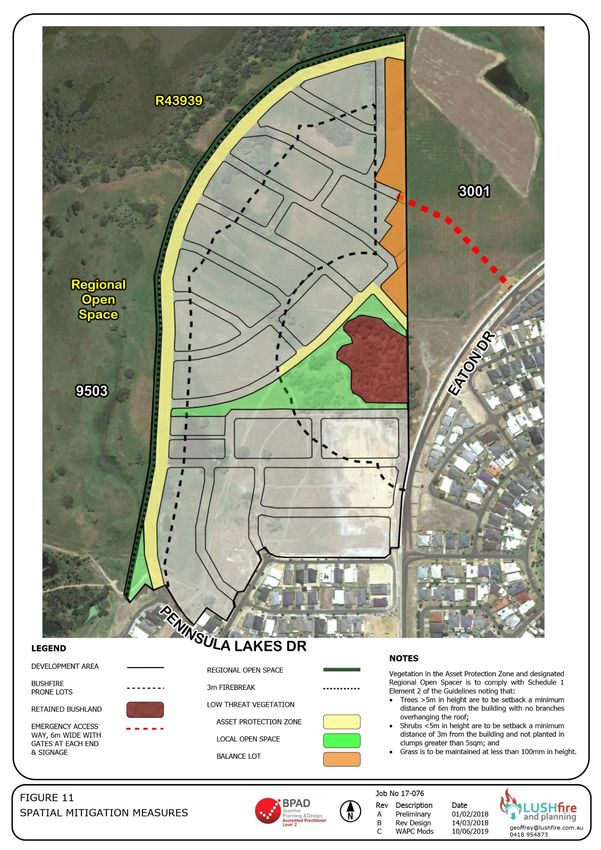
shown spatially in Figure 11.
Table 5 Bushfire Protection Criteria
Bushfire Method of Compliance Compliance Proposed bushfire management strategies
protection Acceptable solutions /
criteria Performance based
solution
Element 1: A1.1 Development Yes The proposed lots will have a BAL-29 or lower
Location location rating. This is subject to lots opposite the ROS
having a 3m front development setback. This
will be reinforced by the use of a restrictive
covenant to prevent development within any
area with a BAL-40/FZ rating.
Based upon the existing vegetation this will only
apply to Cells 1 and 4. It may apply to other
cells in the event of any revegetation being
classified as Forest.
Element 2: A2.1 Asset protection Yes The lots are not large enough to contain the
Siting and zone (APZ) APZ within their own boundaries. Generally, for
design the “first row” of dwellings adjacent to the
hazard areas the APZ will be provided within the
development setback from the front boundary
combined with the 18m wide road reserve and
in some instance portions of the Local Open
Space.
This complies with the Guidelines which state
on page 63 of the BPC that the APZ may include
public roads, waterways, footpaths, buildings,
rocky outcrops, golf courses, maintained
parkland as well as cultivated gardens in an
urban context.
Element 3: A3.1 Two access routes Yes A temporary access connection to Eaton Drive
Vehicular will be required.
access A3.2 Public road Yes The subdivision roads will be constructed in
accordance with the Local Government
Guidelines (3) for Subdivisional Development
3 Department of Planning Lands and Heritage (2017) Local Government Guidelines for
Subdivisional Development
26Parkridge Estate Eaton
Bushfire Method of Compliance Compliance Proposed bushfire management strategies
protection Acceptable solutions /
criteria Performance based
solution
which meet required specifications for bushfire
access.
A3.3 Cul-de-sac N/A There are no cul-de-sacs in the development.
(including a dead-end-
road)
A3.4 Battle-axe N/A There are no battle axe lots.
A3.5 Private driveway N/A There are no lots more than 50m deep.
longer than 50m is to
meet detailed
requirements contained
within the Guidelines.
A3.6 Emergency access Yes The proposed EAW will be approximately 200m
way (EAW) in length and located on the alignment of a
future subdivision road. The agreement of the
owner of Lot 3001.
A3.7 Fire service access N/A There are no proposed FSARs
routes (FSAR)
A3.8 Firebreak width N/A All lots are less than 0.5ha in size.
Element 4: A4.1 Reticulated areas Yes The subdivision will be serviced with fire hydrants
Water in accordance with the required specification. A
plan of the hydrants will be submitted to Council
and DFES as part of the subdivision clearance.
A4.2 Non-reticulated N/A Not applicable
areas
A4.3 Individual lots Yes Not applicable
within non-reticulated
areas.
27Parkridge Estate Eaton
Figure 11 Spatial Mitigation Measures
28Parkridge Estate Eaton
5.2 Additional Management Strategies
5.2.1 Purchaser Advice
All prospective purchasers must be made aware of the fire management issues, measures and
responsibilities associated with the subdivision. This can be a notification placed upon the
Certificate of Title of all lots pursuant to Section 70A of the Transfer of Land Act advising
landowners of this Bushfire Management Plan and BAL requirements.
5.2.2 Staging
The development of the estate will have staged construction. In the event that the subdivision
is staged then it is necessary to ensure that appropriate interim measures are provided. These
may include:
• Interim access or emergency access ways;
• Creation of additional low fuel zones to ensure that the intended BAL ratings can be
applied; or
• The provision of boundary firebreaks especially on any balance lot.
For any proposed stage of the subdivision a statement and plan of the proposed interim fire
management measures will be submitted and approved by the Shire as an adjunct to Figure 11.
29Parkridge Estate Eaton
6.0 RESPONSIBILITIES FOR IMPLEMENTATION AND
MANAGEMENT OF THE BUSHFIRE MEASURES
The management of the risk posed by bushfires is a shared responsibility between landowners,
government and industry. These responsibilities are summarised in Table 6.
Table 6 Implementation
No MANAGEMENT ACTION TIMING
1.0 Developer Prior to Issue of Titles
1.1 Construction of subdivision roads to standards outlined in the BMP to ensure Subdivision
safe access and egress.
1.2 A restrictive covenant to the benefit of the local government, pursuant to Subdivision
section 129BA of the Transfer of Land Act 1893, is to be placed on the
certificate(s) of title of the proposed lot(s) advising of the existence of a
restriction on the use of the land within areas that have been assessed as BAL-
40 or BAL-Flame Zone.
1.3 Maintaining the balance area Cell 11 as low threat vegetation pending the Subdivision
development of Lot 3001.
1.4 Obtaining the agreement of the owner of Lot 3001 for the proposed emergency Subdivision
access way.
1.5 Construction of the emergency access way with associated gates and signage. Subdivision
1.6 A plan demonstrating the location and capacity of fire the fire hydrants shall be Subdivision
submitted to the Shire of Dardanup and DFES.
1.7 Preparation and approval of the landscape and maintenance plans by Council Subdivision
for the areas of Local Open Space. These are to address the proposed
vegetation modification, separation areas, fuel loads and weed management
and specifications contained in Schedule 1 Standards for Asset Protection
Zones.
1.8 Preparing a notification be included on the certificate of titles for the lots shown Subdivision
on Figure 11 as being bushfire prone advising that the land is subject to a
Bushfire Management Plan.
2.0 Developer Prior to Sale
2.1 Providing prospective residents with a summary of this BMP.
3.0 Landowner Prior to Occupancy
3.1 Ensuring that any application for a building permit for a dwelling is to include Development
an individual BAL assessment to confirm that sufficient land has been cleared to
provide for BAL-29 setbacks.
4.0 Landowners Ongoing
4.1 Undertaking regular maintenance of their property in preparation for the annual Ongoing
fire season.
4.2 Ensuring that all fire mitigation measures shall be completed by the date Ongoing
prescribed in Council’s Firebreak Order.
30Parkridge Estate Eaton
5.0 Local Government Ongoing Management
5.1 Ensuring Building Permit Applications and Development Applications are Ongoing
compliant with the building and land use planning provisions.
5.2 Maintenance of the designated areas of Local Open Space as low threat Ongoing
vegetation in accordance with the approved management plans.
5.3 Enforce compliance with its annual firebreak notice. Ongoing
6.0 Lot 9503
6.1 Provision and maintenance of the 3.0m boundary firebreak Ongoing
31Parkridge Estate Eaton
Appendix 1 Floodway Advice
32You can also read