ASSESSMENT OF URBAN TRANSPORT AND IMPACTS OF COVID-19 ON MOBILITY FOR PHNOM PENH CITY - Prepared by Chea Monykoran
←
→
Page content transcription
If your browser does not render page correctly, please read the page content below
ASSESSMENT OF URBAN TRANSPORT AND
 IMPACTS OF COVID-19 ON MOBILITY FOR
          PHNOM PENH CITY

         Prepared by Chea Monykoran
    Deputy Director, Land Transport Department,
                 MPWT, Cambodia
                  December 2021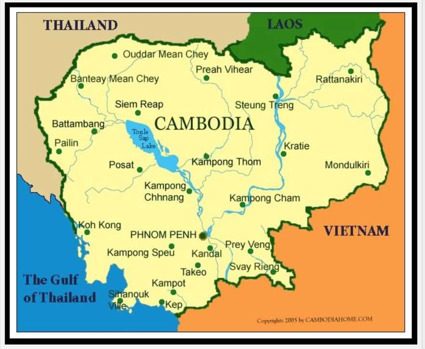
xxx

                                     xx

Disclaimer:

The views expressed in this publication are those of the authors and do not
necessarily reflect the views of the United Nations Economic and Social Commission
of Asia and the Pacific (ESCAP). The designation employed and the presentation of
the material in the report do not imply the expression of any opinion whatsoever on
the part of the Secretariat of the United Nations concerning the legal status of any
country, territory, city, or area or of its authorities, or concerning the delimitation of its
frontiers or boundaries. The views expressed, analysis, conclusions and
recommendations are those of the authors, and should not necessarily be
considered as reflecting the views or carrying the endorsement of the United
Nations. Mention of firm names and commercial products does not imply the
endorsement of the United Nations ESCAP.

This report has been issued without formal editing.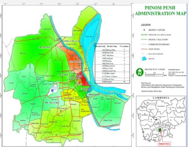
ACKNOWLEDGEMENTS

        Many individuals have helped me make this report possible in a variety of
ways during the study. At UNESCAP, those assisting me include Dr. Madan B.
Regmi, Economic Affairs Officer of Transport Research and Policy Section, Ms.
Wanna Kunsabfueng, Staff Assistant of Transport Research and Policy Section, and
others. At the General Department of Land Transport (GDLT), MPWT, H.E Chhoun
Voun, Director General, Mr. Duy Chan Dara, Deputy Director General, Ms. Men
Chan Sokol, Director of Land Transport Department (LTD), Mr. Meng Chhunheng,
Director of Urban Public Transport Department, the staff at Urban Public Transport
Department and Road Traffic Safety Department, and my team members. Besides,
the people also assisting me include Mr. Ean Sokhim, the governor of City Bus
Authority (CBA) and all his staff, Dr. Kok Sothea, lecturer at RUPP, and many others
from various organizations. Without their tireless cooperation, timeless assistance,
and constant encouragement, the present assessment report would not have been
achieved. In response to their generous contribution, my acknowledgements go
generally and particularly as follows:
        I would, first, like to thank UNESCAP for granting me the opportunity to get
involved in such crucial development work as the national consultant for the project
of Sustainable Assessment of Urban Mobility and Impacts of COVID-19 on
Passenger Transport from June to December 2021. This occasion does not only give
me a chance for my professional development, but also gives both direct and indirect
benefits for GDLT of MPWT, especially in the field of Public Urban Transport System
Development in Cambodia, and Phnom Penh in particular, through the forthcoming
evidence-based strategic plan and policy formulation and project interventions
derived from the present report. I should also like to express my thankfulness and
appreciation for DGLT and LTD, for purveying me to pursue the present paper.
      My special indebtedness and profound thankfulness go to my immediate
leaders namely H.E Chhoun Voun, Director General of GDLT; and Ms. Men Chan
Sokol, Director of LTD, who have always been helpful to me with their
encouragements, guidance, invaluable advice, duty discharges on several occasions
during the entire process of drafting this report. In addition to this, their
approachability has relieved my anxiety, tension and frustration of performance while
pursuing this assessment. Without their tireless assistance and efforts, the conduct of
this study process would have been extremely difficult.
      I would, secondly, like to acknowledge my deep and sincere gratitude to my
project manager, Dr. Madan B. Regmi, Economic Affairs Officer of Transport
Research and Policy Section, for his insightful comments, positive encouragements,
continuing advice, and kind understanding. I should, thirdly, also like to thank Ms.
Wanna Kunsabfueng, Staff Assistant of Transport Research and Policy Section of

                                           ii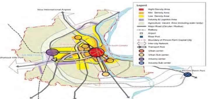
UNDESCAP for excellent administrative works, coordination, and assistance.
Fourthly, I would also like to express my gratitude and thanks to Mr. Meng
Chhunheng, Director of Urban Public Transport Department, Mr. Ean Sokhim, CBA
Governor and his associates for sharing experiences, ideas, information, that were
interesting, useful, and invaluable as well as their warmest hospitality during the
interview meeting. Great thanks and appreciations are due to my teams, Mr. Y Song,
project focal point, Mr. Kak Yuthavonn, coordinator, and Mr. Kim Panhaseth,
coordinator. Certainly, their kind, helpful attitudes encourage me to perform the best.

                                           iii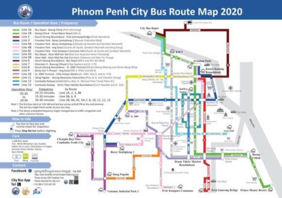
TABLE OF CONTENTS
ACKNOWLEDGEMENTS .......................................................................................... ii
TABLE OF CONTENTS ............................................................................................ iv
LIST OF TABLES ...................................................................................................... v
LIST OF FIGURES .................................................................................................... vi
CHAPTER 1 INTRODUCTION ................................................................................... 1
 1.1    Overview of Phnom Penh ............................................................................. 1
 1.2    Phnom Penh Master Plans ........................................................................... 7
   1.2.1 Phnom Penh Master Plan on Land Use 2035 ............................................ 7
   1.2.2 Phnom Penh Urban Transport Master Plan 2014-2035............................ 10
   1.2.3 Phnom Penh Sustainable City Plan 2018-2030 ........................................ 11
 1.3    Study objectives ......................................................................................... 12
 1.4    Project Area ............................................................................................... 13
 1.5    Assessment Framework ............................................................................. 13
CHAPTER 2 URBAN STRUCTURES, TRANSPORT INFRASTRUCTURE, AND
LAND TRANSPORT ................................................................................................ 14
  2.1    Urban Structures ........................................................................................ 14
    2.1.1 Land Use and Urbanization in Phnom Penh ........................................... 14
    2.1.2 Future Structure of Phnom Penh Capital City ........................................... 15
  2.2    Transport Infrastructures ............................................................................ 19
    2.2.1 Urban Road Network Systems................................................................ 19
    2.2.2 Ring Roads ............................................................................................. 21
    2.2.3 Bridges ................................................................................................... 22
    2.2.4 Sidewalks ............................................................................................... 23
    2.2.5 Parking ................................................................................................... 23
  2.3 LAND TRANSPORT ....................................................................................... 24
    2.3.1. National Road Safety Committee (NRSC) ............................................... 24
    2.3.2. Present State of Vehicle Registration ...................................................... 25
    2.3.3 Urban Public Transport in Phnom Penh ................................................... 25
    2.3.4 Evolution of Public Bus Service in Phnom Penh ...................................... 26
    2.3.5 Current Situation of City Bus .................................................................... 27
    2.3.6 Difficulties and Challenges ....................................................................... 28
    2.3.7 Public Bus Corridors ................................................................................. 29
CHAPTER 3 DATA COLLECTION, DERIVATION AND ANALYSIS FOR THE SUTI
FRAMEWORK ......................................................................................................... 30
  3.1 The Structure of SUTI Framework .................................................................. 30
  3.2 Data Collection and Derivation ........................................................................ 30
  3.3 SUTI Result..................................................................................................... 47

                                                           iv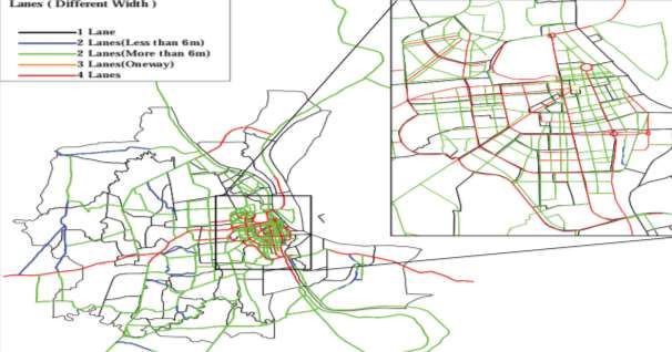
CHAPTER 4 SUTI RESULTS AND INTERPRETATIONS ....................................... 49
 4.1 SUTI Scores and Interpretations ..................................................................... 49
 4.2 Perspectives on SUTI framework .................................................................... 51
CHAPTER 5 CONCLUSIONS, IMPLICATIONS AND POSSIBLE MEASURES ..... 52
 5.1 Conclusions and Implications .......................................................................... 52
 5.2 Suggestions and Measures to be taken .......................................................... 53
CHAPTER 6 GENDER, RENEWABLE ENERGY AND IMPACTS OF COVID-19... 54
 6.1 Gender and inclusiveness in Phnom Penh city public transport ...................... 54
 6.2 Renewable Energy .......................................................................................... 55
 6.3 Impacts of COVID-19 ...................................................................................... 55
   6.3.1 General Situation of COVID-19 in Cambodia ........................................... 55
   6.3.2 Public health response measures by the government and authorities...... 56
   6.3.3 Number of Covid-19 cases and death in Cambodia ................................. 56
   6.3.4 Number of Vaccinated Cambodians ......................................................... 57
 6.4 Phnom Penh Public Bus Conditions before and after COVID-19 .................... 57
   6.4.1 The general Situation of Phnom Penh City Bus before COVID-19 outbreak
    .......................................................................................................................... 57
   6.4.2 City Bus Ridership before Covid-19 outbreak ........................................... 59
   6.4.3 COVID-19 Impacts and responsive measures on Public Transport in
   Phnom Penh...................................................................................................... 60
REFERENCES ......................................................................................................... 62

                                               LIST OF TABLES

Table 1 List of Administrative Sections and Population of Phnom Penh Metropolitan 3
Table 2 Phnom Penh Population Projection by year .................................................. 5
Table 3 Strategies for the Plan 2035 .......................................................................... 7
Table 4 Prioritized actions under the Phnom Penh Master Plan on Land Use 2035 .. 8
Table 5 Proposed Phnom Penh Urban Transport Master Plan 2035 ........................ 10
Table 6 The framework of 10 SUTI indicators .......................................................... 13
Table 7 The objectives and action plans of NRSC ................................................... 24
Table 8 The number of registered vehicles in 2020 in Phnom Penh ........................ 25
Table 9 The 10 Sustainable Urban Transport Indicators .......................................... 30
Table 10 Scoring for Indicator 1................................................................................ 32
Table 11 Final derived value for Indicator 1 .............................................................. 32
Table 12 Travel modes ............................................................................................. 33
Table 13 Mode share of active and public transport in commuting ........................... 34
Table 14 Final value of indicator 2 ............................................................................ 35
Table 15 The value of indicator 3 ............................................................................. 35

                                                               v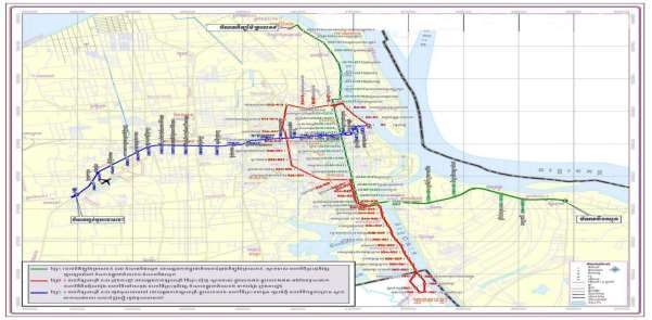
Table 16 Final Value for Indicator 3 .......................................................................... 35
Table 17 User perception survey .............................................................................. 36
Table 18 Results of public perception and customer satisfaction ............................. 37
Table 19 Final Score for Indicator 4 .......................................................................... 38
Table 20 The number of casualties by transport type and year ................................ 38
Table 21 The data of traffic accidents in Phnom Penh in 2018 and 2019 ................. 39
Table 22 Final value of indicator 5 ............................................................................ 40
Table 23 Cost of public transportation in 2019 ......................................................... 40
Table 24 Final value of indicator 6 ............................................................................ 41
Table 25 Fare box ratio - indicator 7 ......................................................................... 41
Table 26 Final Value for Indicator 7 .......................................................................... 42
Table 27 Annual investment for public transport facilities in Phnom Penh ............... 42
Table 28 Final value for indicator 8........................................................................... 43
Table 29 Annual mean of PM2.5 in 2019 ................................................................. 44
Table 30 Final value for indicator 9........................................................................... 45
Table 31 Final value for indicator 10 ......................................................................... 46
Table 32 The SUTI Score for Phnom Penh capital city ............................................ 47
Table 33 The SUTI Score for Phnom Penh capital city ............................................ 49
Table 34 The number of Covid-19 test, cases, and death in Cambodia ................... 56
Table 35 The number of vaccinated Cambodians .................................................... 57
Table 36 The number of vaccinated Cambodians according to age categories ....... 57
Table 37 Disinfection of Vehicle during COVID-19 ................................................... 59

                                              LIST OF FIGURES

Figure 1 Map of Cambodia and Location of Phnom Penh .......................................... 1
Figure 2 Phnom Penh Metropolitan Area ................................................................... 2
Figure 3 Breakdown of Population by Khan/District .................................................... 4
Figure 4 Population Projection of Phnom Penh .......................................................... 6
Figure 5 Cambodia National GDP Growth Rate ......................................................... 7
Figure 6 Development Visions for Phnom Penh ....................................................... 12
Figure 7 Phnom Penh Urbanization Directions ......................................................... 14
Figure 8 Current Urbanization Directions and Ring Roads ....................................... 15
Figure 9 Urban Structure in 2020 ............................................................................. 16
Figure 10 Urban Structure in 2035 ........................................................................... 19
Figure 11 Road Network of Phnom Penh City .......................................................... 20
Figure 12 The road networks in the inner districts (left) and in the suburban districts
(right). Red dots represent the notes and cul-de-sacs, and the light green represents
the edges (UNDP, 2021) .......................................................................................... 21
Figure 13 The Development Plan of Ring Roads in Phnom Penh (JICA-PPUTMP,
2035) ........................................................................................................................ 22

                                                               vi
Figure 14 The connection between Phnom Penh and surrounding areas via brides 22
Figure 15 Vendors’ tables and chairs line the sidewalk on Phnom Penh’s Preah
Sihanouk Blvd........................................................................................................... 23
Figure 16 Underground Parking Lot on Phnom Penh’s Monivong Blvd .................... 24
Figure 17 Phnom Penh Bus Route Map 2020 .......................................................... 27
Figure 18 Official Apps and Fare Collecting System for City Bus in Phnom Penh .... 27
Figure 19 Air Quality (PM2.5) at all 13 Monitoring Stations in Phnom Penh in 2019 44
Figure 20 Spider diagram for Phnom Penh .............................................................. 48
Figure 21 The performance of Phnom Penh public transport system in spider
diagram..................................................................................................................... 51
Figure 22 The map of 3 bus routes, using 57 buses from 2014-2017 ...................... 58
Figure 23 The map of 8 bus routes, using 155 buses from 2017-2018 .................... 58
Figure 24 The map of 13 bus routes, using 235 buses from 2018-2020 (before
COVID-19) ................................................................................................................ 59
Figure 25 The Project for Improvement of Public Bus Operation in Phnom Penh
(PiBO) ....................................................................................................................... 61

                                                               vii
ASSESSMENT OF URBAN TRANSPORT AND IMPACTS OF COVID-19 ON MOBILITY FOR PHNOM PENH CITY

                          CHAPTER 1 INTRODUCTION

1.1    Overview of Phnom Penh
Phnom Penh
       Phnom Penh is the capital and most populous city in Cambodia. It has been the
national capital since French colonization of Cambodia, and has grown to become the
nation's economic, industrial, and cultural center. Situated on the banks of the Tonle
Sap, Mekong, and Bassac Rivers, Phnom Penh is home to more than 2 million people,
approximately 14% of the Cambodian population (PPCA Annual Report, 2020).

Figure 1 Map of Cambodia and Location of Phnom Penh

Source: Cambodiahom.com

                                              1
ASSESSMENT OF URBAN TRANSPORT AND IMPACTS OF COVID-19 ON MOBILITY FOR PHNOM PENH CITY

Geography
       Phnom Penh is in the south-central region of Cambodia, and is fully surrounded
by Kandal Province. The municipality is on the banks of the Tonlé Sap, Mekong,
and Bassac Rivers. These rivers provide freshwater and other natural resources to the
city. Phnom Penh and the surrounding areas consist of a typical flood plain area for
Cambodia. Although Phnom Penh is at 11.89 metres above the river, monsoon season
flooding is a problem, and the river sometimes overflows its banks. The city, at 11.55°N
104.91667°E (11°33' North, 104°55' East), covers an area of 679 square kilometres
with some 11,401 hectares in the municipality (central urban area) and 26,106 ha of
roads. The agricultural land in the municipality amounts to 34.685 km2 with some
1.476 km2 under irrigation (PPCA, 2020).

Figure 2 Phnom Penh Metropolitan Area

Source: Phnom Penh Capital Administration (PPCA), 2020

Climate
       Phnom Penh has a tropical wet and dry climate. The climate is hot year-round
with only minor variations. Temperatures typically range from 22 to 35 °C (72 to 95 °F)
and weather is subject to the tropical monsoons. The southwest monsoon blows inland
                                              2
ASSESSMENT OF URBAN TRANSPORT AND IMPACTS OF COVID-19 ON MOBILITY FOR PHNOM PENH CITY
bringing moisture-laden winds from the Gulf of Thailand and Indian Ocean from May
to November. The northeast monsoon ushers in the dry season, which lasts from
December to April. The city has two distinct seasons like the entire Cambodia. The
rainy season, which runs from May to November, sees high temperatures
accompanied by high humidity. The dry season lasts from December to April, when
overnight temperatures can drop to 22 °C (72 °F).
Administration
Phnom Penh is a municipality of 679 square-kilometre area with a government
status equal to that of Cambodia’s provinces. The municipality is divided into 14
administrative divisions called khans (districts). The Khans (districts) are sub-divided
into 105 sangkats (quarters), and further sub-divided into
953 phums (villages). All Khans (districts) are under the governance of the Phnom
Penh Municipality. Dangkao, Meanchey, Porsenchey, Sen Sok and Russei Keo are
considered the outskirts of the city.
The municipality is governed by the governor (mayor) who acts as the top
executive of the city as well as overseeing the Municipal Military Police, Municipal
Police, and Bureau of Urban Affairs. Below the governor is the vice governors. The
chief of cabinet heads the cabinet consisting of deputy chiefs of cabinet who in turn
are in charge of the 27 administrative departments. Every khan (district) also has a
chief.
Table 1 List of Administrative Sections and Population of Phnom Penh
Metropolitan
ISO Section (Khan) Number of Number of Population % of
Code Quarters Villages population
1201 Chamkar Mon 5 40 70,772 3.23%
1202 Daun Penh 11 134 155,069 7.08%
1203 Prampi Makara 8 66 71,092 3.24%
1204 Toul Lork 10 143 145,570 6.65%
1205 Dang Kao 12 81 159,772 7.30%
1206 Mean Chey 7 59 248,464 11.35%
1207 Russey Keo 7 30 274,861 12.55%
1208 Sen Sok 6 47 182,903 8.35%
3ASSESSMENT OF URBAN TRANSPORT AND IMPACTS OF COVID-19 ON MOBILITY FOR PHNOM PENH CITY
1209 Pou Senchey 7 75 226,971 10.36%
1210 Chroy Changvar 5 22 159,233 7.27%
1211 Prek Pnov 5 59 188,190 8.60%
1212 Chbar Ampov 8 49 164,379 7.50%
1213 Boeng Keng Kang 7 55 66,658 3.04%
1214 Kam Boul 7 99 75,526 3.45%
2,189,460 100%
Total 14 105 959
Source: PPCA Annual Report of 2020
Figure 3 Breakdown of Population by Khan/District
Chamkar Mon
Daun Penh
Prampi Makara
3%4% 3% 7% Toul Lork
8% 3% Dang Kao
9% 7% Mean Chey
Russey Keo
7%
7% Sen Sok
Pou Senchey
11%
10%
Chroy Changvar
8% 13% Prek Pnov
Chbar Ampov
Boeng Keng Kang
Kam Boul
Source: Phnom Penh Capital Administration (PPCA), 2020
Demographics
As of 2020, Phnom Penh had a population of 2,189,460, with a total population
density of 3,224 inhabitants per square kilometre in a 679 square kilometres city
area. The natural population owth rate of the city is 3.16% (PPCA report, 2020). The
city area has grown fourfold since 1979, and the metropolitan area will continue to
expand in order to support the city's growing population and economy (PPCA annual
report, 2020).
4ASSESSMENT OF URBAN TRANSPORT AND IMPACTS OF COVID-19 ON MOBILITY FOR PHNOM PENH CITY
Table 2 Phnom Penh Population Projection by year
Source: National Institute of Statistics (NIS, 2020)
Meanwhile, various plans or organizations have provided different population
projections and forecasts as shown in Figure 4. The most recent population projection
conducted for the JICA Phnom Penh Urban Transport Master Plan 2035 (JICA-
PPUTMP 2035) for Phnom Penh illustrates the population to reach 2.86 million by
2035.
5ASSESSMENT OF URBAN TRANSPORT AND IMPACTS OF COVID-19 ON MOBILITY FOR PHNOM PENH CITY
Figure 4 Population Projection of Phnom Penh
Source: JICA-PPUTMP, 2035
Economy
Phnom Penh is Cambodia's economic centre as it accounts for a large portion of
the Cambodian economy. Double-digit economic growth rates in recent years have
triggered an economic boom in Phnom Penh, with new hotels, restaurants, schools,
bars, high rises and residential buildings growing rapidly the city.
The economy is based on commercial interests such as garments, trading, and
small and medium enterprises. In the past few years, the property/real estates
business has been booming, with rapidly increasing real estate prices. Tourism is also
a major contributor in the capital as more shopping and commercial centres open,
making Phnom Penh one of the major tourist destinations in South East Asia along
with Siem Reap and Sihanoukville. According to the World Travel and Tourism
Council, tourism made up 19.2 percent (US$2,053 million) of Cambodia's GDP in 2009
and accounts for 13.7 percent of total employment. One of the most popular areas in
Phnom Penh for tourists is Sisowath Quay, alongside the Tonle Sap River. Sisowath
Quay is a five-kilometre strip of road that includes restaurants, bars, and hotels.
The US$ 2.6 billion new urban development, Camko City ( a new satellite city)
is meant to bolster the city landscape. The Bureau of Urban Affairs of Phnom Penh
Municipality has planned to expand and construct new infrastructure to accommodate
the growing population and economy. High rise buildings will be constructed at the
entrance of the city and near the lakes and riverbanks. Furthermore, new roads,
canals, and a railway system will be used to connect Camko City and Phnom Penh.
Since there has been no available data on the Gross Regional Domestic
Product Trend (GRDP) of Phnom Penh metropolitan area, instead this present study
used the Cambodian National Economic Growth as projected by the Ministry of
Economy and Finance as illustrated in figure 5 below:
6ASSESSMENT OF URBAN TRANSPORT AND IMPACTS OF COVID-19 ON MOBILITY FOR PHNOM PENH CITY
Figure 5 Cambodia National GDP Growth Rate
Source: Ministry of Economy and Finance (MEF), Cambodia
1.2 Phnom Penh Master Plans
1.2.1 Phnom Penh Master Plan on Land Use 2035
Council of Ministers approved new master plan for managing urban development in
Phnom Penh over the next 20 years in December 2015. The plan aims to deal with
population growth and continued construction boom. The plan’s vision for Phnom Penh
for 2035 is “Phnom Penh is a competitive political, economic, business and cultural
centre of Cambodia with sustainable and equitable development”.
Phnom Penh Municipal Master Plan articulated 3 overarching goals to materialize the
vision:
(1) To set the land use direction to ensure its potential for efficiency,
sustainability, and equity that will contribute to Cambodia’s
socioeconomic development, food security, and clean environment
(2) To set the development direction for Phnom Penh, balancing with the
development of other smaller cities and provincial towns
(3) To empower the city’s identity and develop its competitiveness with other
cities in the region, which will provide Phnom Penh with more technical
and financial access.
The plan 2035 sets out 5 strategies for the development, improvement, and expansion
of Phnom Penh so that the city will respond to the need of growing urban population
and challenges.
Table 3 Strategies for the Plan 2035
Strategy 1 Phnom Penh to become a core centre for development
Strategy 2 Phnom Penh to become an international standard city
7ASSESSMENT OF URBAN TRANSPORT AND IMPACTS OF COVID-19 ON MOBILITY FOR PHNOM PENH CITY
Strategy 3: Development of a reserve (retaining and arranging for future
use) for the development of necessity physical infrastructure
Strategy 4 Urban planning for Phnom Penh to become a metropolitan
city (is composed of several cities)
Strategy 5 Development of a special area for cultural heritage and city’s
view
Prioritized actions under the Phnom Penh Municipal Master Plan on Land Use 2035
are indicative of:
Action Plan 1: Dissemination of the Master Plan on Land Use 2035
Action Plan 2: Potential projects that need to take immediate actions
Action Plan 3: Rules and Regulations for Urbanization
Action Plan 4: Continue the Current Development Projects and Public
Investments
Table 4 Prioritized actions under the Phnom Penh Master Plan on Land Use
2035
Action Plan Actions
Action plan 1: • Organize workshops to disseminate the Master Plan
Dissemination of the Master to technical working groups, investors, and
Plan on Land Use 2035 Cambodian people as a whole
• Make the Master Plan available for the public
through Phnom Penh Capital Administration
(PPCA)’s website
Action Plan 2: Potential • Set regulation and zoning reserve for enlargement
projects that need to take of road, railway, and urban sewage system
immediate actions • Create zoning for railway station reserve specifically
for merchandise, and zoning for a big dry port at
Samroung Porsen Chey area
• Approve the railway projects to connect Phnom
Penh to Ho Chi Minh city
• Increase the size of the runways of the Phnom Penh
International Airport
• Build a dam and concrete shores of the Bassac river
• Standardize buildings in some areas such as Chbar
Ampov, Boeung Kroper (Crocodile lack), Boeung
Pong Peay and area in front of Tonle Bassac and
Boeung Kok
• Identify a new site for waste dumping, improve the
current waste dumping site at Dangkor area by
investing in waste recycle factories, and to design a
garden along waste dumping site in Mean Chey
area
• Identify eco zone in Preak Phnov
8ASSESSMENT OF URBAN TRANSPORT AND IMPACTS OF COVID-19 ON MOBILITY FOR PHNOM PENH CITY
• Promote the conversation and improvement of
historical centres
Action Plan 3: Rules and • Create map and zoning of land use in Phnom Penh
Regulations for • Develop plan to expand the city to the Northern and
Urbanization Western areas
• Install the water treatment basin at Cheung Ek Lake
• Create mapping of public area improvement (lake,
canal, road, railway, airport, and green areas)
• Create mapping of the priority areas for
development
• Standardize the height of buildings
• Create mapping of the historical and heritage
buildings in Phnom Penh
• Create mapping and master planning of a particular
view area, maintain trees and design of landscape
viewing areas with publicly installed tools at the end
of Chroy Changva area.
Action Plan 4: Continue • Develop and build satellite cities such as Koh Pich,
the Current Development Chroy Changva, Camko
Projects and Public • Continue the development of Olympic satellite city in
Investments the north of Phnom Penh
• Continue the development of Boeng Kok area and
roads within the area.
• Continue the development of dry port and Asian
stations at Samroung area in Porsen Chey district
• Continue the development of ring roads within the
city (connect from Rousey Keo to Sen Sok and To
Porsen Chey)
• Build roads along national roads (national roads
No.1,2,3,4, and 5) to reduce the traffic congestion at
city’s entry points
• Build flyovers at big roundabouts
• Build roads in peri-urban area (peri -prefix-around or
about)
• Build waste-water treatment basin at Choeng Ek
area and installation of sewages system in Phnom
Penh
• Strengthen the implementation of Circulation 03 S.R
on the Resolution of Temporary Buildings on Public
Land, which were used illegally, in the city centres
and urban areas.
• Improve the economic ability of potential sectors
such as construction, textile, fishery, plantations,
transportation and tourism, food industry, service,
electronic, packaging, mechanic installation, and
vocational trainings.
Source: Phnom Penh Master Plan on Land Use 2035
9ASSESSMENT OF URBAN TRANSPORT AND IMPACTS OF COVID-19 ON MOBILITY FOR PHNOM PENH CITY
1.2.2 Phnom Penh Urban Transport Master Plan 2014-2035
Phnom Penh Capital Administration (PPCA), with the JICA assistance,
developed the Phnom Penh Urban Transport Master Plan 2035 to cope with the current
and future transport problems. The Urban Transport Master Plan 2035 aims to
maintain the people-environment-friendly urban conditions and vitalize the urban
activities in Phnom Penh. The mission of the Urban Transport Master Plan 2035 is two-
fold:
• To shift from a private-oriented urban transport system to a well-
balanced system of public and private transport through a combination
of road, public transport and traffic management for improving the
mobility of citizens, and
• To materialize the urban potential of Phnom Penh city
Phnom Penh Transport Master Plan 2035 proposes 5 strategies:
Strategy 1: Formulation of people and environmentally friendly urban
transport system with high mobility for the citizens
Strategy 2: Formulation of physical framework of the city and creation of
seamless connection between major cities in the Great Sub-
Mekong regions
Strategy 3: Maximum use of existing transport spaces including
underground and elevated spaces in the city-centre
Strategy 4: Efficient traffic flow for commodity
Strategy 5: Environmental / social consideration and establishing
appropriate transport-related organizations are the
fundamental concept of the master plan.
Table 5 Proposed Phnom Penh Urban Transport Master Plan 2035
(1) Public Transport 1. Increase of transport modes to improve the urban mobility
System 2. Introduction to trunk public transportation system
3. Broad integration of public transport modes and related
countermeasures such as seamless transfer between modes
by developing mode interchange area and restructuring the
paratransit as the feeder of public transports.
4. Integration with land use plan
5. Linkage with tourism development
(2) Road System (Road 1. Radial and Ring Trunk Road Network System
Network) 2. Road development plan strengthening east-west (trunk
roads) and north-south (Hanoi and Hun Sen Blvd) corridors
(3) Traffic Management 1. Various measures for increasing the attractiveness and
Measures – to support comfort of the public transport system such as convenient
mode interchange areas (terminal, station and bus stop).
10ASSESSMENT OF URBAN TRANSPORT AND IMPACTS OF COVID-19 ON MOBILITY FOR PHNOM PENH CITY
road and public 2. Various traffic management measures such as intersection
transport system improvement, traffic signal upgrading and introduction of one-
way system
3. Parking policies and measures
4. Pedestrian environment development
5. Restructuring of paratransit such as motodop (moto taxi),
motorumok (tuk tuk) and cyclo.
6. Introduction of traffic demand management including
mobility management such as park & ride system traffic
demand, and driver’s education
(4) Freight Transport 1. Inter-Regional Freight Transport System
2. Urban Logistics System
3. Freight Transport System in Urban Centre
1.2.3 Phnom Penh Sustainable City Plan 2018-2030
The Phnom Penh Sustainable City Plan serves as a road map for Cambodian
policymakers, local administrators, and national and international development
partners to pursue urban green growth, which is defined as addressing climate change
while also pursuing economic development, poverty alleviation, and social inclusion.
The Sustainable City Plan 2018-2030’s vision is “By 2030, Phnom Penh will
become a clean, green and competitive city, offering a safe and quality lifestyle to its
residents”.
To achieve the vision above, the following overall goals are targeted:
• De-couple economic growth from environmental impacts
• Increase social inclusion, reduce poverty levels, and improve urban
welfare
• Provide urban resilience for all citizens to natural, climatic and other
risks
• Ensure urban competitiveness and attractiveness to businesses.
Concerning the transport sector, the city plan 2018-2030 sets forth the
succeeding objectives:
• Reduce transport sector greenhouse gas emissions (percentage
reduction over current baseline)
• Bus-based public transportation system in place, covering key
transportation corridors in the city (percentage of total modal share)
• Reduce traffic accidents (percentage of reduction vs. current yearly
baseline)
• Reduce traffic congestion (increase in average vehicle speed vs.
current baseline)
11ASSESSMENT OF URBAN TRANSPORT AND IMPACTS OF COVID-19 ON MOBILITY FOR PHNOM PENH CITY
Figure 6 Development Visions for Phnom Penh
Source: Phnom Penh Sustainable City Plan 2018-2030
1.3 Study objectives
Like other industries across the entire Cambodia, the outbreak of COVID-19 has
had a profound impact on mobility and urban transport systems. In this context,
UNESCAP is extending capacity building support to Asian cities for assessment of
impact of COVID-19 on passenger transport and sustainability of urban passenger
transport under UNESCAP Technical Cooperation Project on “Strengthening capacity
of transport policymakers to respond to the impacts of COVID-19 on mobility and plan
resilient, sustainable and inclusive passenger transport systems in selected Asian
countries” including Phnom Penh capital city.
The main objectives of this current paper are:
(1) To perceive the condition of Phnom Penh Urban Transport prior to Covid-19
and at the present time (the period of Covid-19 pandemic outbreak)
(2) To assess the impacts of COVID-19 on and the overall performance of
sustainable urban transport services for Cambodia’s Phnom Penh Capital City
utilizing the SUTI framework.
12ASSESSMENT OF URBAN TRANSPORT AND IMPACTS OF COVID-19 ON MOBILITY FOR PHNOM PENH CITY
(3) To initiate evidence-based policy measures in response to the impacts of
COVID-19, and
(4) to improve overall sustainability, resilience and inclusiveness of urban
passenger transport systems and services in Phnom Penh.
1.4 Project Area
The project covers the entire Phnom Penh Capital Administration with the land
coverage of 679 km2.
1.5 Assessment Framework
UNESCAP (2020) claims that the Sustainable Urban Transport Indicator
Framework (SUTI) is a quantitative tool for member states and cities of the Asia Pacific
region to compare their performance on sustainable urban transport systems and
policies with peers. The tool helps to identify additional policies and strategies required
to improve the urban transport systems and services. The framework comprises 10
indicators in system, economic, environmental, and social domains. The results from
the analysis of the framework will be used in assessing the transport sector’s
contribution towards the Sustainable Development Goals (SDGs). The 10 SUTI
indicators are indicative in the table below:
Table 6 The framework of 10 SUTI indicators
Indicator Description
1 Extent to which transport plans cover public transport, intermodal facilities
and infrastructure for active modes
2 Modal share of active and public transport in commuting
3 Convenient access to public transport service
4 Public transport quality and reliability
5 Traffic fatalities per 100,000 inhabitants
6 Affordability – travel costs as share of income
7 Operational costs of the public transport system
8 Investment in public transportation systems
9 Air quality (pm10)
10 Greenhouse gas emissions from transport
Source: UNESCAP Assessment Guideline, 2020
13ASSESSMENT OF URBAN TRANSPORT AND IMPACTS OF COVID-19 ON MOBILITY FOR PHNOM PENH CITY
CHAPTER 2 URBAN STRUCTURES, TRANSPORT
INFRASTRUCTURE, AND LAND TRANSPORT
The JICA-Phnom Penh Urban Transport Master Plan 2035 hereinafter referred
to as “JICA-PPUTMP 2035” formulated by JICA in cooperation with Phnom Penh
Capital Administration (PPCA), aimed at maintaining the people-and environment-
friendly urban transportation system while vitalizing economic activities in Phnom Penh
Capital City. The plan 2035 also stresses out its mission to shift from a private-oriented
urban transport system to a well-balanced system of public and private transport with
a combination of road, public transport and traffic management for sustaining the urban
vitality and minimizing the urban transport demand of the estimated 3 million people in
Phnom Penh Capital City in 2035.
2.1 Urban Structures
2.1.1 Land Use and Urbanization in Phnom Penh
The metropolitan region of Phnom Penh spreads to the west, north, and south
along National Roads (NR) No.5, No. 4 and No.1 respectively, as illustrated in figure 7
The figure depicts the present urban expansion of Phnom Penh capital city. The urban
area’s radius is approximately 10 km in the west, 5 km in the south, 2 km in the north
(JICA-PPUTMP, 2035).
Figure 7 Phnom Penh Urbanization Directions
Source: JICA-PPUTMP, 2035
As can be seen in the figure below, according to JICA-PPUTMP 2035,
administrative, banking, business, and commerce operations of cities are centered in
the areas of Khans 7 Makara and Daun Penh along Monivong Boulevard, the highly
14ASSESSMENT OF URBAN TRANSPORT AND IMPACTS OF COVID-19 ON MOBILITY FOR PHNOM PENH CITY
dense area (orange coloured area). The areas between the inner ring road or ring road
1 (IRR or RR1) and RR3, have a medium population density and are functioned as
residential areas (yellow area between RR1 and RR3). Urban districts with shop-
houses are built along key arterial routes between the inner ring road (RR1) and the
middle ring road or ring road 2 (RR2), although there are still some unoccupied in the
back, resulting in low population density overall. The suburban area on the edges of
RR 2 is not particularly densely populated, although there are numerous factories to
the west.
The present wave of urbanization can be broken down into two categories: the
first is urban expansion along major roadways or key arterial roads, where the
urbanized region expands to the west, north, and south, respectively, along national
highways (national roads/arterial roads) No. 4, 5, and 1. The other is built-up area
extension, in which existing urbanized areas are expanded to the lands behind them,
particularly the area in the west.
Figure 8 Current Urbanization Directions and Ring Roads
Source: JICA-PPUTMP 2035
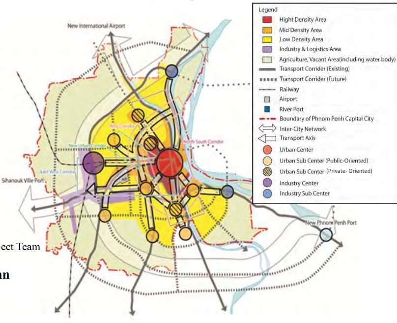
2.1.2 Future Structure of Phnom Penh Capital City
2.1.2.1 Urban Vision
As the Capital City and the centre of culture, diplomacy, economy, commerce,
industry, and employment of the country, Phnom Penh is strategically located in terms
of (i) the confluence of 3 main rivers namely Mekong, Tonle Sap, and Bassac rivers;
(ii) the junction of Asian Highways such as Indochina Southern Corridor, Central
Corridor, and Growth Corridor; and (iii) the convergence of regional industries, for
instance Sihanouk Ville Port, Phnom Penh Port, Kampong Chhnang New Air Port, and
Agro-industrial Zone in the east bank of Mekong river. All these 3 strategic locations
are the main drivers to accumulate economic activities (JICA-PPUTMP, 2035).
PPCC, on the other hand, is Cambodia's largest city, with a population of
2,189,460 (PPCA, 2020). Urbanization is expanding; the city's population is growing;
15ASSESSMENT OF URBAN TRANSPORT AND IMPACTS OF COVID-19 ON MOBILITY FOR PHNOM PENH CITY
high-rise buildings are being rapidly built in the downtown area; and traffic congestion
is becoming more prevalent as a result of the increase in privately-owned vehicles in
accordance with population growth and economic prosperity. These issues would be
uncertain.
As such, JICA-PPUTMP 2035 has set forth the statement of vision: “ PHNOM
PENH – SMART, MID-MEKONG CAPITAL CITY – IS THE ECONOMIC HUB AND CENTER OF
POPULATION IN CAMBODIA, PEOPLE FRIENDLINESS AND ENVIRONMENT FRIENDLINESS ”.
2.1.2.2 Urban Structure in 2020
(i) Land Use and Density
As indicated in Figure 9 below, land use and density can be portrayed as below:
▪ Inside of IRR (Inner Ring Road) or RR1: high and mid-density mixed land use
▪ Outside of IRR: mid-density at private development areas and the area along
NR No.4, the other low-density area.
▪ Industrial areas: located along Veng Sreng Road, NR4 and RR3
▪ Other: Green and farmland, water body, vacant land etc.
Figure 9 Urban Structure in 2020
Source: PPUTMP 2035
(ii) Urban Centres
Figure 9 above illustrates the urban centres as follows:
▪ Urban centres: Boueng kok, Monivong, and Diamond City
▪ Eight Sub-centres: Chbar Ampov, Grand Phnom Penh, Camko City, Chak
Angrae Krom, Stueng Mean Chey, Cheung Aek, Kandal, Krang Thnong,
▪ Production (industrial) centres: Chaom Chau, RR3.
16ASSESSMENT OF URBAN TRANSPORT AND IMPACTS OF COVID-19 ON MOBILITY FOR PHNOM PENH CITY
(iii) Transport Network
Major transport nodes: Phnom Penh International Airport, Phnom Penh Port,
New Phnom Penh Port
Major transport corridor: o North-South Transport Corridor including 3 sub-
corridors which support the urban institutional,
business, and commercial activities
o East-West Transport Corridor including 3 sub-
corridors which support the urban industrial and
commodity activities
o Ring Transport corridor (Grand Phnom Penh –
Stueng Mean Chey) supports the urban
connectivity.
Regional Corridor: o Growth Corridor and Indochina Central Corridor:
Sihanoukville – NR4 – PPCC – NR6
o Indochina Southern Corridor: NRI – PPCC – NR5
Mode Interchange Area: Both ends and intersection of major transport
corridors
2.1.2.3 Urban Structure in 2035
Foreseeing the continuation of the current trend of urban expansion along roads, the
progress of large-scale private urban development projects, and the degree of
involvement of PPCA in controlling/managing urban development will play an important
role in the future urban structure in 2035. The PPUTMP project team has identified
three typical future land use prospects based on this consideration as bellows:
• Alternative 1: trend-based case (current trend of urban expansion shall be
maintained)
• Alternative 2: Private-oriented case (large-scale private urban development
projects proceed and can lead to new urbanizing areas)
• Alternative 3: Public-Private case (public sector leads urban development with
private collaboration)
To make assessment on the above 3 alternatives, the PPUTMP project team mapped
out 6 criteria as such (1) impacts on environment, (2) impacts on traffic and transport,
(3) cost, (4) roles of public sector, (5) project risk, and (6) impacts on housing supply
for low- and middle-income families in the suburban areas. As a result, alternative 3 is
selected as most preferable future urban structure to be realized.
17ASSESSMENT OF URBAN TRANSPORT AND IMPACTS OF COVID-19 ON MOBILITY FOR PHNOM PENH CITY
(i) Urban Area (approximately 210 Km2)
The public sector shall lead urban development by providing the infrastructure and
utilities at north-western area of Phnom Penh Capital City (PPCC). Major directions
of urban expansion from 2020 to 2035 are set forth as follows:
▪ Large public investment will be made for constructing transport network and
utilities at the north-east area to guide private investment of housing and real
estate development. This area will form new urbanized areas
▪ Urban area in 2020 continues to expand mainly to the west direction (NR4)
▪ Urban area in 2020 expands built-up areas to the areas behind from roadside;
and
▪ Logistics and industrial complex will be formulated by government initiatives
where existing factories and warehouses in downtown area shall be relocated
to. The area is around the intersection of RR3 and railway southern line.
(ii) Land Use and Density
▪ Inside of IRR (RR1): high and mid-density mixed land use
▪ Outside of IRR (RR1): mid-density at private development areas and the area
along NR4, the other areas with low density
▪ Industrial areas: along Veng Sreng Road, NR4 and RR 3
▪ Industrial areas at RR2/NR1 and RR3/NR6
▪ Other main aears outside of RR3: green and farmland, water body, vacant
land etc.
(iii) Urban Centres
▪ Urban Centres: Boueng Kok, Mivong, Diamond City
▪ Nine Sub-centres: Chhbar Ampov, Chak Angrae Krom, Kandal, Stueng Mean
Chey, Cheung Aek, Phleung Chhesh Rotech, Krang Thnong, Grand Phnom
Penh, Camko City
▪ Production Centre (Industrial): Chaom Chau, RR3
▪ Two Production sub-centres: Preaek Aeng, Bak Kaeng
(iv) Transport Network
▪ Major Transport Nodes: Phnom Penh Port, New Phnom Port, International
Airport (Planned new international airport located in Kampong Chhnang)
▪ Major Corridors:
o North-South Transport Corridor including 5 sub-corridors
supports the urban institutional, business and commercial
activities
o East-West Transport Corridor including 3 sub-corridors
supports the urban industrial and commodity activities
o New Urban Sub-Centre Transport Corridor (Urban Centre-
Krang Thnong) supports the urban activities in the new urban
sub-centre
o Ring Tranport Corridor (Grand Phnom Penh – Stueng
Mean Chey) supports the urban connectivity
18ASSESSMENT OF URBAN TRANSPORT AND IMPACTS OF COVID-19 ON MOBILITY FOR PHNOM PENH CITY
▪ Regional Corridors:
o Growth Corridor and Indochina Central Corridor:
Sihanoukville _ NR4 – PPCC – NR6
o Indochina Southern Corridor: NR1 – PPCC – NR6
▪ Mode Interchange area: Both ends and intersection of major transport
corridors
Figure 10 Urban Structure in 2035
Source: JICA-PPUTMP, 2035
2.2 Transport Infrastructures
2.2.1 Urban Road Network Systems
The Road network system in Phnom Penh City has been crucial in contribution to
the city growth and a key driver in local economic progress. However, Phnom Penh’s
Road networks are insufficient since they do not provide effective connectivity to
suburban areas (e.g., western districts) and increase the travel distance for individuals
19ASSESSMENT OF URBAN TRANSPORT AND IMPACTS OF COVID-19 ON MOBILITY FOR PHNOM PENH CITY
who do not live in “Borey” neighbourhoods to access public facilities and services the
capital. It was also noticeable that some road designs had a negative impact on vehicle
mobility. To enhance traffic flow in some busy urban locations, several two-way roads
with large traffic volumes have been recommended to be converted to one-way streets.
Figure 11 Road Network of Phnom Penh City
Source: JICA-PPUTMP-2035
In Phnom Penh, arterial, collector, and local roads make up the road network.
According to the Department of Public Works and Transport, Phnom Penh’s Road
network had 1,379 kilometres of total road length as of June 2012, covering an area of
10,370 square kilometres (JICA-PPUTMP, 2035).
The arterial, collector, and local roads accounted for 212 km (15%), 283 km (21%),
and 884 km (64%), respectively. The arterial roads are typically 30 m in width, i.e., 18
m for the carriageway (roadway, lane) and 12 m for the sidewalk. The typical width of
the arterial roads in the urban areas is 18 m, usually divided into 4 lanes for 4-wheeled
vehicles and 2 lanes for motorcycles. However, the roadside is often used for parking
vehicles or hawkers or commercial goods. Meanwhile, in the suburban areas, most
arterial roads are -2 lane, except for NR4 and NR1.
The road network patterns in the city demonstrate significantly different
characteristics of street networks in the central and peripheral districts. Many primary
and secondary roads are disrupted due to topographical conditions such as rivers. The
roads are not well connected due to the low density of streets, particularly in the
suburban areas (Yen et al.,2019 as cited by UNDP, 2021).
20ASSESSMENT OF URBAN TRANSPORT AND IMPACTS OF COVID-19 ON MOBILITY FOR PHNOM PENH CITY
Figure 12 The road networks in the inner districts (left) and in the suburban
districts (right). Red dots represent the notes and cul-de-sacs, and the light
green represents the edges (UNDP, 2021)
The street density and connectivity between the inner and outside districts are
depicted in figure 12. The central city has orthogonal street patterns, whereas the
periphery has dispersed patterns with a high number of cul-de-sacs. The lack of
conformity with the transportation master plan, which turns suburban streets into
isolated streets with poor connections to the inner city, is a prevalent pattern that
characterizes street development in suburban areas.
The influence of private real estate developers leads to disconnected isolated
streets between central and periphery areas, resulting in unplanned patterns that
cause connectivity inconsistency. Because of these unique qualities, the one-way
street approach may not be effective in reducing traffic congestion in those areas.
2.2.2 Ring Roads
Ring roads are built with the purpose of connecting major mobility corridors (NR 1,
2, 3, 4, and 5), helping ease traffic congestion in the city centre and encouraging more
development in the peripheral districts of the city. Also, their role in providing access
from and to industrial and commercial sites near or within city boundaries for heavy
goods or vehicles is essential. The ring roads connect one corridor to another, for
instance, connecting between NR1 to NR2.
Figure 13 illustrates the development of ring roads for Phnom Penh (JICA-
PPUTMP, 2035). The second ring road, which stretches 16.67 kilometres in two lanes
from Russian Blvd to NR2 and passes through the districts of Dangkor, Sensok, and
Meanchey on its way south to Takmao, is now open (underway). The ring road No.3
was started for construction in 2019, with a total length of about 53 km, it connects NR
1, 2, 3, 4 and heads to NR 5. This ring road stretches across Kandal province for 38
km and Phnom Penh for 15 km with the road width of 27 m in the urban area and 25
m in the suburban area, using Chinese government loan (UNDP, 2021).
21ASSESSMENT OF URBAN TRANSPORT AND IMPACTS OF COVID-19 ON MOBILITY FOR PHNOM PENH CITY
The remaining part, so as to ensure a 360-degree connection around the city
center, consists of the link between the western and the eastern parts across (passing
through) the Mekong River, currently met (fulfilled) by the ferry services.
Figure 13 The Development Plan of Ring Roads in Phnom Penh (JICA-PPUTMP,
2035)
Source: JICA-PPUTMP-2035 (2014)
2.2.3 Bridges
Another discussion of the current state of road transport infrastructure concerns
bridges and ferries. Phnom Penh’s urban centre is linked by Chroy Changva bridge
(Japan bridge) in the north and Preah Monivong bridge in the southeast. Meanwhile,
the suburban area is connected by Prek Pnov bridge in the north and Takhmao bridge
crossing Tonle Bassak river in the southeast. Besides these bridges, there is one
bridge under construction, connecting inner Koh Pich city to the eastern part of Phnom
Penh, crossing Bassac River too.
As such further development of bridges to link the city to the eastern districts are
crucial to enhance the urban connectivity and mitigate traffic congestion.
Figure 14 The connection between Phnom Penh and surrounding areas via
brides
Source: UNDP (2021)
22ASSESSMENT OF URBAN TRANSPORT AND IMPACTS OF COVID-19 ON MOBILITY FOR PHNOM PENH CITY
2.2.4 Sidewalks
Standard sidewalks have been designed and built for several major streets in
Phnom Penh. However, these standard sidewalks are mostly broken and do not
provide a network of sidewalks covering the entire urban area. Sidewalks are
undoubtedly public land, but there is a lack of government enforcement to realize the
purpose of constructing and maintaining sidewalks. Currently, most sidewalks in the
city are mainly being used for parking and business activities. These activities have
obstructed pedestrians from using sidewalks, forcing them to walk on traffic lanes
instead.
Figure 15 Vendors’ tables and chairs line the sidewalk on Phnom Penh’s Preah
Sihanouk Blvd
Source: The Phnom Penh Post (2021)
According to UNDP (2021), sidewalks, and open public spaces within Phnom Penh
cover only 16.4% of total space within the city. Streets and sidewalks cover 14.3%,
which is quite low compared with Singapore (21.6%), but comparable to Bangkok
(15.9%) and Manila (15.2%). The 2.1% of open public space in Phnom Penh (e.g.,
parks, places to exercise and for civic participation), is well below the international
standard of 10%.
2.2.5 Parking
The demand for parking space in the city by far exceeds the supply (UNDP, 2021).
According to JICA-PPUTMP (2035), there is a shortage of parking spaces for
motorcycles and cars in Phnom Penh. Roadsides and sidewalks have become parking
spaces, which result in traffic flow disruption and safety concerns. There is no accurate
data regarding numbers and spaces available for vehicle parking in the city. According
to Phnom Penh Post (2019) as cited by UNDP (2021), Phnom Penh Municipality
emphasized that there are 12 parking lots in the city with a total area of 937,328 square
metre. Also, newly developed underground parking lots comprise 41,670 m2 of parking
23You can also read


