APPENDIX N - COASTAL CONSISTENCY DETERMINATION WESTMINSTER, EAST GARDEN GROVE FLOOD RISK MANAGEMENT STUDY - For - April 2020 - USACE ...
←
→
Page content transcription
If your browser does not render page correctly, please read the page content below

APPENDIX N - COASTAL CONSISTENCY DETERMINATION
                       For
  WESTMINSTER, EAST GARDEN GROVE FLOOD RISK
             MANAGEMENT STUDY

                 April 2020
Page intentionally left blank
 for double-sided printing

DEPARTMENT OF THE ARMY
                          CHICAGO DISTRICT, U.S. ARMY CORPS OF ENGINEERS
                               231 SOUTH LA SALLE STREET, SUITE 1500
                                         CHICAGO IL 60604

                                          April 13, 2020

Planning Branch

Mr. Larry Simon, Manager
Energy, Ocean Resources, and Federal Consistency
California Coastal Commission
North Central Coastal District
45 Fremont Street #2000
San Francisco, California 94105

Dear Mr. Simon:

     The U.S. Army Corps of Engineers (USACE), Chicago District, would like to thank you for
your continued coordination with regard to the Westminster, East Garden Grove Flood Risk
Management Study, Orange County, California. The Federal Consistency Determination for the
above project is currently under review (CD-0008-19). The USACE would like to submit the
following list of commitments that will be added in an addendum to CD-0008-19. These
commitments are activities that the USACE would conduct during the next phase of the project,
the preconstruction engineering and design (PED) phase. During the PED phase, detailed
designs and additional studies would be carried out to confirm assumptions that were made
during the feasibility phase of the project. The commitments to be included in the addendum to
CD-0008-19 are the following:

   (1) Coastal Act Wetland Delineation. Prior to the start of project construction, the USACE
       will submit to the Coastal Commission, for its review, a wetland delineation report
       identifying Coastal Act wetlands located in the project area, including but not limited to,
       the Bolsa Chica Channel, East Garden Grove Wintersburg Channel, Outer Bolsa Bay,
       and the Warner Avenue Bridge area. The USACE will carefully consider all comments
       by the Coastal Commission and will make all reasonable efforts to ensure that the
       concerns expressed are resolved and any necessary revisions incorporated prior to
       construction of a functional feature.

   (2) Final Impact Calculations. Prior to the start of project construction, the USACE will
       submit to the Coastal Commission, for its review, a report providing the final calculations
       for the estimated temporary and permanent project-related impacts to wetland habitat,
       mudflats, eelgrass, and environmentally sensitive upland habitat adjacent to the Warner
       Avenue Bridge and/or bluff edges east of Outer Bolsa Bay. The USACE will carefully
       consider all comments by the Coastal Commission and will make all reasonable efforts
       to ensure that the concerns expressed are resolved and any necessary revisions
       incorporated prior to onstruction of a functional feature.

   (3) Final Mitigation and Monitoring Plans. Prior to the start of project construction, the
       USACE will submit to the Coastal Commission, for its review, final mitigation and
       monitoring plans for unavoidable project impacts to coastal resources, including
       wetlands, mudflats, eelgrass, and environmentally sensitive upland habitat. Plans will
       include, but not be limited to, a revised eelgrass mitigation plan consistent with the
       California Eelgrass Mitigation Policy, revised mitigation plans for impacts to California
       least tern foraging, and plans for fish habitat improvements in Reach 1 of the East
       Garden Grove Wintersburg Channel. Mitigation and monitoring plans will include
       provisions for adaptive management measures (refer to Appendix M – Conceptual
       Mitigation Strategy of the main report) given the length of time that will exist between
-2-

       Coastal Commission action on CD-0008-19 and project implementation, the length of the
       construction time period, and the length of time between completion of construction and
       significant flood/stormflow events that hold the potential to adversely affect coastal
       resources and trigger mitigation requirements. The USACE will carefully consider all
       comments by the Coastal Commission and will make all reasonable efforts to ensure
       that the concerns expressed are resolved and any necessary revisions incorporated
       prior to construction of a functional feature.

   (4) Final Plans for Trash and Debris Collection. Prior to the start of project construction, the
       USACE will submit to the Coastal Commission, for its review, final plans for trash and
       debris collection systems in the modified flood control channels to minimize the amount
       of trash and debris entering Anaheim Bay, Outer Bolsa Bay, the Muted Tidal Pocket, and
       the Bolsa Chica Ecological Reserve. The USACE will carefully consider all comments
       by the Coastal Commission and will make all reasonable efforts to ensure that the
       concerns expressed are resolved and any necessary revisions incorporated prior to
       construction of a functional feature.

   (5) Final Mitigation Plans for Public Access Impacts. Prior to the start of project construction,
       the USACE will submit to the Coastal Commission, for its review, final mitigation plans
       for temporary and permanent impacts to public access at the Warner Avenue Bridge, the
       pedestrian walk bridge parallel to the Warner Avenue Bridge, and the bridge over the
       culverts between Outer and Inner Bolsa Bays and over the tide gates at the terminus of
       the East Garden Grove Wintersburg Channel. The submittal will include final plans for
       improvements to and/or replacement of structures that currently provide public access in
       this area. The USACE will carefully consider all comments by the Coastal Commission
       and will make all reasonable efforts to ensure that the concerns expressed are resolved
       and any necessary revisions incorporated prior to construction of a functional feature.

    We understand that in the event the Coastal Commission staff identify shortcomings in the
content of any of these plans regarding protection of coastal resources and environmentally
sensitive habitats, and if the Corps and the Coastal Commission staff are unable to resolve any
disagreements over the plans, Coastal Commission staff may bring the matter back to the
Commission for a public hearing on the question of whether the project is likely to have an effect
on coastal resources that is substantially different from what was originally described and
anticipated and, as a result, the project no longer appears consistent with the California Coastal
Management Program.

    As stated before, please include the above list of commitments to CD-0008-19 as an
addendum to the document you currently have. The USACE will also add the above list of
commitments as an addendum to the Consistency Determination that will be released in the
upcoming months for the State and Agency review as well as the public review of the Final
Report under the National Environmental Policy Act. Please direct any questions regarding this
letter to Ms. Shawna Herleth-King at (312) 560-3285 or Shawna.S.Herleth-
King@usace.army.mil.

                                                Sincerely,

                                                 Susanne J. Davis, P.E.
                                                 Chief, Planning Branch
                                                 USACE, Chicago District
Coastal Consistency Determination
 Westminster-East Garden Grove
 Flood Risk Management Project
    Orange County, California

            Prepared for:

     US Army Corps of Engineers
      Lakes and Rivers Division
          Chicago District

            Prepared by:

      CHAMBERS GROUP, INC.
   5 Hutton Centre Drive, Suite 750
     Santa Ana, California 92707
           (949) 261-5414

             April 2020
Coastal Consistency Determination, Westminster-East Garden Grove Flood Risk Management Project
                                                      Orange County, CA

                                                          TABLE OF CONTENTS

                                                                                                                                            Page

SECTION 1.0 – AUTHORITY ................................................................................................................... 4

SECTION 2.0 – DETERMINATION........................................................................................................... 4

SECTION 3.0 – STANDARD OF REVIEW .................................................................................................. 4

SECTION 4.0 – PROJECT DESCRIPTION .................................................................................................. 6
   4.1 PROJECT BACKGROUND ............................................................................................................... 6
         4.1.1 Project Area ..................................................................................................................... 7
         4.1.2 Project Channels and Reaches ......................................................................................... 9
         4.1.3 Bolsa Chica Ecological Reserve ...................................................................................... 10
         4.1.4 Essential Fish Habitat ..................................................................................................... 11
   4.2 PURPOSE AND NEED ................................................................................................................... 11
   4.3 PROJECT OBJECTIVES AND CONSTRAINTS .................................................................................. 12
         4.3.1 Objectives....................................................................................................................... 12
         4.3.2 Constraints ..................................................................................................................... 12
   4.4 ALTERNATIVES ............................................................................................................................ 12
         4.4.1 Alternative 1 – No Action Alternative ............................................................................ 13
         4.4.2 Alternative 2 –Minimum Channel Modifications ........................................................... 14
         4.4.3 Alternative 3 –Maximum Channel Modifications .......................................................... 16
         4.4.4 Construction Phases Schedule ....................................................................................... 18

SECTION 5.0 – CONSISTENCY WITH THE CALIFORNIA COASTAL ACT .................................................... 21
   5.1 ARTICLE 1 – GENERAL (SECTION 30200) ..................................................................................... 21
   5.2 ARTICLE 2 – PUBLIC ACCESS (SECTIONS 30210 – 30214) ........................................................... 21
   5.3 ARTICLE 3 – RECREATION (SECTIONS 30220 – 30224) ............................................................... 22
   5.4 ARTICLE 4 – MARINE ENVIRONMENT (SECTION 30230 – 30237) ............................................... 23
   5.5 ARTICLE 5 – LAND RESOURCES (SECTIONS 30240 – 30244) ....................................................... 26
   5.6 ARTICLE 6 – DEVELOPMENT (SECTIONS 30250 – 30255) ........................................................... 28
   5.7 ARTICLE 7 – INDUSTRIAL DEVELOPMENT (SECTIONS 30260 – 30265.5) .................................... 31

SECTION 6.0 – COMMITMENTS .......................................................................................................... 32

SECTION 7.0 – REFERENCES ................................................................................................................ 34

APPENDIX A – SITE PHOTOGRAPHS

Chambers Group, Inc.                                                                                                                             ii
20801
Coastal Consistency Determination, Westminster-East Garden Grove Flood Risk Management Project
                                                       Orange County, CA

                                                                LIST OF FIGURES

                                                                                                                                                  Page

Figure 1: Project Location ............................................................................................................................. 6

Figure 2: Project Area Waterbodies .............................................................................................................. 8

Figure 3: Location of Scenic Overlooks within the Bolsa Chica Ecological Reserve .................................... 30

                                                                 LIST OF TABLES

Table 1: Westminster NED Construction Schedule ..................................................................................... 14

Table 2: Westminster LPP Construction Schedule ...................................................................................... 17

Table 3: Construction Phases for Warner Avenue Bridge Expansion ......................................................... 19

Table 4: Construction Phases for Tide Gate Removal and Replacement.................................................... 19

Table 5: Construction Phases for Reach 1................................................................................................... 19

Table 6: Construction Phases for Reach 23................................................................................................. 20

Table 7: Construction Phases for Reach 21 (LPP). ...................................................................................... 20

Table 8: Construction Phases for Reach 21 (LPP). ...................................................................................... 25

Chambers Group, Inc.                                                                                                                                    ii
20801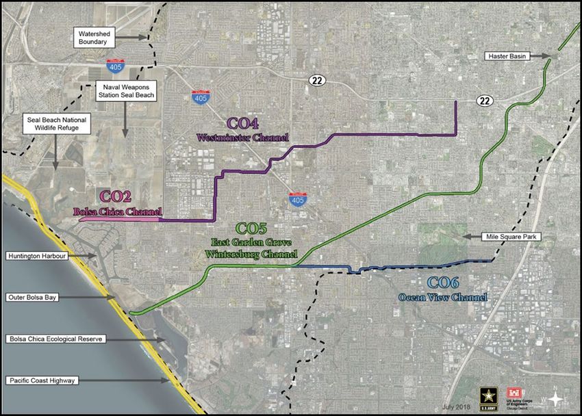
Coastal Consistency Determination, Westminster-East Garden Grove Flood Risk Management Project
                                                  Orange County, CA

Acronyms and Abbreviations

ACE             annual chance of exceedance

BA              Biological Assessment

BCER            Bolsa Chica Ecological Reserve

BO              Biological Opinion

CCA             California Coastal Act of 1976, as amended

CCC             California Coastal Commission

CCMP            California Coastal Management Program

CCD             Coastal Consistency Determination

CDFW            California Department of Fish and Wildlife

C.F.R.          Code of Federal Regulations

CY              cubic yards

CZMA            Coastal Zone Management Act of 1972, as amended

DO              dissolved oxygen

EA              Environmental Assessment

ESA             Endangered Species Act

FONSI           Finding of No Significant Impact

FY              Fiscal Year

LPP             Locally Preferred Plan

LUP             Land Use Plan

MLLW            Mean Lower-Low Water

MSCMA           Magnuson-Stevens Conservation and Management Act

NED             National Economic Development

NOAA Fisheries National Oceanic and Atmospheric Administration, National Marine Fisheries Service

NRHP            National Register of Historic Places

Chambers Group, Inc.                                                                                        ii
20801
Coastal Consistency Determination, Westminster-East Garden Grove Flood Risk Management Project
                                                  Orange County, CA

O&M             Operations and Maintenance

RWQCB           Regional Water Quality Control Board

SHPO            State Historic Preservation Officer

USFWS           United States Fish and Wildlife Service

USACE           United States Army Corps of Engineers

Chambers Group, Inc.                                                                                        iii
20801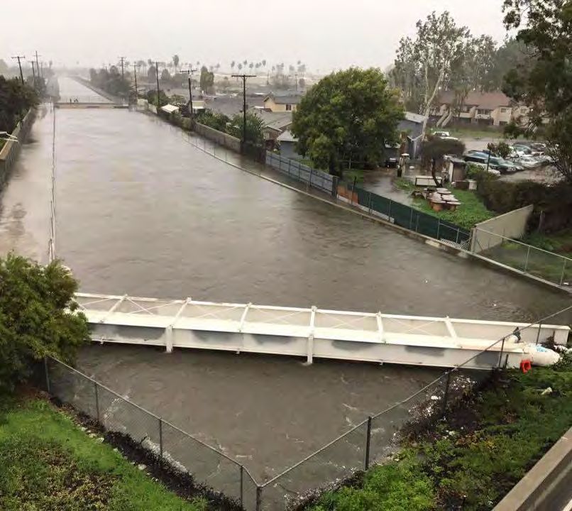
Coastal Consistency Determination, Westminster-East Garden Grove Flood Risk Management Project
                                                  Orange County, CA

                                          SECTION 1.0 – AUTHORITY

The United States Army Corps of Engineers (USACE), Chicago District, has prepared this Coastal
Consistency Determination (CCD) in accordance with the Federal Coastal Zone Management Act of 1972,
as amended, (CZMA) (Title 16 United States Code [U.S.C.] § 1451 et seq.) and its implementing regulations,
Federal Consistency with Approved Coastal Management Programs (Title 15 Code of Federal Regulations
[C.F.R.] Part 930). The environmental impact statement, in conjunction with the 40 C.F.R. Part 230 -
Section 404(b)(1) guidelines and public notice coordination process, can be used as a guide in formulating
environmentally acceptable alternatives.

The Westminster feasibility study is being conducted in accordance with the study resolution adopted by
the Committee on Public Works, House of Representatives Committee on Public Works on May 8, 1964
(Flood Control Act of 1938), which reads:

   "Resolved by the Committee on Public Works of the House of Representatives, United States, that
   the Board of Engineers for Rivers and Harbors is hereby requested to review the reports on (a) San
   Gabriel River and Tributaries, published as House Document No. 838, 76th Congress, 3d Session;
   (b) Santa Ana River and Tributaries, published as House Document No. 135, 81st Congress, 1st
   Session; and (c) the project authorized by the Flood Control Act of 1936 for the protection of the
   metropolitan area in Orange County, with a view to determining the advisability of modification of
   the authorized projects in the interest of flood control and related purposes."

                                       SECTION 2.0 – DETERMINATION

USACE has evaluated the Recommended Plan and has found it is consistent to the maximum extent
practicable with the California Coastal Management Program (CCMP), pursuant to the requirements of
the Coastal Zone Management Act of 1972, as amended, (CZMA), and the California Coastal Act of 1976,
as amended (CCA). The Project (i.e., Recommended Plan), for purposes of this Coastal Consistency
Determination (CCD), is defined as the Locally Preferred Plan (LPP). The environmental consideration and
consistency sections below provide the basis for the finding. USACE requests that the California Coastal
Commission (CCC) concur with this CCD.

                                    SECTION 3.0 – STANDARD OF REVIEW

Under Section 307 (c)(1) of the CZMA, 16 USC Section 1456 (c) (1), federal activities that affect any land
or water use or natural resource of the coastal zone are required to be consistent with the affected state's
coastal management program to the "maximum extent practicable." Section 930.32 of the National
Oceanic and Atmospheric Administration's regulations implementing the CZMA (15 CFR part 930) defines
"consistent to the maximum extent practicable" as follows:

(a)(1) The term ‘‘consistent to the maximum extent practicable’’ means fully consistent with the
enforceable policies of management programs unless full consistency is prohibited by existing law
applicable to the Federal agency.

The standard of review for federal consistency determinations consists primarily of the principal
components of the California Coastal Management Program (CCMP), namely the policies of Chapter 3 of
the Coastal Act. Section A(6) of the Introduction to the CCMP also states that once incorporated into the
CCMP, certified Local Coastal Programs (LCPs) "will be used in making federal consistency

Chambers Group, Inc.                                                                                        4
20801
Coastal Consistency Determination, Westminster-East Garden Grove Flood Risk Management Project
Orange County, CA
determinations". If an LCP that the Commission has certified and incorporated into the CCMP provides
development standards that are applicable to the project site, the LCP can provide guidance in applying
Chapter 3 policies in light of local circumstances. If the Commission has not incorporated the LCP into the
CCMP, it cannot guide the Commission's decision, but it can provide background information.
Chambers Group, Inc. 5
20801Coastal Consistency Determination, Westminster-East Garden Grove Flood Risk Management Project
Orange County, CA
SECTION 4.0 – PROJECT DESCRIPTION
4.1 PROJECT BACKGROUND
The Westminster East Garden Grove Flood Risk Management Project (Proposed Project) evaluates the
flood risk associated with the primary drainage channels in the Westminster Watershed and will examine
opportunities to improve the function of the constructed flood control channels or storm drains of the
East Garden Grove-Wintersburg (EGGW/C05), Oceanview (OV/C06), Westminster (W/C04), and Bolsa
Chica (BCFC/C02) Channel Systems (Figure 1). The Westminster Watershed is designated with the letter
“C” by Orange County. As such, these channels are numbered C05, C06, C04, and C02, as identified above.
The Proposed Project would allow the modification of the C05, C06, C04, and C02 channels to provide
100-year flood conveyance of stormwater.
Figure 1: Project Location
The evaluation of flood risk will include the identifying measure to reduce flood hazards associated with
the Westminster Channels, such as risks to life safety, damages to residential and commercial structures,
and public infrastructure. The evaluation will also consider measures to reduce flood impacts downstream
of the channels in the vicinity of Outer Bolsa Bay.
Chambers Group, Inc. 6
20801Coastal Consistency Determination, Westminster-East Garden Grove Flood Risk Management Project
Orange County, CA
Engineering Regulation (ER) 1105-2-100 and ER 11165-2-21 set minimum drainage requirements to
qualify for federal interest consideration under the flood risk management authority. The requirements
are as follows:
• Flows within the channel must be greater than 800 cubic feet per second (cfs) (22.7 cubic
meters/second [cms]) for the 0.1 annual chance of exceedance (ACE) storm event, except in areas
of hydraulic disparity where flows do not exceed 800 cfs (22.7 cms) for the 0.1 ACE storm event,
but exceed 1,800 cfs (51.0 cms) for the 0.01 ACE storm event.
4.1.1 Project Area
The Proposed Project lies in the area referred to as the Westminster watershed, a sub-watershed of the
Anaheim Bay-Huntington Harbour Watershed (identified by the U.S. Environmental Protection Agency
[USEPA] as # 18070201) located between the lower reaches of the San Gabriel River watershed and the
Santa Ana River watershed in Orange County, California. The study area is approximately 25 miles
southeast of downtown Los Angeles, California.
The Westminster watershed lies on a flat coastal plain, approximately 90 square miles in area and is almost
entirely urbanized with residential and commercial development. The Santa Ana River historically
meandered widely over this coastal plain. Channelization occurred throughout the mid-20th century with
containment in concrete channels and earthen berm channels from Anaheim Bay to the north, and
southward to Newport Bay. Urbanization within the Westminster watershed generally followed historic
alignments of the former Santa Ana River drainage system. C05 and C02 systems collect runoff from the
urbanized areas in the cities of Anaheim, Cypress, Fountain Valley, Garden Grove, Huntington Beach, Los
Alamitos, Santa Ana, Seal Beach, Stanton, and Westminster in the County of Orange. Typical flow in the
Anaheim Bay-Huntington Harbour watershed is almost completely dry weather runoff. There is no
dominant river for the watershed that drains a substantial portion of the watershed. Channels that drain
the watershed include Stanton Storm Channel; C02; Anaheim Harbor City Channel; C04; C05; and C06.
The channels within the Westminster watershed collect local storm water runoff and vary in size,
geometry, and lining material. Typical channel configurations are described below and vary by reach
throughout the channel systems.
• Concrete rectangular channels: Vertical channel walls with concrete lined sides and bottom.
• Riprap-lined trapezoidal channels: Sloped channels that are lined with riprap; soft or unpaved
bottom.
• Concrete-lined trapezoidal channels: Sloped channels with concrete-lined sides and bottoms.
• Enclosed culverts: Rectangular or box conduits that are not exposed at the surface.
• Levees: Earthen berms (3H:1V TYP.) are located along channels in the flattest downstream extents
of the watershed.
• Steel Sheet Pile: Rectangular channels comprised of vertical sheet pile walls with soft channel
bottom in between.
Current data for C05 are from a sampling station at Gothard Street. C05 terminates with one-way flap
gates at the south end of Outer Bolsa Bay. From Outer Bolsa Bay, runoff is conveyed under the Warner
Avenue Bridge through Huntington Harbour, Anaheim Bay and ultimately to the Pacific Ocean. Tidal
waters flow between Outer and Inner Bolsa Bay through culverts that partly restrict tidal exchange. The
tidal range in Inner Bolsa Bay is muted to about 22 percent of that of Outer Bolsa Bay (CSLC et al. 2001).
Chambers Group, Inc. 7
20801Coastal Consistency Determination, Westminster-East Garden Grove Flood Risk Management Project
Orange County, CA
The downstream receiving waters are comprised of the following four regions (Figure 2):
Figure 2: Project Area Waterbodies
Huntington Harbour – Sunset Harbour
The City of Huntington Beach is a residential community that includes five man-made islands and
waterways used for boating. FEMA maps from a detailed floodplain study dated 2010 show the channels
within Huntington Harbour contain up to the 0.01 ACE storm event.
Seal Beach National Wildlife Refuge
Seal Beach National Wildlife Refuge (NWR) was developed through a collaboration of the U.S. Fish and
Wildlife Service (USFWS) and the Department of the Navy. The refuge is part of the Seal Beach Naval
Weapons Station located to the northwest of the C02/C04 channel confluence.
Anaheim Bay
Anaheim Bay serves as the outlet to the Pacific Ocean for the wildlife refuge and the C02/C04 channel
system. The Navy is currently investigating ways to modify navigation in Anaheim Bay to redirect civilian
Chambers Group, Inc. 8
20801Coastal Consistency Determination, Westminster-East Garden Grove Flood Risk Management Project
Orange County, CA
ships in Huntington Harbour away from the facilities at the Seal Beach Naval Weapons Station. These
changes would neither affect nor conflict with the project alternatives.
Bolsa Chica Ecological Reserve (BCER)
This nature reserve is designed to protect a significant coastal wetland and provide habitat for endemic
plant and animal species, including federally listed endangered species, and includes Inner and Outer
Bolsa Bay.
4.1.2 Project Channels and Reaches
The study will focus only on channel reaches C02, C04, C05, and C06. The study will not include reaches
of C02 upstream of the C02/C04 confluence, or the C03 channel, Anaheim Harbor City Channel.
C02 – Bolsa Chica Channel
For the C02 channel, this study focuses only on the portion that extends from the confluence with the C04
channel, near the southeastern corner of the Seal Beach Naval Weapons Station, to where the channel
discharges into Huntington Harbour. This channel segment is approximately 1.5 miles long and provides
flood risk management for the Huntington Beach, Huntington Harbour, and the Seal Beach Naval
Weapons Station.
C04 - Westminster Channel
The C04 channel is approximately 7.8 miles in length and provides flood risk management for the cities of
Garden Grove, Westminster, and Huntington Beach. The channel begins south of Highway 22 and flows
westward past Westminster Memorial Park Cemetery, Interstate 405, and Westminster Mall, joining with
the C02 channel near the southeastern corner of the Seal Beach Naval Weapons station.
C05 – East Garden Grove/Wintersburg Channel
The C05 channel is approximately 11.6 miles in length and provides flood risk management for the cities
of Santa Ana, Garden Grove, Westminster, and Huntington Beach. The channel begins west of the
intersection of Highway 5, Highway 57, and Highway 22 in the City of Santa Ana and flows southwest
through Haster Basin, under Interstate 405, and through the Bolsa Chica Ecological Reserve, ultimately
discharging into Outer Bolsa Bay. Haster Basin is a detention basin that controls flows entering the C05
channel with a pump system.
C06 - Ocean View Channel
The C06 channel is approximately 4.1 miles in length and provides flood risk management for the cities of
Fountain Valley and Huntington Beach. The channel begins 0.5 miles east of Mile Square Regional Park in
the City of Fountain Valley and flows westward through Mile Square Regional Park and under Interstate
405, ultimately discharging into the C05 channel at the confluence near Gothard Street in Huntington
Beach, CA. Mile Square Regional Park is a 640 acre park that is home to multiple golf courses, a 55 acre
recreation center, and two lakes. This park is located in the City of Fountain Valley but is a key recreation
resource for communities throughout the watershed.
Chambers Group, Inc. 9
20801Coastal Consistency Determination, Westminster-East Garden Grove Flood Risk Management Project
Orange County, CA
4.1.3 Bolsa Chica Ecological Reserve
The lower segment of the C05 channel bisects the reserve and discharges into Outer Bolsa Bay, a body of
water that is contained within the Bolsa Chica Ecological Reserve (BCER). The BCER is owned by California
State Lands Commission and is home to a variety of local wildlife and habitat types. The BCER is comprised
of the following areas:
Full Tidal Basin
The Full Tidal Basin is located along the eastern edge of the C05 channel and is considered an
environmentally sensitive area. The Full Tidal basin is separated from the C05 channel, the Muted Tidal
Basin, and Inner Bolsa Bay by levees. Water exchange between the Muted Tidal Basin and the Full Tidal
Basin is permitted by a series of culverts and is controlled by flap gates that respond to changes in tide.
Water exchange between the Seasonal Pond Area and the basin is controlled by flap gates that respond
to changes in tide. The basin is connected to the Pacific Ocean by an ocean outlet that passes under Pacific
Coast Highway at the southern tip of the Full Tidal Basin.
Muted Tidal Basin
The Muted Tidal Basin is located northeast of the Full Tidal Basin. The Muted Tidal Basin is divided into
three cells that only allow water to move between them through overflow weirs during larger storm
events. Each cell is separated from the Full Tidal Basin and the C05 channel by a levee. Culverts permit
water exchange between the Muted Tidal Basin and the Full Tidal Basin, and flap gates allow regular, but
muted tidal influence.
Inner Bolsa Bay
Inner Bolsa Bay is located between Pacific Coast Highway and the Full Tidal Basin. The bay is isolated from
the Full Tidal Basin by a levee and is separated from Outer Bolsa Bay by tide gates. The tide gates permit
water from Outer Bolsa Bay to enter Inner Bolsa Bay and maintain a tidal influence within Inner Bolsa Bay.
There is no water exchanged between the Full Tidal Basin and Inner Bolsa Bay.
Muted Tidal Pocket
The Muted Tidal Pocket is separated from the Full Tidal Basin by the C05 channel. The Muted Tidal Pocket
is isolated from the C05 channel by a levee and a tide gate. A culvert permits water from Outer Bolsa Bay
to enter the Muted Tidal Pocket, maintaining a muted tidal influence.
Seasonal Ponds
The Seasonal Ponds are located along the eastern edge of the Full Tidal Basin and are separated from the
Full Tidal Basin by a levee system. A single culvert controls discharge from the Seasonal Ponds into the
Full Tidal Basin. This area is subject to runoff from surrounding developments.
Outer Bolsa Bay
Outer Bolsa Bay is located at the mouth of the C05 channel. Water exchange between the C05 channel
and the bay is controlled by tide gates. Outer Bolsa Bay is connected to Inner Bolsa Bay by different tide
gates, and a culvert connects Outer Bolsa Bay to the Muted Tidal Pocket just north of the C05 outfall.
Chambers Group, Inc. 10
20801Coastal Consistency Determination, Westminster-East Garden Grove Flood Risk Management Project
Orange County, CA
Water is discharged from Outer Bolsa Bay under the Warner Avenue Bridge into Huntington Harbour.
Outer Bolsa Bay is separated from the Pacific Ocean by Pacific Coast Highway and Bolsa Chica State Beach.
4.1.4 Essential Fish Habitat
Essential Fish Habitat (EFH) means those waters and substrate necessary to fish for spawning, breeding,
feedings, or growth to maturity. For interpreting the definition of EFH, “waters” includes aquatic areas
and their associated physical, chemical, and biological properties used by fish, and may include areas
historically used by fish where appropriate. “Substrate” includes sediment, hard bottom, structures
underlying the water, and associated biological communities. The term “necessary” means the habitat
required to support a sustainable fishery and a healthy ecosystem. The term “spawning, breeding,
feeding, or growth to maturity” covers a species full life cycle.
EFH potentially present within the study area was queried using GIS data made available by the National
Oceanic and Atmospheric Administration’s (NOAA) National Marine Fisheries Service. It was found that
EFH for groundfish, coastal pelagic species, and finfish, and market squid is present within Anaheim Bay,
Huntington Harbour, and Outer and Inner Bolsa Bay. EFH for these species also extends upstream into
reaches of channels C02 and C05. Outside of the project area, but within Anaheim Bay and along the
coastline, EFH also exists for krill (i.e., Euphausia pacifica, Thysanoessa spinifera, and other krill species)
as well as for the aforementioned species.
Coastal pelagic species that may be found in the area include Pacific sardine (Sardinops sagex), Pacific
(chub) mackerel (Scomber japonicus), northern anchovy (Engraulis mordax), and jacksmelt (Atherinopsis
californiensis). Coastal pelagic species tend to be most common in the upper mixed layer of the ocean
(above the thermocline) in a broad band (up to hundreds of miles wide) along the coast. Coastal pelagic
species may occur in shallow embayments and brackish water, but do not depend on these habitats to
any significant degree.
No Pacific salmon EFH, Habitat Areas of Particular Concern (HAPC), or EFH Areas Protected from Fishing
(EFHA) were identified within the vicinity of the Proposed Project area. Additionally, EFH for Pacific Highly
Migratory Species (PHMS) — thresher shark (Alopias spp.), bluefin tuna (Thunnus thynnus), dolphinfish
(Coryphaena hippurus), and swordfish (Xiphias gladius) — is located approximately 1 mile off the coast;
therefore, these species are not anticipated to be within the vicinity of the Proposed Project area.
4.2 PURPOSE AND NEED
The purpose of this study is to evaluate flood risk within the Westminster watershed following the
completion of channel modifications for the Santa Ana River and the removal of the Westminster
watershed from the Santa Ana River floodplain. Flood risk within the watershed can be attributed to
drainage channels that collect surface runoff and convey it to the Pacific Ocean. Portions of the
Westminster watershed are the only areas left in Orange County that are still within the Federal
Emergency Management Agency (FEMA) 1% Floodplain. Preliminary analysis shows that flooding overtops
the existing drainage channel infrastructure in the study area between the 20% and 10% ACE storm events
(5 and 10 year recurrence intervals, respectively), putting approximately 400,000 area residents and
44,000 structures at rick of inundation during a 0.2% ACE event (“500-year storm”). Overbank flooding
also impacts traffic in the project area, causing closures on local roads as well as major routes, including
the Pacific Coast Highway (PCH) and Interstate-405. In total, the study area experiences approximately
Chambers Group, Inc. 11
20801Coastal Consistency Determination, Westminster-East Garden Grove Flood Risk Management Project
Orange County, CA
$72,000,000 (Fiscal Year 2020 price levels, 2035 base year, 2.75% federal discount rate) in average annual
equivalent direct damages as a result of overbank flooding.
Hydraulic analysis shows that the following channel segments may not meet the drainage requirements
criteria for with project conditions.
• C04 – Portions of the channel that are approximately 0.25 miles upstream of the Ward Street
crossing. Flows upstream of the crossing do not exceed 770 cfs (21.8 cms) for the 0.1 ACE storm
event.
• C05 – Portions of the channel that are upstream of the Garden Grove Freeway. Flows in the
channel between Westminster Avenue and Haster Basin do not exceed 460 cfs (13.0 cms) for the
0.1 ACE storm event.
• C06 – Portions of the channel that are approximately 900 feet upstream of Brookhurst Street.
Flows in the channel upstream of Brookhurst Street do not exceed 800 cfs (22.7 cms) for the 0.1
ACE storm event.
4.3 PROJECT OBJECTIVES AND CONSTRAINTS
The goal of the study is to identify a sustainable flood risk management solution within the Westminster
watershed to reduce flooding caused by overtopping of the C05/C06 and C02/C04 channel systems.
Detailed descriptions of the Objectives and Constraints are discussed in the EIS/EIR.
4.3.1 Objectives
• Reduce the risk of flood damages to structures and infrastructure;
• Reduce life-safety risk associated with overbank flooding;
• Reduce the risk of downstream flood damages; and,
• Promote compatible recreation.
4.3.2 Constraints
• Limit extensive changes to local land use designations and zoning by limiting channel
modifications to within the existing channel right of way, when feasible.
• Minimize impacts to culturally sensitive areas.
• Limited change in elevation across the watershed reduces opportunities for lowering the invert
of the existing channel systems.
• Alternatives should avoid induced adverse hydraulic impacts relative to existing conditions and
comply with floodplain management requirements.
• Do not impact the contaminated soil containment sites adjacent to Reaches 1 & 2 of the C05
channel and Bolsa Chica Ecological Reserve.
4.4 ALTERNATIVES
The following strategies were used for developing study alternatives.
• Focus on Improving Channel Conveyance – This strategy aims to reduce the risk and impacts of
flooding by transporting flood waters more efficiently, especially in upstream channel reaches
where the watershed has more slope.
Chambers Group, Inc. 12
20801Coastal Consistency Determination, Westminster-East Garden Grove Flood Risk Management Project
Orange County, CA
• Focus on Increasing Channel Capacity – This strategy aims to reduce the risk and impacts of
flooding by increasing the volume of flood water storage within the existing drainage channels.
• Focus on Improving Downstream Conveyance – This strategy aims to reduce the risk and impacts
of flooding downstream by improving flow in the receiving waters of the study channels. While
downstream conveyance modifications are unlikely to provide significant flood damage risk
reduction alone, it is recognized that any modifications to improve conveyance and capacity
upstream would exacerbate existing flow restrictions downstream.
Based on the measures and the strategies developed for alternative development, several action and one
no action alternative plans were originally developed for project consideration. Appendix H of the EIS/EIR
for this project provides the details of the measures considered during alternative development.
Alternatives carried forward are described in further detail below.
Water Diversion
Water diversion methods would be the same for each of the action alternatives. In the reaches where
sheet pile is being placed (e.g., downstream reaches of C02 and C05) full dewatering will not occur.
Cofferdams will be used to block off one side of the channel where work is being conducted, but the other
side will be left open for water to flow through in the channel. In the reaches where concrete is being
placed, water will be completely diverted around the work area. Cofferdams will be used at the upstream
and downstream areas to completely block off from flow the section where work is occurring. Water from
upstream will be completely diverted around the site through a pipe to the downstream area.
Non-Structural Measures
Retained nonstructural measures are included in every action alternative listed (i.e., all alternatives except
No Action) and include removal of impediments to flow. These measures are the same for each action
alternative.
Removal of Impediments to Flow: Removal of impediments to flow is a nonstructural maintenance
measure that involves the removal of vegetation, sediment, and other debris that can accumulate in the
channel and interfere with the conveyance of flood flows. Removing impediments to flow would be
implemented on a priority-basis, increasing maintenance investments in locations that are known to
require greater capacity during flood events.
4.4.1 Alternative 1 – No Action Alternative
Under the No Action Alternative, no management measures would be implemented to reduce the current
risk of flood damage in the project area. Flooding will continue throughout the Westminster watershed
due to the insufficient capacity of the existing channel systems. This will continue to cause damages to
structures as well as road closures in the project area as a result of channel overtopping. Outer Bolsa Bay
will continue to flood during frequent storm events, impacting traffic on the Pacific Coast Highway. The
oil wells in the Bolsa Chica Ecological Reserve will remain at risk of inundation by flows that overtop the
C05 channel upstream of the reserve and travel overland into the Muted Tidal Basin and Seasonal Pond
area. Under the No Action Alternative, bluff erosion in Outer Bolsa Bay is anticipated to continue, as well
as erosion along the Pacific Coast Highway and at Warner Avenue (i.e., where it crosses Outer Bolsa Bay).
Chambers Group, Inc. 13
20801Coastal Consistency Determination, Westminster-East Garden Grove Flood Risk Management Project
Orange County, CA
4.4.2 Alternative 2 –Minimum Channel Modifications
The Minimum Channel Modifications Plan is the National Economic Development (NED) Plan. Consistent
with the formulation strategy to “focus on improving channel conveyance,” this alternative would reduce
flood risk within the watershed by improving conveyance efficiency of existing channels. Trapezoidal
channels within C02, C04, C05, and C06 that currently have an earthen bottom and either earthen or
riprap banks would be lined with concrete. There would be no alteration to reaches that are rectangular
in shape or lined with concrete, nor to reaches of in-channel box and pipe structures. The leveed areas in
the downstream reaches of C02 and C05 (reaches 23 and 1, respectively) would be improved to reduce
the risk of levee failure. Modifications in these reaches would include installation of steel sheet pile
channel walls and preservation of existing soft bottom, tidally-influenced habitat.
Additional downstream measures would be combined with the in-channel measures to address existing
flooding in Outer Bolsa Bay and to account for increased flow volumes that result from increased
conveyance capacity in the channels. The tide gates on C05 would be removed to improve the flow
conditions through the lower reaches of the C05 channel. The current tide gates leak and therefore, allow
saltwater to intrude upstream in C05. This saltwater influence extends upstream of Outer Bolsa Bay for
approximately 2.5 miles. A bridge will replace the tide gates and allow emergency vehicle access similar
to the current tide gate structure. This alternative allows for continued tidal influence in the lower reaches
of C05, thus lessening impacts to the existing ecological conditions. This alternative also includes the
widening of the Outer Bolsa Bay Channel just upstream of the Warner Avenue Bridge. Widening of the
channel would require that the Warner Avenue Bridge and the pedestrian bridge at the Bolsa Chica
Conservancy be increased in span. Widening of the Outer Bolsa Bay Channel would improve conveyance
as well as the hydraulic efficiency of the lower reaches of C05.
Compatible nonstructural measures would be incorporated to lessen the life safety risk associated with
flooding in the project area. Compatible nonstructural measures that were considered in the development
of this alternative include removal of impediments to flow.
The NED Plan preconstruction engineering and design (PED) and construction schedules begin at the lower
reaches of C02 and C05 and progress upstream. Additional studies may be conducted during the PED
phase for each reach to refine and provide greater detail of project area conditions prior to construction.
The PED schedule for C02 and C04 is expected to begin in January 2021 and be completed by October
2027; construction is expected to occur between May 2022 and November 2029. The PED schedule for
C05 and C06 is expected to begin in January 2020 and be completed by June 2028; construction is
expected to occur between May 2022 and July 2031. The table below provides a summary of the project
dates by channel and reach for the NED Plan.
Table 1: Westminster NED Construction Schedule
Anticipated
Preliminary Anticipated
Channel Reach Location
Engineering Design Construction Dates
(PED) Dates
C02 Huntington Harbour
REACH 23 1/1/21 2/11/21 5/20/22 12/22/22
to C04
Chambers Group, Inc. 14
20801Coastal Consistency Determination, Westminster-East Garden Grove Flood Risk Management Project
Orange County, CA
Anticipated
Preliminary Anticipated
Channel Reach Location
Engineering Design Construction Dates
(PED) Dates
C04 REACH 20 Bolsa Chica to
10/1/21 11/11/21 2/17/23 1/15/26
McFadden Ave
McFadden Ave to D/S
10/25/24 12/5/24 3/13/26 3/18/27
Bolsa Ave
D/S Bolsa Ave to U/S
12/26/25 2/5/26 5/14/27 12/2/27
Edwards
REACH 22 D/S Brookhurst to U/S
9/11/26 10/22/26 1/28/28 12/5/28
Ward
U/S Ward to U/S
9/14/27 10/26/27 1/30/29 11/22/29
Westminster
C05 REACH 1a Warner Ave Bridge
and Huntington 1/1/20 2/11/21 5/20/22 8/3/23
Harbour Armoring
Tidegates to 2600' D/S
1/1/20 2/11/21 5/20/22 8/3/23
Graham
U/S Warner to D/S
REACH 1b 1/1/20 2/11/21 5/20/22 8/3/23
Goldenwest
U/S Goldenwest to
REACH 2 5/13/22 6/23/22 9/29/23 8/8/24
D/S Gothard
REACH 3 C06 Confluence to U/S
5/19/23 6/29/23 10/4/24 8/28/25
Beach
U/S Beach to 405 6/7/24 7/18/24 10/24/25 7/16/26
U/S Quartz to D/S
REACH 4 4/25/25 6/5/25 9/11/26 11/23/28
Brookhurst
REACH 5 U/S
McFadden/Brookhurst 9/3/27 10/14/27 1/19/29 7/12/29
to U/S Ward
U/S Ward to U/S 1st
4/21/28 6/1/28 9/7/29 7/31/31
(Bolsa)
CO6 REACH 13 U/S Beach to D/S Ross 5/13/22 6/23/22 9/29/23 2/27/25
D/S Bushard to D/S
REACH 17 12/8/23 1/18/24 4/25/25 2/19/26
Brookhurst
U/S Euclid to D/S
REACH 19 11/29/24 1/9/25 4/17/26 1/21/27
Newhope
Chambers Group, Inc. 15
20801Coastal Consistency Determination, Westminster-East Garden Grove Flood Risk Management Project
Orange County, CA
4.4.3 Alternative 3 –Maximum Channel Modifications
The Maximum Channel Modifications Plan has been identified as the Locally Preferred Plan (LPP).
Consistent with the formulation strategies to “focus on improving channel conveyance” and “focus on
improving channel capacity,” this alternative will reduce flood risk within the watershed by improving
both conveyance efficiency and capacity of existing channels. Trapezoidal channels within C02, C04, C05,
and C06 will be replaced with rectangular concrete (or steel sheet pile) channels to contain a 100-year
storm event. Additionally, floodwalls would be constructed in the existing channel right of way where
necessary. Soft channel bottoms would be preserved in the tidally-influenced downstream reaches of C02
and C05 to avoid impacts to marine habitat.
Additional downstream measures would be combined with the in-channel measures to address existing
flooding in Outer Bolsa Bay and to account for increased flow volumes that result from the improved
conveyance capacity in the channels. The tide gates on C05 would be replaced with an access bridge to
improve the flow conditions through the lower reaches of the C05 channel. The current tide gates leak
and therefore, allow saltwater to intrude upstream in C05. This saltwater influence extends upstream of
Outer Bolsa Bay for approximately 2.5 miles. A bridge will replace the tide gates and allow emergency
vehicle access similar to the current tide gate structure. This alternative allows for continued tidal
influence in the lower reaches of C05, thus lessening impacts to the existing ecological conditions. This
alternative also includes the widening of the Outer Bolsa Bay Channel just upstream of the Warner Avenue
Bridge. Widening of the channel would require that the Warner Avenue Bridge and the pedestrian bridge
at the Bolsa Chica Conservancy be increased in span. Widening of the Outer Bolsa Bay Channel would
improve conveyance as well as the hydraulic efficiency of the lower reaches of C05.
To address flooding caused by a restriction where flows in C04 are directed into a long reach of covered
conduit that runs under I-405 and the Westminster Mall, a bypass channel would be constructed to direct
flows around this existing bottleneck. This diversion would span two reaches in C04 (reaches 20 and 21)
and be a combination of open channel and reinforced concrete box (RCB). It would split off of reach 21 at
the intersection of Hoover and Hazard streets, run west along an abandoned Navy railroad line to the
north of Westminster Mall, and then turn south underneath Edwards Street until it reconnects with reach
20 (where reach 20 goes underground) near the intersection of Edwards Street and Bolsa Avenue.
Compatible nonstructural measures would be incorporated to lessen the life safety risk associated with
flooding in the project area. Compatible nonstructural measures that were considered in the development
of this alternative include removal of impediments to flow.
The LPP PED and construction schedules begin at the lower reaches of C02 and C05 and progress
upstream. Additional studies may be conducted during the PED phase for each reach to refine and provide
greater detail of project area conditions prior to construction. The PED schedule for C02 and C04 is
expected to begin in January 2021 and be completed by March 2031; construction is expected to occur
between May 2022 and January 2033. The PED schedule for C05 and C06 is expected to begin in January
2020 and be completed by April 2032; construction is expected to occur between May 2022 and March
2034. The table below provides a summary of the project dates by channel and reach for the LPP.
Chambers Group, Inc. 16
20801Coastal Consistency Determination, Westminster-East Garden Grove Flood Risk Management Project
Orange County, CA
Table 2: Westminster LPP Construction Schedule
Anticipated
Preliminary Anticipated
Channel Reach Location
Engineering Design Construction Dates
(PED) Dates
CO2 Huntington Harbour
REACH 23 1/1/21 2/11/21 5/20/22 12/22/22
to C04
CO4 REACH 20 Bolsa Chica to
10/1/21 11/11/21 2/17/23 8/29/24
Springdale/Edinger
Springdale/Edinger to
6/9/23 7/20/23 10/25/24 4/16/26
D/S Bolsa Ave
D/S Bolsa Ave to U/S
1/24/25 3/6/25 6/12/26 11/19/26
Edwards
DIVERSION: U/S
REACH 21 Edwards St. to D/S 8/29/25 10/9/25 1/15/27 12/14/28
Hoover St.
REACH 22 D/S Beach Blvd. to U/S
9/24/27 11/4/27 2/9/29 8/8/30
Magnolia
D/S Brookhurst to U/S
5/18/29 6/28/29 10/4/30 6/26/31
Ward
U/S Ward to U/S
4/5/30 5/16/30 8/22/31 4/22/32
Westminster
U/S Westminster to
1/31/31 3/13/31 6/18/32 1/13/33
SR‐22
C05 REACH 1a_ Warner Ave Bridge
and Huntington 1/1/20 2/11/21 5/20/22 8/3/23
Harbour Armoring
Tidegates to 2600' D/S
1/1/20 2/11/21 5/20/22 8/3/23
Graham
U/S Warner to D/S
REACH 1b 1/1/20 2/11/21 5/20/22 8/3/23
Goldenwest
U/S Goldenwest to 5/13/22 9/29/23
REACH 2 6/23/22 8/8/24
D/S Gothard Thu Thu
C06 Confluence to U/S
REACH 3 5/19/23 6/29/23 10/4/24 7/31/25
Beach
U/S Beach to
5/10/24 6/20/24 9/26/25 5/7/26
Woodruff
Chambers Group, Inc. 17
20801Coastal Consistency Determination, Westminster-East Garden Grove Flood Risk Management Project
Orange County, CA
Anticipated
Preliminary Anticipated
Channel Reach Location
Engineering Design Construction Dates
(PED) Dates
U/S Quartz to D/S
REACH 4 2/14/25 3/27/25 7/3/26 3/16/28
Brookhurst
REACH 5 U/S
McFadden/Brookhurst 12/25/26 2/4/27 5/12/28 1/18/29
to U/S Ward
U/S Ward to U/S 1st
10/29/27 12/9/27 3/16/29 8/8/30
(Bolsa)
U/S 1st to 900' D/S
REACH 6 5/18/29 6/28/29 10/4/30 2/13/31
Hazard
REACH 8 D/S Hazard/Newhope
11/23/29 1/3/30 4/11/31 1/15/32
to U/S Westminster
U/S Westminster to
10/25/30 12/5/30 3/12/32 6/17/32
OCTA
REACH 9 OCTA to U/S Trask 3/28/31 5/8/31 8/13/32 5/19/33
U/S Trask to U/S
2/27/32 4/8/32 7/15/33 3/2/34
Aspenwood Ln.
CO6 REACH 13 U/S Beach to D/S Ross 5/19/23 6/29/23 10/4/24 10/30/25
REACH 14 U/S Asari to R15 8/9/24 9/19/24 12/26/25 1/8/26
REACH 15 U/S Asari to I‐405 10/18/24 11/28/24 3/6/26 9/17/26
U/S I‐405 to D/S
REACH 16 6/27/25 8/7/25 11/13/26 4/15/27
Bushard
D/S Bushard to D/S
REACH 17 1/23/26 3/5/26 6/11/27 1/27/28
Brookhurst
U/S Euclid to D/S
REACH 19 11/6/26 12/17/26 3/24/28 10/26/28
Newhope
4.4.4 Construction Phases Schedule
Each phase generally involves dust control, clearing/site preparation, demolition, excavation/grading,
utility relocation, and building/construction. The anticipated schedule for construction phases are shown
in Table 3 through Table 7. Phases are dated to overlap where possible to meet the project construction
schedule.
Chambers Group, Inc. 18
20801Coastal Consistency Determination, Westminster-East Garden Grove Flood Risk Management Project
Orange County, CA
Table 3: Construction Phases for Warner Avenue Bridge Expansion
Phase Name Phase Type Start End Work Days*
Demolish existing
Demolition 5/20/2022 2/19/2023 196
bridge
Relocate utilities
Trenching 5/20/2022 8/3/2023 315
throughout
Building
Traffic control 5/20/2022 8/3/2023 315
Construction
Building
Harbor wall armoring 5/20/2022 12/19/2022 152
Construction
Channel excavation
Grading 6/20/2022 4/19/2023 218
and haul
Building
New bridge structure 8/20/2022 8/3/2023 249
Construction
Road and parking
Paving 11/1/2022 8/3/2023 198
raise
*Assume 5 working days a week.
Table 4: Construction Phases for Tide Gate Removal and Replacement
Phase Name Phase Type Start End Work Days*
Relocate utilities Trenching 5/20/2022 12/19/2022 152
Erosion control and
Trenching 5/20/2022 6/3/2022 11
turbidity curtain
Building
Dewatering 6/4/2022 7/9/2022 25
Construction
Demolition and
Demolition 7/10/2022 9/1/2022 39
removal
Earthwork and
Grading 9/2/2022 9/17/2022 11
regrading
Bridge and roadway Building
9/18/2022 12/19/2022 66
work Construction
*Assume 5 working days a week.
Table 5: Construction Phases for Reach 1
Phase Name Phase Type Start End Work Days*
Clear site and
Site Preparation 5/20/2022 12/3/2022 141
remove obstructions
Dust control Grading 5/20/2022 8/3/2023 315
Relocate utilities Trenching 5/20/2022 8/3/2023 315
Building
Road crossings 5/20/2022 8/3/2023 315
Construction
Building
Dewatering 5/20/2022 8/3/2023 315
Construction
Concrete removal Demolition 5/27/2022 12/30/2022 156
Sheet pile removal Demolition 5/27/2022 12/30/2022 156
Chambers Group, Inc. 19
20801Coastal Consistency Determination, Westminster-East Garden Grove Flood Risk Management Project
Orange County, CA
Sheet pile and soil
Building
cement mixing 6/1/2022 7/3/2023 284
Construction
columns
Excavation Grading 6/27/2022 7/19/2023 278
Building
Temporary shoring 6/27/2022 7/19/2023 278
Construction
Aggregate base layer Grading 7/15/2022 1/3/2023 123
Subsurface drain Trenching 7/15/2022 12/3/2022 101
Building
Concrete volume 7/20/2022 6/3/2023 228
Construction
Compacted fill Grading 4/10/2023 8/3/2023 84
*Assume 5 working days a week.
Table 6: Construction Phases for Reach 23
Phase Name Phase Type Start End Work Days*
Clear site and
Site Preparation 5/20/2022 9/1/2022 75
remove obstructions
Dust control Grading 5/20/2022 12/22/2022 155
Building
Dewatering 5/20/2022 12/22/2022 155
Construction
North levee slope
Grading 5/27/2022 12/22/2022 150
protection
Sheet pile and anchor Building
5/27/2022 12/22/2022 150
column system Construction
Excavation Grading 6/1/2022 12/22/2022 147
*Assume 5 working days a week.
Table 7: Construction Phases for Reach 21 (LPP).
Phase Name Phase Type Start * End* Work Days**
Dust control Grading 2/17/2023 1/16/2025 500
Building
Dewatering 2/17/2023 1/16/2025 500
Construction
Clear site and
Site Preparation 2/24/2023 6/12/2023 77
remove obstructions
Concrete removal Demolition 3/4/2023 2/16/2024 250
Gravel base removal Grading 3/4/2023 2/16/2024 250
Excavation Grading 3/20/2023 5/17/2024 305
Building
Temporary shoring 3/20/2023 12/17/2024 457
Construction
Aggregate base layer Grading 4/3/2023 8/2/2023 88
Building
Concrete volume 4/17/2023 1/16/2025 459
Construction
Compacted fill Grading 12/18/2023 1/16/2025 284
Paving Paving 2/17/2024 1/16/2025 239
*Reach 21 dates are shifted up to earliest possible upstream start date for conservatism (all other inputs
based on original data). **Assume 5 working days a week.
Chambers Group, Inc. 20
20801Coastal Consistency Determination, Westminster-East Garden Grove Flood Risk Management Project
Orange County, CA
SECTION 5.0 – CONSISTENCY WITH THE CALIFORNIA COASTAL ACT
This section of the federal consistency determination analyzes the consistency between this Proposed
Project and the policies set forth in Chapter 3 (Coastal Resources Planning and Management Policies)
(Section 30200 et. seq.) of the California Coastal Act (Division 20, California Public Resources Code Section
30000 et. seq.; California Code of Regulations, Title 14, Section 13000 et. seq.). The evaluation of the LPP
(Proposed Project) with respect to the California Coastal Act is described in the subsections below.
5.1 ARTICLE 1 – GENERAL (SECTION 30200)
The potential effects of the Proposed Project that could have a direct impact on resources within the
coastal zone have been considered as well as the effects of such actions on coastal zone resources, which
are further detailed in the following subsections.
5.2 ARTICLE 2 – PUBLIC ACCESS (SECTIONS 30210 – 30214)
Several neighborhood and regional parks exist within the Proposed Project area that are adjacent to the
channel system, as well as other recreational opportunities at Bolsa Chica Ecological Reserve, Huntington
Harbour, Anaheim Bay, and the Seal Beach National Wildlife Refuge. These recreational opportunities
include no-to-low cost options, including but, not limited to walking, jogging, bird watching, and bicycle
riding. Maintenance roads occur alongside several reaches of the channels; however, public access
currently is not allowed on these maintenance roads. The Proposed Project purpose is to improve the
subject channels and does not propose to make direct changes, or changes in access, to any of the existing
adjacent and/or nearby recreational opportunities. No new recreational facilities will be built. Signage and
temporary detour pathways will be employed during the construction period in areas accessible to the
public and utilized by recreational users.
For purpose of this assessment, the maximum channel modifications alternative will be considered as the
maximum potential for impacts; any other alternative option would involve less impacts. The Proposed
Project consists of nonstructural measures (e.g., removal of impediments to flow), improving
earthen/riprap trapezoidal channels by lining them with concrete, increasing the span of Warner Avenue
Bridge, and replacing the tide gates on Reach 1 of C05. Removal of impediments to flow could include
removal of vegetation, sediment and other debris from the channels that could be restricting flow. The
nonstructural measure would result in no impacts to existing neighborhood and regional parks or other
recreational facilities.
There would be no change in access to use of the channels for recreation as the channel maintenance
roads currently do not serve a dual purpose for recreation. Unauthorized public access is not permitted.
During construction, access from perpendicular and/or adjacent roadways may temporarily block
sidewalks used by joggers, walkers, and others including roadway use by bicyclists. Since roadway bridges
over channels are not included when channel geometry is not being changed, there would be no impact
to recreational use of roadway bridges. Where public access is possible along the channels for recreation
use, the impacts would be temporary for individual reaches during construction as the channel is being
modified.
The modification of the Warner Avenue Bridge would affect bicyclists, joggers, walkers, and other
recreational users that may utilize the bridge. Currently, there is a sidewalk on the north side of the bridge
and bike lanes on the north and south side of the bridge. During construction, the bridge may be reduced
Chambers Group, Inc. 21
20801You can also read