2019 CANTERBURY WATER MANAGEMENT STRATEGY - Targets Progress Report
←
→
Page content transcription
If your browser does not render page correctly, please read the page content below
CANTERBURY WATER
MANAGEMENT STRATEGY
Targets Progress Report
2019

FOREWORD
As a community it would have been easy for us to set undemanding targets in 2010 when          A key action over the past twelve months has been completion of the CWMS Fit for the
the Canterbury Water Management Strategy (CWMS) began to gain traction. But we didn’t.         Future Project to ensure that ten years on it is still relevant and appropriate. Fit for the
We set targets that were aspirational and that would make a difference to our future           Future not only confirmed the vision for CWMS but reminded all parties of the task ahead
communities and their interaction with our water resource. They are targets that would         of us. New interim goals were introduced, and additional work programmes added. The
have a beneficial impact for our children and their children. We knew that ambitious targets   project also confirmed that our work is focused on tracking the right measurements and
were required if the strategy was to have teeth and gain traction within our communities.      targets.
We had to go in boots and all to address the attitudes and policies that had resulted in the
deterioration of the resource and the contention within our communities.                       I want to take this opportunity to thank all of those involved in managing this resource
                                                                                               through the CWMS – this includes territorial authorities in the region, Te Rūnanga o Ngāi
Without stating the obvious, the fallout from setting ambitious targets is that they are       Tahu, Nga Rūnanga, land owners and the many individuals who have given generously of
harder to achieve. They require more resource, greater levels of commitment and a great        their time and energy through their Zone Committee work.
deal of discipline. The benefit is that when you achieve them, they make a visible and real
difference.

This year’s targets report shows that while we still have a long way to go to reach our
ambitious goals, solid progress is being made in delivering the CWMS. We are on track to       Steve Lowndes
deliver the majority of the 2020 targets.                                                      Chair of Councillors, Environment Canterbury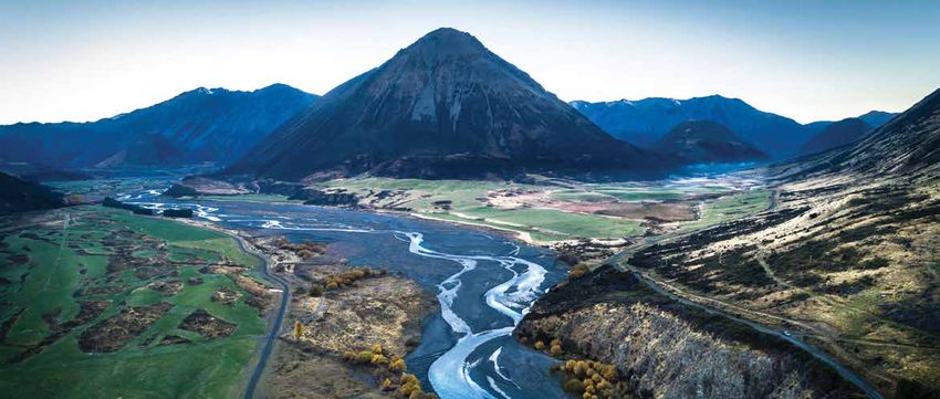
EXECUTIVE SUMMARY
The 2019 Canterbury Water Management Strategy (CWMS) Targets Progress Report is the             A Regional Committee was also established to address regionally-significant water
fourth prepared by Environment Canterbury to demonstrate progress on achieving the              management issues such as infrastructure and environmental enhancement projects.
CWMS Targets. The Targets were approved by the Mayoral Forum in 2010 and took a thirty-
                                                                                                Stakeholders and partners remain at the heart of the CWMS.
year time horizon through to 2040. The vision of the CWMS has remained constant during
the past nine years of operation:                                                               The partners include:
                                                                                                • Canterbury Mayoral Forum
“To enable present and future generations to gain the greatest social, economic, recreational
                                                                                                • Ashburton District Council
and cultural benefits from our water resources within an environmentally sustainable
                                                                                                • Christchurch City Council
framework.”
                                                                                                • Environment Canterbury
Ten broad target areas were developed to measure and focus progress in identified areas.        • Hurunui District Council
They were signed off in 2010 following comprehensive stakeholder engagement, public             • Kaikōura District Council
consultation and joint collaboration with interest groups and they are:                         • Mackenzie District Council
                                                                                                • Selwyn District Council
•   Environmental limits
                                                                                                • Timaru District Council
•   Ecosystem health/biodiversity
                                                                                                • Waimakariri District Council
•   Natural character of braided rivers
                                                                                                • Waimate District Council
•   Kaitiakitanga
                                                                                                • Waitaki District Council
•   Drinking water
                                                                                                • Te Rūnanga o Ngāi Tahu and
•   Recreational and amenity opportunities
                                                                                                • Ngā Papatipu Rūnanga.
•   Water-use efficiency
•   Irrigated land area                                                                         Planning Frameworks in Place
•   Energy security and efficiency                                                              Canterbury has made significant progress towards setting environmental limits through
•   Regional and national economies                                                             the Land and Water Regional Plan (LWRP) which sets limits that require farmers and other
                                                                                                land users to ‘hold the line’ and not increase nitrate losses. Through the development
The work of the CWMS is ground-breaking. This is a leadership project that demonstrates
                                                                                                of Plan Change 5, Environment Canterbury has worked with the primary sector to define
the strength that is provided through effective engagement and community commitment.
                                                                                                acceptable farming practices. Industry-agreed Good Management Practices (GMPs) now
The CWMS is anchored in successful partnerships with stakeholders. The issue of water has       provide farmers and councils with a shared understanding of how to limit nutrient losses
always been contentious, but the CWMS has shifted community and partnership thinking            and manage environmental impacts.
from a deadlocked position to one where there is now a great deal of consensus.
                                                                                                Sub-regional chapters have also been developed via a detailed and intensive community
From the outset, ten zones were created, based largely on river catchments. Each zone           engagement. Most catchments now have a specific planning framework in place. The
has an appointed Zone Committee tasked with developing a work programme, covering               latest plan change (Plan Change 7) focuses on the Orari-Temuka-Opihi-Pareora (OTOP)
all CWMS target areas, for implementation. Committee members represent the wider                and the Waimakariri Zones.
community interests.
Focus on Action on the Ground Environment Canterbury’s Zone Delivery Teams are supporting the principle of kaitiakitanga
Zone Committees are now supported on the ground by Environment Canterbury Zone on the ground. This includes the work of two Te Pou Mātai, who engage with land owners on
Delivery Teams made up of people with a mix of skills and backgrounds. The Zone Delivery land management issues addressing matters of significance to Ngāi Tahu.
Team members are instrumental in facilitating change to protect and improve water quality
and ecosystem health. They also work with community groups and individuals to support the There continues to be strong leadership around the Zone Committee table by rūnanga
development of restoration projects. representatives to foster greater understanding of tikanga across the committees.
Immediate Steps Biodiversity Fit for the Future
The Immediate Steps biodiversity protection and restoration programme continues to be In 2017 the Fit for the Future project was undertaken to make sure that ten years on, the CWMS
an integral part of the CWMS. Immediate Steps was established to protect and restore targets were still relevant and aligned with requirements. It was important that new knowledge
biodiversity in and around freshwater habitats. Funding is allocated to on-the-ground actions and enhanced science, now available to inform decision making, was incorporated in the
aimed at halting or reversing the decline in indigenous biodiversity. By May 2019, more than strategy. The project has resulted in a reconfirmation of the targets and the task ahead, as well
510 projects had been awarded funding from the Immediate Steps biodiversity project. as the introduction of new interim targets and additional work programmes to help measure
This totalled $10.3 million, with projects including more than 530,000 native plantings and and guide progress.
the erection of almost 560km of fencing to protect 2,100 ha of stream riparian margins, Partners have agreed to commit additional and renewed resource to achieving the goals and
wetlands, lagoons and native bush. targets of the strategy. This resource commitment is important as the strategy shifts into strong
Farming to Good Management Practice delivery mode with planning and preparation now largely complete.
There is science-based evidence that demonstrates the long-term decline in water quality is Challenges and opportunities
slowing, with early signs of environmental and ecological improvement. Improvements have While progress has been made towards achieving the targets, there are still challenges ahead of
been achieved due to stricter and more targeted planning rules, more planting and fencing of us, like dealing with the ‘lag’ effect and long timeframes of freshwater systems. Much of what is
streams, better effluent management, improved irrigation practices, biodiversity restoration being dealt with now are ‘legacy issues’ and will take a significant time to remediate.
projects, smarter technology and investment in on-farm systems, better on-farm training,
Demonstrating the “cause and effects” of water management is made all the more difficult
improved compliance and monitoring, as well as the programme of industry agreed Good
by the complexity of freshwater systems, scientific uncertainty and competing stakeholder
Management Practice (GMP) and the introduction of audited Farm Environment Plans (FEPs)
demands. Additional work is needed to understand recreational values, improving management
for most farms in Canterbury. By June 2019, 81% of the required FEPs were in place and have
of braided rivers and mahinga kai, monitoring and use of data to better report against the targets.
been audited at least once or will receive their first audit within the next year. These figures
Improved monitoring and reporting of ecosystem health and biodiversity outcomes needs to be
demonstrate the willingness of the farming community to work with the Zone Committees and
established so that outcomes rather than activities can be reported. Monitoring and reporting
within the restrictions of the Land and Water Regional Plan (LWRP) to achieve target outcomes.
on the achievement of nutrient efficiency targets is also important as improved water quality
Engagement with Papatipu Rūnanga underpins progress in ecosystem health, recreational, mahinga kai and drinking water targets.
As tangata whenua, Ngāi Tahu are integral to the CWMS. The Tuia Relationship Agreement
This report signals that the next few years need to focus on implementation. Primary industry
between Ngā Papatipu Rūnanga and Environment Canterbury recognises the mana whenua
groups, NGOs, councils, iwi, voluntary groups, health boards and many others have a part to
status of ngā rūnanga and provides for the development of operational protocols across
play. Implementation of community recommendations is impossible unless we work together.
Environment Canterbury’s functions, powers and responsibilities. The Tuia Joint Work
Programme has resulted in changes in organisational culture, processes and engagement This report covers progress against the targets specified in the CWMS but describes only part of
practices and improved relations and interaction with Ngāi Tahu, particularly at a rūnanga level. the story. To learn more visit www.ecan.govt.nz/canterburywater.TABLE OF CONTENTS
CHAPTER 1: ENVIRONMENTAL LIMITS..................................................1 CHAPTER 6: RECREATION AND AMENITY OPPORTUNITIES................... 30
Environmental Flows and Catchment Load Limits.............................................2 Water Based Recreational Opportunities...................................................... 30
Freshwater Angling.................................................................................... 31
CHAPTER 2: ECOSYSTEM HEALTH AND BIODIVERSITY........................... 4 Recreational Water Flows........................................................................... 32
Freshwater Species and their Habitat............................................................ 4 Recreational Water Quality.........................................................................34
Wetlands................................................................................................... 6
Drylands.................................................................................................... 8 CHAPTER 7: WATER-USE EFFICIENCY............................................... 36
Hāpua, Lagoons and Estuaries.....................................................................10 Best Practice and Benchmarking..................................................................36
Lowland Streams and Lakes........................................................................ 12
High Country and Foothill Streams and Lakes................................................ 14 CHAPTER 8: IRRIGATED LAND AREA................................................. 38
Understanding Emerging Contaminant Risks.................................................. 16 Land Area and Reliability............................................................................38
Infrastructure........................................................................................... 40
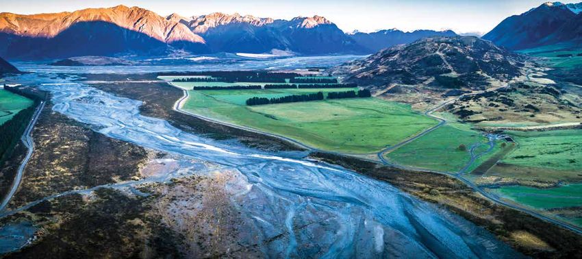
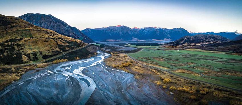
CHAPTER 3: NATURAL CHARACTER OF BRAIDED RIVERS...................... 17
Braided River Character.............................................................................. 17 CHAPTER 9: ENERGY SECURITY AND EFFICIENCY............................... 42
Ecosystems, Habitats and Species/Riparian Wetlands, Springs and Lagoons..... 20 Energy Security and Efficiency.....................................................................42
CHAPTER 4: KAITIAKITANGA............................................................22 CHAPTER 10: INDICATORS OF REGIONAL AND NATIONAL ECONOMIES.. 43
Marae Water Supply................................................................................... 22 Added-value from Water.............................................................................43
Working Together in Partnership.................................................................. 23 Externalities and Opportunity Costs.............................................................44
Wāhi Taonga and Mahinga Kai.....................................................................24
GLOSSARY................................................................................... 46
CHAPTER 5: DRINKING WATER........................................................ 26
Source Water Quality..................................................................................26
Catchment Nutrient Load............................................................................28CHAPTER 1: ENVIRONMENTAL LIMITS
FIG 1: CANTERBURY WATER MANAGEMENT STRATEGY WATER ZONES
A collaborative Canterbury process brought to you by:
Kaikōura Zone
• Canterbury Mayoral Forum - Arowhenua Waiau Toa/
• Ashburton District Council - Kaikōura Clarence River
• Christchurch City Council - Koukourārata
• Environment Canterbury - Moeraki
• Hurunui District Council - Ngāi Tūāhuriri
• Kaikōura District Council - Ōnuku
Hurunui Waiau Zone Waiau Uwha River
• Mackenzie District Council - Rāpaki
• Selwyn District Council - Te Taumutu
Hurunui River
• Timaru District Council - Wairewa
• Waimakariri District Council - Waihao
• Waimate District Council
Waimakariri Zone
• Waitaki District Council Ashley River/Rakahuri
• Te Rūnanga o Ngāi Tahu Waimakariri River
• Papatipu Rūnanga Christchurch - West Melton Zone
Selwyn Waihora Zone
Banks Peninsula Zone
Ashburton Zone
Rakaia River
Orari, Temuka, Opihi, Ashburton River/Hakatere
Pareora Zone
Upper Waitaki Zone Rangitata River
Orari River
Lower Waitaki - South
Coastal Canterbury Zone
Waitaki River
1CHAPTER 1: ENVIRONMENTAL LIMITS
ENVIRONMENTAL FLOWS AND CATCHMENT LOAD LIMITS
The collaborative process is at the heart of the CWMS. It empowers communities to make their own decisions about how best to meet agreed, regionwide and local targets. Through
the CWMS, the process of setting environmental limits (including environmental flows, allocation limits and nutrient loads) provides an opportunity for the community to take local
ownership of water management, and to work together through complex information, to reach decisions around priority outcomes and values.
Zone Committees and communities are working collaboratively through the Resource Management Act (RMA) plan development timetable. This intensive process transfers the priority
outcomes and values into resource management plans, supports Environment Canterbury to meet its statutory responsibilities, achieves sustainable management of the region’s water
and land resources and aligns the planning framework to CWMS targets.
T3 T1, T2
Targets Progress to 2020 Not started Started Progress Good progress Achieving
By 2015: • Target 1: Environment Canterbury has made significant protection, and the exclusion of livestock from lakes and
Target 1: Set environmental flows for surface streams, rivers and progress towards setting environmental limits through the rivers. Plan Change 4 was made operative in March 2017.
groundwater that are consistent with the fundamental principles of Land and Water Regional Plan (LWRP). The LWRP, effective • Plan Change 5 to the LWRP requires farmers to reduce
the CWMS. Set catchment load limits for nutrients for each water from January 2012, sets environmental limits that require nutrient losses and manage their land in an environmentally
management zone that are consistent with the fundamental principles farmers and other land users to ‘hold the line’ and not sustainable way. Environment Canterbury has worked with
increase nitrate losses. the primary sector over several years to define acceptable
of the CWMS. Established and began to implement a programme to
• The LWRP provides a region wide planning framework farming practices. GMP now provides farmers and council
apply environmental flows to existing consents. within which catchment specific plan changes (sub-regional with a shared understanding of how to limit nutrient losses
chapters) are added which introduce local limits. These and manage environmental impacts. Plan Change 5 was
By 2020: sub-regional chapters are developed via a detailed and made operative in March 2019.
Target 2: Review of environmental flows and catchment load limits in intensive community engagement process taking up to 2-3 • A series of sub-regional plan changes have now put into
response to changing monitoring information, new understanding and years to complete. Most catchments now have a specific effect localised rules for nutrient management across
technologies, and if requested by Regional and Zone Committees. planning framework in place. See fig 2 for progress on these Canterbury – See fig 2.
Target 3: Established and began to implement a programme to numbered plan changes. • Zone Committees have been central to developing the
review existing consents where such review is necessary in order to • Plan Change 7 (under consultation in 2019) focuses on the sub-region planning framework and are now increasingly
achieve catchment load limits. Orari-Temuka-Opihi-Pareora (OTOP) and the Waimakariri focused on delivery of a work programme.
Zones. Both zones are looking to make further reductions • Target 2: Catchment loads and flows are being monitored
beyond ‘Good Management Practice’ (GMP) and improve by Environment Canterbury through its regular state-of-
By 2040: minimum flows. There is also an omnibus component to the-environment monitoring programme at more than 400
Review of environmental flows and catchment load limits this plan change which covers regionwide issues including; groundwater sites and 160 surface water sites. Water levels
in response to changing monitoring information, new greater protection to habitats of freshwater species, and river flows and water quality are monitored monthly
understanding and technologies, and if requested by Regional enabling consideration of Ngāi Tahu values in relation and include over 90 recreational sites. Zone Committees are
and Zone Committees. Environmental flow and catchment load to a broader range of activities, supporting the use of regularly updated with this information.
managed aquifer recharge, and providing a revised nutrient • Target 3: Specific catchment load limits have been, or are
limits achieved in all water bodies.
framework for commercial vegetable growing operations. being, set in sub-regional plans; for progress, see fig 2.
• In addition to sub-regional plan changes, a suite of Environment Canterbury continues to monitor and model
improvements was made to the LWRP through the previous catchment loads and work through Zone Committees
Omnibus change (Plan Change 4), relating to improved to determine whether consent reviews are necessary to
biodiversity outcomes, protection of īnanga spawning achieve catchment load limits.
habitat, storm-water management, drinking water source
2CHAPTER 1: ENVIRONMENTAL LIMITS
FIG 2: PROGRESS ON CATCHMENT LEVEL ENVIRONMENTAL LIMIT SETTING
Hurunui Waiau
• Environmental limits for Hurunui and Waiau Uwha rivers established in 2013 in the Hurunui Waiau Rivers Regional Plan (HWRRP).
• Plan Change 1 is a targeted plan change addressing the cumulative effects of land use on water quality for dryland farmers. Kaikōura
Waimakariri
• Zone Committee completed a solutions package with environmental limits and complementary on-the-ground actions
at the end of 2018. The plan change will incorporate part of the Waimakariri River Regional Plan (WRRP) into the LWRP.
• Plan change was notified on 20 July 2019.
Selwyn Waihora/Wairewa (Plan Change 1 and 6) Hurunui Waiau
• Selwyn Te Waihora Plan Change 1 to the LWRP made operative February 2016.
Implementation of Selwyn Waihora Plan Change is underway, progressing on-the-ground actions.
• Wairewa Plan Change 6 to the LWRP made operative February 2017.
Implementation of Wairewa Plan Change is underway, progressing on-the-ground actions.
Ashburton to Rakaia Catchment Waimakariri
• A consent review on the Hakatere/Ashburton
River is being undertaken by the Ashburton Zone Committee. Christchurch - West Melton
Hinds Catchment (Plan Change 2)
• Hinds Plan Change 2 to the LWRP made operative from June 2018.
Selwyn Waihora
Implementation of Hinds Plan Change is underway, progressing /Wairewa
on-the-ground actions.
Orari-Temuka-Opihi-Pareora
Banks Peninsula
• Zone Committee completed a solutions package with environmental Ashburton to Rakaia
limits and complementary on-the-ground actions at the end of 2018.
The plan change will incorporate the Opihi and Pareora catchment Hinds Plains
plans into the LWRP.
• Plan change was notified on 20 July 2019.
Orari-Temuka-Opihi-Pareora
South Coastal Canterbury (Plan Change 3)
• South Coastal Canterbury Plan Change made operative September Environmental Limit Setting - Status
2017. Implementation of South Coastal Canterbury Plan Change South Coastal Canterbury Zone Implementation Programmes
is underway, progressing on-the-ground actions.
Community Collaboration
Waitaki (Plan Change 5, Part B)
Waitaki
• Waitaki Plan Change 5 to the LWRP made operative from February 2019. Drafting Catchment-Specific Plan Changes
Implementation of Waitaki Plan Change is underway, progressing Submissions and Independent Hearings
on-the-ground actions.
Plan Operative
These Zone Committees are working towards recommending a Solutions Package with environmental limits for their zones:
• Christchurch West Melton
• Kaikōura 3
• Banks PeninsulaCHAPTER 2: ECOSYSTEM HEALTH AND BIODIVERSITY
FRESHWATER SPECIES AND THEIR HABITAT
Freshwater environments and their inhabitants have considerable ecological and cultural value. Yet several native freshwater species are in decline or are nationally threatened. Other
introduced species are of significant value to recreational fisheries but can pose a threat to native freshwater fish. A regional habitat restoration programme is underway and takes a
catchment-based approach to restoring the habitat of freshwater fish species.
T1, T2 T3, T4
Targets Progress to 2020 Not started Started Progress Good progress Achieving
From 2010: • Target 1 & 2: The LWRP maps and protects salmon spawning sites. Further report identifies that the Canterbury mudfish/kōwaro’s already fragmented
Implement actions to correct the plan changes are in development to increase the number of spawning sites range has further contracted. Populations are now compromised by drought
decline in freshwater species, with regulatory protection. conditions and exacerbated by abstraction of irrigation water, continued
habitat quality or ecosystems. Fish & Game NZ data shows that across the range of spawning surveys agricultural development leading to loss of wetland and meandering stream
completed over the past 11 years, there continues to be a significant habitat and closure of stock water races. The report notes that its survival
By 2015: downward trend in salmon spawning numbers. is now tenuous. With regards to longfin eel/kūwharuwharu, there are still
Target 1: No further reduction in concerns over the continuing degradation of its habitat (especially in lowland
The LWRP includes rules that exclude stock from rivers and lakes. Further areas) and on-going issues with fish passage (upstream and downstream)
the number and areas of existing plan changes in development are exploring the potential for extending these and water quality.
salmon spawning sites. rules. Fish & Game NZ continues to work with high country landowners, to
Target 2: Increasing annual trout protect and restore riparian areas and minimise intensive farming practices Monitoring is also conducted to assess the outcomes of specific projects.
upstream and adjacent to spawning streams. The LWRP identifies and Over the last two years, the Banks Peninsula Zone Committee has undertaken
spawning counts in identified
protects īnanga spawning habitat on planning maps and has specific rules fish surveys and culvert assessments on several streams to improve
important areas (based on a understanding of barriers to fish passage. These surveys have identified
5-year average) as an indicator of for excluding stock from these habitats on the bed and banks of lakes,
permanently or intermittently flowing (but not ephemeral) rivers, artificial significant populations of banded kōkopo some of which are negatively
habitat availability for salmon and impacted by culverts. Work is now underway to address barriers and enhance
watercourses, coastal lagoons or wetlands. Further plan changes in
indigenous fish species. development will provide similar protection to other indigenous fish species’ habitats on these streams.
spawning habitats. • Target 4: Over 50% of the Immediate Steps biodiversity projects since
By 2020: Under the direction of the Zone Committees, the Immediate Steps biodiversity 2010 are dedicated to fencing and planting, see fig 3. In 2017 NIWA began
Target 3: An upward trend in programme invested in 60 projects aimed at improving fish habitat. A key a five-year nationwide study to find out what approaches work best and
diversity and abundance of native 2018 project of the Regional Committee was to investigate the effectiveness to provide better guidance for people and groups undertaking stream
fish populations. of fish screens focussing initially on 50 consents at key sites with fish screen restoration. The first part of the study involves registration of as many riparian
Target 4: Increased the length conditions. Environment Canterbury is working with consent holders to projects as possible through the National Riparian Restoration Database.
of waterways with riparian upgrade their screens and/or put in place interim measures. Between July The Christchurch City Council’s work with its community on the restoration
2014 and June 2018, landowners, community groups, the Department of of the Ōtukaikino River has led to an extensive fencing and riparian planting
management appropriate to
Conservation (DOC) and Environment Canterbury, worked together on the programme which has been a key factor in reducing phosphorus.
aquatic ecosystem protection by
Regional Fish Habitat Initiative (RFHI)and supported 14 key projects. In 2017 Fonterra committed to a plan that will build on previous work to improve
50% from 2010 figures.
Projects to improve fish habitat received $365,000 from Immediate Steps the quality of New Zealand waterways by farming within environmental limits,
funding and leveraged a further $340,000 from land owners and agencies to encouraging sustainable practises, improving water use efficiency, investing in
protect mudfish and īnanga spawning sites and erect fish barriers. The next science and building partnerships.
phase will focus on improving habitat of longfin eel/kūwharuwharu and fish District Plan reviews underway in Waimakariri, Selwyn, Timaru, Mackenzie and
passage. Waitaki Districts are providing the opportunity for Environment Canterbury
• Target 3: Native fish monitoring falls across several agencies (e.g. DOC, and District Councils to work together to provide for more protection and
NIWA). DOC’s 2017 Conservation Status of New Zealand Freshwater Fishes enhancement of riparian margins.
4CHAPTER 2: ECOSYSTEM HEALTH AND BIODIVERSITY
FIG 3: IMMEDIATE STEPS PROJECTS
Fig 4: Immediate Steps Projects by Zone
Immediate Steps Programme Progress to date
Launched in 2010, the Immediate Steps biodiversity protection and restoration
programme continues to be an integral part of the CWMS.
Project Numbers
Through Immediate Steps, $2 million is available annually for protecting and restoring • More than 510 Immediate Steps
biodiversity in and around freshwater habitats. biodiversity projects
Funding is allocated to on-the-ground actions aimed at halting or reversing the decline
in indigenous biodiversity.
Project recommendations are considered by Zone Committees and the Regional Dollars
Committee, with guidance from Environment Canterbury’s biodiversity officers working in • $10.3m spent on Immediate Steps
zone delivery teams and working alongside Canterbury Biodiversity Strategy partners. biodiversity projects
Why is Immediate Steps needed?
Freshwater ecosystems provide an important habitat for many fish, insects, plants and
birds. They act as corridors and ‘stepping stones’ that connect different habitats and
ecosystems. Native biodiversity has declined over many years. Increased intensive Fencing
land use such as vegetation clearance, water and gravel abstraction along rivers • 560km of fencing to protect 2,100 ha of
and streams, has degraded the natural habitat and caused pollutants to enter these stream riparian margins, wetlands, lagoons
freshwater ecosystems. and native bush
The CWMS has highlighted declining health of the region’s freshwater ecosystems and
the loss of native biodiversity as a key community concern for which specific targets
have been set.
Plants
Immediate Steps flagship projects • More than 530,000 native plantings
The Regional Committee has decided on three flagship projects to support over the next
five years: Te Waihora/Lake Ellesmere enhancement project; The Braided River Flagship
project with a focus on enhancement of the upper catchments of the Rakaia and
Rangitata rivers; and the Wainono Lagoon project.
5CHAPTER 2: ECOSYSTEM HEALTH AND BIODIVERSITY
WETLANDS
Wetlands, riparian margins and other areas of indigenous vegetation create habitats for indigenous fauna and have important natural character values. In Canterbury, less than
10 percent of the region’s previously extensive freshwater natural wetlands remain. Drivers of wetland loss since European settlement include drainage; diversion of water, infilling,
reclamation, urban development, flooding, fire, vegetation clearance, cultivation, grazing and spread of introduced species. The mapping of wetlands, and wetland projects, helps us
paint a picture of where remaining wetlands are, whether they are protected, and where protection efforts should be targeted. Planning provisions that protect the biodiversity values
of natural wetlands are critical and are included in Canterbury’s regional policy statement and plans. The Canterbury Land and Water Regional Plan (LWRP) requires the protection and
maintenance of wetlands that contribute to cultural and community values, biodiversity, water quality, mahinga kai, water cleansing and flood mitigation.
T1
Targets Progress to 2020 Not started Started Progress Good progress Achieving
From 2010: • The Immediate Steps biodiversity programme implements two to minimise the risk of nutrient, faecal bacteria and sediment loss
Prevent further loss of area of naturally occurring or more wetland protection and restoration projects for naturally to water bodies, including wetlands. 81% of farms requiring FEPs in
wetlands. occurring wetlands, every year, in each CWMS zone. Approximately Canterbury now have them in place. They have been audited at least
$2.3m of Immediate Steps funding has been invested in 157 wetland once or will receive their first audit within the next year.
By 2015: projects across the region. Of these wetland project sites, 50 have • Environment Canterbury has entered into a 3-year partnership
Protected all and restored at least two significant legal protection. project with landowners, NZ Landcare Trust, Federated Farmers,
wetlands in each zone. • Environment Canterbury has updated its publicly available MPI and others with a focus on helping farmers develop best
‘Canterbury Wetlands’ geographic information system (GIS) layer on management practices to sustainably manage wetlands located
Canterbury Maps. The updated layer provides an important source on working farms. Approximately $0.5m of MPI funding and over
By 2020/2040: of information and guidance for both landowners and Environment $0.5m Environment Canterbury funding has been invested in the
Protected all wetlands. Canterbury when seeking to identify and protect wetlands. It is project plus in-kind support from landowners. The project will
important to note that there may be additional wetlands within include 30 demonstration wetlands with the aim of identifying how
the region that have not been identified and are not included in wetlands can be managed to recognise economic, environmental,
the information Environment Canterbury holds. Consequently, recreational and cultural values.
the layer on Canterbury Maps should be considered as showing • Under the newly established Regional Wetlands Programme,
indicative wetlands. The layer will be updated as new information is Environment Canterbury is working with willing landowners to
collated including corrections where new information addresses any develop tailored wetland action plans to protect ecologically
mapping errors. significant wetlands on private and public land across Canterbury.
• Wetlands remain subject to core provisions of the RMA that apply to In the first year (2018-19), 12 projects with associated action plans
freshwater bodies and the Coastal Marine Area. Additional planning are being developed, with a total of $130,000 allocated to support
provisions offer protection through the LWRP including policies protection works (fencing, weed control, predator control and
where intensively farmed stock must be excluded from lakes, rivers monitoring).
and wetlands. • Ō Tū Wharekai (Ashburton Lakes/upper Rangitata River) is one of the
• Potential effects on wetlands, including ecological effects, best examples of an intermontane wetland system remaining in New
are assessed as part of consent application processes where Zealand and one of the three sites in DOC’s national Arawai Kākāriki
appropriate and required. wetland restoration programme. The wetland restoration protection
• FEPs are developed by farmers to identify at-risk areas on farms, and programme includes weed control, predator control, managing
to provide guidance on management activities (e.g. stock exclusion) impacts of recreation, researching new wetland management
methods, and education and awareness programmes.
6CHAPTER 2: ECOSYSTEM HEALTH AND BIODIVERSITY
FIG 4: WETLAND PROJECTS
Immediate Steps Wetland Projects Waiau Toa/
Clarence River
Fig 4: Immediate Steps Projects by Zone
Progress to date
Project Numbers Waiau Uwha River
• 157 Immediate Steps
biodiversity projects Hurunui River
Dollars
Ashley River/Rakahuri
• $2.3m spent on Immediate Steps
biodiversity projects Waimakariri River
Rakaia River
Ashburton River/Hakatere
Rangitata River
Orari River
Waitaki River
7CHAPTER 2: ECOSYSTEM HEALTH AND BIODIVERSITY
DRYLANDS
Drylands are unique ecosystems that provide habitat for rare and threatened species. Presently only approximately 3% (60,000ha) of dryland ecosystems in Canterbury are protected. Projects
for protection and restoration are underway. Priority needs to be given to effective planning and regulatory mechanisms to ensure no further loss of remaining dryland biodiversity.
T1
Targets Progress to 2020 Not started Started Progress Good progress Achieving
From 2010: Maintain existing high quality indigenous aquatic and • During the 2009-19 period Zone Committees awarded • Te Manahuna Aoraki is a large-scale conservation
dryland ecosystems in intermontane basins and on the plains. $970,000 Immediate Steps biodiversity funding to 68 programme restoring natural landscapes and threatened
projects at 37 locations for dryland ecosystem protection species across more than 300,000ha of the upper
including intermontane streams. (Fig. 5). Under the Mackenzie Basin and Aoraki National Park. Founding
Canterbury Biodiversity Strategy fund, an additional 68 partners DOC, NEXT Foundation, Te Rūnanga o Arowhenua,
projects have been undertaken in dryland ecosystems, with Te Rūnanga o Waihao and Te Rūnanga o Moeraki have
$580,000 of funding committed from 2009-19. been joined by high country runholders, LINZ, the Ministry
• The Mackenzie Basin has been recognised for its extensive, of Defence, and investors Predator Free 2050, Aotearoa
relatively unmodified dryland ecosystems that provide Foundation, Jasmine Social Investments and Global Wildlife
critical habitat for a range of indigenous plant and animal Conservation. In the first year of operation (2018-19), the
species. Over the last two decades there has been project has established predator trapping networks along
substantial habitat loss in this area due to agricultural the Cass, Godley, Macauley and Tasman Rivers, undertaken
intensification. Similar patterns of land use change are weed control work, and begun trialling a predator exclusion
occurring in other parts of the Canterbury high country: fence to protect robust grasshopper habitat.
for example, more than 3,000ha of land was converted to • DOC has established a project management team to
intensive agricultural use in the upper Rakaia catchment investigate and launch a proposal for a Mackenzie Dryland
between 2008-16. Heritage Area.
• Both the Upper and Lower Waitaki Zone Committees • Wilding conifers pose a serious threat to Canterbury’s
set community outcomes to protect and enhance the indigenous dryland ecosystems. Phase I (2016-19) of
biodiversity of water bodies and high quality drylands. The the National Wilding Conifer Control Programme (MPI,
Waitaki section of the LWRP limits the scope of dryland DOC, LINZ, New Zealand Defence Force and Environment
development. Canterbury) has been very effective in controlling sparse
• In 2017 the five agencies involved in the management of infestations of wilding conifers and preventing further
the Mackenzie Basin (Mackenzie District Council, Waitaki spread in the Canterbury hill and high country.
District Council, DOC, Land Information New Zealand (LINZ) From 2016-18, over 1.2 million ha were searched, and
and Environment Canterbury) formed the Mackenzie Basin sparse/outlier infestations were removed. Approximately
Agency Alignment Programme. The goal of the Programme 25,000ha of intermediate-to-high density infestations were
is to make a transformational shift in the way that agencies also treated. More dense infestations will be addressed in
work together to undertake their statutory functions, Phase II of the programme. Further work between agencies
leading to improved environmental and community is needed to establish the status and understand priorities.
outcomes in the Basin. The work programme includes the Te
Manahuna Aoraki initiative.
8CHAPTER 2: ECOSYSTEM HEALTH AND BIODIVERSITY
FIG 5: DRYLAND PROJECTS
Immediate Steps Dryland Projects
Waiau Toa/
Clarence River
Fig 4: Immediate Steps Projects by Zone
Progress to date
Project Numbers
Waiau Uwha/River
• 68 Immediate Steps
biodiversity projects Hurunui River
Dollars
• $970k spent on Immediate Steps Ashley River/Rakahuri
biodiversity projects Waimakariri River
Rakaia River
Ashburton River/Hakatere
Rangitata River
Orari River
Waitaki River
9CHAPTER 2: ECOSYSTEM HEALTH AND BIODIVERSITY
HĀPUA, LAGOONS AND ESTUARIES
Hāpua, lagoons and estuaries are examples of coastal aquatic environments where the mix of coastal, surface water and groundwater produces an often dynamic environment from freshwater
through to brackish and saline conditions. These areas provide an important habitat for a diverse array of native plant and animal species including mahinga kai species such as tuangi (cockles),
pipi which is endemic to New Zealand, harakeke (flax), and tuna (eel). They also provide important nursery and spawning grounds for marine and freshwater fish species such as īnanga
(whitebait), pātiki (flounder) and margin habitats for the kowaro (Canterbury mudfish). Examples in Canterbury include hāpua river mouths such as the Rakaia, Ashburton, Hurunui and Conway
rivers; Waituna type lagoons or coastal lakes such as Te Waihora/Lake Ellesmere and Wainono Lagoon; tidal estuaries such as the Estuary of the Heathcote/Ihutai and Avon/Ōtākaro Rivers or
freshwater river mouths such as the Waiau Toa/Clarence River.
Te Waihora is one of New Zealand’s most important wetlands and is internationally significant for its abundance and diversity of wildlife. Te Waihora is a taonga, central to Ngāi Tahu culture, and
is valued for its recreation and cultural worth, and unique ecological value. There are many active organisations and agencies involved in work to protect, restore and enhance Te Waihora.
T2 T1
Targets Progress to 2020 Not started Started Progress Good progress Achieving
From 2010: Target 1: Whakaora Te Waihora is an operational programme • Te Waihora established as a centre for education and
Implement actions to prevent further loss of ecosystem health in river of the Te Waihora Co-Governance Group (members include Te research.
mouths and coastal lagoons. Rūnanga o Ngāi Tahu, Environment Canterbury, Selwyn District • Mahinga kai values will be restored in Te Waihora.
Council, and Christchurch City Council, with DOC accepting an
Key achievements in 2018/19 include:
By 2015: invitation to join). The programme is working towards achieving
Target 1: Accelerate the current riparian restoration and the vision “To restore and rejuvenate the mauri and ecosystems • The Whakaora Te Ahuriri (Restoration of Ahuriri) project was
management programme for Te Waihora/Lake Ellesmere and of Te Waihora and its catchment” in two generations (35-40 launched.
tributary streams. years). • The management of Te Repo Orariki (Taumutu Wetlands) was
Phase One of the Whakaora Te Waihora programme (2012- handed back to Te Taumutu Rūnanga.
By 2020: 2017) made a significant start to the long-term restoration of Te • Riparian restoration actions were progressed along Te
Target 2: A significant protection and restoration programme is in Waihora/Lake Ellesmere and its catchment. During Phase One Waikekewai/Waikekewai Stream, in partnership with Te
place on the most ecologically significant river mouth or coastal the programme established a robust programme management Taumutu Rūnanga.
lagoon in each management zone. structure that delivered many projects covering biodiversity, • The Weed Strike Force was initiated, which is accelerating
science, engineering, culture, extension, and communication. A the control of willow and weeds at priority sites on the lake
summary of these project achievements is available at shore of Te Waihora (delivered by DOC and co-funded by
By 2040:
www.tewaihora.org under ‘Achievements of Phase One’. Environment Canterbury and Whakaora Te Waihora).
Examples of thriving coastal lagoons and lowland or spring-fed
ecosystems in each water management zone. In Phase Two (2017-2027), the programme is delivering projects • The trial re-establishment of macrophytes/water plants in Te
under six work packages: Waihora was progressed (delivered by NIWA).
• Reducing the legacy phosphorus and sediment in Te Waihora. • Ongoing support was provided for the Kids Discovery Plant-
• Major water quality improvement of Te Waihora. out (delivered by Te Ara Kākāriki and working with 11 schools).
• Transforming the lake shore to wetlands. Target 2: See fig 6. A significant project is underway in nine of
• Enhancing the riparian linkages from the catchment to the the water management zones.
lake shore.
10CHAPTER 2: ECOSYSTEM HEALTH AND BIODIVERSITY
FIG 6: SIGNIFICANT PROJECTS ON RIVER MOUTHS OR COASTAL LAGOONS
Significant Projects by Zone 1
1. Waiau Toa/Clarence River: The survey of black-billed 7. Wakanui Beach: The Zone Committee has been Waiau Toa/
gull/tarāpuka along the Waiau Toa/Clarence River will supporting the management plan for Wakanui Beach Clarence River
assist in our understanding of faecal indicator bacteria working with Forest & Bird and the Ashburton District
concentrations in the river water in the lower reaches. Council.
2. Waipara River Hāpua: Environment Canterbury has 8. Milford Lagoon: This Lagoon is a nationally important
undertaken work to improve understanding of factors breeding area and nursery for fish. The OTOP Zone
affecting the water quality of the hāpua. Environment Canterbury Committee is funding a project working together with the Waiau Uwha River
has also been undertaking work to assess the trophic state of landowner to improve habitat for native species including
hāpua using the Waipara Hāpua as a case study. the Secretive Bittern and native fish including īnanga Hurunui River
3. Pines Beach Wetland: The Waimakiriri Zone Committee species, by undertaking native planting and pest and weed
has been involved with work on this relatively large (37ha) control.
freshwater wetland habitat which is part of the larger 9. Wainono Restoration Project: This regionally-significant 2
sequence of estuarine and freshwater wetland habitats coastal wetland provides habitat to white heron, royal Ashley River/Rakahuri
along the Pegasus Bay coast. The site is distinctive due spoonbill, wrybill, pied stilt, grey teal, eels and īnanga. 3 Waimakariri River
to the presence of locally rare wetland plants (Baumea Improving water quality and habitat of the lagoon through
rubiginosa and Lepidosperma australe) and habitat for the Te Mana o Te Wai project funded by the Ministry for the
the nationally endangered bittern. The Zone Committee Environment continues to be a focus of the Lower Waitaki 4
is working with the three landowners (including the Zone Committee.
Waimakariri Council) and local rūnanga to undertake
6 5
weed control. This project is an extension to the Tūtaepatu
Lagoon project. Rakaia River
4. Stormwater Superhero Campaign: The Christchurch- 7
West Melton Zone Committee has focused on working Ashburton River/Hakatere
with the University of Canterbury on improving stormwater Rangitata River
management through community engagement projects 8 Orari River
aimed increasing knowledge about, and solutions to, the Milford
impact stormwater has on urban waterways and the
Avon-Heathcote Estuary.
5. Te Roto o Wairewa/Lake Forsyth Catchment: The Banks
Peninsula Zone Committee has made significant progress 9
on improving the water quality of Te Roto o Wairewa with
projects to stabilise stream banks to reduce sediment Waitaki River
entering the lake. Macro-invertebrate health has improved Coastal Lakes, Hāpua Lagoons
and Estuaries
at some sites but declined in others. Monitoring results also
show that some streams with good riparian protection are
not yet improving. 11
6. Whakaora Te Waihora: (See main text for progress.)CHAPTER 2: ECOSYSTEM HEALTH AND BIODIVERSITY
LOWLAND STREAMS AND LAKES
Lowland streams and lakes have lower ecosystem health and habitat quality than those in the high country as they are impacted by multiple stressors. These include low flows, habitat
degradation and declines in water quality due to diffuse discharges of agricultural and urban contaminants. Land use is of greater intensity in the flatter low country. Contaminants
accumulate in groundwater, which re-emerges in lowland streams. Spring-fed streams tend to meander through farms and urban areas, and are susceptible to both localised and
diffuse contaminant sources. Actions are underway at numerous sites, catchment-wide, to effect change in land use management that will support all waterways.
T1
Targets Progress to 2020 Not started Started Progress Good progress Achieving
From 2010: Most Zone Committees have identified priority areas according of sites indicate a general grade decline. Of the lowland
Identify and prioritise protection for lowland streams’ ecosystems in to ecological and cultural rankings and have identified streams, 43% of spring-fed streams are in poor or very poor
each zone. projects for Immediate Steps funding in these areas to improve condition, however none of these sites have shown any
biodiversity and water quality values. further decline in grade. 13% of hill-fed streams are in poor
By 2015:
Plan changes to the LWRP are in development phase to align or very poor condition, with 42% showing an improvement
Protect and enhance the ecological health of the best examples
the LWRP with the National Policy Statement for Freshwater in grade. Only one hill-fed site has declined.
of lowland streams ecosystems in each zone. Improve ecosystem
Management. By 2019, Immediate Steps has allocated $1.65m • In 2018, all four sites in urban streams measured for AEH
condition in at least another 10% of lowland streams in each zone.
to 100 lowland stream sites across Canterbury including were considered very poor. Of the four sites measured for
$300,000 to support mudfish habitat enhancement at water quality, one site had a good WQI grade, two sites were
By 2020: Haldon Pasture springs. Christchurch City Council continues considered fair, and one site was considered poor.
Improve condition and water quality in at least 60% of lowland to work on improving water quality of its urban streams by
streams and 60% of lowland lakes in each zone. • Freshwater outcomes for Canterbury Lowland lakes have
managing and treating stormwater, for example through the
been set in the LWRP. Each lake has a set Trophic Level
Ngā Puna Wai stormwater retention basins and the Bells
Index (TLI) based on its characteristics. Five lowland lakes
By 2040: Creek stormwater treatment system. Aquatic Ecosystem
are monitored for water quality in Canterbury; none meet
Health (AEH), habitat and Water Quality Index (WQI), are
100% of lowland areas and spring-fed streams with at least good the TLI targets. Four out of the five lakes are currently
being monitored by Environment Canterbury throughout the
aquatic ecosystem health, or showing an upward trend. considered Hypertrophic, with one considered Eutrophic.
region, including in urban areas (see Fig 7 and Fig 8). Sites are
Efforts are being made by landowners to reduce the amount
selected to represent different river types that encompass
of phosphorus and nitrogen entering the lakes. This includes
various sources of flow, elevations and land uses. AEH grades
significant work with landowners surrounding Te Waihora
and WQI are calculated from this monitoring to give an overall
and Wainono Lagoon. Mudfish, eels, weeds and willows
indication of the general condition of each site monitored.
have been the recent focus of the team working at Wainono
• Lowland streams and rivers have low AEH scores. Data, Lagoon on Te Rūnanga o Waihao’s Te Mana O Te Wai Project.
over the last five years, shows around 39% of lower hillfed The work on improving water quality around and in Te
streams and 67% of spring-fed streams on the plains, Waihora is summarised on page 17.
indicate poor condition. 19% of sites have shown a general
• Environment Canterbury provides data on the state of
decline, while 21% have shown an improvement.
Canterbury’s waterways to the national database – Land,
• The WQI, indicates that around 28% of lowland streams are Air, Water Aotearoa (LAWA). For more information on local
in poor or very poor condition. 42% of lowland sites have to national state and trends of water resources,
shown a general improvement in WQI grades, while 42% visit www.lawa.org.nz.
12CHAPTER 2: ECOSYSTEM HEALTH AND BIODIVERSITY
FIG 7: AQUATIC ECOSYSTEM HEALTH (AEH) AND WATER QUALITY INDEX (WQI) GRADE OF LOWLAND STREAMS
Aquatic Ecosystem Health monitoring is carried out annually, in spring/early summer, at around 200 sites throughout Canterbury.
Streams are chosen to represent the full range of waterways in the region; alpine, lowland, spring-fed and hill–fed.
Waiau Toa/
Ecosystem health is determined according to the number and types of aquatic organisms present at a site. Clarence River
The score for each stream type is standardised against the score from a reference, or ‘best available’, site to control
for natural variability which affects all streams.
A Water Quality Index (WQI) is used to summarise physical and chemical water quality for river and stream sites in Canterbury.
The index compares raw water quality data to recommended water quality guidelines of six key parameters1.
Waiau Uwha River
When deriving a WQI score for a site, the number of parameters that don’t meet the water quality
guidelines are taken into consideration, as well as the frequency and magnitude of transgressions. Hurunui River
This score is ranked to give a single grade from ‘very poor’ to ‘very good’2.
Aquatic Ecosystem Health
Lower hill-fed Spring-fed plains Ashley River/Rakahuri
streams and urban streams Waimakariri River
Rakaia River
Ashburton River/Hakatere
Water Quality Index
Lower hill-fed Spring-fed plains Rangitata River Lowland Stream Monitoring Site
streams and urban streams Orari River
AEH - Grade WQI - Grade
Very Good Very Good
Good Good
Fair Fair
Waitaki River Poor Poor
Very Poor Very Poor
1
The WQI is intended to provide a summary of key water quality parameters, but should be used only as an indicator of overall water quality.
2
Nitrate+nitrite nitrogen, Escherichia coli, Ammonia-nitrogen, Suspended Sediment, Dissolved Reactive Phosphorus, Dissolved Inorganic Nitrogen. 13CHAPTER 2: ECOSYSTEM HEALTH AND BIODIVERSITY
HIGH COUNTRY AND FOOTHILL STREAMS AND LAKES
Water quality in the high country is variable among river types, predominantly influenced by sediment inputs and associated contaminants from overland run-off and stock access.
Aquatic ecosystem health and water quality in the high country is typically higher than in lowland streams, particularly for streams that receive a large volume of flow from higher up in
the catchment. Spring-fed streams in the high country are particularly vulnerable to habitat degradation and siltation through stock access, upwelling of groundwater and associated
contaminants or runoff from intensive land use. Hill-fed streams may be hampered by inflowing spring-fed tributaries or fluxes of contaminant sources during high flows. Alpine and hill
sourced rivers are generally less impacted by contamination sources due to a large volume of flow originating high up in the catchment.
T1
Targets Progress to 2020 Not started Started Progress Good progress Achieving
By 2015:
By 2019, Immediate Steps has allocated $2.9m to 134 • There are specific provisions within the planning
Highlighted any high country spring-fed or foothill streams where
projects in high country and foothill stream catchments. framework that set rules for the management of land
ecosystem health is declining, and identified the cause with an activity around sensitive lake zones in Canterbury
• Plan changes to the LWRP are in development to align the
action plan in place. whereby farming activity will require a resource consent.
LWRP with the National Policy Statement for Freshwater
Management. Environment Canterbury is working with landowners in
By 2020: these lake zones to improve land management practices
• AEH grades (Fig 8) are calculated from this monitoring to
All foothill rivers and high country rivers and/or lakes either in good and improve water quality.
give an overall indication of the general ecosystem health
ecological health or better, or showing upward trends. condition of each site monitored. • There are specific provisions in the LWRP, relating to
vegetation clearance, stock exclusion and earthworks on
• Smaller high-country rivers and streams have variable
river margins.
By 2040: aquatic ecosystem health, depending primarily on the
intensity of land use in their catchments. • Environment Canterbury is working with landowners
Maintained upland spring-fed streams and lakes in very good to protect and maintain riparian margins. It is now a
aquatic ecosystem health (no decline from 2010). 80% of other • The AEH grades indicate that around 32% of sites are
non-complying activity for intensively farmed stock to
rivers/streams and lakes with very good aquatic ecosystem graded good or very good. 25% of sites have shown a
use and disturb the bed and banks of any lake.
general improvement in aquatic ecosystem grade, while
health. • Environment Canterbury provides data on the state of
24% of sites have shown a general decline.
Canterbury’s waterways to the national database – LAWA.
• 42% of sites have shown a general improvement in AEH
For more information on local to national state and trends
grades, while no sites have shown a general decline.
of water resources, visit www.lawa.org.nz.
• The TLI indicates that 81% of high-country lakes are
between Ultramicrotrophic to Mesotrophic.
• Freshwater outcomes for Canterbury’s high-country lakes
have been set in the LWRP. Lakes have a set TLI based
on their characteristics. TLI is calculated using monthly
measurements over summer of three separate factors: total
nitrogen, total phosphorous, and chlorophyll-a. 13 of the 27
regularly monitored lakes currently meet their target TLI.
14You can also read